

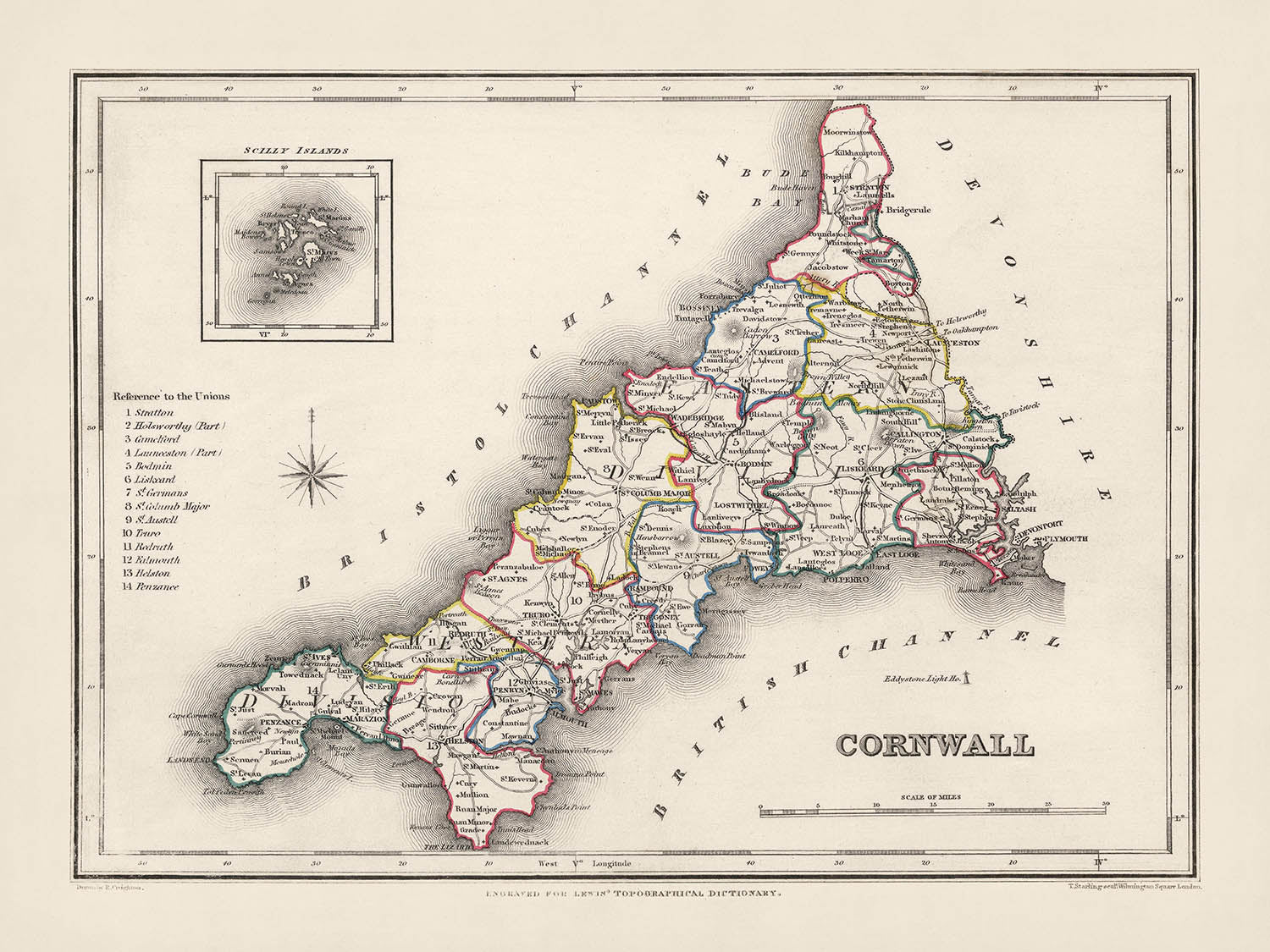


Alte Karte von Cornwall von Samuel Lewis, 1844: St Austell, Truro, Falmouth, Penzance und Newquay
- All taxes and duties included
- Handmade & dispatched in 1-2 days
-
90 day money back guarantee
ⓘ
90 Tage für Rückgabe und Rückerstattung
Produkte können innerhalb von 90 Tagen für eine vollständige Rückerstattung oder einen Umtausch gegen ein anderes Produkt zurückgegeben werden.
Für personalisierte und maßgefertigte Artikel können wir Ihnen möglicherweise einen Gutschein oder eine nicht ablaufende Geschenkkarte anbieten, da wir personalisierte Bestellungen nicht weiterverkaufen können.
Wenn Sie Fragen haben, kontaktieren Sie uns. Für weitere Informationen siehe unsere vollständige Rückgabe- und Umtauschrichtlinie.

My maps are rare, museum-grade, restored old maps sourced from libraries, auction houses and private collections across the globe.
Framing & free personalisation available
1. Select your size
2. Frame & personalise your map
There is limited framing & personalisation capacity available. Order soon for Christmas delivery.


Geschenkmitteilung & individuelle Ausführung

Wenn Sie eine Geschenkmitteilung oder eine Ausführung (Puzzle, Aluminiumplatte usw.) hinzufügen möchten, die hier nicht verfügbar ist, geben Sie dies bitte in der "Bestellnotiz" beim Checkout an.
Jede Bestellung wird individuell angefertigt. Wenn Sie die Größe leicht anpassen oder auf einem ungewöhnlichen Material drucken lassen möchten, lassen Sie es uns einfach wissen. Wir haben im Laufe der Jahre Tausende von individuellen Bestellungen bearbeitet, daher gibt es (fast) nichts, was wir nicht bewältigen können.
Sie können uns auch kontaktieren, bevor Sie bestellen, wenn Sie möchten!

- Handmade locally. No import duty or tax
- FREE Delivery by Christmas
- Love it or your money back (90 days)
- Questions? WhatsApp me any time
Own a piece of history
5,000+ 5 star reviews


Tauchen Sie ein in eine fesselnde Reise durch die Zeit mit dieser makellosen Karte von Cornwall County aus dem Jahr 1844 von Samuel Lewis. Dieses faszinierende Artefakt bietet nicht nur einen spannenden Einblick in Cornwall, wie es im 19. Jahrhundert war, sondern dient auch als Brücke zu seiner lebendigen Vergangenheit. Es ist ein Zeugnis für die Wurzeln der modernen Landschaft Cornwalls, einschließlich Städten, die Sie heute möglicherweise nicht mehr unter denselben Namen finden.
Hier ist eine aufregende Gelegenheit, dieses Stück Geschichte zu erkunden, wo Sie frühe Versionen moderner Städte entdecken oder in einigen spannenden Fällen Siedlungen finden könnten, die auf zeitgenössischen Karten überhaupt nicht erscheinen. Diese Karte enthält auch eine Detailkarte der Scilly-Inseln, die diesem bereits faszinierenden Stück eine weitere Ebene des Interesses hinzufügt.
Siedlungen innerhalb der historischen Grenzen von Cornwall
- St Austell: Gegründet im 12. Jahrhundert. Bekannt für seine Kaolinindustrie.
- Truro: Im 12. Jahrhundert als Stadt gegründet. Bekannt für die Kathedrale von Truro und als Verwaltungszentrum von Cornwall.
- Falmouth: 1661 charterisiert. Berühmt für seinen tiefen Naturhafen.
- Penzance: Erhielt 1332 Marktrechte. Tor zu den Scilly-Inseln.
- Newquay: Im 15. Jahrhundert als Fischerdorf bekannt. Berühmt als Surf-Destination.
- Camborne: Im Domesday Book von 1086 erwähnt. Historische Bergbaustadt.
- Redruth: Bekannt seit dem 12. Jahrhundert. Ein weiteres Zentrum der Bergbauindustrie in Cornwall.
- Saltash: Im 12. Jahrhundert als Marktstadt erwähnt. Bekannt für die Royal Albert Bridge.
- Bodmin: Im Domesday Book von 1086 aufgezeichnet. Heimat von Bodmin Jail und Bodmin Moor.
- St Ives: In Aufzeichnungen aus dem 5. Jahrhundert erwähnt. Bekannt als Künstlerparadies.
- Liskeard: Im Domesday Book von 1086 erwähnt. Tor zu Bodmin Moor.
- Launceston: Im Domesday Book von 1086 aufgezeichnet. Historische Hauptstadt von Cornwall.
- Helston: Seit mindestens 1086 als Stadt bekannt. Berühmt für den Furry Dance.
- Porthleven: Im frühen 19. Jahrhundert als Hafen gegründet. Bekannt für seinen ikonischen Uhrturm.
- Torpoint: Seit dem 18. Jahrhundert bekannt. Berühmt für seinen Fährdienst nach Plymouth.
- Hayle: Seit dem frühen 18. Jahrhundert als Siedlung bekannt. Bekannt für sein industrielles Erbe.
- Wadebridge: Seit dem 15. Jahrhundert als Stadt bekannt. Renommiert für die Royal Cornwall Show.
- St Just: Im 15. Jahrhundert aufgezeichnet. Berühmt für seine Bergbaugeschichte.
- Padstow: Seit dem 10. Jahrhundert als Hafen bekannt. Renommiert für sein Food Festival.
- Bude: Seit dem 16. Jahrhundert als Hafenstadt bekannt. Bekannt für seine Strände.
- Callington: Im 7. Jahrhundert erwähnt. Berühmt für seinen Wandmalereipfad.
- Lostwithiel: Seit dem 12. Jahrhundert bekannt. Einst die Hauptstadt von Cornwall.
- St Mawes: Seit dem 16. Jahrhundert bekannt. Berühmt für das Schloss St Mawes.
- Looe: Seit dem 13. Jahrhundert bekannt. Bekannt als Fischerdorf.
- Fowey: Seit dem 14. Jahrhundert bekannt. Berühmt für sein Literaturfestival.
- St Agnes: Seit dem 15. Jahrhundert bekannt. Reiche Bergbaugeschichte.
- St Columb Major: Im 9. Jahrhundert aufgezeichnet. Bekannt für das historische Hurling the Silver Ball.
- Perranporth: Seit dem 19. Jahrhundert bekannt. Renommiert für seinen breiten Sandstrand.
- Tintagel: Im 12. Jahrhundert erwähnt. Mit den Legenden von König Arthur verbunden.
Bemerkenswerte natürliche Attraktionen in Cornwall
Land's End, der westlichste Punkt des britischen Festlands, das Eden Project, ein Ökosystemkomplex und Touristenattraktion, und Bodmin Moor, ein ausgewiesenes Gebiet von außergewöhnlicher natürlicher Schönheit.
Historische Ereignisse in Cornwall (1800-1850)
In der Zeit von 1800 bis 1850 war Cornwall von Aktivitäten erfüllt, insbesondere aufgrund des Bergbaubooms. Die Region wurde weltweit für ihre Zinn- und Kupferproduktion anerkannt. Die Royal Geological Society of Cornwall wurde 1814 gegründet, was die Bedeutung von Bergbau und geologischen Studien in dieser Region weiter unterstrich. Die Gründung der Cornwall Railway im Jahr 1846 war ein weiteres bedeutendes Ereignis, das eine neue Ära des Transports im Landkreis einleitete.
Bitte überprüfen Sie die Bilder, um sicherzustellen, dass eine bestimmte Stadt oder ein bestimmter Ort auf dieser Karte angezeigt wird. Sie können uns auch kontaktieren und fragen, ob wir die Karte für Sie überprüfen können.
Diese Karte sieht in allen Größen großartig aus: 8x10in (20.5x25.5cm), 12x16in (30.5x41cm), 18x24in (45.5x61cm), 16x20in (40.5x51cm), 24x36in (61x91.5cm), 30x40in (76x101.5cm) und 37x50in (94x127cm), aber sie sieht noch besser aus, wenn sie groß gedruckt wird.
Ich kann schöne, große Drucke dieser Karte bis zu 50in (127cm) erstellen. Bitte kontaktieren Sie mich, wenn Sie nach größeren, maßgeschneiderten oder anderen Rahmenoptionen suchen.
Das Modell in den Angebotsbildern hält die 18x24in (45.5x61cm) Version dieser Karte.
Das fünfte Angebotsbild zeigt ein Beispiel meines Personalisierungsservices für Karten.
Wenn Sie nach etwas etwas anderem suchen, schauen Sie sich meine Haupt-Sammlung von Karten des Vereinigten Königreichs und Irlands an.
Bitte kontaktieren Sie mich, um zu überprüfen, ob ein bestimmter Standort, Wahrzeichen oder Merkmal auf dieser Karte angezeigt wird.
Dies wäre ein wunderbares Geschenk zum Geburtstag, Weihnachten, Vatertag, Abschied von der Arbeit, Jubiläum oder Einweihung für jemanden aus den Gebieten, die von dieser Karte abgedeckt werden.
Diese Karte ist als Giclée-Druck auf säurefreiem, archiviertem mattem Papier erhältlich, oder Sie können sie gerahmt kaufen. Der Rahmen ist ein schöner, einfacher schwarzer Rahmen, der zu den meisten Ästhetiken passt. Bitte kontaktieren Sie mich, wenn Sie eine andere Rahmenfarbe oder -material wünschen. Meine Rahmen sind mit superklarem museumsglasähnlichem Acryl (Plexiglas/Acrylit) verglast, das deutlich weniger reflektierend ist als Glas, sicherer ist und immer in perfektem Zustand ankommt.
This map is also available as a float framed canvas, sometimes known as a shadow gap framed canvas or canvas floater. The map is printed on artist's cotton canvas and then stretched over a handmade box frame. We then "float" the canvas inside a wooden frame, which is available in a range of colours (black, dark brown, oak, antique gold and white). This is a wonderful way to present a map without glazing in front. See some examples of float framed canvas maps and explore the differences between my different finishes.
For something truly unique, this map is also available in "Unique 3D", our trademarked process that dramatically transforms the map so that it has a wonderful sense of depth. We combine the original map with detailed topography and elevation data, so that mountains and the terrain really "pop". For more info and examples of 3D maps, check my Unique 3D page.
Für die meisten Bestellungen beträgt die Lieferzeit etwa 3 Werktage. Personalisierte und maßgeschneiderte Produkte benötigen länger, da ich die Personalisierung durchführen und sie Ihnen zur Genehmigung zusenden muss, was normalerweise 1 oder 2 Tage dauert.
Bitte beachten Sie, dass sehr große gerahmte Bestellungen in der Regel länger für die Herstellung und Lieferung benötigen.
Wenn Sie möchten, dass Ihre Bestellung bis zu einem bestimmten Datum ankommt, bitte kontaktieren Sie mich, bevor Sie bestellen, damit wir den besten Weg finden können, um sicherzustellen, dass Sie Ihre Bestellung rechtzeitig erhalten.
Ich drucke und rahme Karten und Kunstwerke in 23 Ländern weltweit. Das bedeutet, dass Ihre Bestellung lokal gefertigt wird, was die Lieferzeit verkürzt und sicherstellt, dass sie während der Lieferung nicht beschädigt wird. Sie zahlen nie Zoll oder Einfuhrgebühren, und wir stoßen weniger CO2 in die Luft aus.
Alle meine Karten und Kunstdrucke sind gut verpackt und werden in einem robusten Rohr versendet, wenn sie ungerahmt sind, oder von Schaum umgeben, wenn sie gerahmt sind.
Ich versuche, alle Bestellungen innerhalb von 1 oder 2 Tagen nach Erhalt Ihrer Bestellung zu versenden, obwohl einige Produkte (wie Gesichtsmasken, Tassen und Tragetaschen) länger zur Herstellung benötigen können.
Wenn Sie Express-Lieferung an der Kasse auswählen, priorisieren wir Ihre Bestellung und versenden sie per 1-Tages-Kurier (Fedex, DHL, UPS, Parcelforce).
Nächster Tag Lieferung ist auch in einigen Ländern verfügbar (USA, UK, Singapur, VAE), aber bitte versuchen Sie, früh am Tag zu bestellen, damit wir es rechtzeitig versenden können.
Lesen Sie meinen vollständigen Leitfaden zur Lieferung und lokalen Produktion
Mein Standardrahmen ist ein Galerie-Stil-Rahmen aus schwarzem Eschenholz. Er ist einfach und sieht ziemlich modern aus. Mein Standardrahmen ist etwa 20 mm (0,8 Zoll) breit.
Ich verwende super-klares Acryl (Plexiglas/Acrylt) für das Glas des Rahmens. Es ist leichter und sicherer als Glas – und es sieht besser aus, da die Reflexion geringer ist.
Sechs Standardrahmenfarben sind kostenlos erhältlich (schwarz, dunkelbraun, dunkelgrau, Eiche, weiß und antikgold).
Die meisten Karten, Kunstwerke und Illustrationen sind auch als gerahmte Leinwand erhältlich. Wir verwenden matte (nicht glänzende) Baumwollleinwand, spannen sie über einen nachhaltig beschafften Buchenrahmen und 'schweben' dann das Stück innerhalb eines Holzrahmens. Das Endergebnis ist ziemlich schön, und es gibt keine Verglasung, die im Weg ist.
Alle Rahmen werden "bereit zum Aufhängen" geliefert, entweder mit einer Schnur oder Halterungen auf der Rückseite. Sehr große Rahmen haben schwere Aufhängeplatten und/oder eine Montageschiene. Wenn Sie Fragen haben, können Sie bitte Kontakt aufnehmen.
Sehen Sie sich einige Beispiele meiner gerahmten Karten und gerahmten Leinwandkarten an.
Alternativ kann ich auch alte Karten und Kunstwerke auf Leinwand, Schaumstoffplatten, Baumwollrag und andere Materialien liefern.
Wenn Sie Ihre Karte oder Ihr Kunstwerk selbst rahmen möchten, lesen Sie bitte zuerst meinen Größenleitfaden.
Einige meiner alten Karten sind jetzt als gerahmte Leinwände erhältlich. Bitte kontaktiere mich, wenn du eine Größe bestellen möchtest, die in meinem Shop nicht verfügbar ist.
Leinwand alte Karten sind eine interessante Alternative zu konventionell gerahmten Karten. Je nach deinem persönlichen Geschmack und der Raumdekoration können Leinwandkarten etwas mehr „herausstechen“ als eine gerahmte Karte.
Meine Karten sind äußerst hochwertige Reproduktionen von Originalkarten.
Ich beziehe originale, seltene Karten aus Bibliotheken, Auktionshäusern und Privatsammlungen auf der ganzen Welt, restauriere sie in meiner Londoner Werkstatt und erstelle dann mit speziellen Giclée-Tinten und -Druckern wunderschöne Karten, die sogar noch besser aussehen als das Original.
Meine Karten werden auf säurefreiem, mattem Archivpapier (nicht glänzend) gedruckt, das sich sehr hochwertig anfühlt und fast wie Karton aussieht. Technisch gesehen beträgt das Papiergewicht/die Papierdicke 10mil/200g/m². Es eignet sich perfekt zum Einrahmen.
Ich drucke mit UV-lichtbeständigen Ultrachrome-Giclée-Pigmenttinten von Epson – einige der besten Tinten, die Sie finden können.
Ich kann auch machen Karten auf Leinwand, Baumwolllappen und andere exotische Materialien.
Erfahren Sie mehr über The Unique Maps Co.
Kartenpersonalisierung
Wenn Sie nach dem perfekten Geschenk zum Jahrestag oder zur Einweihung suchen, kann ich Ihre Karte personalisieren, um sie wirklich einzigartig zu machen. Ich kann beispielsweise eine kurze Nachricht hinzufügen, einen wichtigen Ort hervorheben oder das Wappen Ihrer Familie hinzufügen.
Die Möglichkeiten sind nahezu unbegrenzt. Bitte sehen Sie sich meine Kartenpersonalisierungsseite für einige wunderbare Beispiele dessen, was möglich ist.
Um eine personalisierte Karte zu bestellen, wählen Sie „Personalisieren Sie Ihre Karte“, bevor Sie sie in den Warenkorb legen.
In Kontakt kommen wenn Sie nach komplexeren Anpassungen und Personalisierungen suchen.
Kartenalterung
Im Laufe der Jahre wurde ich von Kunden hunderte Male gefragt, ob sie eine Karte kaufen könnten, die noch älter.
Nun, jetzt können Sie das, indem Sie „Alter“ auswählen, bevor Sie eine Karte in Ihren Warenkorb legen.
Alle Produktfotos, die Sie auf dieser Seite sehen, zeigen die Karte in ihrer Originalform. So sieht die Karte heute aus.
Wenn Sie „Gealtert“ auswählen, werde ich Ihre Karte von Hand altern lassen. Dazu verwende ich ein spezielles und einzigartiges Verfahren, das ich durch jahrelanges Studium alter Karten und Gespräche mit Forschern zum Verständnis der Chemie alternder Papiere entwickelt habe, und natürlich ... viel Übung!
Wenn Sie sich nicht sicher sind, bleiben Sie bei der Originalfarbe der Karte. Wenn Sie etwas Dunkleres und älter Wenn Sie auf der Suche sind, entscheiden Sie sich für „Aged“.
Sehen Sie einige erstaunliche Beispiele für gealterte Karten.
Wenn Sie aus irgendeinem Grund mit Ihrer Bestellung nicht zufrieden sind, kontaktieren Sie mich für eine unkomplizierte Rückerstattung. Bitte sehen Sie sich unsere Rückgabe- und Rückerstattungsrichtlinien für weitere Informationen an.
Ich bin sehr zuversichtlich, dass Ihnen Ihre restaurierte Karte oder Kunstdruck gefallen wird. Ich mache das seit 1984. Ich bin ein 5-Sterne Etsy-Verkäufer. Ich habe Zehntausende von Karten und Kunstdrucken verkauft und habe über 5.000 echte 5-Sterne-Bewertungen.
Ich verwende einen einzigartigen Prozess, um Karten und Kunstwerke zu restaurieren, der extrem zeitaufwendig und arbeitsintensiv ist. Die Suche nach den Originalkarten und Illustrationen kann Monate dauern. Ich benutze modernste und unglaublich teure Technologie, um sie zu scannen und wiederherzustellen. Daher garantiere ich, dass meine Karten und Kunstdrucke eine Klasse für sich sind - deshalb kann ich eine unkomplizierte Rückerstattung anbieten.
Fast alle meine Karten und Kunstdrucke sehen in großen Größen (200 cm, 6,5 Fuß+) erstaunlich aus und ich kann sie Ihnen auch gerahmt und über einen speziellen Übergrößen-Kurier liefern. Kontaktieren Sie mich, um Ihre speziellen Bedürfnisse zu besprechen.
Or try searching for something!


