

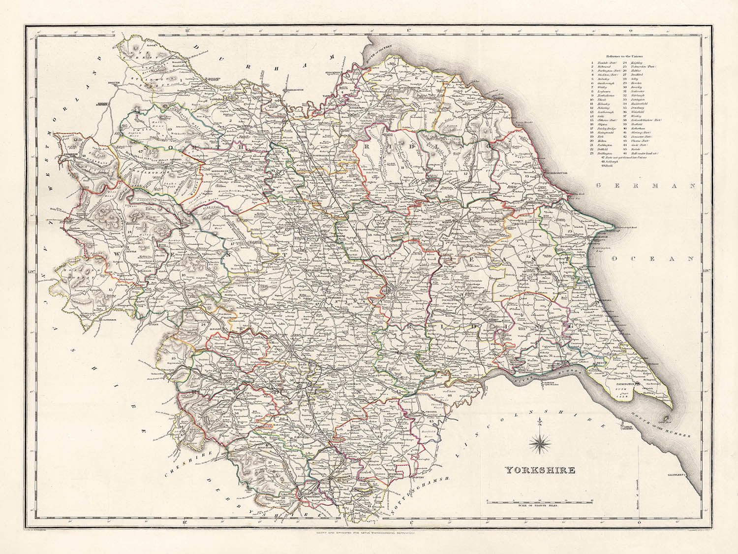


Alte Karte von Yorkshire von Samuel Lewis, 1844: Leeds, Sheffield, Bradford, Kingston upon Hull und York
- All taxes and duties included
- Handmade & dispatched in 1-2 days
-
90 day money back guarantee
ⓘ
90 Tage für Rückgabe und Rückerstattung
Produkte können innerhalb von 90 Tagen für eine vollständige Rückerstattung oder einen Umtausch gegen ein anderes Produkt zurückgegeben werden.
Für personalisierte und maßgefertigte Artikel können wir Ihnen möglicherweise einen Gutschein oder eine nicht ablaufende Geschenkkarte anbieten, da wir personalisierte Bestellungen nicht weiterverkaufen können.
Wenn Sie Fragen haben, kontaktieren Sie uns. Für weitere Informationen siehe unsere vollständige Rückgabe- und Umtauschrichtlinie.

My maps are rare, museum-grade, restored old maps sourced from libraries, auction houses and private collections across the globe.
Framing & free personalisation available
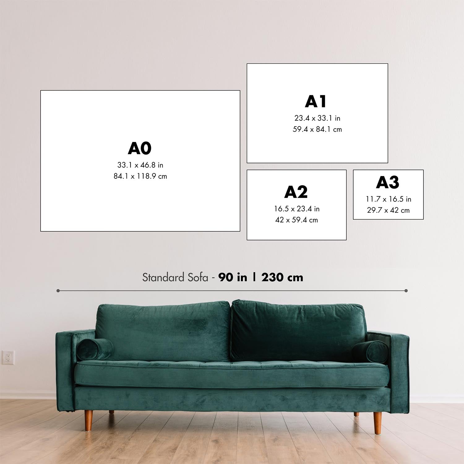
1. Select your size
2. Frame & personalise your map
Make your map unique with framing, hand-drawn customisation, vintage ageing, pop art text, unique 3D styling and moreGeschenkmitteilung & individuelle Ausführung

Wenn Sie eine Geschenkmitteilung oder eine Ausführung (Puzzle, Aluminiumplatte usw.) hinzufügen möchten, die hier nicht verfügbar ist, geben Sie dies bitte in der "Bestellnotiz" beim Checkout an.
Jede Bestellung wird individuell angefertigt. Wenn Sie die Größe leicht anpassen oder auf einem ungewöhnlichen Material drucken lassen möchten, lassen Sie es uns einfach wissen. Wir haben im Laufe der Jahre Tausende von individuellen Bestellungen bearbeitet, daher gibt es (fast) nichts, was wir nicht bewältigen können.
Sie können uns auch kontaktieren, bevor Sie bestellen, wenn Sie möchten!

- Handmade locally. No import duty or tax
- FREE Delivery. Arrives in 2-3 days
- Love it or your money back
- Questions? WhatsApp me any time
Own a piece of history
5,000+ 5 star reviews


Gehen Sie zurück in die Zeit mit dieser atemberaubenden, akribisch detaillierten Karte von Yorkshire aus dem Jahr 1844, die von dem angesehenen Kartografen Samuel Lewis erstellt wurde. Dieses Kunstwerk zeigt akribisch die historischen Grafschaftsgrenzen von Yorkshire in einer Zeit, in der viele seiner Städte und Gemeinden in den frühen Phasen ihres industriellen Aufstiegs waren. Es ist ein Fenster in eine vergangene Ära, in der einige moderne Städte möglicherweise noch nicht existiert haben oder unter einem anderen Namen existierten, was eine faszinierende Erzählung über die Entwicklung dieser historisch reichen Region bietet.
Dieses beeindruckende Stück hat nicht nur immense historische Bedeutung, sondern dient auch als hervorragender Gesprächsstoff. Ob es um die tiefgreifende Transformation von Leeds von einer bescheidenen Marktbürgergemeinde zu einer pulsierenden Industriestadt oder um den anhaltenden Charme von York geht, diese Karte bietet faszinierende Einblicke in die Vergangenheit von Yorkshire. Sie ist ein perfektes Stück für Historiker, Kartografen oder jeden, der sich für das reiche Gefüge der Geschichte von Yorkshire interessiert. Die zeitlose Ästhetik der Karte macht sie zu einer ausgezeichneten Ergänzung für jede Einrichtung.
Bemerkenswerte Städte und Gemeinden:- Leeds (5. Jahrhundert): Leeds war im 13. Jahrhundert eine kleine herrschaftliche Gemeinde, und in den folgenden Jahrhunderten expandierte es und entwickelte sich zu einem wichtigen Zentrum für die Produktion und den Handel mit Wolle.
- Sheffield (ca. 8. Jahrhundert): Bekannt für seine bedeutende Rolle in der Industriellen Revolution, begann Sheffield als kleines Dorf rund um das Sheffield Castle.
- Bradford (Mittelalter): Bradford wuchs im 19. Jahrhundert schnell zu einem internationalen Zentrum der Textilherstellung, insbesondere von Wolle.
- Kingston upon Hull (12. Jahrhundert): Gegründet von Edward I, war Hull ein Marktflecken, Militärversorgungsport, Handelszentrum und industrielle Metropole.
- York (71 n. Chr.): Gegründet von den Römern als Eboracum, war York die Hauptstadt der römischen Provinz Britannia Inferior.
- Wakefield (Wakefield-Charta von 1203): Wakefield wurde im Mittelalter als "Merrie City" bezeichnet und war historisch die Hauptstadt des West Riding von Yorkshire.
- Doncaster (1. Jahrhundert n. Chr.): Ursprünglich ein besetztes römisches Fort namens Danum, war Doncaster schon lange ein wohlhabendes Gebiet aufgrund seiner strategischen Bedeutung am Fluss Don.
- Rotherham (9. Jahrhundert): Im Mittelalter war Rotherham ein wichtiges Zentrum der Eisenindustrie und wurde später zu einem der Hauptkohlenfelder im südlichen Yorkshire.
- Halifax (12. Jahrhundert): Halifax ist bekannt für seine reiche Geschichte in der Wollindustrie, seine beeindruckende viktorianische Architektur und die einzigartige Piece Hall.
- Barnsley (Mittelalter): Barnsley wurde zu einem Zentrum für die Leinenproduktion in England, unterstützt durch den Zugang zu Kohle und Eisen.
- Huddersfield (1066): Huddersfield war ein Marktflecken, bekannt für seine Rolle in der Industriellen Revolution und als Geburtsort des Rugby League.
- Harrogate (16. Jahrhundert): Ein beliebtes Touristenziel und Kurstadt, deren Quellen im 16. Jahrhundert entdeckt wurden.
- Scarborough (966 n. Chr.): Diese historische Kurstadt an der Nordseeküste ist das erste Seebad Großbritanniens.
- Batley (Spätes Mittelalter): Während der Industriellen Revolution war Batley eines der führenden Zentren für Shoddy und Mungo, billigen Stoff, der aus recycelten oder zerrissenen Wollfetzen hergestellt wurde.
- Keighley (Mittelalter): Die Mühlen von Keighley produzierten Textilien zur Ausrüstung von Soldaten und trugen erheblich zur Kriegsanstrengung während der Napoleonischen Kriege bei.
- Castleford (Römische Zeit): Die Geschichte von Castleford reicht bis in die römische Zeit zurück, als es Lagentium genannt wurde.
- Yorkshire Dales Nationalpark: Der 1954 gegründete Park ist berühmt für seine atemberaubenden Landschaften, reiches kulturelles Erbe und vielfältige Tierwelt.
- Die North York Moors: Ein Nationalpark mit einer der größten Flächen von Heidekrautmoor in Großbritannien.
- Fluss Ouse und Fluss Aire: Zwei große Flüsse, die durch Yorkshire fließen, mit malerischen Wegen und viel Tierwelt.
- Ilkley Moor: Bekannt für seinen Hochlandlebensraum und archäologische Überreste, ist es ein beliebtes Ziel zum Wandern und Klettern.
- Flamborough Head: Eines der spektakulärsten Gebiete mit Kreidefelsen in Großbritannien, es beherbergt eine der größten Brutstätten für Seevögel.
- Der Krieg von 1812 (1812-1815): Dieser Konflikt betraf viele Soldaten aus Yorkshire, darunter Regimenter aus Hull und Halifax.
- Luddite-Aufstände (1811-1816): Gefechte zwischen der britischen Armee und Arbeitern, die gegen den Einsatz von Maschinen in der Woll- und Baumwollindustrie protestierten.
- Eröffnung des Leeds und Liverpool Kanals (1816): Diese wichtige Verkehrsroute brachte einen wirtschaftlichen Aufschwung für die Städte entlang ihres Weges.
- Gründung des Yorkshire County Cricket Club (1863): Gegründet am 8. Januar, ist er seitdem einer der erfolgreichsten Cricket-Clubs in England geworden.
- Der Great Reform Act (1832): Viele Städte in Yorkshire, darunter Leeds und Sheffield, erhielten aufgrund dieses Gesetzes einen Sitz im Parlament.
- Gründung von Middlesbrough (1830): Middlesbrough war ein Bauernhof, der sich aufgrund der Kohle- und Eisenindustrie in einen industriellen Giganten verwandelte.
Bitte überprüfen Sie die Bilder, um sicherzustellen, dass eine bestimmte Stadt oder ein bestimmter Ort auf dieser Karte angezeigt wird. Sie können uns auch kontaktieren und darum bitten, die Karte für Sie zu überprüfen.
Ich kann schöne, große Drucke dieser Karte bis zu 50in (127cm) erstellen. Bitte nehmen Sie Kontakt auf, wenn Sie nach größeren, maßgeschneiderten oder anderen Rahmenoptionen suchen.
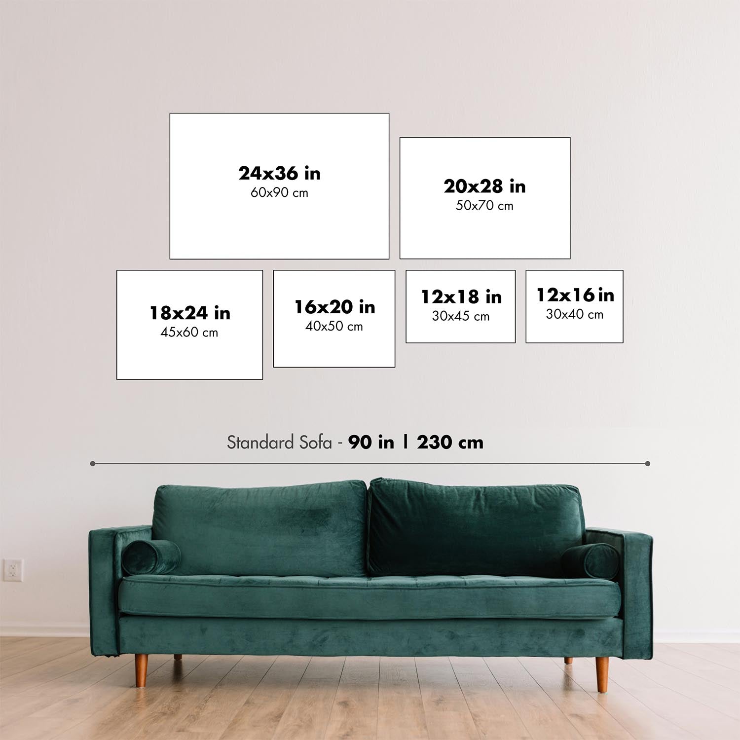
Das Modell auf den Listing-Bildern hält die 18x24in (45,5x61cm) Version dieser Karte.
Das fünfte Listing-Bild zeigt ein Beispiel meines Personalisierungsservices für Karten.
Die Beschriftungen auf dieser Karte sind bei 12x16in (30,5x41cm) sehr klein. Die Karte ist immer noch sehr attraktiv, aber Sie könnten Schwierigkeiten haben, die kleinsten Buchstaben zu lesen. Bitte kaufen Sie eine größere Karte, wenn es wichtig ist, die Karte leicht lesen zu können.
Wenn Sie nach etwas leicht anderem suchen, schauen Sie sich meine Haupt-Sammlung von Karten des Vereinigten Königreichs und Irlands an.
Bitte kontaktieren Sie mich, um zu überprüfen, ob ein bestimmter Ort, Wahrzeichen oder Merkmal auf dieser Karte dargestellt ist.
Dies wäre ein wunderbares Geburtstags-, Weihnachts-, Vatertags-, Abschieds-, Jubiläums- oder Einweihungsgeschenk für jemanden aus den in dieser Karte abgedeckten Gebieten.
Diese Karte ist als Giclée-Druck auf säurefreiem, archivfestem mattem Papier erhältlich, oder Sie können sie gerahmt kaufen. Der Rahmen ist ein schöner, einfacher schwarzer Rahmen, der zu den meisten Ästhetiken passt. Bitte nehmen Sie Kontakt auf, wenn Sie eine andere Rahmenfarbe oder -material wünschen. Meine Rahmen sind mit superklarem, museumsgleichem Acryl (Plexiglas/Acryllit) verglast, das deutlich weniger reflektierend als Glas ist, sicherer ist und immer in perfektem Zustand ankommt.
This map is also available as a float framed canvas, sometimes known as a shadow gap framed canvas or canvas floater. The map is printed on artist's cotton canvas and then stretched over a handmade box frame. We then "float" the canvas inside a wooden frame, which is available in a range of colours (black, dark brown, oak, antique gold and white). This is a wonderful way to present a map without glazing in front. See some examples of float framed canvas maps and explore the differences between my different finishes.
For something truly unique, this map is also available in "Unique 3D", our trademarked process that dramatically transforms the map so that it has a wonderful sense of depth. We combine the original map with detailed topography and elevation data, so that mountains and the terrain really "pop". For more info and examples of 3D maps, check my Unique 3D page.
Für die meisten Bestellungen beträgt die Lieferzeit etwa 3 Werktage. Personalisierte und maßgeschneiderte Produkte benötigen länger, da ich die Personalisierung durchführen und sie Ihnen zur Genehmigung zusenden muss, was normalerweise 1 oder 2 Tage dauert.
Bitte beachten Sie, dass sehr große gerahmte Bestellungen in der Regel länger für die Herstellung und Lieferung benötigen.
Wenn Sie möchten, dass Ihre Bestellung bis zu einem bestimmten Datum ankommt, bitte kontaktieren Sie mich, bevor Sie bestellen, damit wir den besten Weg finden können, um sicherzustellen, dass Sie Ihre Bestellung rechtzeitig erhalten.
Ich drucke und rahme Karten und Kunstwerke in 23 Ländern weltweit. Das bedeutet, dass Ihre Bestellung lokal gefertigt wird, was die Lieferzeit verkürzt und sicherstellt, dass sie während der Lieferung nicht beschädigt wird. Sie zahlen nie Zoll oder Einfuhrgebühren, und wir stoßen weniger CO2 in die Luft aus.
Alle meine Karten und Kunstdrucke sind gut verpackt und werden in einem robusten Rohr versendet, wenn sie ungerahmt sind, oder von Schaum umgeben, wenn sie gerahmt sind.
Ich versuche, alle Bestellungen innerhalb von 1 oder 2 Tagen nach Erhalt Ihrer Bestellung zu versenden, obwohl einige Produkte (wie Gesichtsmasken, Tassen und Tragetaschen) länger zur Herstellung benötigen können.
Wenn Sie Express-Lieferung an der Kasse auswählen, priorisieren wir Ihre Bestellung und versenden sie per 1-Tages-Kurier (Fedex, DHL, UPS, Parcelforce).
Nächster Tag Lieferung ist auch in einigen Ländern verfügbar (USA, UK, Singapur, VAE), aber bitte versuchen Sie, früh am Tag zu bestellen, damit wir es rechtzeitig versenden können.
Lesen Sie meinen vollständigen Leitfaden zur Lieferung und lokalen Produktion
Mein Standardrahmen ist ein Galerie-Stil-Rahmen aus schwarzem Eschenholz. Er ist einfach und sieht ziemlich modern aus. Mein Standardrahmen ist etwa 20 mm (0,8 Zoll) breit.
Ich verwende super-klares Acryl (Plexiglas/Acrylt) für das Glas des Rahmens. Es ist leichter und sicherer als Glas – und es sieht besser aus, da die Reflexion geringer ist.
Sechs Standardrahmenfarben sind kostenlos erhältlich (schwarz, dunkelbraun, dunkelgrau, Eiche, weiß und antikgold).
Die meisten Karten, Kunstwerke und Illustrationen sind auch als gerahmte Leinwand erhältlich. Wir verwenden matte (nicht glänzende) Baumwollleinwand, spannen sie über einen nachhaltig beschafften Buchenrahmen und 'schweben' dann das Stück innerhalb eines Holzrahmens. Das Endergebnis ist ziemlich schön, und es gibt keine Verglasung, die im Weg ist.
Alle Rahmen werden "bereit zum Aufhängen" geliefert, entweder mit einer Schnur oder Halterungen auf der Rückseite. Sehr große Rahmen haben schwere Aufhängeplatten und/oder eine Montageschiene. Wenn Sie Fragen haben, können Sie bitte Kontakt aufnehmen.
Sehen Sie sich einige Beispiele meiner gerahmten Karten und gerahmten Leinwandkarten an.
Alternativ kann ich auch alte Karten und Kunstwerke auf Leinwand, Schaumstoffplatten, Baumwollrag und andere Materialien liefern.
Wenn Sie Ihre Karte oder Ihr Kunstwerk selbst rahmen möchten, lesen Sie bitte zuerst meinen Größenleitfaden.
Einige meiner alten Karten sind jetzt als gerahmte Leinwände erhältlich. Bitte kontaktiere mich, wenn du eine Größe bestellen möchtest, die in meinem Shop nicht verfügbar ist.
Leinwand alte Karten sind eine interessante Alternative zu konventionell gerahmten Karten. Je nach deinem persönlichen Geschmack und der Raumdekoration können Leinwandkarten etwas mehr „herausstechen“ als eine gerahmte Karte.
Meine Karten sind äußerst hochwertige Reproduktionen von Originalkarten.
Ich beziehe originale, seltene Karten aus Bibliotheken, Auktionshäusern und Privatsammlungen auf der ganzen Welt, restauriere sie in meiner Londoner Werkstatt und erstelle dann mit speziellen Giclée-Tinten und -Druckern wunderschöne Karten, die sogar noch besser aussehen als das Original.
Meine Karten werden auf säurefreiem, mattem Archivpapier (nicht glänzend) gedruckt, das sich sehr hochwertig anfühlt und fast wie Karton aussieht. Technisch gesehen beträgt das Papiergewicht/die Papierdicke 10mil/200g/m². Es eignet sich perfekt zum Einrahmen.
Ich drucke mit UV-lichtbeständigen Ultrachrome-Giclée-Pigmenttinten von Epson – einige der besten Tinten, die Sie finden können.
Ich kann auch machen Karten auf Leinwand, Baumwolllappen und andere exotische Materialien.
Erfahren Sie mehr über The Unique Maps Co.
Kartenpersonalisierung
Wenn Sie nach dem perfekten Geschenk zum Jahrestag oder zur Einweihung suchen, kann ich Ihre Karte personalisieren, um sie wirklich einzigartig zu machen. Ich kann beispielsweise eine kurze Nachricht hinzufügen, einen wichtigen Ort hervorheben oder das Wappen Ihrer Familie hinzufügen.
Die Möglichkeiten sind nahezu unbegrenzt. Bitte sehen Sie sich meine Kartenpersonalisierungsseite für einige wunderbare Beispiele dessen, was möglich ist.
Um eine personalisierte Karte zu bestellen, wählen Sie „Personalisieren Sie Ihre Karte“, bevor Sie sie in den Warenkorb legen.
In Kontakt kommen wenn Sie nach komplexeren Anpassungen und Personalisierungen suchen.
Kartenalterung
Im Laufe der Jahre wurde ich von Kunden hunderte Male gefragt, ob sie eine Karte kaufen könnten, die noch älter.
Nun, jetzt können Sie das, indem Sie „Alter“ auswählen, bevor Sie eine Karte in Ihren Warenkorb legen.
Alle Produktfotos, die Sie auf dieser Seite sehen, zeigen die Karte in ihrer Originalform. So sieht die Karte heute aus.
Wenn Sie „Gealtert“ auswählen, werde ich Ihre Karte von Hand altern lassen. Dazu verwende ich ein spezielles und einzigartiges Verfahren, das ich durch jahrelanges Studium alter Karten und Gespräche mit Forschern zum Verständnis der Chemie alternder Papiere entwickelt habe, und natürlich ... viel Übung!
Wenn Sie sich nicht sicher sind, bleiben Sie bei der Originalfarbe der Karte. Wenn Sie etwas Dunkleres und älter Wenn Sie auf der Suche sind, entscheiden Sie sich für „Aged“.
Sehen Sie einige erstaunliche Beispiele für gealterte Karten.
Wenn Sie aus irgendeinem Grund mit Ihrer Bestellung nicht zufrieden sind, kontaktieren Sie mich für eine unkomplizierte Rückerstattung. Bitte sehen Sie sich unsere Rückgabe- und Rückerstattungsrichtlinien für weitere Informationen an.
Ich bin sehr zuversichtlich, dass Ihnen Ihre restaurierte Karte oder Kunstdruck gefallen wird. Ich mache das seit 1984. Ich bin ein 5-Sterne Etsy-Verkäufer. Ich habe Zehntausende von Karten und Kunstdrucken verkauft und habe über 5.000 echte 5-Sterne-Bewertungen.
Ich verwende einen einzigartigen Prozess, um Karten und Kunstwerke zu restaurieren, der extrem zeitaufwendig und arbeitsintensiv ist. Die Suche nach den Originalkarten und Illustrationen kann Monate dauern. Ich benutze modernste und unglaublich teure Technologie, um sie zu scannen und wiederherzustellen. Daher garantiere ich, dass meine Karten und Kunstdrucke eine Klasse für sich sind - deshalb kann ich eine unkomplizierte Rückerstattung anbieten.
Fast alle meine Karten und Kunstdrucke sehen in großen Größen (200 cm, 6,5 Fuß+) erstaunlich aus und ich kann sie Ihnen auch gerahmt und über einen speziellen Übergrößen-Kurier liefern. Kontaktieren Sie mich, um Ihre speziellen Bedürfnisse zu besprechen.
Or try searching for something!


