

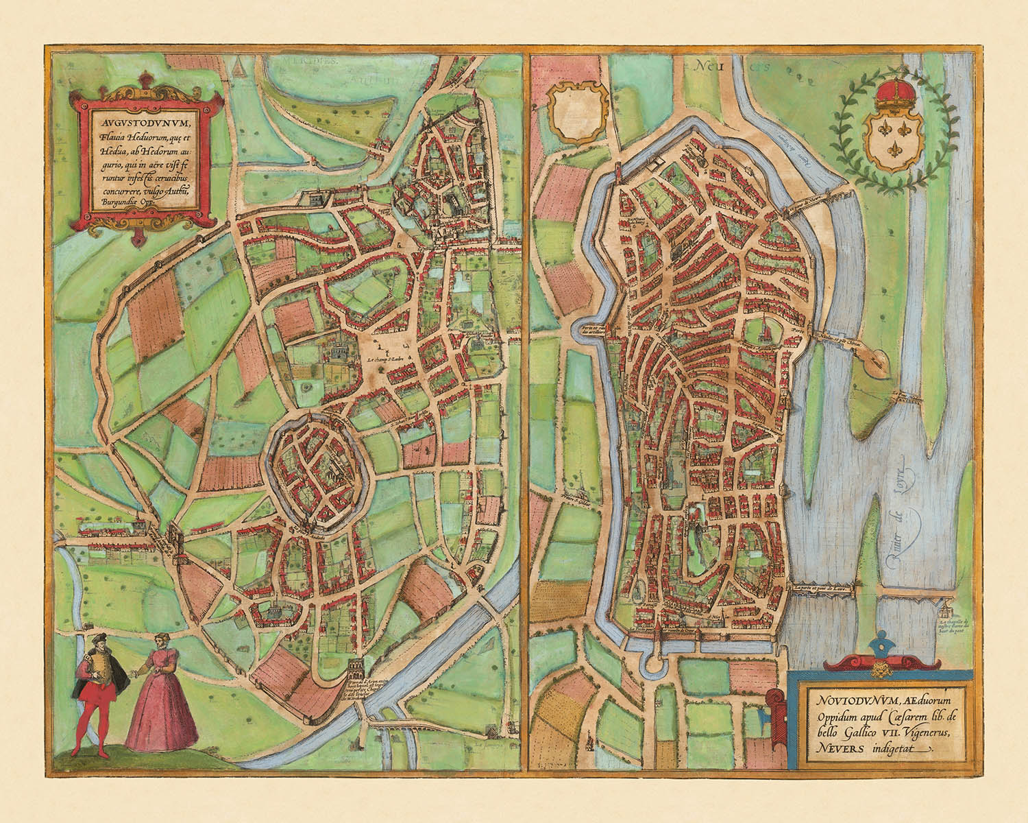


Alte Karte von Autun & Nevers von Braun & Hogenberg, 1581: Stadtmauern, Kathedralen, Herzogspalast, Loire- und Arroux-Flüsse, Brücken
Lieferung zum Vatertag
Das kostenlose Lieferfenster für den Vatertag ist fast abgelaufen. Bestellungen, die heute mit kostenloser Lieferung aufgegeben werden, können rechtzeitig ankommen.
Expresslieferung ist an der Kasse für eine Lieferung in 1–2 Tagen verfügbar, und in einigen Ländern ist bei Bestellungen vor 10 Uhr auch eine Lieferung am nächsten Tag möglich.
Personalisierte Bestellungen können etwas länger dauern, da wir vor der Fertigung und dem Versand Ihrer Bestellung einen Design-Proof zu Ihrer Freigabe erstellen.
Nach Ihrer Bestellung können Sie dem Empfänger eine schöne digitale Geschenkvorschau senden. Das ist ideal, wenn Sie befürchten, dass die Bestellung nicht rechtzeitig zum Vatertag ankommt.
Bitte bestellen Sie so bald wie möglich, um die besten Chancen auf eine rechtzeitige Lieferung zum Vatertag zu haben.
Kontaktieren Sie uns, wenn Sie Hilfe bei der Wahl der schnellsten Option wünschen.

Choose your size
Choose your finish


(Mehr Infos)
Geschenkmitteilung & individuelle Ausführung

Wenn Sie eine Geschenkmitteilung oder eine Ausführung (Puzzle, Aluminiumplatte usw.) hinzufügen möchten, die hier nicht verfügbar ist, geben Sie dies bitte in der "Bestellnotiz" beim Checkout an.
Jede Bestellung wird individuell angefertigt. Wenn Sie die Größe leicht anpassen oder auf einem ungewöhnlichen Material drucken lassen möchten, lassen Sie es uns einfach wissen. Wir haben im Laufe der Jahre Tausende von individuellen Bestellungen bearbeitet, daher gibt es (fast) nichts, was wir nicht bewältigen können.
Sie können uns auch kontaktieren, bevor Sie bestellen, wenn Sie möchten!

- Made locally for fast, safe delivery
- No import duty or hidden fees
- Need advice? Message us on WhatsApp
Own a piece of history
7,000+ 5 star reviews


Betreten Sie die Welt des späten Renaissance-Frankreichs mit dieser exquisiten Stadtkarte mit dem Titel "[Autun und Nevers] Augustodunum, Flavia Heduorum, que et Hedua, ab Hedorum augurio . . . / Noviodunum, Aeduorum Oppidum apud Casearem lib. de bello Gallico VII Vigenerus, Nevers indigetat." Diese Karte, die 1581 von dem gefeierten Duo Georg Braun und Frans Hogenberg erstellt wurde, ist ein seltener und erhellender Blick in das urbane Herz Burgunds. Der ursprüngliche lateinische Titel, der in klassischen und gallischen Referenzen getränkt ist, signalisiert sofort die historische Tiefe und Bedeutung der dargestellten Städte – Autun (Augustodunum) und Nevers (Noviodunum) – die beide eine prominente Rolle in der römischen und mittelalterlichen französischen Geschichte spielten.
Was diese Karte auszeichnet, ist ihre atemberaubende Vogelperspektive, ein Markenzeichen der Kunst von Braun & Hogenberg. Die ummauerten Städte Autun und Nevers sind mit akribischer Aufmerksamkeit für ihre Befestigungen dargestellt, was die defensiven Prioritäten der Epoche offenbart. Die Karte fängt die komplexe Geometrie der Stadtmauern, Bastionen und Tore ein, die alle in eine grüne Landschaft eingebettet sind. Fließende Flüsse – der Arroux bei Autun und die majestätische Loire bei Nevers – schlängeln sich durch die Landschaft, ihre Steinbrücken verbinden das geschäftige Stadtleben mit den fruchtbaren Feldern jenseits.
Innerhalb der Stadtmauern treten bedeutende Wahrzeichen in den Vordergrund. In Autun dominiert die grandiose Kathedrale Saint-Lazare die Skyline, ihre romanischen Türme sind ein Zeugnis des kirchlichen Erbes der Stadt. Auch Nevers kann mit seiner imposanten Kathedrale und dem befestigten Herzogspalast aufwarten, deren Strukturen sorgfältig illustriert sind, um ihre architektonische Gravitas zu vermitteln. Dekorative Kartuschen und Wappen schmücken die Komposition und unterstreichen den bürgerlichen Stolz und die edle Abstammung dieser historischen Zentren.
Diese Karte ist nicht nur ein Verzeichnis von Straßen und Gebäuden; sie ist eine Feier der urbanen Identität und des kartografischen Fortschritts der Renaissance. Figuren in zeitgenössischer Kleidung beleben den Vordergrund und bieten einen Einblick in das tägliche Leben und das soziale Gefüge des 16. Jahrhunderts. Die umliegende Landschaft, gespickt mit ländlichen Häusern und offenen Feldern, bietet einen dramatischen Kontrast zu den dichten urbanen Kernen und hebt das Zusammenspiel zwischen Stadt und Umland hervor, das den Wohlstand der Region prägte.
Die historische Bedeutung dieser Karte wird durch ihre Aufnahme in das legendäre Civitates Orbis Terrarum, den sechsbändigen Atlas, der den Standard für die Stadtkartierung im frühneuzeitlichen Europa setzte, verstärkt. Die Zusammenarbeit von Braun & Hogenberg produzierte einige der einflussreichsten Stadtansichten ihrer Zeit, und diese Karte von Autun und Nevers steht als Zeugnis ihrer Vision. Sie ist eine wesentliche Erwerbung für Sammler und Kenner, die die Verschmelzung von Kunst, Geschichte und urbaner Geografie zu Beginn der modernen Zeit schätzen.
Bemerkenswerte Merkmale & Wahrzeichen
- Zwei Hauptstadtansichten: Autun (Augustodunum) und Nevers (Noviodunum), jeweils detailliert dargestellt.
- Stadtmauern und Befestigungen, die sowohl Autun als auch Nevers umgeben.
- Flüsse, die durch oder in der Nähe beider Städte fließen (der Arroux für Autun und die Loire für Nevers).
- Prominente Kathedralen oder Kirchen, die in beiden Städten sichtbar sind (insbesondere die Kathedrale Saint-Lazare in Autun und die Kathedrale von Nevers).
- Burgen oder befestigte Strukturen innerhalb oder angrenzend an die Stadtmauern.
- Brücken, die die Flüsse in der Nähe der Städte überqueren.
- Offene Landschaft, Felder und ländliche Gebäude, die die urbanen Zentren umgeben.
- Dekorative Kartuschen mit lateinischen Titeln und beschreibendem Text.
Historischer und gestalterischer Kontext
- Name der Karte: [Autun und Nevers] Augustodunum, Flavia Heduorum, que et Hedua, ab Hedorum augurio . . . / Noviodunum, Aeduorum Oppidum apud Casearem lib. de bello Gallico VII Vigenerus, Nevers indigetat.
- Dies ist ein bemerkenswertes Beispiel für frühe Stadtpläne von Autun und Nevers, die in Braun & Hogenbergs monumentalem 6-bändigen Werk, Civitates Orbis Terrarum, enthalten sind, das einer der frühesten umfassenden Atlanten von Stadtansichten und Karten war.
- Erstellungsdatum: 1581.
- Kartenmacher/Verleger: Georg Braun & Frans Hogenberg, bekannt für ihre Zusammenarbeit an den Civitates Orbis Terrarum (veröffentlicht 1572–1617), einem wegweisenden Atlas, der Städte in ganz Europa und darüber hinaus darstellte.
- Die Karte zeigt vogelperspektivische Darstellungen der Städte Autun und Nevers (im heutigen Frankreich), mit Fokus auf Stadtlayout, Befestigungen und bedeutenden Gebäuden.
- Die Karte ist eine Stadtansicht aus der Vogelperspektive, typisch für die europäische Kartographie des späten 16. Jahrhunderts, mit detaillierten Illustrationen von Gebäuden, Befestigungen, Flüssen und der umliegenden Landschaft.
- Die Karte bietet wertvolle Einblicke in die städtische Form, Architektur und Verteidigungsstrukturen französischer Städte der späten Renaissance. Sie ist auch bedeutend als Teil der Civitates Orbis Terrarum, die das europäische Verständnis von Städten und Stadtgeographie in dieser Zeit prägte.
Bitte überprüfen Sie die Bilder, um sicherzustellen, dass eine bestimmte Stadt oder ein Ort auf dieser Karte dargestellt ist. Sie können uns auch kontaktieren und bitten, die Karte für Sie zu überprüfen.
Diese Karte sieht in jeder Größe großartig aus, aber ich empfehle immer, eine größere Größe zu wählen, wenn Sie Platz haben. So können Sie alle Details leicht erkennen.
Diese Karte sieht bis zu 70 Zoll (180 cm) fantastisch aus. Wenn Sie nach einer größeren Karte suchen, bitte kontaktieren Sie uns.
Das Modell in den Angebotsbildern hält die 16x20 Zoll (40x50 cm) Version dieser Karte.
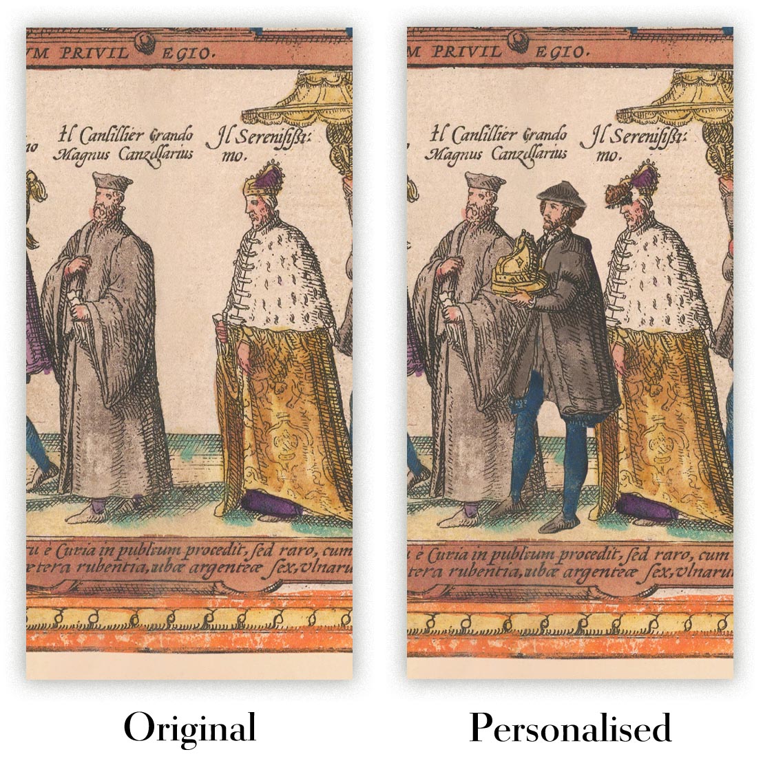
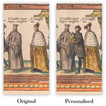
Das fünfte Angebotsbild zeigt ein Beispiel für meinen Personalisierungsservice für Karten.
Wenn Sie nach etwas leicht anderem suchen, schauen Sie sich meine Sammlung der besten alten Karten an, um zu sehen, ob etwas anderes Ihr Interesse weckt.
Bitte kontaktieren Sie mich, um zu überprüfen, ob ein bestimmter Standort, Wahrzeichen oder Merkmal auf dieser Karte dargestellt ist.
Dies wäre ein wunderbares Geschenk zum Geburtstag, zu Weihnachten, zum Vatertag, zum Abschied von der Arbeit, zum Jubiläum oder zur Einweihung für jemanden aus den Gebieten, die von dieser Karte abgedeckt werden.
Diese Karte ist als Giclée-Druck auf säurefreiem, archiviertem mattem Papier erhältlich, oder Sie können sie gerahmt kaufen. Der Rahmen ist ein schöner, einfacher schwarzer Rahmen, der zu den meisten Ästhetiken passt. Bitte kontaktieren Sie mich, wenn Sie eine andere Rahmenfarbe oder -material wünschen. Meine Rahmen sind mit superklarem museumsglanzendem Acryl (Plexiglas/Acrylt) beschichtet, das deutlich weniger reflektierend ist als Glas, sicherer und immer in perfektem Zustand ankommt.
This map is also available as a float framed canvas, sometimes known as a shadow gap framed canvas or canvas floater. The map is printed on artist's cotton canvas and then stretched over a handmade box frame. We then "float" the canvas inside a wooden frame, which is available in a range of colours (black, dark brown, oak, antique gold and white). This is a wonderful way to present a map without glazing in front. See some examples of float framed canvas maps and explore the differences between my different finishes.
For something truly unique, this map is also available in "Unique 3D", our trademarked process that dramatically transforms the map so that it has a wonderful sense of depth. We combine the original map with detailed topography and elevation data, so that mountains and the terrain really "pop". For more info and examples of 3D maps, check my Unique 3D page.
Many of our maps and art prints are chosen as thoughtful gifts for homes, offices, studies and meaningful places.
Choose a framed option for the easiest ready-to-hang gift, or choose an unframed print if the recipient may prefer to select their own frame.
We make orders locally in 23 countries around the world, so gifts can often be produced close to the recipient. This helps them arrive faster, travel more safely, and avoid customs or import duty surprises.
- We can deliver directly to the recipient
- Framed pieces arrive ready to hang
- Unframed prints are carefully packed in a strong protective tube
- Almost every order is made locally, for faster, safer gifting
- 90-day returns give the recipient time to decide
If you are not sure what to choose, please contact us. We can help you pick the right map, size, finish or delivery option.
Für die meisten Bestellungen beträgt die Lieferzeit etwa 3 Werktage. Personalisierte und maßgeschneiderte Produkte benötigen länger, da ich die Personalisierung durchführen und sie Ihnen zur Genehmigung zusenden muss, was normalerweise 1 oder 2 Tage dauert.
Bitte beachten Sie, dass sehr große gerahmte Bestellungen in der Regel länger für die Herstellung und Lieferung benötigen.
Wenn Sie möchten, dass Ihre Bestellung bis zu einem bestimmten Datum ankommt, bitte kontaktieren Sie mich, bevor Sie bestellen, damit wir den besten Weg finden können, um sicherzustellen, dass Sie Ihre Bestellung rechtzeitig erhalten.
Ich drucke und rahme Karten und Kunstwerke in 23 Ländern weltweit. Das bedeutet, dass Ihre Bestellung lokal gefertigt wird, was die Lieferzeit verkürzt und sicherstellt, dass sie während der Lieferung nicht beschädigt wird. Sie zahlen nie Zoll oder Einfuhrgebühren, und wir stoßen weniger CO2 in die Luft aus.
Alle meine Karten und Kunstdrucke sind gut verpackt und werden in einem robusten Rohr versendet, wenn sie ungerahmt sind, oder von Schaum umgeben, wenn sie gerahmt sind.
Ich versuche, alle Bestellungen innerhalb von 1 oder 2 Tagen nach Erhalt Ihrer Bestellung zu versenden, obwohl einige Produkte (wie Gesichtsmasken, Tassen und Tragetaschen) länger zur Herstellung benötigen können.
Wenn Sie Express-Lieferung an der Kasse auswählen, priorisieren wir Ihre Bestellung und versenden sie per 1-Tages-Kurier (Fedex, DHL, UPS, Parcelforce).
Nächster Tag Lieferung ist auch in einigen Ländern verfügbar (USA, UK, Singapur, VAE), aber bitte versuchen Sie, früh am Tag zu bestellen, damit wir es rechtzeitig versenden können.
Lesen Sie meinen vollständigen Leitfaden zur Lieferung und lokalen Produktion
Mein Standardrahmen ist ein Galerie-Stil-Rahmen aus schwarzem Eschenholz. Er ist einfach und sieht ziemlich modern aus. Mein Standardrahmen ist etwa 20 mm (0,8 Zoll) breit.
Ich verwende super-klares Acryl (Plexiglas/Acrylt) für das Glas des Rahmens. Es ist leichter und sicherer als Glas – und es sieht besser aus, da die Reflexion geringer ist.
Sechs Standardrahmenfarben sind kostenlos erhältlich (schwarz, dunkelbraun, dunkelgrau, Eiche, weiß und antikgold).
Die meisten Karten, Kunstwerke und Illustrationen sind auch als gerahmte Leinwand erhältlich. Wir verwenden matte (nicht glänzende) Baumwollleinwand, spannen sie über einen nachhaltig beschafften Buchenrahmen und 'schweben' dann das Stück innerhalb eines Holzrahmens. Das Endergebnis ist ziemlich schön, und es gibt keine Verglasung, die im Weg ist.
Alle Rahmen werden "bereit zum Aufhängen" geliefert, entweder mit einer Schnur oder Halterungen auf der Rückseite. Sehr große Rahmen haben schwere Aufhängeplatten und/oder eine Montageschiene. Wenn Sie Fragen haben, können Sie bitte Kontakt aufnehmen.
Sehen Sie sich einige Beispiele meiner gerahmten Karten und gerahmten Leinwandkarten an.
Alternativ kann ich auch alte Karten und Kunstwerke auf Leinwand, Schaumstoffplatten, Baumwollrag und andere Materialien liefern.
Wenn Sie Ihre Karte oder Ihr Kunstwerk selbst rahmen möchten, lesen Sie bitte zuerst meinen Größenleitfaden.
Meine Karten sind äußerst hochwertige Reproduktionen von Originalkarten.
Ich beziehe originale, seltene Karten aus Bibliotheken, Auktionshäusern und Privatsammlungen auf der ganzen Welt, restauriere sie in meiner Londoner Werkstatt und erstelle dann mit speziellen Giclée-Tinten und -Druckern wunderschöne Karten, die sogar noch besser aussehen als das Original.
Meine Karten werden auf säurefreiem, mattem Archivpapier (nicht glänzend) gedruckt, das sich sehr hochwertig anfühlt und fast wie Karton aussieht. Technisch gesehen beträgt das Papiergewicht/die Papierdicke 10mil/200g/m². Es eignet sich perfekt zum Einrahmen.
Ich drucke mit UV-lichtbeständigen Ultrachrome-Giclée-Pigmenttinten von Epson – einige der besten Tinten, die Sie finden können.
Ich kann auch machen Karten auf Leinwand, Baumwolllappen und andere exotische Materialien.
Erfahren Sie mehr über The Unique Maps Co.
Kartenpersonalisierung
Wenn Sie nach dem perfekten Geschenk zum Jahrestag oder zur Einweihung suchen, kann ich Ihre Karte personalisieren, um sie wirklich einzigartig zu machen. Ich kann beispielsweise eine kurze Nachricht hinzufügen, einen wichtigen Ort hervorheben oder das Wappen Ihrer Familie hinzufügen.
Die Möglichkeiten sind nahezu unbegrenzt. Bitte sehen Sie sich meine Kartenpersonalisierungsseite für einige wunderbare Beispiele dessen, was möglich ist.
Um eine personalisierte Karte zu bestellen, wählen Sie „Personalisieren Sie Ihre Karte“, bevor Sie sie in den Warenkorb legen.
In Kontakt kommen wenn Sie nach komplexeren Anpassungen und Personalisierungen suchen.
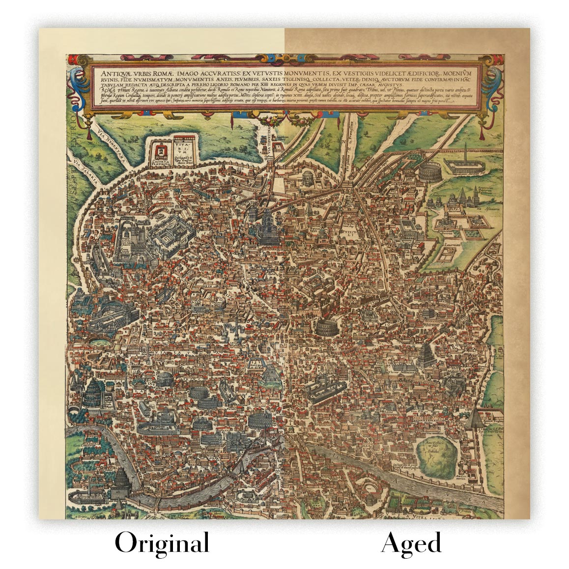
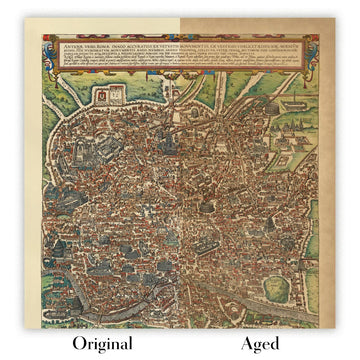
Kartenalterung
Im Laufe der Jahre wurde ich von Kunden hunderte Male gefragt, ob sie eine Karte kaufen könnten, die noch älter.
Nun, jetzt können Sie das, indem Sie „Alter“ auswählen, bevor Sie eine Karte in Ihren Warenkorb legen.
Alle Produktfotos, die Sie auf dieser Seite sehen, zeigen die Karte in ihrer Originalform. So sieht die Karte heute aus.
Wenn Sie „Gealtert“ auswählen, werde ich Ihre Karte von Hand altern lassen. Dazu verwende ich ein spezielles und einzigartiges Verfahren, das ich durch jahrelanges Studium alter Karten und Gespräche mit Forschern zum Verständnis der Chemie alternder Papiere entwickelt habe, und natürlich ... viel Übung!
Wenn Sie sich nicht sicher sind, bleiben Sie bei der Originalfarbe der Karte. Wenn Sie etwas Dunkleres und älter Wenn Sie auf der Suche sind, entscheiden Sie sich für „Aged“.
Sehen Sie einige erstaunliche Beispiele für gealterte Karten.
Wenn Sie aus irgendeinem Grund mit Ihrer Bestellung nicht zufrieden sind, kontaktieren Sie mich für eine unkomplizierte Rückerstattung. Bitte sehen Sie sich unsere Rückgabe- und Rückerstattungsrichtlinien für weitere Informationen an.
Ich bin sehr zuversichtlich, dass Ihnen Ihre restaurierte Karte oder Kunstdruck gefallen wird. Ich mache das seit 1984. Ich bin ein 5-Sterne Etsy-Verkäufer. Ich habe Zehntausende von Karten und Kunstdrucken verkauft und habe über 5.000 echte 5-Sterne-Bewertungen.
Ich verwende einen einzigartigen Prozess, um Karten und Kunstwerke zu restaurieren, der extrem zeitaufwendig und arbeitsintensiv ist. Die Suche nach den Originalkarten und Illustrationen kann Monate dauern. Ich benutze modernste und unglaublich teure Technologie, um sie zu scannen und wiederherzustellen. Daher garantiere ich, dass meine Karten und Kunstdrucke eine Klasse für sich sind - deshalb kann ich eine unkomplizierte Rückerstattung anbieten.
Fast alle meine Karten und Kunstdrucke sehen in großen Größen (200 cm, 6,5 Fuß+) erstaunlich aus und ich kann sie Ihnen auch gerahmt und über einen speziellen Übergrößen-Kurier liefern. Kontaktieren Sie mich, um Ihre speziellen Bedürfnisse zu besprechen.
Or try searching for something!


