


Alte Karte der Kleinen Antillen von Bellin, 1764: Barbados, Martinique, Guadeloupe, Antigua, Jungferninseln
20% Rabatt auf 2 — 33% Rabatt auf 3
Fügen Sie beliebige zwei berechtigte Artikel zu Ihrem Warenkorb hinzu, um 20% Rabatt zu erhalten. Fügen Sie einen dritten hinzu und er ist kostenlos (entspricht 33% Rabatt, wenn Sie drei kaufen).
Kein Code erforderlich — das Angebot wird automatisch an der Kasse angewendet.
Gültig für alle Standardkarten und Kunstdrucke. Sie können beliebige Designs kombinieren.
Wenn Sie Artikel an mehrere Adressen versenden möchten, kontaktieren Sie uns bitte, bevor Sie Ihre Bestellung aufgeben.
Maßanfertigungen und individuelle Aufträge sind ausgeschlossen.
Kontaktieren Sie uns wenn Sie Fragen haben

Choose your size
Choose your finish


(Mehr Infos)
Geschenkmitteilung & individuelle Ausführung

Wenn Sie eine Geschenkmitteilung oder eine Ausführung (Puzzle, Aluminiumplatte usw.) hinzufügen möchten, die hier nicht verfügbar ist, geben Sie dies bitte in der "Bestellnotiz" beim Checkout an.
Jede Bestellung wird individuell angefertigt. Wenn Sie die Größe leicht anpassen oder auf einem ungewöhnlichen Material drucken lassen möchten, lassen Sie es uns einfach wissen. Wir haben im Laufe der Jahre Tausende von individuellen Bestellungen bearbeitet, daher gibt es (fast) nichts, was wir nicht bewältigen können.
Sie können uns auch kontaktieren, bevor Sie bestellen, wenn Sie möchten!

- Made locally for fast, safe delivery
- No import duty or hidden fees
- Need advice? Message us on WhatsApp
Own a piece of history
7,000+ 5 star reviews


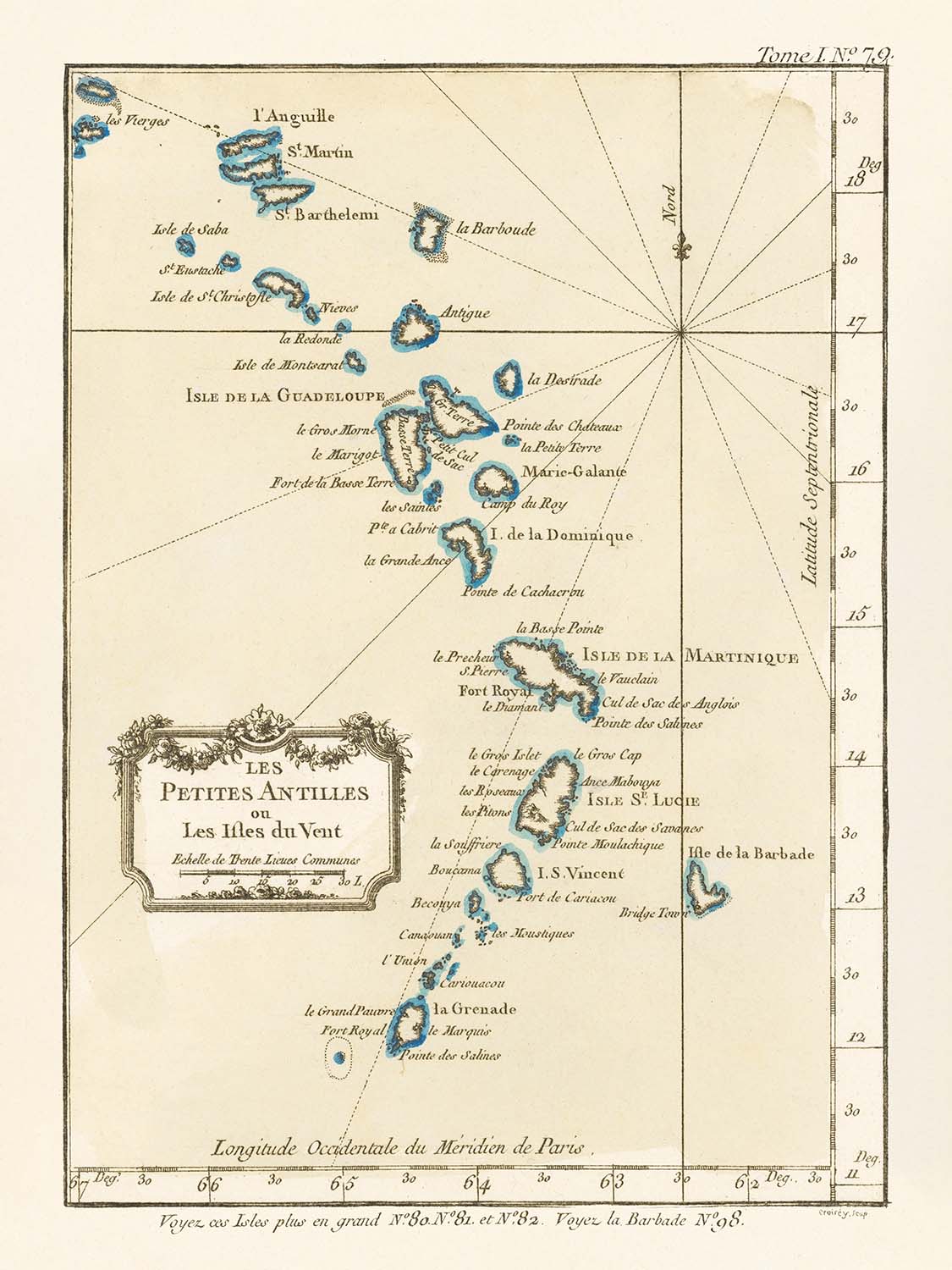
Tauchen Sie ein in die lebendige maritime Welt des 18. Jahrhunderts mit „Les Petites Antilles ou Les Isles du Vent“, einem Meisterwerk des renommierten französischen Kartografen Jacques Nicolas Bellin, datiert auf 1764. Diese außergewöhnliche Karte zeichnet elegant den Bogen der Kleinen Antillen oder Windward Islands nach und erfasst den kritischen Korridor zwischen dem Atlantischen Ozean und der Karibischen See. Bellins akribisches Handwerk zeigt sich in der Klarheit, mit der er jede Insel umreißt, von den geschichtsträchtigen Küsten von Barbados und Grenada im Süden bis zu dem komplexen Cluster der Jungferninseln und Saint Barthélemy im Norden. Der prominent dargestellte ursprüngliche französische Titel beschwört den Geist der Entdeckung dieser Epoche und die strategische Bedeutung dieser Inseln für die europäischen Imperien.
Jacques Nicolas Bellin, Hydrograph für den König von Frankreich und eine führende Figur im Dépôt des cartes et plans de la Marine, wurde für seine Präzision und Aufmerksamkeit für navigational Details gefeiert. Seine Karten, einschließlich dieser, waren unverzichtbare Werkzeuge für Seefahrer, Händler und koloniale Verwalter, die die oft tückischen Gewässer der Karibik befahren. Bellins „Petit Atlas Maritime“, aus dem diese Karte stammt, war ein Grundpfeiler der Kartografie des 18. Jahrhunderts, der wissenschaftliche Strenge mit dem Sinn eines Künstlers für Proportion und Klarheit kombinierte. Diese Karte steht als Zeugnis von Bellins Erbe und spiegelt sowohl die geopolitischen Ambitionen als auch die navigationalen Herausforderungen seiner Zeit wider.
Der Umfang der Karte ist bemerkenswert und umfasst eine Konstellation von Inseln, die heute das Herz der Karibik bilden. Jede Insel ist klar umrissen und beschriftet, darunter Martinique, Guadeloupe, Saint Lucia, Saint Vincent, Dominica, Antigua und mehr. Diese Inseln waren und sind Orte von immensem kulturellem und historischem Bedeutung - Kreuzungen von Handel, Konflikten und Migration. Die sorgfältige Darstellung von Küstenlinien und maritimen Passagen hebt die Rolle der Inseln sowohl als Zufluchtsorte als auch als Gefahren für Schiffe hervor und unterstreicht ihre Bedeutung in den globalen Handelsnetzen dieser Epoche.
Innerhalb der Grenzen der Karte entsteht ein Bild menschlicher Siedlungen. Bellins Karte identifiziert wichtige koloniale Städte und Häfen, die zu den lebhaften Hauptstädten und Wirtschaftszentren der modernen Karibik werden sollten. Erwähnenswert sind unter anderem Bridgetown in Barbados, Saint-Pierre und Fort Royal (heute Fort-de-France) in Martinique, Basse-Terre und Pointe-à-Pitre in Guadeloupe sowie St. John's in Antigua. Diese Städte, die auf der Karte markiert sind, waren wichtige Knotenpunkte im Netz der kolonialen Verwaltung, des Handels und der Kultur, deren Schicksal mit den Gezeiten des Imperiums und des Handels auf- und abging.
Über ihren unmittelbaren Nutzen hinaus bietet „Les Petites Antilles ou Les Isles du Vent“ einen Einblick in die sich verändernde geopolitische Landschaft des 18. Jahrhunderts. Die Klarheit und Detailgenauigkeit der Karte spiegeln den intensiven Wettbewerb zwischen den europäischen Mächten um die Kontrolle über diese Inseln wider, die für ihre strategischen Häfen und fruchtbaren Ländereien geschätzt wurden. Heute ist Bellins Werk nicht nur ein kartografischer Schatz, sondern auch eine greifbare Verbindung zur Zeit der Entdeckungen, die uns einlädt, die Reisen von Schiffen, Händlern und Siedlern über die funkelnden Gewässer der Karibik nachzuvollziehen. Für den anspruchsvollen Sammler stellt diese Karte sowohl ein historisches Dokument als auch ein Werk von zeitloser Schönheit dar.
Städte und Orte auf dieser Karte
- Barbados
- Bridgetown
- Martinique (Frankreich)
- Saint-Pierre
- Fort Royal (heutiges Fort-de-France)
- Guadeloupe (Frankreich)
- Basse-Terre
- Pointe-à-Pitre
- Antigua und Barbuda
- St. John's
- Grenada
- St. George's
- Saint Lucia
- Castries
- Saint Vincent und die Grenadinen
- Kingstown
- Dominica
- Roseau
- Saint Barthélemy (Frankreich)
- Gustavia
- Virgin Islands (USA und Großbritannien)
- Charlotte Amalie (St. Thomas, Amerikanische Jungferninseln)
- Road Town (Tortola, Britische Jungferninseln)
Bemerkenswerte Merkmale & Sehenswürdigkeiten
- Atlantischer Ozean ("Mer du Nord")
- Karibisches Meer ("Mer des Antilles")
- Inseln deutlich beschriftet, einschließlich:
- Barbados
- Grenada
- Saint Vincent
- Saint Lucia
- Martinique
- Dominica
- Guadeloupe
- Antigua
- Saint Barthélemy
- Virgin Islands ("Isles Vierges")
- Deutlich abgegrenzte Küstenlinien und Inselumrisse
Historischer und gestalterischer Kontext
- Erstellt von Jacques Nicolas Bellin, einem prominenten französischen Kartografen des 18. Jahrhunderts, bekannt für seine detaillierten maritimen Karten
- Datierung 1764, während einer Zeit intensiver europäischer kolonialer Konkurrenz in der Karibik
- Ursprünglich veröffentlicht in Bellins "Petit Atlas Maritime," einem grundlegenden Werk der maritimen Kartografie
- Fokussiert sowohl auf politische als auch auf physische Geografie, unterstützt Navigation und koloniale Verwaltung
- Spiegelt die strategische Bedeutung der Kleinen Antillen im globalen Handel und den europäischen imperialen Ambitionen wider
- Veranschaulicht Bellins akribischen und klaren kartografischen Stil, der Genauigkeit und navigationalen Nutzen priorisiert
Bitte überprüfen Sie die Bilder, um sicherzustellen, dass eine bestimmte Stadt oder ein Ort auf dieser Karte gezeigt wird. Sie können uns auch kontaktieren und fragen, ob wir die Karte für Sie überprüfen.
Diese Karte sieht in jeder Größe großartig aus, aber ich empfehle immer, eine größere Größe zu wählen, wenn Sie Platz haben. So können Sie alle Details leicht erkennen.
Diese Karte sieht in Größen bis zu 50 Zoll (125 cm) erstaunlich aus. Wenn Sie nach einer größeren Karte suchen, bitte kontaktieren Sie uns.
Das Modell in den Listing-Bildern hält die 18x24 Zoll (45x60 cm) Version dieser Karte.
Das fünfte Listing-Bild zeigt ein Beispiel für meinen Personalisierungsservice für Karten.
Wenn Sie nach etwas etwas anderem suchen, schauen Sie sich meine Sammlung der besten alten Karten an, um zu sehen, ob etwas anderes Ihr Interesse weckt.
Bitte kontaktieren Sie mich, um zu überprüfen, ob ein bestimmter Standort, Wahrzeichen oder Merkmal auf dieser Karte angezeigt wird.
Dies wäre ein wunderbares Geschenk zum Geburtstag, Weihnachten, Vatertag, Abschied von der Arbeit, Jubiläum oder Einweihung für jemanden aus den in dieser Karte abgedeckten Gebieten.
Diese Karte ist als Giclée-Druck auf säurefreiem, archivierbarem mattem Papier erhältlich, oder Sie können sie gerahmt kaufen. Der Rahmen ist ein schöner, einfacher schwarzer Rahmen, der zu den meisten Ästhetiken passt. Bitte kontaktieren Sie uns, wenn Sie eine andere Rahmenfarbe oder -material wünschen. Meine Rahmen sind mit superklarem museumsglasähnlichem Acryl (Plexiglas/Acrylt) verglast, das deutlich weniger reflektierend ist als Glas, sicherer und immer in perfektem Zustand ankommt.
This map is also available as a float framed canvas, sometimes known as a shadow gap framed canvas or canvas floater. The map is printed on artist's cotton canvas and then stretched over a handmade box frame. We then "float" the canvas inside a wooden frame, which is available in a range of colours (black, dark brown, oak, antique gold and white). This is a wonderful way to present a map without glazing in front. See some examples of float framed canvas maps and explore the differences between my different finishes.
For something truly unique, this map is also available in "Unique 3D", our trademarked process that dramatically transforms the map so that it has a wonderful sense of depth. We combine the original map with detailed topography and elevation data, so that mountains and the terrain really "pop". For more info and examples of 3D maps, check my Unique 3D page.
Many of our maps and art prints are chosen as thoughtful gifts for homes, offices, studies and meaningful places.
Choose a framed option for the easiest ready-to-hang gift, or choose an unframed print if the recipient may prefer to select their own frame.
We make orders locally in 23 countries around the world, so gifts can often be produced close to the recipient. This helps them arrive faster, travel more safely, and avoid customs or import duty surprises.
- We can deliver directly to the recipient
- Framed pieces arrive ready to hang
- Unframed prints are carefully packed in a strong protective tube
- Almost every order is made locally, for faster, safer gifting
- 90-day returns give the recipient time to decide
If you are not sure what to choose, please contact us. We can help you pick the right map, size, finish or delivery option.
Für die meisten Bestellungen beträgt die Lieferzeit etwa 3 Werktage. Personalisierte und maßgeschneiderte Produkte benötigen länger, da ich die Personalisierung durchführen und sie Ihnen zur Genehmigung zusenden muss, was normalerweise 1 oder 2 Tage dauert.
Bitte beachten Sie, dass sehr große gerahmte Bestellungen in der Regel länger für die Herstellung und Lieferung benötigen.
Wenn Sie möchten, dass Ihre Bestellung bis zu einem bestimmten Datum ankommt, bitte kontaktieren Sie mich, bevor Sie bestellen, damit wir den besten Weg finden können, um sicherzustellen, dass Sie Ihre Bestellung rechtzeitig erhalten.
Ich drucke und rahme Karten und Kunstwerke in 23 Ländern weltweit. Das bedeutet, dass Ihre Bestellung lokal gefertigt wird, was die Lieferzeit verkürzt und sicherstellt, dass sie während der Lieferung nicht beschädigt wird. Sie zahlen nie Zoll oder Einfuhrgebühren, und wir stoßen weniger CO2 in die Luft aus.
Alle meine Karten und Kunstdrucke sind gut verpackt und werden in einem robusten Rohr versendet, wenn sie ungerahmt sind, oder von Schaum umgeben, wenn sie gerahmt sind.
Ich versuche, alle Bestellungen innerhalb von 1 oder 2 Tagen nach Erhalt Ihrer Bestellung zu versenden, obwohl einige Produkte (wie Gesichtsmasken, Tassen und Tragetaschen) länger zur Herstellung benötigen können.
Wenn Sie Express-Lieferung an der Kasse auswählen, priorisieren wir Ihre Bestellung und versenden sie per 1-Tages-Kurier (Fedex, DHL, UPS, Parcelforce).
Nächster Tag Lieferung ist auch in einigen Ländern verfügbar (USA, UK, Singapur, VAE), aber bitte versuchen Sie, früh am Tag zu bestellen, damit wir es rechtzeitig versenden können.
Lesen Sie meinen vollständigen Leitfaden zur Lieferung und lokalen Produktion
Mein Standardrahmen ist ein Galerie-Stil-Rahmen aus schwarzem Eschenholz. Er ist einfach und sieht ziemlich modern aus. Mein Standardrahmen ist etwa 20 mm (0,8 Zoll) breit.
Ich verwende super-klares Acryl (Plexiglas/Acrylt) für das Glas des Rahmens. Es ist leichter und sicherer als Glas – und es sieht besser aus, da die Reflexion geringer ist.
Sechs Standardrahmenfarben sind kostenlos erhältlich (schwarz, dunkelbraun, dunkelgrau, Eiche, weiß und antikgold).
Die meisten Karten, Kunstwerke und Illustrationen sind auch als gerahmte Leinwand erhältlich. Wir verwenden matte (nicht glänzende) Baumwollleinwand, spannen sie über einen nachhaltig beschafften Buchenrahmen und 'schweben' dann das Stück innerhalb eines Holzrahmens. Das Endergebnis ist ziemlich schön, und es gibt keine Verglasung, die im Weg ist.
Alle Rahmen werden "bereit zum Aufhängen" geliefert, entweder mit einer Schnur oder Halterungen auf der Rückseite. Sehr große Rahmen haben schwere Aufhängeplatten und/oder eine Montageschiene. Wenn Sie Fragen haben, können Sie bitte Kontakt aufnehmen.
Sehen Sie sich einige Beispiele meiner gerahmten Karten und gerahmten Leinwandkarten an.
Alternativ kann ich auch alte Karten und Kunstwerke auf Leinwand, Schaumstoffplatten, Baumwollrag und andere Materialien liefern.
Wenn Sie Ihre Karte oder Ihr Kunstwerk selbst rahmen möchten, lesen Sie bitte zuerst meinen Größenleitfaden.
Meine Karten sind äußerst hochwertige Reproduktionen von Originalkarten.
Ich beziehe originale, seltene Karten aus Bibliotheken, Auktionshäusern und Privatsammlungen auf der ganzen Welt, restauriere sie in meiner Londoner Werkstatt und erstelle dann mit speziellen Giclée-Tinten und -Druckern wunderschöne Karten, die sogar noch besser aussehen als das Original.
Meine Karten werden auf säurefreiem, mattem Archivpapier (nicht glänzend) gedruckt, das sich sehr hochwertig anfühlt und fast wie Karton aussieht. Technisch gesehen beträgt das Papiergewicht/die Papierdicke 10mil/200g/m². Es eignet sich perfekt zum Einrahmen.
Ich drucke mit UV-lichtbeständigen Ultrachrome-Giclée-Pigmenttinten von Epson – einige der besten Tinten, die Sie finden können.
Ich kann auch machen Karten auf Leinwand, Baumwolllappen und andere exotische Materialien.
Erfahren Sie mehr über The Unique Maps Co.
Kartenpersonalisierung
Wenn Sie nach dem perfekten Geschenk zum Jahrestag oder zur Einweihung suchen, kann ich Ihre Karte personalisieren, um sie wirklich einzigartig zu machen. Ich kann beispielsweise eine kurze Nachricht hinzufügen, einen wichtigen Ort hervorheben oder das Wappen Ihrer Familie hinzufügen.
Die Möglichkeiten sind nahezu unbegrenzt. Bitte sehen Sie sich meine Kartenpersonalisierungsseite für einige wunderbare Beispiele dessen, was möglich ist.
Um eine personalisierte Karte zu bestellen, wählen Sie „Personalisieren Sie Ihre Karte“, bevor Sie sie in den Warenkorb legen.
In Kontakt kommen wenn Sie nach komplexeren Anpassungen und Personalisierungen suchen.
Kartenalterung
Im Laufe der Jahre wurde ich von Kunden hunderte Male gefragt, ob sie eine Karte kaufen könnten, die noch älter.
Nun, jetzt können Sie das, indem Sie „Alter“ auswählen, bevor Sie eine Karte in Ihren Warenkorb legen.
Alle Produktfotos, die Sie auf dieser Seite sehen, zeigen die Karte in ihrer Originalform. So sieht die Karte heute aus.
Wenn Sie „Gealtert“ auswählen, werde ich Ihre Karte von Hand altern lassen. Dazu verwende ich ein spezielles und einzigartiges Verfahren, das ich durch jahrelanges Studium alter Karten und Gespräche mit Forschern zum Verständnis der Chemie alternder Papiere entwickelt habe, und natürlich ... viel Übung!
Wenn Sie sich nicht sicher sind, bleiben Sie bei der Originalfarbe der Karte. Wenn Sie etwas Dunkleres und älter Wenn Sie auf der Suche sind, entscheiden Sie sich für „Aged“.
Sehen Sie einige erstaunliche Beispiele für gealterte Karten.
Wenn Sie aus irgendeinem Grund mit Ihrer Bestellung nicht zufrieden sind, kontaktieren Sie mich für eine unkomplizierte Rückerstattung. Bitte sehen Sie sich unsere Rückgabe- und Rückerstattungsrichtlinien für weitere Informationen an.
Ich bin sehr zuversichtlich, dass Ihnen Ihre restaurierte Karte oder Kunstdruck gefallen wird. Ich mache das seit 1984. Ich bin ein 5-Sterne Etsy-Verkäufer. Ich habe Zehntausende von Karten und Kunstdrucken verkauft und habe über 5.000 echte 5-Sterne-Bewertungen.
Ich verwende einen einzigartigen Prozess, um Karten und Kunstwerke zu restaurieren, der extrem zeitaufwendig und arbeitsintensiv ist. Die Suche nach den Originalkarten und Illustrationen kann Monate dauern. Ich benutze modernste und unglaublich teure Technologie, um sie zu scannen und wiederherzustellen. Daher garantiere ich, dass meine Karten und Kunstdrucke eine Klasse für sich sind - deshalb kann ich eine unkomplizierte Rückerstattung anbieten.
Fast alle meine Karten und Kunstdrucke sehen in großen Größen (200 cm, 6,5 Fuß+) erstaunlich aus und ich kann sie Ihnen auch gerahmt und über einen speziellen Übergrößen-Kurier liefern. Kontaktieren Sie mich, um Ihre speziellen Bedürfnisse zu besprechen.
Or try searching for something!


