


Pictorial Map of Los Angeles–Salt Lake City Air Route, 1929: Western Air Express, Tri-Motored Fokker, Las Vegas, Great Salt Lake, Zion National Park
Compra 2, Llévate 1 Gratis
Si añades 2 artículos a tu carrito, puedes añadir un tercer producto gratis.
Esto aplica a todos los mapas y obras de arte, incluyendo piezas personalizadas y personalizadas. Puedes pedir 3 de lo mismo, o 3 cosas diferentes.
Esto equivale a un descuento del 33%, que será el mayor descuento disponible en mi tienda este año.
¡Aprovecha la oferta y cubre tus paredes con hermosos mapas y arte!
Contáctame si tienes alguna pregunta.
- All taxes and duties included
- Handmade & dispatched in 1-2 days
-
FREE gift preview
ⓘ
Digital gift preview
After you complete your order, you can send a beautiful digital preview to the gift recipient. Just provide their email address and we'll do the rest. (Their email address will not be stored or used for any other purpose.)
This is perfect if you're concerned that your order might not arrive in time.
You can also buy a real non-expiring gift card, and email it directly to the recipient, so they can buy their own map or artwork.
-
90 day money back guarantee
ⓘ
90 días para devolver y reembolsar
Los productos se pueden devolver dentro de los 90 días para un reembolso completo, o cambio por otro producto.
Para artículos personalizados y hechos a medida, podemos ofrecerte crédito en la tienda o una tarjeta de regalo sin fecha de caducidad, ya que no podemos revender pedidos personalizados.
Si tienes alguna pregunta, ponte en contacto. Para más información, consulta nuestra política de devoluciones y cambios.

My maps are rare, museum-grade, restored old maps sourced from libraries, auction houses and private collections across the globe.
Framing & free personalisation available
1. Select your size
Click here to order a custom size.
2. Frame & personalise your map
Make your map unique with framing, hand-drawn customisation, vintage ageing, pop art text, unique 3D styling and more.


Mensaje de regalo y acabado personalizado

Si deseas agregar un mensaje de regalo, o un acabado (rompecabezas, tablero de aluminio, etc.) que no esté disponible aquí, por favor solicítalo en la "nota del pedido" cuando realices la compra.
Cada pedido es hecho a medida, así que si necesitas que el tamaño se ajuste ligeramente, o que se imprima en un material inusual, háznoslo saber. Hemos realizado miles de pedidos personalizados a lo largo de los años, así que hay (casi) nada que no podamos gestionar.
También puedes contactarnos antes de hacer tu pedido, ¡si lo prefieres!

- Handmade locally. No import duty or tax
- FREE worldwide delivery
- Love it or your money back (90 days)
- Questions? WhatsApp me any time
Own a piece of history
5,000+ 5 star reviews


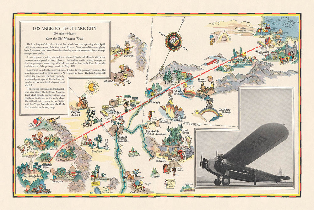
Step into the golden age of aviation with this captivating 1929 pictorial map, "Los Angeles-Salt Lake City," masterfully illustrated by Ruth Taylor White. Commissioned by Western Air Express, this map was created at a pivotal moment in American history, when commercial air travel was just beginning to reshape the nation’s sense of distance and adventure. White’s artistry captures not only the technical marvel of a 600-mile flight across the American West, but also the spirit of optimism and innovation that defined the era. The route itself, stretching from the bustling metropolis of Los Angeles to the cultural heart of Salt Lake City, is rendered with a keen eye for both geographic accuracy and visual storytelling.
What sets this map apart is its rich thematic content and engaging pictorial style. Rather than a simple navigation tool, it is a vibrant celebration of the landscapes, cities, and recreational opportunities that awaited the modern traveler. White’s illustrations bring to life the dramatic mountain ranges, lush forests, and sparkling rivers that define the region. Pictorial vignettes of skiers, swimmers, and horseback riders dot the landscape, highlighting the array of leisure activities accessible along the route. This is not just a map—it is an invitation to explore, dream, and experience the West as it was seen from the cockpit of a tri-motored Fokker aircraft.
Historically, this map stands as a testament to the rapid transformation of travel and tourism in the late 1920s. Western Air Express, whose bold arrowhead logo and “Travel by air” tagline are proudly displayed, was at the forefront of making air travel accessible and appealing to the public. The map’s inclusion of flying times, distances, and key waypoints—such as Las Vegas, Cedar City, and the awe-inspiring Great Salt Lake—underscores the era’s fascination with speed, efficiency, and modernity. It offers a rare glimpse into the early days of commercial aviation, when every flight was an adventure and every destination a new frontier.
The artistic merit of Ruth Taylor White’s work is evident in every detail. Her use of color, relief shading, and playful illustrations transforms the map into a lively tableau, where the natural wonders of the Sierra Nevada, Mojave Desert, and Utah’s national parks are as much a part of the journey as the cities themselves. Each place—be it the bustling streets of Los Angeles, the serene expanse of Bryce Canyon, or the historic charm of St. George—is depicted with affection and flair. The map’s double-page format allows for a sweeping, panoramic view that immerses the viewer in the grandeur of the western landscape.
Collectors and history enthusiasts alike will appreciate the map’s dual role as both a practical guide and a piece of cultural history. It encapsulates a moment when air travel was new, glamorous, and transformative, forever changing the way Americans experienced their country. With its combination of historical significance, artistic brilliance, and evocative storytelling, this map is not merely a relic of the past—it is a celebration of an era when the sky was truly the limit.
Places on this map
- Los Angeles, California
- Salt Lake City, Utah
- Las Vegas, Nevada
- San Bernardino, California
- Barstow, California
- Caliente, Nevada
- Cedar City, Utah
- Great Salt Lake, Utah
- Mojave Desert, California/Nevada
- Sierra Nevada Mountains
- Colorado River
- San Gabriel Mountains
- San Fernando Valley, California
- Victorville, California
- St. George, Utah
- Parowan, Utah
- Panguitch, Utah
- Kanab, Utah
- Zion National Park, Utah
- Bryce Canyon, Utah
Notable Features & Landmarks
- The air route from Los Angeles to Salt Lake City, clearly marked
- Illustration of a tri-motored Fokker aircraft flying above the landscape
- The Western Air Express logo (arrowhead) and the tagline “Travel by air”
- Pictorial representations of mountain ranges along the route
- Rivers and lakes illustrated along the flight path
- Recreational activities depicted, including skiing, swimming, and horseback riding
- Forested areas and national parks shown pictorially
- Smaller towns and waypoints labeled along the route
- Visual emphasis on the dramatic terrain, especially mountain passes
- Cartoon-like figures engaging in leisure and sports
- Distances and estimated flying times between key points
- Decorative border with thematic illustrations
- Key landmarks and natural features, such as the Sierra Nevada and Great Salt Lake, illustrated
- Visual cues for both summer and winter tourist attractions
- The map’s orientation is landscape, spanning two pages
- Use of bright, engaging colors typical of Ruth Taylor White’s style
- Relief shading to indicate elevation and mountainous areas
- Air route shown as a bold line or arrow across the map
- Major rivers, such as the Colorado River, depicted
- The map includes both urban and rural features, emphasizing the diversity of the landscape
Historical and design context
- Created in 1929 by Ruth Taylor White, a renowned American illustrator and cartographer
- Commissioned by Western Air Express to promote early commercial air travel
- Reflects the emerging aviation culture and the expansion of commercial air routes in the late 1920s
- Serves as both a promotional tool and a piece of visual culture from the era
- Provides a snapshot of early commercial aviation and its impact on regional connectivity and tourism
- The map’s vibrant, hand-drawn pictorial style brings to life both geographic accuracy and artistic flair
- Highlights the novelty and excitement of air travel as a modern, efficient alternative to rail or automobile travel
- Includes practical details such as flying times and distances, appealing to tourists and early air travelers
- Part of a larger publication that included tourist information and indexes for multiple Western U.S. air routes
- Offers a rare glimpse into the early days of American air travel, when every flight was an adventure
Please double check the images to make sure that a specific town or place is shown on this map. You can also get in touch and ask us to check the map for you.
This map looks great at every size, but I always recommend going for a larger size if you have space. That way you can easily make out all of the details.
This map looks amazing at sizes all the way up to 70in (180cm). If you are looking for a larger map, please get in touch.
The model in the listing images is holding the 24x36in (60x90cm) version of this map.
The fifth listing image shows an example of my map personalisation service.
If you’re looking for something slightly different, check out my collection of the best old maps to see if something else catches your eye.
Please contact me to check if a certain location, landmark or feature is shown on this map.
This would make a wonderful birthday, Christmas, Father's Day, work leaving, anniversary or housewarming gift for someone from the areas covered by this map.
This map is available as a giclée print on acid free archival matte paper, or you can buy it framed. The frame is a nice, simple black frame that suits most aesthetics. Please get in touch if you'd like a different frame colour or material. My frames are glazed with super-clear museum-grade acrylic (perspex/acrylite), which is significantly less reflective than glass, safer, and will always arrive in perfect condition.
This map is also available as a float framed canvas, sometimes known as a shadow gap framed canvas or canvas floater. The map is printed on artist's cotton canvas and then stretched over a handmade box frame. We then "float" the canvas inside a wooden frame, which is available in a range of colours (black, dark brown, oak, antique gold and white). This is a wonderful way to present a map without glazing in front. See some examples of float framed canvas maps and explore the differences between my different finishes.
For something truly unique, this map is also available in "Unique 3D", our trademarked process that dramatically transforms the map so that it has a wonderful sense of depth. We combine the original map with detailed topography and elevation data, so that mountains and the terrain really "pop". For more info and examples of 3D maps, check my Unique 3D page.
Para la mayoría de los pedidos, el tiempo de entrega es de aproximadamente 3 días laborables. Los productos personalizados y a medida tardan más, ya que tengo que hacer la personalización y enviártelo para su aprobación, lo cual suele tardar 1 o 2 días.
Tenga en cuenta que los pedidos enmarcados muy grandes suelen tardar más en fabricarse y entregarse.
Si necesitas que tu pedido llegue para una fecha determinada, por favor contáctame antes de hacer el pedido para que podamos encontrar la mejor manera de asegurarnos de que recibas tu pedido a tiempo.
Imprimo y enmarco mapas y obras de arte en 23 países alrededor del mundo. Esto significa que tu pedido se fabricará localmente, lo que reduce el tiempo de entrega y asegura que no se dañe durante el envío. Nunca pagarás aranceles de aduana o impuestos de importación, y pondremos menos CO2 en el aire.
Todos mis mapas y impresiones artísticas están bien empaquetados y enviados en un tubo resistente si no están enmarcados, o rodeados de espuma si están enmarcados.
Intento enviar todos los pedidos dentro de 1 o 2 días después de recibir tu pedido, aunque algunos productos (como mascarillas, tazas y bolsas de tela) pueden tardar más en fabricarse.
Si seleccionas Entrega Exprés al finalizar la compra, priorizaremos tu pedido y lo enviaremos por mensajería de 1 día (Fedex, DHL, UPS, Parcelforce).
La entrega al día siguiente también está disponible en algunos países (EE. UU., Reino Unido, Singapur, EAU), pero por favor intenta hacer tu pedido temprano en el día para que podamos enviarlo a tiempo.
Mi marco estándar es un marco de madera de fresno negro estilo galería. Es simple y tiene un aspecto bastante moderno. Mi marco estándar tiene alrededor de 20 mm (0.8 in) de ancho.
Utilizo acrílico super claro (perspex/acrylite) para el vidrio del marco. Es más ligero y seguro que el vidrio, y se ve mejor, ya que la reflectividad es menor.
Seis colores de marco estándar están disponibles de forma gratuita (negro, marrón oscuro, gris oscuro, roble, blanco y oro antiguo).El enmarcado y montaje/matizado personalizado está disponible si buscas algo diferente.
La mayoría de los mapas, arte e ilustraciones también están disponibles como un lienzo enmarcado. Utilizamos lienzo de algodón mate (no brillante), lo estiramos sobre un marco de madera de caja de origen sostenible, y luego 'flotamos' la pieza dentro de un marco de madera. El resultado final es bastante hermoso, y no hay cristal que se interponga.
Todos los marcos se proporcionan "listos para colgar", con una cuerda o soportes en la parte posterior. Los marcos muy grandes tendrán placas de colgar de alta resistencia y/o un listón de montaje. Si tienes alguna pregunta, por favor ponte en contacto.
Mira algunos ejemplos de mis mapas enmarcados y mapas en lienzo enmarcados.
Alternativamente, también puedo proporcionar mapas antiguos y obras de arte en lienzo, tablero de espuma, papel de algodón y otros materiales.
Si deseas enmarcar tu mapa o obra de arte tú mismo, por favor lee mi guía de tamaños primero.
Algunos de mis mapas antiguos ahora están disponibles como lienzos enmarcados. Por favor contáctame si deseas pedir un tamaño que no está disponible en mi tienda.
Los mapas antiguos en lienzo son una alternativa interesante a los mapas enmarcados convencionalmente. Dependiendo de tu gusto personal y la decoración de la habitación, los mapas en lienzo pueden "destacar" un poco más que un mapa enmarcado.
Mis mapas son reproducciones de mapas originales de altísima calidad.
Obtengo mapas originales y raros de bibliotecas, casas de subastas y colecciones privadas de todo el mundo, los restauro en mi taller de Londres y luego uso tintas e impresoras giclée especializadas para crear hermosos mapas que lucen incluso mejor que el original.
Mis mapas están impresos en papel de archivo mate (no brillante) sin ácido que se siente de muy alta calidad y casi como una tarjeta. En términos técnicos, el peso/grosor del papel es de 10 mil/200 g/m². Es perfecto para enmarcar.
Imprimo con tintas pigmentadas Epson ultrachrome giclée UV resistentes a la decoloración, algunas de las mejores tintas que puedes encontrar.
yo también puedo hacer mapas sobre lienzo, trapo de algodón y otros materiales exóticos.
Obtenga más información sobre The Unique Maps Co..
Personalización de mapas
Si está buscando el regalo perfecto de aniversario o inauguración de la casa, puedo personalizar su mapa para hacerlo verdaderamente único. Por ejemplo, puedo agregar un mensaje corto, resaltar una ubicación importante o agregar el escudo de armas de su familia.
Las opciones son casi infinitas. Por favor mira mi página de personalización de mapas para ver algunos maravillosos ejemplos de lo que es posible.
Para pedir un mapa personalizado, seleccione "personalizar su mapa" antes de agregarlo a su carrito.
Ponerse en contacto si buscas personalizaciones y personalizaciones más complejas.
Envejecimiento del mapa
A lo largo de los años, los clientes me han preguntado cientos de veces si podían comprar un mapa que se viera uniforme. más viejo.
Bueno, ahora puedes hacerlo seleccionando Envejecido antes de agregar un mapa a tu carrito.
Todas las fotografías de productos que ve en esta página muestran el mapa en su forma original. Así es como se ve el mapa hoy.
Si selecciona Envejecido, envejeceré su mapa a mano, usando un proceso especial y único desarrollado a través de años de estudiar mapas antiguos, hablar con investigadores para comprender la química del envejecimiento del papel y, por supuesto... ¡mucha práctica!
Si no estás seguro, quédate con el color original del mapa. Si quieres algo un poco más oscuro y más viejo buscando, opte por Envejecido.
Si no estás satisfecho con tu pedido por cualquier motivo, contáctame para un reembolso sin complicaciones. Por favor, consulta nuestra política de devoluciones y reembolsos para más información.
Estoy muy seguro de que te gustará tu mapa o impresión artística restaurada. He estado haciendo esto desde 1984. Soy un vendedor de 5 estrellas en Etsy. He vendido decenas de miles de mapas e impresiones artísticas y tengo más de 5,000 opiniones reales de 5 estrellas.
Utilizo un proceso único para restaurar mapas y obras de arte que consume mucho tiempo y mano de obra. Buscar los mapas e ilustraciones originales puede llevar meses. Utilizo tecnología de última generación y extremadamente cara para escanear y restaurarlos. Como resultado, garantizo que mis mapas e impresiones artísticas son superiores a los demás - por eso puedo ofrecer un reembolso sin complicaciones.
Casi todos mis mapas e impresiones artísticas se ven increíbles en tamaños grandes (200cm, 6.5ft+) y también puedo enmarcarlos y entregártelos a través de un servicio de mensajería especial para tamaños grandes. Contáctame para discutir tus necesidades específicas.
Or try searching for something!


