


Old Pictorial Map of the Pacific Economy by Covarrubias, 1940: Trade, Resources, Pre-WWII Art
- All taxes and duties included
- Handmade & dispatched in 1-2 days
-
90 day money back guarantee
ⓘ
90 días para devolver y reembolsar
Los productos se pueden devolver dentro de los 90 días para un reembolso completo, o cambio por otro producto.
Para artículos personalizados o hechos a medida, podemos ofrecerte un crédito en la tienda o una tarjeta de regalo que no caduca, ya que no podemos revender pedidos personalizados.
Si tienes alguna pregunta, ponte en contacto. Para más información, consulta nuestra política de devoluciones y cambios.

My maps are rare, museum-grade, restored old maps sourced from libraries, auction houses and private collections across the globe.
Framing & free personalisation available
1. Select your size
2. Frame & personalise your map
Make your map unique with framing, hand-drawn customisation, vintage ageing, pop art text, unique 3D styling and moreMensaje de regalo y acabado personalizado

Si deseas agregar un mensaje de regalo, o un acabado (rompecabezas, tablero de aluminio, etc.) que no esté disponible aquí, por favor solicítalo en la "nota del pedido" cuando realices la compra.
Cada pedido es hecho a medida, así que si necesitas que el tamaño se ajuste ligeramente, o que se imprima en un material inusual, háznoslo saber. Hemos realizado miles de pedidos personalizados a lo largo de los años, así que hay (casi) nada que no podamos gestionar.
También puedes contactarnos antes de hacer tu pedido, ¡si lo prefieres!

- Handmade locally. No import duty or tax
- FREE Delivery. Arrives in 2-3 days
- Love it or your money back
- Questions? WhatsApp me any time
Own a piece of history
5,000+ 5 star reviews


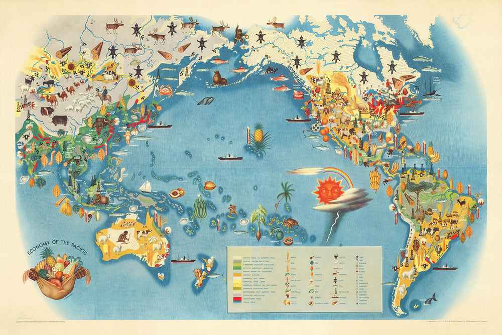
Step into the vibrant world of pre-war Pacific commerce with "Economy of the Pacific," the original 1940 masterpiece by Miguel Covarrubias. This extraordinary pictorial map, conceived for the celebrated Pageant of the Pacific series, was commissioned for the 1939 Golden Gate International Exposition in San Francisco. Covarrubias, often hailed as "Mexico's Renaissance Man," brings together his talents as a painter, illustrator, and anthropologist to create a map that is as intellectually rich as it is visually captivating. The map's title alone evokes a sweeping vision of global trade, industry, and resourcefulness, encapsulating the dynamism of the Pacific Rim on the eve of monumental historical change.
Covarrubias’s "Economy of the Pacific" is more than a geographic document—it is a thematic tapestry that weaves together the economic lifeblood of an entire region. The map vividly illustrates the principal industries and resources that defined the Pacific world in the early twentieth century, from the gold fields of Alaska to the rice paddies of Southeast Asia, and the bustling fisheries of Japan. Through a lively array of pictorial symbols and hand-drawn annotations, viewers are invited to explore the economic interconnections that spanned continents and oceans, shaping the destinies of nations and peoples.
The map’s design is a masterclass in stylized cartography. Covarrubias employs a pictorial approach, eschewing strict political boundaries in favor of richly detailed illustrations that highlight economic activities and natural resources. Ships laden with goods ply the Pacific’s vast expanse, while vignettes of miners, farmers, and fishermen animate the coasts and islands. Decorative borders and corner illustrations add further depth, transforming the map into a work of art that delights the eye while informing the mind. The map’s projection and composition emphasize the Pacific Ocean as a central stage, drawing together the Americas, Asia, Australasia, and the myriad island cultures in between.
Historically, this map stands as a snapshot of a world on the brink of transformation. Created just before the onset of World War II, "Economy of the Pacific" reflects both the optimism and the complexity of the interwar period. It captures the era’s fascination with progress, resource extraction, and global connectivity, while subtly acknowledging the diversity of peoples and cultures that contributed to the Pacific’s economic mosaic. Covarrubias’s anthropological insight infuses the map with a sense of humanity, making it a valuable artifact for historians, collectors, and anyone with an appreciation for the interplay between art and history.
Owning "Economy of the Pacific" is to possess a rare window into the artistic and intellectual ferment of the late 1930s and early 1940s. Whether displayed in a study, library, or gallery, this map offers endless fascination—inviting viewers to trace the routes of ancient traders, imagine the lives of workers and adventurers, and appreciate the enduring legacy of Covarrubias’s vision. It is a testament to the power of maps not only to chart geography, but to tell the stories of civilizations at the crossroads of change.
Countries and regions on this map
- North America (including Canada, United States, Mexico)
- Central America
- South America (notably the Pacific coast)
- East Asia (including China, Japan, Korea)
- Southeast Asia (including the Philippines, Indonesia, Malaysia, Indochina)
- Australia
- New Zealand
- Pacific Islands (including Hawaii, Fiji, Papua New Guinea, Solomon Islands, and others)
- Siberia (Russian Far East)
- Alaska
Notable Features & Landmarks
- Illustrated representations of economic activities such as fishing, whaling, mining, agriculture, forestry, and trade
- Pictorial symbols for resources like oil, minerals, timber, rice, sugar, and fish
- Depictions of ships, boats, and sea routes crisscrossing the Pacific Ocean
- Stylized illustrations of workers, farmers, and indigenous peoples engaged in economic activities
- Large, labeled bodies of water: Pacific Ocean, Bering Sea, Coral Sea, Tasman Sea, Sea of Japan, South China Sea, Philippine Sea, and others
- Major mountain ranges illustrated, such as the Andes and the Rockies
- Decorative borders and corner vignettes showing economic scenes or products
- Shipping lanes and trade routes indicated
- Annotations and labels highlighting key products or industries in various regions (e.g., "wheat," "cotton," "gold," "rubber," "pearls")
- Artistic renderings of islands, archipelagos, and coastal features
Historical and design context
- Created by Miguel Covarrubias, a renowned Mexican painter, illustrator, filmmaker, and anthropologist, often referred to as "Mexico's Renaissance Man"
- Originally made in 1940 for the 1939 Golden Gate International Exposition in San Francisco
- Part of the "Pageant of the Pacific" series, which included six wall-sized maps
- Thematic and pictorial world map focusing on the economic activities and resources of the Pacific region
- Highly stylized, pictorial, and colorful, using illustrations and symbols to represent economic activities, resources, and industries
- Reflects contemporary understanding of Pacific economies before World War II and showcases Covarrubias's unique artistic and anthropological perspective
- Intended for exhibition and public engagement, blending art and information in a visually engaging manner
Please double check the images to make sure that a specific town or place is shown on this map. You can also get in touch and ask us to check the map for you.
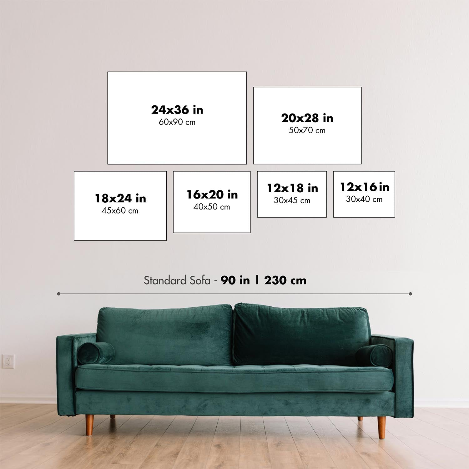
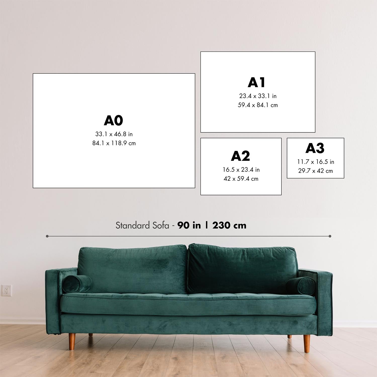
This map looks great at every size, but I always recommend going for a larger size if you have space. That way you can easily make out all of the details.
This map looks amazing at sizes all the way up to 100in (250cm). If you are looking for a larger map, please get in touch.
Please note: the labels on this map are hard to read if you order a map that is 20in (50cm) or smaller. The map is still very attractive, but if you would like to read the map easily, please buy a larger size.
The model in the listing images is holding the 24x36in (60x90cm) version of this map.
The fifth listing image shows an example of my map personalisation service.
If you’re looking for something slightly different, check out my collection of the best old maps to see if something else catches your eye.
Please contact me to check if a certain location, landmark or feature is shown on this map.
This would make a wonderful birthday, Christmas, Father's Day, work leaving, anniversary or housewarming gift for someone from the areas covered by this map.
This map is available as a giclée print on acid free archival matte paper, or you can buy it framed. The frame is a nice, simple black frame that suits most aesthetics. Please get in touch if you'd like a different frame colour or material. My frames are glazed with super-clear museum-grade acrylic (perspex/acrylite), which is significantly less reflective than glass, safer, and will always arrive in perfect condition.
This map is also available as a float framed canvas, sometimes known as a shadow gap framed canvas or canvas floater. The map is printed on artist's cotton canvas and then stretched over a handmade box frame. We then "float" the canvas inside a wooden frame, which is available in a range of colours (black, dark brown, oak, antique gold and white). This is a wonderful way to present a map without glazing in front. See some examples of float framed canvas maps and explore the differences between my different finishes.
For something truly unique, this map is also available in "Unique 3D", our trademarked process that dramatically transforms the map so that it has a wonderful sense of depth. We combine the original map with detailed topography and elevation data, so that mountains and the terrain really "pop". For more info and examples of 3D maps, check my Unique 3D page.
Para la mayoría de los pedidos, el tiempo de entrega es de aproximadamente 3 días laborables. Los productos personalizados y a medida tardan más, ya que tengo que hacer la personalización y enviártelo para su aprobación, lo cual suele tardar 1 o 2 días.
Tenga en cuenta que los pedidos enmarcados muy grandes suelen tardar más en fabricarse y entregarse.
Si necesitas que tu pedido llegue para una fecha determinada, por favor contáctame antes de hacer el pedido para que podamos encontrar la mejor manera de asegurarnos de que recibas tu pedido a tiempo.
Imprimo y enmarco mapas y obras de arte en 23 países alrededor del mundo. Esto significa que tu pedido se fabricará localmente, lo que reduce el tiempo de entrega y asegura que no se dañe durante el envío. Nunca pagarás aranceles de aduana o impuestos de importación, y pondremos menos CO2 en el aire.
Todos mis mapas y impresiones artísticas están bien empaquetados y enviados en un tubo resistente si no están enmarcados, o rodeados de espuma si están enmarcados.
Intento enviar todos los pedidos dentro de 1 o 2 días después de recibir tu pedido, aunque algunos productos (como mascarillas, tazas y bolsas de tela) pueden tardar más en fabricarse.
Si seleccionas Entrega Exprés al finalizar la compra, priorizaremos tu pedido y lo enviaremos por mensajería de 1 día (Fedex, DHL, UPS, Parcelforce).
La entrega al día siguiente también está disponible en algunos países (EE. UU., Reino Unido, Singapur, EAU), pero por favor intenta hacer tu pedido temprano en el día para que podamos enviarlo a tiempo.
Mi marco estándar es un marco de madera de fresno negro estilo galería. Es simple y tiene un aspecto bastante moderno. Mi marco estándar tiene alrededor de 20 mm (0.8 in) de ancho.
Utilizo acrílico super claro (perspex/acrylite) para el vidrio del marco. Es más ligero y seguro que el vidrio, y se ve mejor, ya que la reflectividad es menor.
Seis colores de marco estándar están disponibles de forma gratuita (negro, marrón oscuro, gris oscuro, roble, blanco y oro antiguo).El enmarcado y montaje/matizado personalizado está disponible si buscas algo diferente.
La mayoría de los mapas, arte e ilustraciones también están disponibles como un lienzo enmarcado. Utilizamos lienzo de algodón mate (no brillante), lo estiramos sobre un marco de madera de caja de origen sostenible, y luego 'flotamos' la pieza dentro de un marco de madera. El resultado final es bastante hermoso, y no hay cristal que se interponga.
Todos los marcos se proporcionan "listos para colgar", con una cuerda o soportes en la parte posterior. Los marcos muy grandes tendrán placas de colgar de alta resistencia y/o un listón de montaje. Si tienes alguna pregunta, por favor ponte en contacto.
Mira algunos ejemplos de mis mapas enmarcados y mapas en lienzo enmarcados.
Alternativamente, también puedo proporcionar mapas antiguos y obras de arte en lienzo, tablero de espuma, papel de algodón y otros materiales.
Si deseas enmarcar tu mapa o obra de arte tú mismo, por favor lee mi guía de tamaños primero.
Algunos de mis mapas antiguos ahora están disponibles como lienzos enmarcados. Por favor contáctame si deseas pedir un tamaño que no está disponible en mi tienda.
Los mapas antiguos en lienzo son una alternativa interesante a los mapas enmarcados convencionalmente. Dependiendo de tu gusto personal y la decoración de la habitación, los mapas en lienzo pueden "destacar" un poco más que un mapa enmarcado.
Mis mapas son reproducciones de mapas originales de altísima calidad.
Obtengo mapas originales y raros de bibliotecas, casas de subastas y colecciones privadas de todo el mundo, los restauro en mi taller de Londres y luego uso tintas e impresoras giclée especializadas para crear hermosos mapas que lucen incluso mejor que el original.
Mis mapas están impresos en papel de archivo mate (no brillante) sin ácido que se siente de muy alta calidad y casi como una tarjeta. En términos técnicos, el peso/grosor del papel es de 10 mil/200 g/m². Es perfecto para enmarcar.
Imprimo con tintas pigmentadas Epson ultrachrome giclée UV resistentes a la decoloración, algunas de las mejores tintas que puedes encontrar.
yo también puedo hacer mapas sobre lienzo, trapo de algodón y otros materiales exóticos.
Obtenga más información sobre The Unique Maps Co..
Personalización de mapas
Si está buscando el regalo perfecto de aniversario o inauguración de la casa, puedo personalizar su mapa para hacerlo verdaderamente único. Por ejemplo, puedo agregar un mensaje corto, resaltar una ubicación importante o agregar el escudo de armas de su familia.
Las opciones son casi infinitas. Por favor mira mi página de personalización de mapas para ver algunos maravillosos ejemplos de lo que es posible.
Para pedir un mapa personalizado, seleccione "personalizar su mapa" antes de agregarlo a su carrito.
Ponerse en contacto si buscas personalizaciones y personalizaciones más complejas.
Envejecimiento del mapa
A lo largo de los años, los clientes me han preguntado cientos de veces si podían comprar un mapa que se viera uniforme. más viejo.
Bueno, ahora puedes hacerlo seleccionando Envejecido antes de agregar un mapa a tu carrito.
Todas las fotografías de productos que ve en esta página muestran el mapa en su forma original. Así es como se ve el mapa hoy.
Si selecciona Envejecido, envejeceré su mapa a mano, usando un proceso especial y único desarrollado a través de años de estudiar mapas antiguos, hablar con investigadores para comprender la química del envejecimiento del papel y, por supuesto... ¡mucha práctica!
Si no estás seguro, quédate con el color original del mapa. Si quieres algo un poco más oscuro y más viejo buscando, opte por Envejecido.
Si no estás satisfecho con tu pedido por cualquier motivo, contáctame para un reembolso sin complicaciones. Por favor, consulta nuestra política de devoluciones y reembolsos para más información.
Estoy muy seguro de que te gustará tu mapa o impresión artística restaurada. He estado haciendo esto desde 1984. Soy un vendedor de 5 estrellas en Etsy. He vendido decenas de miles de mapas e impresiones artísticas y tengo más de 5,000 opiniones reales de 5 estrellas.
Utilizo un proceso único para restaurar mapas y obras de arte que consume mucho tiempo y mano de obra. Buscar los mapas e ilustraciones originales puede llevar meses. Utilizo tecnología de última generación y extremadamente cara para escanear y restaurarlos. Como resultado, garantizo que mis mapas e impresiones artísticas son superiores a los demás - por eso puedo ofrecer un reembolso sin complicaciones.
Casi todos mis mapas e impresiones artísticas se ven increíbles en tamaños grandes (200cm, 6.5ft+) y también puedo enmarcarlos y entregártelos a través de un servicio de mensajería especial para tamaños grandes. Contáctame para discutir tus necesidades específicas.
Or try searching for something!


