

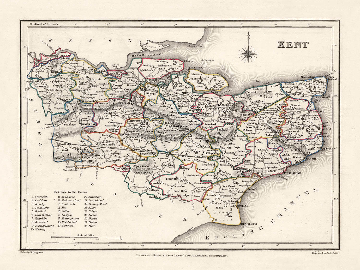
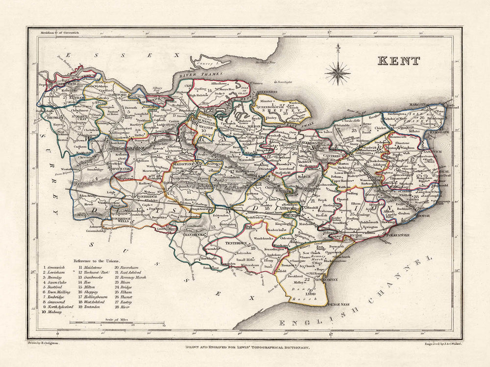


Mapa antiguo de Kent por Samuel Lewis, 1844: Maidstone, Gillingham, Ashford, Royal Tunbridge Wells y Margate
20% de descuento en 2 — 33% de descuento en 3
Añade dos artículos elegibles a tu carrito para recibir 20% de descuento. Añade un tercero y será complementario (equivalente a 33% de descuento al comprar tres).
No se necesita código — la oferta se aplica automáticamente al finalizar la compra.
Válido en todos los mapas estándar y impresiones de arte fino. Puedes mezclar y combinar cualquier diseño.
Si deseas enviar artículos a múltiples direcciones, por favor contáctanos antes de realizar tu pedido.
Las comisiones personalizadas y a medida están excluidas.
Contáctanos si tienes alguna pregunta
- All taxes and duties included
- Handmade & dispatched in 1-2 days
-
Complimentary gifting & design advice
ⓘ
Complimentary gifting & design advice
Available almost 24/7 on WhatsApp and email — we usually reply within minutes. We can help you:
- Choose a perfectly personalised gift
- Send a digital gift preview to the recipient
- Pick the ideal size for your wall
- Select the right finish and frame
Quick, friendly advice so you can order with confidence.
For last minute gifts, consider buying a digital gift card. We have over 5,000 maps and art prints to choose from.
-
90-day returns & 5-year guarantee
ⓘ
90 días para devolver y reembolsar
Los productos se pueden devolver dentro de los 90 días para un reembolso completo, o cambio por otro producto.
Para artículos personalizados y hechos a medida, podemos ofrecerte crédito en la tienda o una tarjeta de regalo sin fecha de caducidad, ya que no podemos revender pedidos personalizados.
Si tienes alguna pregunta, ponte en contacto. Para más información, consulta nuestra política de devoluciones y cambios.

This is a museum-grade archival print from the original 1844 map — restored in our workshop and made to order on 220gsm archival matte paper or 400gsm artist's cotton canvas with pigment inks.
Beautifully framed and ready to hang, with complimentary personalisation available.
1. Choose a size
2. Frame & personalise your map
Make your map unique with framing, hand-drawn customisation, vintage ageing, pop art text, unique 3D styling and more.


Mensaje de regalo y acabado personalizado

Si deseas agregar un mensaje de regalo, o un acabado (rompecabezas, tablero de aluminio, etc.) que no esté disponible aquí, por favor solicítalo en la "nota del pedido" cuando realices la compra.
Cada pedido es hecho a medida, así que si necesitas que el tamaño se ajuste ligeramente, o que se imprima en un material inusual, háznoslo saber. Hemos realizado miles de pedidos personalizados a lo largo de los años, así que hay (casi) nada que no podamos gestionar.
También puedes contactarnos antes de hacer tu pedido, ¡si lo prefieres!

- Handmade locally. No import duty or tax
- FREE worldwide delivery
- 90-day returns & 5-year product guarantee
- Questions? WhatsApp me any time
Own a piece of history
7,000+ 5 star reviews


Descubre la grandeza histórica de Kent a través del meticulosamente elaborado mapa de 1844 de Samuel Lewis, un tesoro para admirar tanto para los entusiastas de la historia como para los conocedores de la cartografía. Esta representación anticuada de uno de los condados más antiguos e influyentes de Inglaterra captura la esencia del pasado, mostrando asentamientos que preceden a 1840, incluyendo muchas de las bulliciosas ciudades de hoy. Como tal, pinta un fascinante retrato de una época en la que algunas de las ciudades y pueblos más prominentes de hoy estaban apenas formándose o, emocionantemente, eran conocidos por diferentes nombres.
Una de las características más significativas de este mapa es su capacidad para transportarte de regreso en el tiempo a un Kent que es tan familiar como extraño. Cada detalle ha sido preservado, desde la delicada caligrafía que denota los nombres de las ciudades, hasta el arte del esbozo de los límites del condado y las características naturales. Este mapa de 1844 encapsula un período de transición y desarrollo crítico dentro de Kent y sirve como una conexión tangible con el pasado, recordándonos la base perdurable sobre la cual se construye el presente.
Asentamientos Destacados:
- Maidstone (Fundada alrededor del año 975 d.C.): La actual ciudad capital de Kent, Maidstone cuenta con una rica historia reflejada en su impresionante arquitectura, incluyendo el Museo de Maidstone y el Castillo de Leeds.
- Gillingham (Fundada en el siglo XIII): El Museo de Ingenieros Reales en Gillingham documenta la historia de la ingeniería militar de la ciudad.
- Ashford (Fundada alrededor del año 500 d.C.): Famosa por el Ashford Designer Outlet, la ciudad también ocupa una posición importante en la historia ferroviaria de Kent.
- Royal Tunbridge Wells (Fundada en el siglo XVII): Conocida por el manantial Chalybeate, se convirtió en una popular ciudad balneario en la Era Georgiana.
- Margate (Fundada en el siglo XIII): Conocida por sus playas de arena, Margate fue uno de los primeros balnearios ingleses.
- Dover (Fundada alrededor del siglo I a.C.): Conocida por los Acantilados Blancos de Dover y el Castillo de Dover, uno de los castillos más grandes de Inglaterra.
- Canterbury (Fundada en el siglo I d.C.): Canterbury, con su catedral, es uno de los sitios de peregrinación cristiana más famosos del mundo.
- Folkestone (Fundada en el siglo VII): Conocida por el Lower Leas Coastal Park y el Folkestone Harbour Arm.
- Sittingbourne (Fundada en la Edad Media): Una ciudad industrial famosa por la fabricación de ladrillos y producción de papel.
- Gravesend (Fundada en el siglo X): Conocida por la estatua de Pocahontas en la Iglesia de San Jorge, donde fue enterrada en 1617.
- Herne Bay (Fundada a principios del siglo XIX): Conocida por su arquitectura victoriana y su hermosa bahía.
- Faversham (Fundada en el siglo I d.C.): Conocida por la cervecería más antigua del país, Shepherd Neame.
- Whitstable (Fundada antes del siglo X): Famosa por sus ostras, celebradas en el festival anual de ostras de Whitstable.
- Tonbridge (Fundada en el siglo XI): El Castillo de Tonbridge es un hito notable en esta ciudad.
- Sevenoaks (Fundada en el siglo XIII): Nombrada por siete robles en Knole Park, alberga la propiedad de National Trust, Knole House.
- Dartford (Fundada en la era romana): Conocida por su asociación con la industria de fabricación de papel y Mick Jagger de los Rolling Stones.
- Deal (Fundada en el siglo XIII): Conocida por su arquitectura georgiana y el Castillo de Deal, construido por Enrique VIII.
- Ramsgate (Fundada a principios del siglo XIX): Conocida por su marina, playas y el único puerto 'Real' en el Reino Unido.
Fenómenos Naturales y Atracciones Notables:
- Los Acantilados Blancos de Dover: Una característica natural icónica que ha sido un símbolo de Gran Bretaña durante siglos.
- Río Medway: El principal río de Kent, que ha sido una ruta comercial clave y ofrece hermosos paseos.
- Los North Downs: Un área de belleza natural excepcional con una variedad de rutas de senderismo.
- El Weald de Kent: Una región histórica llena de bosques antiguos y paisajes escénicos.
- El Romney Marsh: Conocido por su belleza natural única, es uno de los últimos desiertos en el sur de Inglaterra.
Eventos Históricos (1800-1850):
- La Batalla de Bossenden Wood (1838): Un enfrentamiento a pequeña escala en Kent durante un período de agitación política, es la última batalla en suelo inglés.
- Los Disturbios de Swing (1830): Los trabajadores agrícolas de todo el sur de Inglaterra, incluido Kent, protestaron contra sus condiciones en deterioro.
Por favor, verifica las imágenes para asegurarte de que una ciudad o lugar específico esté mostrado en este mapa. También puedes ponerte en contacto y pedirnos que verifiquemos el mapa por ti.
Este mapa se ve genial en todos los tamaños: 8x10in (20.5x25.5cm), 12x16in (30.5x41cm), 18x24in (45.5x61cm), 16x20in (40.5x51cm), 24x36in (61x91.5cm), 30x40in (76x101.5cm) y 37x50in (94x127cm), pero se ve aún mejor cuando se imprime en grande.
Puedo crear impresiones grandes y hermosas de este mapa de hasta 50in (127cm). Por favor, contáctame si estás buscando opciones de enmarcado más grandes, personalizadas o diferentes.
El modelo en las imágenes de la lista sostiene la versión de este mapa de 18x24in (45.5x61cm).
La quinta imagen de la lista muestra un ejemplo de mi servicio de personalización de mapas.
Si estás buscando algo ligeramente diferente, consulta mi colección principal de mapas del Reino Unido e Irlanda.
Por favor, contáctame para verificar si una ubicación, hito o característica específica está mostrada en este mapa.
Esto sería un regalo maravilloso para un cumpleaños, Navidad, Día del Padre, despedida de trabajo, aniversario o inauguración de casa para alguien de las áreas cubiertas por este mapa.
Este mapa está disponible como una impresión giclée en papel mate archival libre de ácido, o puedes comprarlo enmarcado. El marco es un bonito y simple marco negro que se adapta a la mayoría de las estéticas. Por favor, ponte en contacto si deseas un color o material de marco diferente. Mis marcos están envidriados con acrílico de grado museo superclaro (perspex/acrylite), que es significativamente menos reflectante que el vidrio, más seguro, y siempre llegará en perfectas condiciones.
This map is also available as a float framed canvas, sometimes known as a shadow gap framed canvas or canvas floater. The map is printed on artist's cotton canvas and then stretched over a handmade box frame. We then "float" the canvas inside a wooden frame, which is available in a range of colours (black, dark brown, oak, antique gold and white). This is a wonderful way to present a map without glazing in front. See some examples of float framed canvas maps and explore the differences between my different finishes.
For something truly unique, this map is also available in "Unique 3D", our trademarked process that dramatically transforms the map so that it has a wonderful sense of depth. We combine the original map with detailed topography and elevation data, so that mountains and the terrain really "pop". For more info and examples of 3D maps, check my Unique 3D page.
Para la mayoría de los pedidos, el tiempo de entrega es de aproximadamente 3 días laborables. Los productos personalizados y a medida tardan más, ya que tengo que hacer la personalización y enviártelo para su aprobación, lo cual suele tardar 1 o 2 días.
Tenga en cuenta que los pedidos enmarcados muy grandes suelen tardar más en fabricarse y entregarse.
Si necesitas que tu pedido llegue para una fecha determinada, por favor contáctame antes de hacer el pedido para que podamos encontrar la mejor manera de asegurarnos de que recibas tu pedido a tiempo.
Imprimo y enmarco mapas y obras de arte en 23 países alrededor del mundo. Esto significa que tu pedido se fabricará localmente, lo que reduce el tiempo de entrega y asegura que no se dañe durante el envío. Nunca pagarás aranceles de aduana o impuestos de importación, y pondremos menos CO2 en el aire.
Todos mis mapas y impresiones artísticas están bien empaquetados y enviados en un tubo resistente si no están enmarcados, o rodeados de espuma si están enmarcados.
Intento enviar todos los pedidos dentro de 1 o 2 días después de recibir tu pedido, aunque algunos productos (como mascarillas, tazas y bolsas de tela) pueden tardar más en fabricarse.
Si seleccionas Entrega Exprés al finalizar la compra, priorizaremos tu pedido y lo enviaremos por mensajería de 1 día (Fedex, DHL, UPS, Parcelforce).
La entrega al día siguiente también está disponible en algunos países (EE. UU., Reino Unido, Singapur, EAU), pero por favor intenta hacer tu pedido temprano en el día para que podamos enviarlo a tiempo.
Mi marco estándar es un marco de madera de fresno negro estilo galería. Es simple y tiene un aspecto bastante moderno. Mi marco estándar tiene alrededor de 20 mm (0.8 in) de ancho.
Utilizo acrílico super claro (perspex/acrylite) para el vidrio del marco. Es más ligero y seguro que el vidrio, y se ve mejor, ya que la reflectividad es menor.
Seis colores de marco estándar están disponibles de forma gratuita (negro, marrón oscuro, gris oscuro, roble, blanco y oro antiguo).El enmarcado y montaje/matizado personalizado está disponible si buscas algo diferente.
La mayoría de los mapas, arte e ilustraciones también están disponibles como un lienzo enmarcado. Utilizamos lienzo de algodón mate (no brillante), lo estiramos sobre un marco de madera de caja de origen sostenible, y luego 'flotamos' la pieza dentro de un marco de madera. El resultado final es bastante hermoso, y no hay cristal que se interponga.
Todos los marcos se proporcionan "listos para colgar", con una cuerda o soportes en la parte posterior. Los marcos muy grandes tendrán placas de colgar de alta resistencia y/o un listón de montaje. Si tienes alguna pregunta, por favor ponte en contacto.
Mira algunos ejemplos de mis mapas enmarcados y mapas en lienzo enmarcados.
Alternativamente, también puedo proporcionar mapas antiguos y obras de arte en lienzo, tablero de espuma, papel de algodón y otros materiales.
Si deseas enmarcar tu mapa o obra de arte tú mismo, por favor lee mi guía de tamaños primero.
Algunos de mis mapas antiguos ahora están disponibles como lienzos enmarcados. Por favor contáctame si deseas pedir un tamaño que no está disponible en mi tienda.
Los mapas antiguos en lienzo son una alternativa interesante a los mapas enmarcados convencionalmente. Dependiendo de tu gusto personal y la decoración de la habitación, los mapas en lienzo pueden "destacar" un poco más que un mapa enmarcado.
Mis mapas son reproducciones de mapas originales de altísima calidad.
Obtengo mapas originales y raros de bibliotecas, casas de subastas y colecciones privadas de todo el mundo, los restauro en mi taller de Londres y luego uso tintas e impresoras giclée especializadas para crear hermosos mapas que lucen incluso mejor que el original.
Mis mapas están impresos en papel de archivo mate (no brillante) sin ácido que se siente de muy alta calidad y casi como una tarjeta. En términos técnicos, el peso/grosor del papel es de 10 mil/200 g/m². Es perfecto para enmarcar.
Imprimo con tintas pigmentadas Epson ultrachrome giclée UV resistentes a la decoloración, algunas de las mejores tintas que puedes encontrar.
yo también puedo hacer mapas sobre lienzo, trapo de algodón y otros materiales exóticos.
Obtenga más información sobre The Unique Maps Co..
Personalización de mapas
Si está buscando el regalo perfecto de aniversario o inauguración de la casa, puedo personalizar su mapa para hacerlo verdaderamente único. Por ejemplo, puedo agregar un mensaje corto, resaltar una ubicación importante o agregar el escudo de armas de su familia.
Las opciones son casi infinitas. Por favor mira mi página de personalización de mapas para ver algunos maravillosos ejemplos de lo que es posible.
Para pedir un mapa personalizado, seleccione "personalizar su mapa" antes de agregarlo a su carrito.
Ponerse en contacto si buscas personalizaciones y personalizaciones más complejas.
Envejecimiento del mapa
A lo largo de los años, los clientes me han preguntado cientos de veces si podían comprar un mapa que se viera uniforme. más viejo.
Bueno, ahora puedes hacerlo seleccionando Envejecido antes de agregar un mapa a tu carrito.
Todas las fotografías de productos que ve en esta página muestran el mapa en su forma original. Así es como se ve el mapa hoy.
Si selecciona Envejecido, envejeceré su mapa a mano, usando un proceso especial y único desarrollado a través de años de estudiar mapas antiguos, hablar con investigadores para comprender la química del envejecimiento del papel y, por supuesto... ¡mucha práctica!
Si no estás seguro, quédate con el color original del mapa. Si quieres algo un poco más oscuro y más viejo buscando, opte por Envejecido.
Si no estás satisfecho con tu pedido por cualquier motivo, contáctame para un reembolso sin complicaciones. Por favor, consulta nuestra política de devoluciones y reembolsos para más información.
Estoy muy seguro de que te gustará tu mapa o impresión artística restaurada. He estado haciendo esto desde 1984. Soy un vendedor de 5 estrellas en Etsy. He vendido decenas de miles de mapas e impresiones artísticas y tengo más de 5,000 opiniones reales de 5 estrellas.
Utilizo un proceso único para restaurar mapas y obras de arte que consume mucho tiempo y mano de obra. Buscar los mapas e ilustraciones originales puede llevar meses. Utilizo tecnología de última generación y extremadamente cara para escanear y restaurarlos. Como resultado, garantizo que mis mapas e impresiones artísticas son superiores a los demás - por eso puedo ofrecer un reembolso sin complicaciones.
Casi todos mis mapas e impresiones artísticas se ven increíbles en tamaños grandes (200cm, 6.5ft+) y también puedo enmarcarlos y entregártelos a través de un servicio de mensajería especial para tamaños grandes. Contáctame para discutir tus necesidades específicas.
Or try searching for something!


