

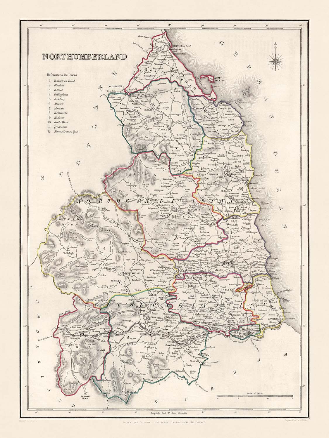


Mapa antiguo de Northumberland por Samuel Lewis, 1844: Newcastle upon Tyne, Blyth, Cramlington, Ashington y Bedlington
Compra 2, Llévate 1 Gratis
Si añades 2 artículos a tu carrito, puedes añadir un tercer producto gratis.
Esto aplica a todos los mapas y obras de arte, incluyendo piezas personalizadas y personalizadas. Puedes pedir 3 de lo mismo, o 3 cosas diferentes.
Esto equivale a un descuento del 33%, que será el mayor descuento disponible en mi tienda este año.
¡Aprovecha la oferta y cubre tus paredes con hermosos mapas y arte!
Contáctame si tienes alguna pregunta.
- All taxes and duties included
- Handmade & dispatched in 1-2 days
-
Complimentary gifting & design advice
ⓘ
Complimentary gifting & design advice
Available almost 24/7 on WhatsApp and email — we usually reply within minutes. We can help you:
- Choose a perfectly personalised gift
- Send a digital gift preview to the recipient
- Pick the ideal size for your wall
- Select the right finish and frame
Quick, friendly advice so you can order with confidence.
For last minute gifts, consider buying a digital gift card. We have over 5,000 maps and art prints to choose from.
-
90-day money back guarantee
ⓘ
90 días para devolver y reembolsar
Los productos se pueden devolver dentro de los 90 días para un reembolso completo, o cambio por otro producto.
Para artículos personalizados y hechos a medida, podemos ofrecerte crédito en la tienda o una tarjeta de regalo sin fecha de caducidad, ya que no podemos revender pedidos personalizados.
Si tienes alguna pregunta, ponte en contacto. Para más información, consulta nuestra política de devoluciones y cambios.

This is a museum-grade archival print from the original 1844 map — restored in our workshop and made to order on 220gsm archival matte paper or 400gsm artist's cotton canvas with pigment inks.
Professional framing & free personalisation available
1. Select your size
Click here to order a custom size.
2. Frame & personalise your map
Make your map unique with framing, hand-drawn customisation, vintage ageing, pop art text, unique 3D styling and more.


Mensaje de regalo y acabado personalizado

Si deseas agregar un mensaje de regalo, o un acabado (rompecabezas, tablero de aluminio, etc.) que no esté disponible aquí, por favor solicítalo en la "nota del pedido" cuando realices la compra.
Cada pedido es hecho a medida, así que si necesitas que el tamaño se ajuste ligeramente, o que se imprima en un material inusual, háznoslo saber. Hemos realizado miles de pedidos personalizados a lo largo de los años, así que hay (casi) nada que no podamos gestionar.
También puedes contactarnos antes de hacer tu pedido, ¡si lo prefieres!

- Handmade locally. No import duty or tax
- FREE worldwide delivery
- Love it or your money back (90 days)
- Questions? WhatsApp me any time
Own a piece of history
5,000+ 5 star reviews


Sumérgete en el pasado con este mapa antiguo de Northumberland, meticulosamente elaborado por Samuel Lewis en 1844. Empapado de historia, esta pieza ofrece una mirada inigualable al condado durante un tiempo de cambio social, económico y geográfico significativo. Encarnando tanto el espíritu de su época como la belleza atemporal de la cartografía, el mapa se erige como un testimonio de la rica historia de Northumberland, una región marcada por asentamientos que datan de la era romana.
Dada su antigüedad, el mapa presenta algunos asentamientos bajo nombres anteriores, añadiendo una capa extra de emoción para el historiador entusiasta. Algunas ciudades modernas pueden no estar presentes, reflejando el paisaje en evolución y el crecimiento dinámico de la región a lo largo del tiempo. Con sus líneas nítidas y detalles intrincados, este mapa de 1844 no es solo una instantánea del pasado—es una obra de arte y un documento histórico combinados.
Asentamientos Notables:
- Newcastle upon Tyne (1080): Establecido como un fuerte y puente por los romanos y más tarde convertido en un importante asentamiento por los normandos, hoy es la ciudad más poblada de Northumberland.
- Blyth (siglo XII): Originándose como un pueblo portuario, Blyth ha evolucionado hasta convertirse en un importante centro comercial conocido por su vibrante puerto.
- Cramlington (1135): Originalmente una pequeña aldea con una economía agrícola, Cramlington es ahora una bulliciosa ciudad conocida por sus industrias.
- Ashington (1847): Conocido por su herencia minera de carbón, Ashington fue referido como "la aldea minera de carbón más grande del mundo."
- Bedlington (principios del siglo XII): Notado por sus fábricas de hierro y la industria de fabricación de clavos en el siglo XIX, fue una ciudad industrial significativa.
- Berwick-upon-Tweed (c. 1018): La ciudad más septentrional de Inglaterra, conocida por su turbulenta historia con alternancia entre el dominio escocés e inglés.
- Hexham (AD 674): Renombrada por la Abadía de Hexham, es una de las fundaciones cristianas más antiguas que sobreviven en Gran Bretaña.
- Prudhoe (1150): Conocido por el Castillo de Prudhoe, un buen ejemplo de una fortificación normanda.
- Morpeth (1199): Una histórica ciudad de mercado, conocida por su mezcla única de patrimonio y belleza.
- Amble (1200s): Una vez un importante puerto marítimo, Amble es ahora una popular ciudad vacacional conocida por su marina y hermosas playas.
- Alnwick (c. 600 d.C.): Famoso por el Castillo de Alnwick, un lugar de filmación para la serie de Harry Potter.
- Ponteland (siglo XIII): Conocido por sus hermosos paisajes rurales y el Castillo de Ponteland.
- Haltwhistle (1200s): Afirmado como el centro geográfico de Gran Bretaña y está cerca de la Muralla de Adriano romana.
- Bellingham (principios del siglo XIII): Puerta de entrada al Parque Nacional de Northumberland, es conocido por su belleza natural.
- Wylam (siglo XII): Lugar de nacimiento de George Stephenson, un ingeniero ferroviario pionero.
- Corbridge (AD 786): Conocido por su sitio arqueológico romano, la Ciudad Romana de Corbridge.
- Allendale Town (1700s): Celebrado por el Allendale Tar Bar'l, una tradición única de Nochevieja.
- Seaton Delaval (siglo XI): Hogar de la arquitectónicamente impresionante Seaton Delaval Hall.
- Alnmouth (1150): Conocido por sus hermosas playas de arena y su vibrante escena portuaria.
- Warkworth (siglo VIII): Una encantadora aldea dominada por el castillo medieval de Warkworth.
- Rothbury (siglo VIII): Conocido por sus hermosos paisajes y como puerta de entrada al Parque Nacional de Northumberland.
- Bamburgh (c. 420): Conocido por el imponente Castillo de Bamburgh y hermosas playas.
- Wooler (1100s): Una pintoresca ciudad de mercado, es la puerta de entrada a las Colinas Cheviot.
- Felton (siglo XII): Hogar de una próspera escena de artes y oficios, ubicado cerca de la impresionante Costa de Northumberland, un Área de Belleza Natural Sobresaliente.
- Otterburn (1086): Conocido por la Batalla de Otterburn que ocurrió en 1388.
- Longhoughton (1100s): Presenta hermosas costas y acceso a algunas de las mejores playas de Northumberland.
- Elsdon (siglo XII): Hogar de un vicaría fortificada medieval preservada y un castillo de motte-and-bailey del siglo XI.
- Bardon Mill (década de 1820): Ubicado cerca de Vindolanda, uno de los sitios arqueológicos romanos más importantes de Europa.
- Heddon-on-the-Wall (principios del siglo XIII): Conocido por su sección del Muro de Adriano.
- Lynemouth (década de 1800): Una vez un pueblo minero de carbón, ahora es conocido por su central eléctrica.
Atracciones Naturales:
- Parque Nacional de Northumberland: Ofrece algunos de los paisajes más prístinos del Reino Unido.
- Cheviot Hills: Colinas onduladas que marcan la frontera entre Inglaterra y Escocia.
- Muro de Adriano: Un Sitio del Patrimonio Mundial de la UNESCO, es uno de los restos más significativos de la época romana en Gran Bretaña.
- Costa de Northumberland AONB: Conocida por su belleza natural sobresaliente, presenta dunas, acantilados y playas de arena.
Eventos Históricos (1800-1850):
- 1804-1806: La construcción del Puente de Cadenas de la Unión, el primer puente colgante vehicular del mundo.
- 1825: La apertura del Ferrocarril de Stanhope y Tyne, mejorando el sistema de transporte de carbón.
- 1838: El establecimiento del Ferrocarril de Newcastle y Carlisle, promoviendo el comercio y los viajes.
- 1844: El año en que se creó este mapa, marcando un período de cambio geográfico y desarrollo significativo en Northumberland.
Por favor, verifica las imágenes para asegurarte de que una ciudad o lugar específico esté mostrado en este mapa. También puedes ponerte en contacto y pedirnos que revisemos el mapa por ti.
Este mapa se ve genial en todos los tamaños: 8x10in (20.5x25.5cm), 12x16in (30.5x41cm), 18x24in (45.5x61cm), 16x20in (40.5x51cm), 24x36in (61x91.5cm), 30x40in (76x101.5cm) y 37x50in (94x127cm), pero se ve aún mejor cuando se imprime en grande.
Puedo crear impresiones grandes y hermosas de este mapa de hasta 50in (127cm). Por favor, contáctame si estás buscando opciones de enmarcado más grandes, personalizadas o diferentes.
El modelo en las imágenes de la lista sostiene la versión de 18x24in (45.5x61cm) de este mapa.
La quinta imagen de la lista muestra un ejemplo de mi servicio de personalización de mapas.
Si estás buscando algo ligeramente diferente, consulta mi colección principal de mapas del Reino Unido e Irlanda.
Por favor, contáctame para verificar si una ubicación, hito o característica específica está mostrada en este mapa.
Este sería un maravilloso regalo de cumpleaños, Navidad, Día del Padre, despedida laboral, aniversario o de inauguración de casa para alguien de las áreas cubiertas por este mapa.
Este mapa está disponible como una impresión giclée en papel mate libre de ácido y de archivo, o puedes comprarlo enmarcado. El marco es un bonito y simple marco negro que se adapta a la mayoría de las estéticas. Por favor, contáctame si deseas un color o material de marco diferente. Mis marcos están envidriados con acrílico de grado museo superclaro (perspex/acrylite), que es significativamente menos reflectante que el vidrio, más seguro y siempre llegará en perfectas condiciones.
This map is also available as a float framed canvas, sometimes known as a shadow gap framed canvas or canvas floater. The map is printed on artist's cotton canvas and then stretched over a handmade box frame. We then "float" the canvas inside a wooden frame, which is available in a range of colours (black, dark brown, oak, antique gold and white). This is a wonderful way to present a map without glazing in front. See some examples of float framed canvas maps and explore the differences between my different finishes.
For something truly unique, this map is also available in "Unique 3D", our trademarked process that dramatically transforms the map so that it has a wonderful sense of depth. We combine the original map with detailed topography and elevation data, so that mountains and the terrain really "pop". For more info and examples of 3D maps, check my Unique 3D page.
Para la mayoría de los pedidos, el tiempo de entrega es de aproximadamente 3 días laborables. Los productos personalizados y a medida tardan más, ya que tengo que hacer la personalización y enviártelo para su aprobación, lo cual suele tardar 1 o 2 días.
Tenga en cuenta que los pedidos enmarcados muy grandes suelen tardar más en fabricarse y entregarse.
Si necesitas que tu pedido llegue para una fecha determinada, por favor contáctame antes de hacer el pedido para que podamos encontrar la mejor manera de asegurarnos de que recibas tu pedido a tiempo.
Imprimo y enmarco mapas y obras de arte en 23 países alrededor del mundo. Esto significa que tu pedido se fabricará localmente, lo que reduce el tiempo de entrega y asegura que no se dañe durante el envío. Nunca pagarás aranceles de aduana o impuestos de importación, y pondremos menos CO2 en el aire.
Todos mis mapas y impresiones artísticas están bien empaquetados y enviados en un tubo resistente si no están enmarcados, o rodeados de espuma si están enmarcados.
Intento enviar todos los pedidos dentro de 1 o 2 días después de recibir tu pedido, aunque algunos productos (como mascarillas, tazas y bolsas de tela) pueden tardar más en fabricarse.
Si seleccionas Entrega Exprés al finalizar la compra, priorizaremos tu pedido y lo enviaremos por mensajería de 1 día (Fedex, DHL, UPS, Parcelforce).
La entrega al día siguiente también está disponible en algunos países (EE. UU., Reino Unido, Singapur, EAU), pero por favor intenta hacer tu pedido temprano en el día para que podamos enviarlo a tiempo.
Mi marco estándar es un marco de madera de fresno negro estilo galería. Es simple y tiene un aspecto bastante moderno. Mi marco estándar tiene alrededor de 20 mm (0.8 in) de ancho.
Utilizo acrílico super claro (perspex/acrylite) para el vidrio del marco. Es más ligero y seguro que el vidrio, y se ve mejor, ya que la reflectividad es menor.
Seis colores de marco estándar están disponibles de forma gratuita (negro, marrón oscuro, gris oscuro, roble, blanco y oro antiguo).El enmarcado y montaje/matizado personalizado está disponible si buscas algo diferente.
La mayoría de los mapas, arte e ilustraciones también están disponibles como un lienzo enmarcado. Utilizamos lienzo de algodón mate (no brillante), lo estiramos sobre un marco de madera de caja de origen sostenible, y luego 'flotamos' la pieza dentro de un marco de madera. El resultado final es bastante hermoso, y no hay cristal que se interponga.
Todos los marcos se proporcionan "listos para colgar", con una cuerda o soportes en la parte posterior. Los marcos muy grandes tendrán placas de colgar de alta resistencia y/o un listón de montaje. Si tienes alguna pregunta, por favor ponte en contacto.
Mira algunos ejemplos de mis mapas enmarcados y mapas en lienzo enmarcados.
Alternativamente, también puedo proporcionar mapas antiguos y obras de arte en lienzo, tablero de espuma, papel de algodón y otros materiales.
Si deseas enmarcar tu mapa o obra de arte tú mismo, por favor lee mi guía de tamaños primero.
Algunos de mis mapas antiguos ahora están disponibles como lienzos enmarcados. Por favor contáctame si deseas pedir un tamaño que no está disponible en mi tienda.
Los mapas antiguos en lienzo son una alternativa interesante a los mapas enmarcados convencionalmente. Dependiendo de tu gusto personal y la decoración de la habitación, los mapas en lienzo pueden "destacar" un poco más que un mapa enmarcado.
Mis mapas son reproducciones de mapas originales de altísima calidad.
Obtengo mapas originales y raros de bibliotecas, casas de subastas y colecciones privadas de todo el mundo, los restauro en mi taller de Londres y luego uso tintas e impresoras giclée especializadas para crear hermosos mapas que lucen incluso mejor que el original.
Mis mapas están impresos en papel de archivo mate (no brillante) sin ácido que se siente de muy alta calidad y casi como una tarjeta. En términos técnicos, el peso/grosor del papel es de 10 mil/200 g/m². Es perfecto para enmarcar.
Imprimo con tintas pigmentadas Epson ultrachrome giclée UV resistentes a la decoloración, algunas de las mejores tintas que puedes encontrar.
yo también puedo hacer mapas sobre lienzo, trapo de algodón y otros materiales exóticos.
Obtenga más información sobre The Unique Maps Co..
Personalización de mapas
Si está buscando el regalo perfecto de aniversario o inauguración de la casa, puedo personalizar su mapa para hacerlo verdaderamente único. Por ejemplo, puedo agregar un mensaje corto, resaltar una ubicación importante o agregar el escudo de armas de su familia.
Las opciones son casi infinitas. Por favor mira mi página de personalización de mapas para ver algunos maravillosos ejemplos de lo que es posible.
Para pedir un mapa personalizado, seleccione "personalizar su mapa" antes de agregarlo a su carrito.
Ponerse en contacto si buscas personalizaciones y personalizaciones más complejas.
Envejecimiento del mapa
A lo largo de los años, los clientes me han preguntado cientos de veces si podían comprar un mapa que se viera uniforme. más viejo.
Bueno, ahora puedes hacerlo seleccionando Envejecido antes de agregar un mapa a tu carrito.
Todas las fotografías de productos que ve en esta página muestran el mapa en su forma original. Así es como se ve el mapa hoy.
Si selecciona Envejecido, envejeceré su mapa a mano, usando un proceso especial y único desarrollado a través de años de estudiar mapas antiguos, hablar con investigadores para comprender la química del envejecimiento del papel y, por supuesto... ¡mucha práctica!
Si no estás seguro, quédate con el color original del mapa. Si quieres algo un poco más oscuro y más viejo buscando, opte por Envejecido.
Si no estás satisfecho con tu pedido por cualquier motivo, contáctame para un reembolso sin complicaciones. Por favor, consulta nuestra política de devoluciones y reembolsos para más información.
Estoy muy seguro de que te gustará tu mapa o impresión artística restaurada. He estado haciendo esto desde 1984. Soy un vendedor de 5 estrellas en Etsy. He vendido decenas de miles de mapas e impresiones artísticas y tengo más de 5,000 opiniones reales de 5 estrellas.
Utilizo un proceso único para restaurar mapas y obras de arte que consume mucho tiempo y mano de obra. Buscar los mapas e ilustraciones originales puede llevar meses. Utilizo tecnología de última generación y extremadamente cara para escanear y restaurarlos. Como resultado, garantizo que mis mapas e impresiones artísticas son superiores a los demás - por eso puedo ofrecer un reembolso sin complicaciones.
Casi todos mis mapas e impresiones artísticas se ven increíbles en tamaños grandes (200cm, 6.5ft+) y también puedo enmarcarlos y entregártelos a través de un servicio de mensajería especial para tamaños grandes. Contáctame para discutir tus necesidades específicas.
Or try searching for something!


