

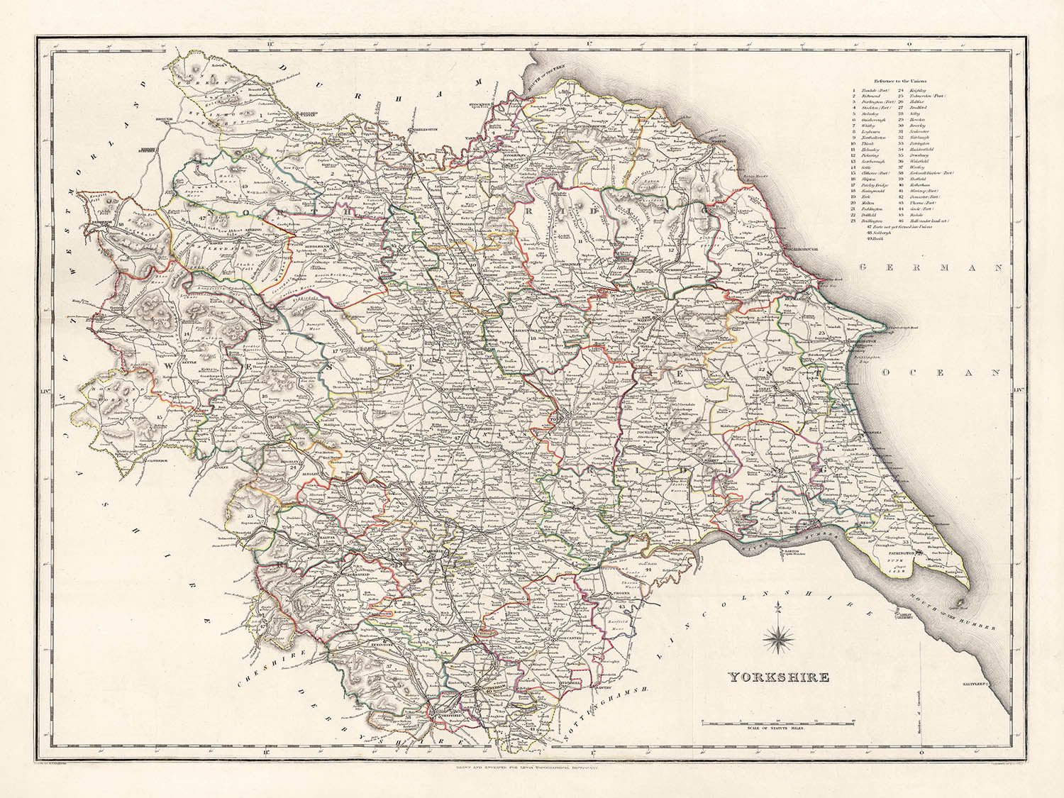


Antigua mapa de Yorkshire por Samuel Lewis, 1844: Leeds, Sheffield, Bradford, Kingston upon Hull y York
Compra 2, Llévate 1 Gratis
Si añades 2 artículos a tu carrito, puedes añadir un tercer producto gratis.
Esto aplica a todos los mapas y obras de arte, incluyendo piezas personalizadas y personalizadas. Puedes pedir 3 de lo mismo, o 3 cosas diferentes.
Esto equivale a un descuento del 33%, que será el mayor descuento disponible en mi tienda este año.
¡Aprovecha la oferta y cubre tus paredes con hermosos mapas y arte!
Contáctame si tienes alguna pregunta.
- All taxes and duties included
- Handmade & dispatched in 1-2 days
-
Complimentary gifting & design advice
ⓘ
Complimentary gifting & design advice
Available almost 24/7 on WhatsApp and email — we usually reply within minutes. We can help you:
- Choose a perfectly personalised gift
- Send a digital gift preview to the recipient
- Pick the ideal size for your wall
- Select the right finish and frame
Quick, friendly advice so you can order with confidence.
For last minute gifts, consider buying a digital gift card. We have over 5,000 maps and art prints to choose from.
-
90-day returns & 5-year guarantee
ⓘ
90 días para devolver y reembolsar
Los productos se pueden devolver dentro de los 90 días para un reembolso completo, o cambio por otro producto.
Para artículos personalizados y hechos a medida, podemos ofrecerte crédito en la tienda o una tarjeta de regalo sin fecha de caducidad, ya que no podemos revender pedidos personalizados.
Si tienes alguna pregunta, ponte en contacto. Para más información, consulta nuestra política de devoluciones y cambios.

This is a museum-grade archival print from the original 1844 map — restored in our workshop and made to order on 220gsm archival matte paper or 400gsm artist's cotton canvas with pigment inks.
Professional framing & free personalisation available
1. Choose a size
2. Frame & personalise your map
Make your map unique with framing, hand-drawn customisation, vintage ageing, pop art text, unique 3D styling and more.


Mensaje de regalo y acabado personalizado

Si deseas agregar un mensaje de regalo, o un acabado (rompecabezas, tablero de aluminio, etc.) que no esté disponible aquí, por favor solicítalo en la "nota del pedido" cuando realices la compra.
Cada pedido es hecho a medida, así que si necesitas que el tamaño se ajuste ligeramente, o que se imprima en un material inusual, háznoslo saber. Hemos realizado miles de pedidos personalizados a lo largo de los años, así que hay (casi) nada que no podamos gestionar.
También puedes contactarnos antes de hacer tu pedido, ¡si lo prefieres!

- Handmade locally. No import duty or tax
- FREE worldwide delivery
- 90-day returns & 5-year product guarantee
- Questions? WhatsApp me any time
Own a piece of history
7,000+ 5 star reviews


Retrocede en el tiempo con este impresionante y meticulosamente detallado mapa de Yorkshire de 1844, elaborado por el reverenciado cartógrafo Samuel Lewis. Esta obra de arte representa meticulosamente los límites históricos del condado de Yorkshire en una época en la que muchas de sus ciudades y pueblos estaban en las primeras etapas de su ascenso industrial. Es una ventana a una era pasada, donde algunas ciudades modernas pueden no haber existido aún, o haber existido bajo un nombre diferente, proporcionando una narrativa intrigante sobre el desarrollo de esta región históricamente rica.
Esta impresionante pieza no solo tiene un inmenso valor histórico, sino que también sirve como un excelente punto de conversación. Ya sea la profunda transformación de Leeds de un modesto municipio de mercado a una bulliciosa ciudad industrial o el encanto perdurable de York, este mapa ofrece una fascinante visión del pasado de Yorkshire. Es una pieza perfecta para historiadores, cartógrafos o cualquier persona interesada en el rico tapiz del pasado de Yorkshire. La estética atemporal del mapa lo convierte en una excelente adición a cualquier decoración.
Ciudades y pueblos notables:- Leeds (siglo V): Leeds era un pequeño municipio señorial en el siglo XIII, y en los siglos que siguieron, se expandió y desarrolló en un importante centro de producción y comercio de lana.
- Sheffield (circa siglo VIII): Conocida por su papel significativo en la Revolución Industrial, Sheffield comenzó como una pequeña aldea centrada alrededor del Castillo de Sheffield.
- Bradford (Edad Media): Bradford creció rápidamente durante el siglo XIX como un centro internacional de fabricación textil, particularmente de lana.
- Kingston upon Hull (siglo XII): Fundada por Eduardo I, Hull ha sido un pueblo de mercado, puerto de suministros militares, centro comercial y metrópoli industrial.
- York (71 d.C.): Fundada por los romanos como Eboracum, York fue la capital de la provincia romana de Britannia Inferior.
- Wakefield (Carta de Wakefield de 1203): Wakefield fue apodada la "Merrie City" en la Edad Media y fue históricamente la capital del West Riding de Yorkshire.
- Doncaster (siglo I d.C.): Originalmente un fuerte romano ocupado llamado Danum, Doncaster ha sido durante mucho tiempo una zona rica debido a su importancia estratégica en el río Don.
- Rotherham (siglo IX): En la Edad Media, Rotherham fue un centro clave de la industria del hierro y más tarde se convirtió en el principal campo de carbón del sur de Yorkshire.
- Halifax (siglo XII): Halifax es conocida por su rica historia en lana, su impresionante arquitectura victoriana y el único Piece Hall.
- Barnsley (Edad Media): Barnsley se convirtió en un centro de producción de lino en Inglaterra, impulsada por su acceso al carbón y al hierro.
- Huddersfield (1066): Huddersfield era un pueblo de mercado conocido por su papel en la Revolución Industrial y por ser el lugar de nacimiento de la liga de rugby.
- Harrogate (siglo XVI): Un popular destino turístico y ciudad balneario, sus manantiales fueron descubiertos en el siglo XVI.
- Scarborough (966 d.C.): Esta histórica ciudad costera en la costa del Mar del Norte es el primer balneario de Gran Bretaña.
- Batley (Finales de la Edad Media): Durante la Revolución Industrial, Batley fue uno de los principales centros de shoddy y mungo, un tejido barato hecho de trapos de lana reciclados o triturados.
- Keighley (Edad Media): Los molinos de Keighley producían textiles para equipar a los soldados, contribuyendo en gran medida al esfuerzo bélico durante las Guerras Napoleónicas.
- Castleford (Época romana): La historia de Castleford se remonta a la época romana, cuando se llamaba Lagentium.
- Pontefract (1086): Pontefract era un importante pueblo de mercado con un castillo real en la Edad Media.
- Wetherby (Siglo XII): Wetherby era un punto de parada para viajar entre Londres, el Norte y Escocia.
- Beverley (Siglo VII): Beverley era un lugar de peregrinación para muchos, habiendo sido un santuario para criminales en la Edad Media.
- Middlesbrough (1830): Middlesbrough era una granja que se convirtió en un gigante industrial debido a las industrias del carbón y el hierro.
- Pocklington (Siglo I d.C.): Conocido como la "Puerta de los Yorkshire Wolds", Pocklington es un antiguo pueblo de mercado, fundado por los ángulos.
- Ilkley (Época Romana): Ilkley era un fuerte romano, y hoy es famoso por su páramo.
- Northallerton (Época Romana): Los romanos tenían una estación de señales aquí y los vikingos fueron quienes le dieron su nombre.
- Richmond (1071): El castillo de Richmond, construido en 1071, tuvo una gran influencia en el desarrollo de la ciudad de Richmond.
- Selby (Siglo XIV): Selby tiene una rica historia marítima y es el lugar de nacimiento del Rey Enrique I de Inglaterra.
- Hornsea (Siglo XII): Un pequeño pueblo costero, Hornsea es conocido por su encanto de la era victoriana.
- Hedon (Siglo XII): Hedon era un importante puerto comercial, cuyas fundaciones aún son visibles hoy en día.
- Howden (Siglo VII): Es un histórico pueblo de mercado con una hermosa Minster que una vez fue un importante centro eclesiástico.
- Knaresborough (1086): El castillo de Knaresborough data de la época normanda, y la ciudad está llena de fascinante historia.
- Skipton (1086): Skipton, la "Puerta de los Dales", tiene un castillo medieval bien conservado.
- Parque Nacional de los Yorkshire Dales: Establecido en 1954, el parque es famoso por sus impresionantes paisajes, rica herencia cultural y diversa fauna.
- Los North York Moors: Un parque nacional con una de las mayores extensiones de páramo de brezo en el Reino Unido.
- Río Ouse y Río Aire: Dos ríos importantes que fluyen a través de Yorkshire, con caminos pintorescos y mucha vida silvestre.
- Páramo de Ilkley: Conocido por su hábitat de tierras altas y restos arqueológicos, es un destino popular para caminar y escalar rocas.
- Flamborough Head: Una de las áreas más espectaculares de acantilados de tiza en Gran Bretaña, alberga uno de los mayores sitios de anidación de aves marinas.
- La Guerra de 1812 (1812-1815): Este conflicto involucró a muchos soldados de Yorkshire, incluidos regimientos de Hull y Halifax.
- Levantamientos Ludditas (1811-1816): Escaramuzas entre el Ejército Británico y trabajadores que protestaban contra el uso de maquinaria en las industrias de lana y algodón.
- Apertura del Canal de Leeds y Liverpool (1816): Esta importante ruta de transporte proporcionó un impulso económico a las ciudades y pueblos a lo largo de su camino.
- Formación del Yorkshire County Cricket Club (1863): Fundado el 8 de enero, desde entonces se ha convertido en uno de los clubes de cricket más exitosos de Inglaterra.
- La Gran Ley de Reforma (1832): Muchas ciudades de Yorkshire, incluidas Leeds y Sheffield, obtuvieron representación en el Parlamento como resultado de esta ley.
- Fundación de Middlesbrough (1830): Middlesbrough era una granja que se transformó en un gigante industrial debido a las industrias del carbón y el hierro.
Por favor, verifica las imágenes para asegurarte de que un pueblo o lugar específico se muestra en este mapa. También puedes ponerte en contacto y pedirnos que verifiquemos el mapa por ti.
Este mapa se ve genial en todos los tamaños: 12x16in (30.5x41cm), 18x24in (45.5x61cm), 16x20in (40.5x51cm), 24x36in (61x91.5cm), 30x40in (76x101.5cm), 37x50in (94x127cm), 45x60in (114x152.5cm) y 52x70in (132x178cm), pero se ve aún mejor cuando se imprime en grande.
Puedo crear impresiones grandes y hermosas de este mapa de hasta 50in (127cm). Por favor, ponte en contacto si buscas opciones de enmarcado más grandes, personalizadas o diferentes.
El modelo en las imágenes del anuncio sostiene la versión de este mapa de 18x24in (45.5x61cm).
La quinta imagen del anuncio muestra un ejemplo de mi servicio de personalización de mapas.
Las etiquetas en este mapa son muy pequeñas en 12x16in (30.5x41cm). El mapa sigue siendo muy atractivo, pero puede que tengas dificultades para leer las letras más pequeñas. Por favor, compra un mapa más grande si es importante poder leer el mapa fácilmente.
Si buscas algo ligeramente diferente, echa un vistazo a mi colección de mapas del Reino Unido e Irlanda.
Por favor, contáctame para verificar si una ubicación, hito o característica específica está mostrada en este mapa.
Este sería un maravilloso regalo de cumpleaños, Navidad, Día del Padre, despedida laboral, aniversario o inauguración de casa para alguien de las áreas cubiertas por este mapa.
Este mapa está disponible como una impresión giclée en papel mate libre de ácido y de archivo, o puedes comprarlo enmarcado. El marco es un bonito y simple marco negro que se adapta a la mayoría de las estéticas. Por favor, ponte en contacto si deseas un color o material de marco diferente. Mis marcos están envidriados con acrílico de grado museo superclaro (perspex/acrylite), que es significativamente menos reflectante que el vidrio, más seguro, y siempre llegará en perfectas condiciones.
This map is also available as a float framed canvas, sometimes known as a shadow gap framed canvas or canvas floater. The map is printed on artist's cotton canvas and then stretched over a handmade box frame. We then "float" the canvas inside a wooden frame, which is available in a range of colours (black, dark brown, oak, antique gold and white). This is a wonderful way to present a map without glazing in front. See some examples of float framed canvas maps and explore the differences between my different finishes.
For something truly unique, this map is also available in "Unique 3D", our trademarked process that dramatically transforms the map so that it has a wonderful sense of depth. We combine the original map with detailed topography and elevation data, so that mountains and the terrain really "pop". For more info and examples of 3D maps, check my Unique 3D page.
Para la mayoría de los pedidos, el tiempo de entrega es de aproximadamente 3 días laborables. Los productos personalizados y a medida tardan más, ya que tengo que hacer la personalización y enviártelo para su aprobación, lo cual suele tardar 1 o 2 días.
Tenga en cuenta que los pedidos enmarcados muy grandes suelen tardar más en fabricarse y entregarse.
Si necesitas que tu pedido llegue para una fecha determinada, por favor contáctame antes de hacer el pedido para que podamos encontrar la mejor manera de asegurarnos de que recibas tu pedido a tiempo.
Imprimo y enmarco mapas y obras de arte en 23 países alrededor del mundo. Esto significa que tu pedido se fabricará localmente, lo que reduce el tiempo de entrega y asegura que no se dañe durante el envío. Nunca pagarás aranceles de aduana o impuestos de importación, y pondremos menos CO2 en el aire.
Todos mis mapas y impresiones artísticas están bien empaquetados y enviados en un tubo resistente si no están enmarcados, o rodeados de espuma si están enmarcados.
Intento enviar todos los pedidos dentro de 1 o 2 días después de recibir tu pedido, aunque algunos productos (como mascarillas, tazas y bolsas de tela) pueden tardar más en fabricarse.
Si seleccionas Entrega Exprés al finalizar la compra, priorizaremos tu pedido y lo enviaremos por mensajería de 1 día (Fedex, DHL, UPS, Parcelforce).
La entrega al día siguiente también está disponible en algunos países (EE. UU., Reino Unido, Singapur, EAU), pero por favor intenta hacer tu pedido temprano en el día para que podamos enviarlo a tiempo.
Mi marco estándar es un marco de madera de fresno negro estilo galería. Es simple y tiene un aspecto bastante moderno. Mi marco estándar tiene alrededor de 20 mm (0.8 in) de ancho.
Utilizo acrílico super claro (perspex/acrylite) para el vidrio del marco. Es más ligero y seguro que el vidrio, y se ve mejor, ya que la reflectividad es menor.
Seis colores de marco estándar están disponibles de forma gratuita (negro, marrón oscuro, gris oscuro, roble, blanco y oro antiguo).El enmarcado y montaje/matizado personalizado está disponible si buscas algo diferente.
La mayoría de los mapas, arte e ilustraciones también están disponibles como un lienzo enmarcado. Utilizamos lienzo de algodón mate (no brillante), lo estiramos sobre un marco de madera de caja de origen sostenible, y luego 'flotamos' la pieza dentro de un marco de madera. El resultado final es bastante hermoso, y no hay cristal que se interponga.
Todos los marcos se proporcionan "listos para colgar", con una cuerda o soportes en la parte posterior. Los marcos muy grandes tendrán placas de colgar de alta resistencia y/o un listón de montaje. Si tienes alguna pregunta, por favor ponte en contacto.
Mira algunos ejemplos de mis mapas enmarcados y mapas en lienzo enmarcados.
Alternativamente, también puedo proporcionar mapas antiguos y obras de arte en lienzo, tablero de espuma, papel de algodón y otros materiales.
Si deseas enmarcar tu mapa o obra de arte tú mismo, por favor lee mi guía de tamaños primero.
Algunos de mis mapas antiguos ahora están disponibles como lienzos enmarcados. Por favor contáctame si deseas pedir un tamaño que no está disponible en mi tienda.
Los mapas antiguos en lienzo son una alternativa interesante a los mapas enmarcados convencionalmente. Dependiendo de tu gusto personal y la decoración de la habitación, los mapas en lienzo pueden "destacar" un poco más que un mapa enmarcado.
Mis mapas son reproducciones de mapas originales de altísima calidad.
Obtengo mapas originales y raros de bibliotecas, casas de subastas y colecciones privadas de todo el mundo, los restauro en mi taller de Londres y luego uso tintas e impresoras giclée especializadas para crear hermosos mapas que lucen incluso mejor que el original.
Mis mapas están impresos en papel de archivo mate (no brillante) sin ácido que se siente de muy alta calidad y casi como una tarjeta. En términos técnicos, el peso/grosor del papel es de 10 mil/200 g/m². Es perfecto para enmarcar.
Imprimo con tintas pigmentadas Epson ultrachrome giclée UV resistentes a la decoloración, algunas de las mejores tintas que puedes encontrar.
yo también puedo hacer mapas sobre lienzo, trapo de algodón y otros materiales exóticos.
Obtenga más información sobre The Unique Maps Co..
Personalización de mapas
Si está buscando el regalo perfecto de aniversario o inauguración de la casa, puedo personalizar su mapa para hacerlo verdaderamente único. Por ejemplo, puedo agregar un mensaje corto, resaltar una ubicación importante o agregar el escudo de armas de su familia.
Las opciones son casi infinitas. Por favor mira mi página de personalización de mapas para ver algunos maravillosos ejemplos de lo que es posible.
Para pedir un mapa personalizado, seleccione "personalizar su mapa" antes de agregarlo a su carrito.
Ponerse en contacto si buscas personalizaciones y personalizaciones más complejas.
Envejecimiento del mapa
A lo largo de los años, los clientes me han preguntado cientos de veces si podían comprar un mapa que se viera uniforme. más viejo.
Bueno, ahora puedes hacerlo seleccionando Envejecido antes de agregar un mapa a tu carrito.
Todas las fotografías de productos que ve en esta página muestran el mapa en su forma original. Así es como se ve el mapa hoy.
Si selecciona Envejecido, envejeceré su mapa a mano, usando un proceso especial y único desarrollado a través de años de estudiar mapas antiguos, hablar con investigadores para comprender la química del envejecimiento del papel y, por supuesto... ¡mucha práctica!
Si no estás seguro, quédate con el color original del mapa. Si quieres algo un poco más oscuro y más viejo buscando, opte por Envejecido.
Si no estás satisfecho con tu pedido por cualquier motivo, contáctame para un reembolso sin complicaciones. Por favor, consulta nuestra política de devoluciones y reembolsos para más información.
Estoy muy seguro de que te gustará tu mapa o impresión artística restaurada. He estado haciendo esto desde 1984. Soy un vendedor de 5 estrellas en Etsy. He vendido decenas de miles de mapas e impresiones artísticas y tengo más de 5,000 opiniones reales de 5 estrellas.
Utilizo un proceso único para restaurar mapas y obras de arte que consume mucho tiempo y mano de obra. Buscar los mapas e ilustraciones originales puede llevar meses. Utilizo tecnología de última generación y extremadamente cara para escanear y restaurarlos. Como resultado, garantizo que mis mapas e impresiones artísticas son superiores a los demás - por eso puedo ofrecer un reembolso sin complicaciones.
Casi todos mis mapas e impresiones artísticas se ven increíbles en tamaños grandes (200cm, 6.5ft+) y también puedo enmarcarlos y entregártelos a través de un servicio de mensajería especial para tamaños grandes. Contáctame para discutir tus necesidades específicas.
Or try searching for something!


