


Old Map of Postwar Occupation and Denazification in Germany, 1946
- All taxes and duties included
- Handmade & dispatched in 1-2 days
-
90 day money back guarantee
ⓘ
90 días para devolver y reembolsar
Los productos se pueden devolver dentro de los 90 días para un reembolso completo, o cambio por otro producto.
Para artículos personalizados y hechos a medida, podemos ofrecerte crédito en la tienda o una tarjeta de regalo sin fecha de caducidad, ya que no podemos revender pedidos personalizados.
Si tienes alguna pregunta, ponte en contacto. Para más información, consulta nuestra política de devoluciones y cambios.

My maps are rare, museum-grade, restored old maps sourced from libraries, auction houses and private collections across the globe.
Framing & free personalisation available
1. Select your size
2. Frame & personalise your map
There is limited framing & personalisation capacity available. Order by 10am tomorrow for Christmas delivery.


Mensaje de regalo y acabado personalizado

Si deseas agregar un mensaje de regalo, o un acabado (rompecabezas, tablero de aluminio, etc.) que no esté disponible aquí, por favor solicítalo en la "nota del pedido" cuando realices la compra.
Cada pedido es hecho a medida, así que si necesitas que el tamaño se ajuste ligeramente, o que se imprima en un material inusual, háznoslo saber. Hemos realizado miles de pedidos personalizados a lo largo de los años, así que hay (casi) nada que no podamos gestionar.
También puedes contactarnos antes de hacer tu pedido, ¡si lo prefieres!

- Handmade locally. No import duty or tax
- FREE Delivery by Christmas
- Love it or your money back (90 days)
- Questions? WhatsApp me any time
Own a piece of history
5,000+ 5 star reviews


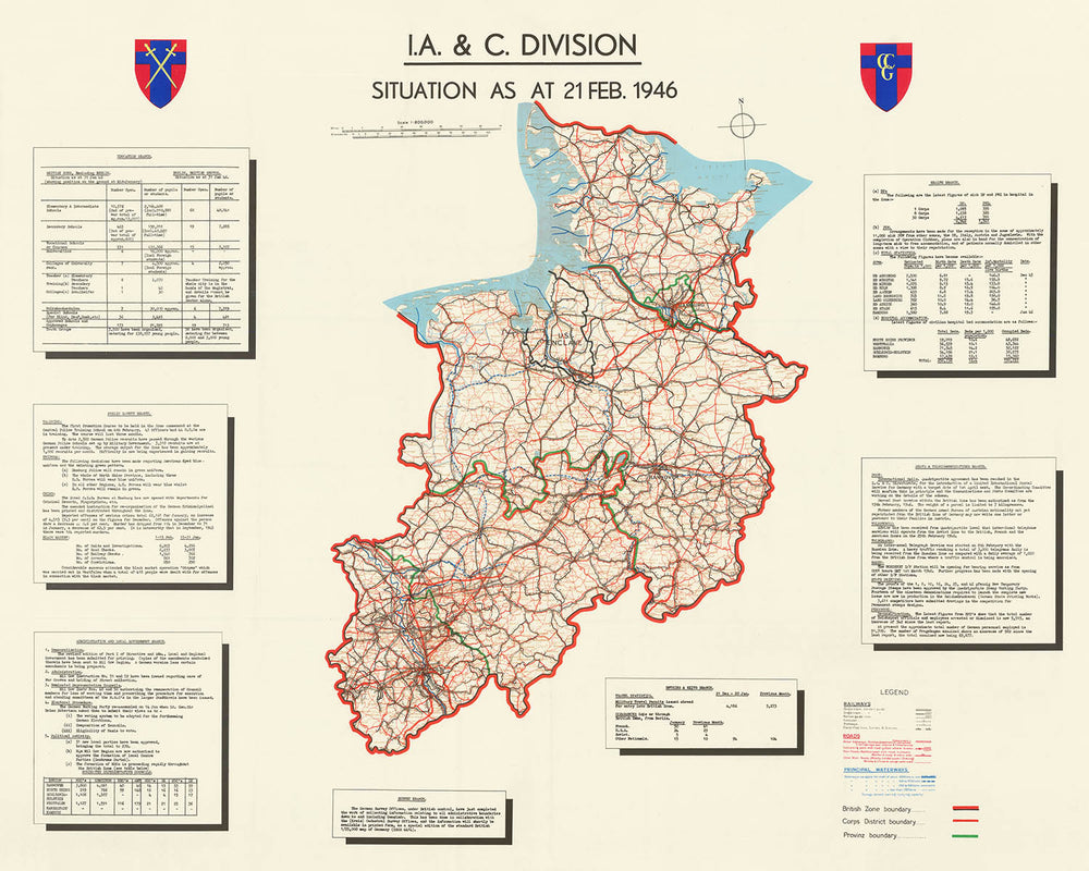
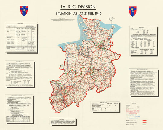
Step into a pivotal moment in twentieth-century history with this exceptional map, "I.A. & C. Division Situation As At 21 Feb. 1946," a rare artifact from the immediate aftermath of the Second World War. Created by the British Information and Civil Division, this map offers a detailed and authoritative view of the British Zone of Occupation in northwest Germany, a region undergoing profound transformation. Spanning from Cologne in the south to the Danish border in the north, and encompassing such major cities as Hamburg, Hannover, and Bremen, the map captures the complexity of governance, reconstruction, and denazification efforts at a time when Europe was striving to rebuild from the ashes of conflict.
What sets this map apart is its remarkable thematic depth. Far more than a simple geographical reference, it serves as a comprehensive administrative and infrastructural overview, meticulously charting the region’s railways, roads, and waterways. Each element is clearly differentiated—railways by track type and electrification, roads by width and construction, and waterways by their carrying capacity—providing a window into the logistical backbone essential for both military and civilian life. These details illuminate the immense challenge of restoring normalcy, facilitating movement, and reviving trade in a landscape scarred by war.
Equally compelling are the boxed summaries and tables that frame the map, offering a granular snapshot of daily life and governance in early 1946. The British authorities, through their various branches—Education, Public Safety, Health, Administration, Survey, and more—monitored everything from school attendance and hospital bed availability to crime rates and the flow of displaced persons. These statistics and reports bring to life the multifaceted responsibilities of the occupying powers, revealing their efforts to democratize local governance, maintain order, and care for a population deeply affected by years of conflict and upheaval.
The map’s historical significance is profound. It not only delineates the British Zone and the notable U.S. Enclave within it but also marks the administrative boundaries of Corps Districts and Provinces, underscoring the careful organization required to manage such a vast and devastated territory. The presence of key cities like Hamburg, Cologne, and Hannover, alongside crucial transportation routes, speaks to the strategic importance of this region in the broader context of European recovery. The inclusion of data on war graves, political activities, and the status of communication networks further enriches our understanding of the immediate postwar environment.
For collectors, historians, or anyone with an appreciation for the nuanced tapestry of European history, this map is a rare and invaluable piece. Its rarity is underscored by the fact that so few examples are known to exist, making it not only a window into the past but also a testament to the extraordinary efforts of those tasked with rebuilding a nation. Displaying this map is an invitation to reflect on the resilience, complexity, and hope that defined Germany’s journey from war to peace—a story etched into every line, symbol, and annotation on this remarkable document.
Places on this map
- Hamburg
- Hannover
- Cologne (Köln)
- Bremen
- Lübeck
- Kiel
- Osnabrück
- Münster
- Oldenburg
- Flensburg
- Wilhelmshaven
- Bielefeld
- Braunschweig (Brunswick)
- Göttingen
- Cuxhaven
- Emden
- Bremerhaven
- Lüneburg
- Minden
- Hildesheim
Notable Features & Landmarks
- Clearly delineated British Zone of Occupation boundary
- U.S. Enclave marked within the British Zone
- Detailed railway network, with distinctions for number of tracks, gauge, electrification, and tunnels
- Road network categorized by type (motor highways, main roads, etc.) and width
- Waterways classified by navigable craft capacity
- Administrative boundaries: Corps Districts and Provinz boundaries
- Boxed summaries for each administrative branch: Education, Public Safety, Administration & Local Government, Survey, Health, Posts & Telecommunications, Entries & Exits
- Legend explaining map symbols for infrastructure and boundaries
- Tables and text blocks with statistics and situational reports as of January and February 1946
- Data on schools, students, and educational infrastructure
- Information on police training, uniforms, crime, and black market activity
- Notes on democratization, administrative directives, war graves, and political activities
- Survey branch notes on completion of administrative boundary information
- Health statistics: hospital beds, birth/death rates, DPs, and POWs
- Postal service, telephone, and radio status
- Travel statistics: permits issued and clearances granted
- Map scale and orientation
- Surrounding regions and neighboring countries, including Denmark
- Key transportation routes for military and civilian movement
- Emphasis on infrastructure vital for reconstruction and occupation logistics
Historical and design context
- Name of the map: I.A. & C. Division Situation As At 21 Feb. 1946 (Second World War - Postwar Occupation of Germany - Denazification)
- Date created: 21 February 1946
- Mapmaker/publisher: Information and Civil Division (I.A. & C. Division), British administration, post-World War II
- The I.A. & C. Division was a British administrative body responsible for overseeing civilian life, infrastructure, and governance in the British Zone of Occupation in postwar Germany.
- Covers northwest Germany, from Cologne in the south to the Danish border in the north, including major cities and regions within the British Zone
- Thematic, highly detailed, with a comprehensive legend; includes tables and boxed summaries for each administrative branch; uses color and symbols to differentiate infrastructure and boundaries
- Provides a snapshot of the immediate postwar situation in British-occupied Germany, including efforts at reconstruction, denazification, and democratization
- Highlights the administrative complexity and the multifaceted challenges faced by the occupying authorities
- Rare artifact: Very few known copies exist; part of a set of three maps with different dates
- Offers insight into the infrastructure, governance, and humanitarian situation in Germany shortly after WWII, making it valuable for historians studying the occupation and reconstruction period
Please double check the images to make sure that a specific town or place is shown on this map. You can also get in touch and ask us to check the map for you.
This map looks great at every size, but I always recommend going for a larger size if you have space. That way you can easily make out all of the details.
This map looks amazing at sizes all the way up to 100in (250cm). If you are looking for a larger map, please get in touch.
Please note: the labels on this map are hard to read if you order a map that is 20in (50cm) or smaller. The map is still very attractive, but if you would like to read the map easily, please buy a larger size.
The model in the listing images is holding the 16x20in (40x50cm) version of this map.
The fifth listing image shows an example of my map personalisation service.
If you’re looking for something slightly different, check out my collection of the best old maps to see if something else catches your eye.
Please contact me to check if a certain location, landmark or feature is shown on this map.
This would make a wonderful birthday, Christmas, Father's Day, work leaving, anniversary or housewarming gift for someone from the areas covered by this map.
This map is available as a giclée print on acid free archival matte paper, or you can buy it framed. The frame is a nice, simple black frame that suits most aesthetics. Please get in touch if you'd like a different frame colour or material. My frames are glazed with super-clear museum-grade acrylic (perspex/acrylite), which is significantly less reflective than glass, safer, and will always arrive in perfect condition.
This map is also available as a float framed canvas, sometimes known as a shadow gap framed canvas or canvas floater. The map is printed on artist's cotton canvas and then stretched over a handmade box frame. We then "float" the canvas inside a wooden frame, which is available in a range of colours (black, dark brown, oak, antique gold and white). This is a wonderful way to present a map without glazing in front. See some examples of float framed canvas maps and explore the differences between my different finishes.
For something truly unique, this map is also available in "Unique 3D", our trademarked process that dramatically transforms the map so that it has a wonderful sense of depth. We combine the original map with detailed topography and elevation data, so that mountains and the terrain really "pop". For more info and examples of 3D maps, check my Unique 3D page.
Para la mayoría de los pedidos, el tiempo de entrega es de aproximadamente 3 días laborables. Los productos personalizados y a medida tardan más, ya que tengo que hacer la personalización y enviártelo para su aprobación, lo cual suele tardar 1 o 2 días.
Tenga en cuenta que los pedidos enmarcados muy grandes suelen tardar más en fabricarse y entregarse.
Si necesitas que tu pedido llegue para una fecha determinada, por favor contáctame antes de hacer el pedido para que podamos encontrar la mejor manera de asegurarnos de que recibas tu pedido a tiempo.
Imprimo y enmarco mapas y obras de arte en 23 países alrededor del mundo. Esto significa que tu pedido se fabricará localmente, lo que reduce el tiempo de entrega y asegura que no se dañe durante el envío. Nunca pagarás aranceles de aduana o impuestos de importación, y pondremos menos CO2 en el aire.
Todos mis mapas y impresiones artísticas están bien empaquetados y enviados en un tubo resistente si no están enmarcados, o rodeados de espuma si están enmarcados.
Intento enviar todos los pedidos dentro de 1 o 2 días después de recibir tu pedido, aunque algunos productos (como mascarillas, tazas y bolsas de tela) pueden tardar más en fabricarse.
Si seleccionas Entrega Exprés al finalizar la compra, priorizaremos tu pedido y lo enviaremos por mensajería de 1 día (Fedex, DHL, UPS, Parcelforce).
La entrega al día siguiente también está disponible en algunos países (EE. UU., Reino Unido, Singapur, EAU), pero por favor intenta hacer tu pedido temprano en el día para que podamos enviarlo a tiempo.
Mi marco estándar es un marco de madera de fresno negro estilo galería. Es simple y tiene un aspecto bastante moderno. Mi marco estándar tiene alrededor de 20 mm (0.8 in) de ancho.
Utilizo acrílico super claro (perspex/acrylite) para el vidrio del marco. Es más ligero y seguro que el vidrio, y se ve mejor, ya que la reflectividad es menor.
Seis colores de marco estándar están disponibles de forma gratuita (negro, marrón oscuro, gris oscuro, roble, blanco y oro antiguo).El enmarcado y montaje/matizado personalizado está disponible si buscas algo diferente.
La mayoría de los mapas, arte e ilustraciones también están disponibles como un lienzo enmarcado. Utilizamos lienzo de algodón mate (no brillante), lo estiramos sobre un marco de madera de caja de origen sostenible, y luego 'flotamos' la pieza dentro de un marco de madera. El resultado final es bastante hermoso, y no hay cristal que se interponga.
Todos los marcos se proporcionan "listos para colgar", con una cuerda o soportes en la parte posterior. Los marcos muy grandes tendrán placas de colgar de alta resistencia y/o un listón de montaje. Si tienes alguna pregunta, por favor ponte en contacto.
Mira algunos ejemplos de mis mapas enmarcados y mapas en lienzo enmarcados.
Alternativamente, también puedo proporcionar mapas antiguos y obras de arte en lienzo, tablero de espuma, papel de algodón y otros materiales.
Si deseas enmarcar tu mapa o obra de arte tú mismo, por favor lee mi guía de tamaños primero.
Algunos de mis mapas antiguos ahora están disponibles como lienzos enmarcados. Por favor contáctame si deseas pedir un tamaño que no está disponible en mi tienda.
Los mapas antiguos en lienzo son una alternativa interesante a los mapas enmarcados convencionalmente. Dependiendo de tu gusto personal y la decoración de la habitación, los mapas en lienzo pueden "destacar" un poco más que un mapa enmarcado.
Mis mapas son reproducciones de mapas originales de altísima calidad.
Obtengo mapas originales y raros de bibliotecas, casas de subastas y colecciones privadas de todo el mundo, los restauro en mi taller de Londres y luego uso tintas e impresoras giclée especializadas para crear hermosos mapas que lucen incluso mejor que el original.
Mis mapas están impresos en papel de archivo mate (no brillante) sin ácido que se siente de muy alta calidad y casi como una tarjeta. En términos técnicos, el peso/grosor del papel es de 10 mil/200 g/m². Es perfecto para enmarcar.
Imprimo con tintas pigmentadas Epson ultrachrome giclée UV resistentes a la decoloración, algunas de las mejores tintas que puedes encontrar.
yo también puedo hacer mapas sobre lienzo, trapo de algodón y otros materiales exóticos.
Obtenga más información sobre The Unique Maps Co..
Personalización de mapas
Si está buscando el regalo perfecto de aniversario o inauguración de la casa, puedo personalizar su mapa para hacerlo verdaderamente único. Por ejemplo, puedo agregar un mensaje corto, resaltar una ubicación importante o agregar el escudo de armas de su familia.
Las opciones son casi infinitas. Por favor mira mi página de personalización de mapas para ver algunos maravillosos ejemplos de lo que es posible.
Para pedir un mapa personalizado, seleccione "personalizar su mapa" antes de agregarlo a su carrito.
Ponerse en contacto si buscas personalizaciones y personalizaciones más complejas.
Envejecimiento del mapa
A lo largo de los años, los clientes me han preguntado cientos de veces si podían comprar un mapa que se viera uniforme. más viejo.
Bueno, ahora puedes hacerlo seleccionando Envejecido antes de agregar un mapa a tu carrito.
Todas las fotografías de productos que ve en esta página muestran el mapa en su forma original. Así es como se ve el mapa hoy.
Si selecciona Envejecido, envejeceré su mapa a mano, usando un proceso especial y único desarrollado a través de años de estudiar mapas antiguos, hablar con investigadores para comprender la química del envejecimiento del papel y, por supuesto... ¡mucha práctica!
Si no estás seguro, quédate con el color original del mapa. Si quieres algo un poco más oscuro y más viejo buscando, opte por Envejecido.
Si no estás satisfecho con tu pedido por cualquier motivo, contáctame para un reembolso sin complicaciones. Por favor, consulta nuestra política de devoluciones y reembolsos para más información.
Estoy muy seguro de que te gustará tu mapa o impresión artística restaurada. He estado haciendo esto desde 1984. Soy un vendedor de 5 estrellas en Etsy. He vendido decenas de miles de mapas e impresiones artísticas y tengo más de 5,000 opiniones reales de 5 estrellas.
Utilizo un proceso único para restaurar mapas y obras de arte que consume mucho tiempo y mano de obra. Buscar los mapas e ilustraciones originales puede llevar meses. Utilizo tecnología de última generación y extremadamente cara para escanear y restaurarlos. Como resultado, garantizo que mis mapas e impresiones artísticas son superiores a los demás - por eso puedo ofrecer un reembolso sin complicaciones.
Casi todos mis mapas e impresiones artísticas se ven increíbles en tamaños grandes (200cm, 6.5ft+) y también puedo enmarcarlos y entregártelos a través de un servicio de mensajería especial para tamaños grandes. Contáctame para discutir tus necesidades específicas.
Or try searching for something!


