


Mapa antiguo de la península arábiga de Ptolomeo, 1482: Arabia Feliz, Mar Rojo, Golfo Pérsico, Carmania
20% de descuento en 2 — 33% de descuento en 3
Añade dos artículos elegibles a tu carrito para recibir 20% de descuento. Añade un tercero y será complementario (equivalente a 33% de descuento al comprar tres).
No se necesita código — la oferta se aplica automáticamente al finalizar la compra.
Válido en todos los mapas estándar y impresiones de arte fino. Puedes mezclar y combinar cualquier diseño.
Si deseas enviar artículos a múltiples direcciones, por favor contáctanos antes de realizar tu pedido.
Las comisiones personalizadas y a medida están excluidas.
Contáctanos si tienes alguna pregunta

Restaurado a partir del mapa original de 1482 e impreso en calidad museo. Leer la historia detrás de este mapa
Choose your size
Choose your finish


(Más información)
Mensaje de regalo y acabado personalizado

Si deseas agregar un mensaje de regalo, o un acabado (rompecabezas, tablero de aluminio, etc.) que no esté disponible aquí, por favor solicítalo en la "nota del pedido" cuando realices la compra.
Cada pedido es hecho a medida, así que si necesitas que el tamaño se ajuste ligeramente, o que se imprima en un material inusual, háznoslo saber. Hemos realizado miles de pedidos personalizados a lo largo de los años, así que hay (casi) nada que no podamos gestionar.
También puedes contactarnos antes de hacer tu pedido, ¡si lo prefieres!

- Hecho localmente. Entrega segura
- Sin aranceles ni cargos ocultos
- ¿Necesitas ayuda? Llámanos o mensaje por WhatsApp
Own a piece of history
8,000+ five-star reviews


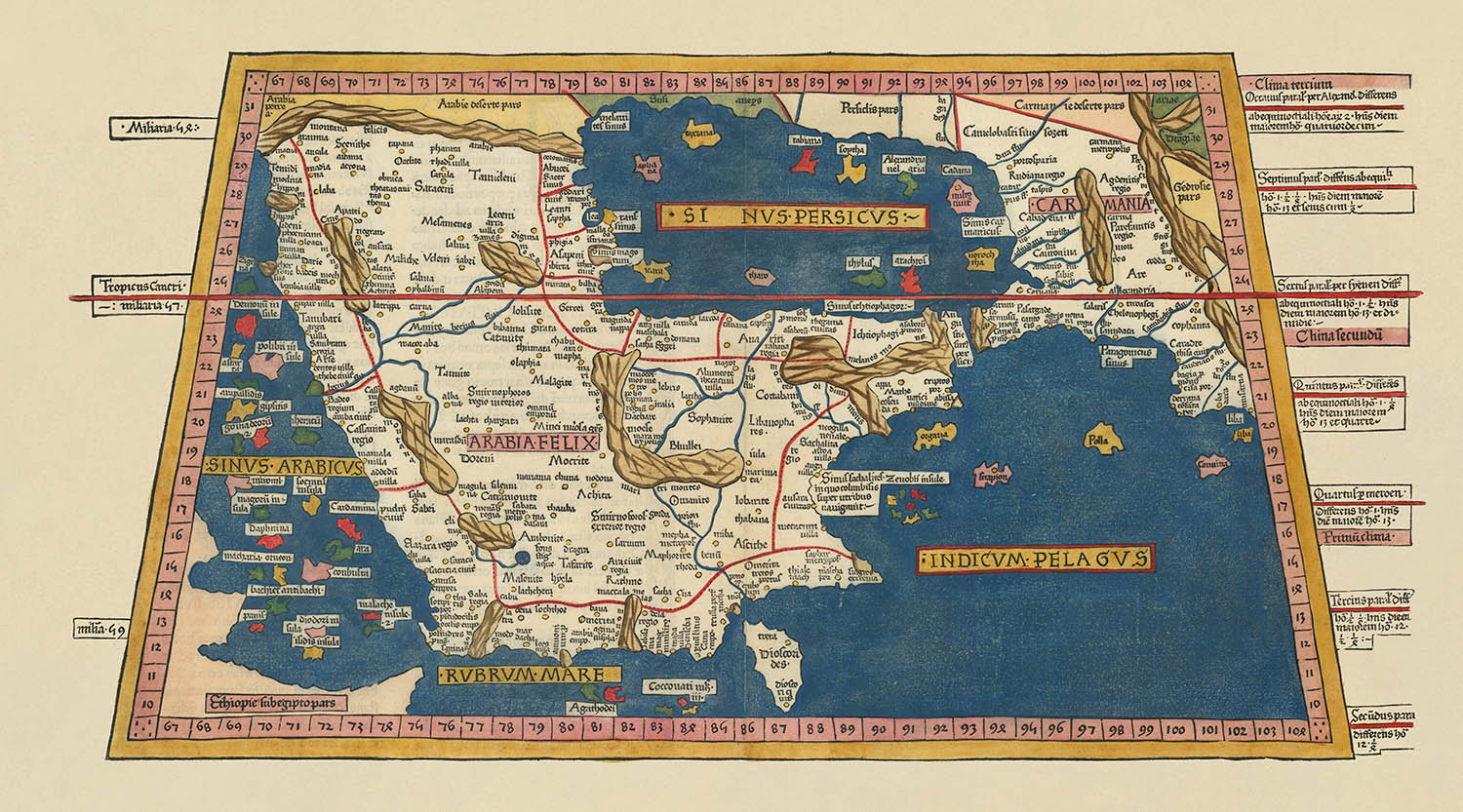
Adéntrese en el luminoso mundo de la cartografía renacentista con la extraordinaria [Arabian Peninsula] [Sexta Asie Tabula, Arabia Felix.], un mapa cuyo...
Seguir leyendoAdéntrese en el luminoso mundo de la cartografía renacentista con la extraordinaria [Arabian Peninsula] [Sexta Asie Tabula, Arabia Felix.], un mapa cuyo propio nombre evoca las tierras legendarias y la ambición erudita de su época. Elaborado en 1482 para la célebre edición de Ulm de la Geographia de Ptolomeo, este mapa es una verdadera rareza: la representación impresa en madera más antigua de la península arábiga, y una culminación de la cartografía del siglo XV. Sus rótulos, en el latín erudito de la época, le invitan a explorar un mundo a la vez familiar y maravillosamente reinventado, donde los límites del conocimiento se estaban redibujando con cada pasada de la prensa.
El genio detrás de esta obra maestra es una confluencia de grandes mentes. La cartografía fundacional es obra de Claudio Ptolomeo, el polímatta griego de la Antigüedad cuya Geographia redefinió la ciencia de la cartografía. El editor de la edición de Ulm, Lienhart Holle, dio vida a la visión de Ptolomeo al norte de los Alpes por primera vez, empleando la innovadora técnica de impresión en madera y el arte de Johannes Schnitzer. Su colaboración produjo no solo un mapa, sino una obra de arte, concebida para ser coloreada a mano con el raro y precioso pigmento lapislázuli, procedente de las célebres minas de Afganistán.
Este mapa es tan rico en detalle como en historia. La península arábiga —conocida aquí como Arabia Felix— ocupa un lugar central, rodeada por el azul abrazo del mar Rojo, el golfo de Adén, el mar Arábigo, el golfo de Omán y el golfo Pérsico. La costa está salpicada de islas, y la propia tierra se marca con un mosaico de ciudades y regiones políticas, cada una testimonio de la exhaustiva erudición del cartógrafo. Los bordes del mapa se extienden hasta los antiguos reinos de Etiopía y Carmania, ofreciendo un vistazo de África y Persia tal como las entendía la Europa renacentista.
Un rasgo destacado de este mapa es su uso pionero de una cuadrícula de latitud y longitud, una innovación cartográfica que se remonta al propio Ptolomeo. Este marco geométrico, combinado con los títulos en negrita y los ornamentos decorativos del grabado en madera, aporta tanto rigor científico como gracia estética. Cada detalle, desde la ubicación de las ciudades hasta el etiquetado de los mares, refleja el fervor intelectual de una época en la que el mundo se redescubría a través del prisma de la sabiduría clásica y de la más avanzada tecnología de impresión.
Históricamente, este mapa se sitúa en la encrucijada entre el descubrimiento y la tradición. Surgió en un momento en que Europa se despertaba de nuevo al conocimiento geográfico de la Antigüedad, gracias al redescubrimiento y la traducción al latín de los textos de Ptolomeo. La edición de Ulm fue un acontecimiento editorial monumental, y sus mapas fueron codiciados con entusiasmo tanto por eruditos como por coleccionistas. Hoy, la [Arabian Peninsula] [Sexta Asie Tabula, Arabia Felix.] se celebra no solo por su rareza y belleza, sino también por su influencia perdurable en el arte y la ciencia de la cartografía: una auténtica joya para el coleccionista exigente.
Características y puntos de referencia destacados
- La península arábiga (Arabia Felix) representada en el centro y de forma prominente
- Cuerpos de agua circundantes: mar Rojo, golfo de Adén, mar Arábigo, golfo de Omán y golfo Pérsico (todos rotulados en latín)
- Numerosas islas ilustradas alrededor de la península
- Cuadrícula de latitud y longitud enmarcando el mapa
- Se muestran en los bordes del mapa las fronteras de Etiopía (África) y Carmania (Persia/Irán)
- Unidades políticas y regiones rotuladas (en latín)
- Títulos decorativos en grabado en madera para las principales masas de tierra y cuerpos de agua
Contexto histórico y de diseño
- Nombre del mapa: [Península Arábiga] [Sexta Asie Tabula, Arabia Felix.]
- Fecha de creación: 1482
- Cartógrafo/editor: Claudius Ptolemy (cartografía original), Lienhart Holle (editor, edición de Ulm), grabado en madera por Johannes Schnitzer
- Fuente: edición de Ulm de 1482 de la Geographia de Ptolomeo, el primer atlas impreso al norte de los Alpes y el primero en contener mapas ilustrados grabados en madera
- Innovación de impresión: Primera representación de la Península Arábiga impresa en madera; mares coloreados con el costoso pigmento lapislázuli
- Idioma: Todas las etiquetas están en latín, la lengua académica del siglo XV
- Temas del mapa: Geografía política y física de la Península Arábiga y las regiones circundantes
- Diferencias entre ediciones: la primera edición de 1482 carece de un título impreso sobre la imagen del mapa; los mares están coloreados en azul con lapislázuli; la reedición de 1486 incluye un título impreso y mares marrones
- Rareza: La primera versión del mapa es rara y muy codiciada; precio reciente en subasta superior a $110,000
- Importancia: El mapa más famoso y codiciado del siglo XV de la Península Arábiga; el mapa impreso en madera más antiguo de la región
- Influencia: La Geographia de Ptolomeo reintrodujo la latitud y longitud, la proyección cartográfica y la orientación al norte en la cartografía europea
- Orígenes manuscritos: Basado en un manuscrito de Dominus Nicolaus Germanus, un monje benedictino alemán
- Destaca por: Haber sido concebido para ser coloreado, con instrucciones del editor para su ornamentación
Por favor, compruebe detenidamente las imágenes para asegurarse de que en este mapa se muestra una ciudad o lugar concreto. También puede ponerse en contacto con nosotros y pedirnos que revisemos el mapa por usted.
Este mapa se ve estupendo en cualquier tamaño, pero siempre recomiendo optar por un tamaño mayor si dispone de espacio. Así podrá distinguir fácilmente todos los detalles.
Este mapa se ve impresionante en tamaños de hasta 90in (230cm). Si está buscando un mapa más grande, por favor póngase en contacto.
Este mapa es más ancho que la mayoría de los mapas, por lo que sería una pieza protagonista perfecta sobre una repisa de chimenea, un sofá o un escritorio.
La quinta imagen del listado muestra un ejemplo de mi servicio de personalización de mapas.
Si está buscando algo un poco diferente, eche un vistazo a mi colección de los mejores mapas antiguos para ver si algo más llama su atención.
Por favor, contácteme para comprobar si una determinada ubicación, punto de referencia o rasgo aparece en este mapa.
Sería un regalo maravilloso de cumpleaños, Navidad, Día del Padre, despedida del trabajo, aniversario o inauguración de casa para alguien de las zonas cubiertas por este mapa.
Este mapa está disponible como impresión giclée sobre papel mate de archivo libre de ácido, o puede comprarlo enmarcado. El marco es un marco negro, elegante y sencillo, que se adapta a la mayoría de las estéticas. Por favor, póngase en contacto si desea un color o material de marco diferente. Mis marcos llevan un acristalamiento de acrílico de calidad museo de máxima transparencia (perspex/acrylite), que es considerablemente menos reflectante que el vidrio, más seguro y siempre llegará en perfectas condiciones.
This map is also available as a float framed canvas, sometimes known as a shadow gap framed canvas or canvas floater. The map is printed on artist's cotton canvas and then stretched over a handmade box frame. We then "float" the canvas inside a wooden frame, which is available in a range of colours (black, dark brown, oak, antique gold and white). This is a wonderful way to present a map without glazing in front. See some examples of float framed canvas maps and explore the differences between my different finishes.
For something truly unique, this map is also available in "Unique 3D", our trademarked process that dramatically transforms the map so that it has a wonderful sense of depth. We combine the original map with detailed topography and elevation data, so that mountains and the terrain really "pop". For more info and examples of 3D maps, check my Unique 3D page.
Adéntrese en el luminoso mundo de la cartografía renacentista con la extraordinaria [Arabian Peninsula] [Sexta Asie Tabula, Arabia Felix.], un mapa cuyo propio nombre evoca las tierras legendarias y la ambición erudita de su época. Elaborado en 1482 para la célebre edición de Ulm de la Geographia de Ptolomeo, este mapa es una verdadera rareza: la representación impresa en madera más antigua de la península arábiga, y una culminación de la cartografía del siglo XV. Sus rótulos, en el latín erudito de la época, le invitan a explorar un mundo a la vez familiar y maravillosamente reinventado, donde los límites del conocimiento se estaban redibujando con cada pasada de la prensa.
El genio detrás de esta obra maestra es una confluencia de grandes mentes. La cartografía fundacional es obra de Claudio Ptolomeo, el polímatta griego de la Antigüedad cuya Geographia redefinió la ciencia de la cartografía. El editor de la edición de Ulm, Lienhart Holle, dio vida a la visión de Ptolomeo al norte de los Alpes por primera vez, empleando la innovadora técnica de impresión en madera y el arte de Johannes Schnitzer. Su colaboración produjo no solo un mapa, sino una obra de arte, concebida para ser coloreada a mano con el raro y precioso pigmento lapislázuli, procedente de las célebres minas de Afganistán.
Este mapa es tan rico en detalle como en historia. La península arábiga —conocida aquí como Arabia Felix— ocupa un lugar central, rodeada por el azul abrazo del mar Rojo, el golfo de Adén, el mar Arábigo, el golfo de Omán y el golfo Pérsico. La costa está salpicada de islas, y la propia tierra se marca con un mosaico de ciudades y regiones políticas, cada una testimonio de la exhaustiva erudición del cartógrafo. Los bordes del mapa se extienden hasta los antiguos reinos de Etiopía y Carmania, ofreciendo un vistazo de África y Persia tal como las entendía la Europa renacentista.
Un rasgo destacado de este mapa es su uso pionero de una cuadrícula de latitud y longitud, una innovación cartográfica que se remonta al propio Ptolomeo. Este marco geométrico, combinado con los títulos en negrita y los ornamentos decorativos del grabado en madera, aporta tanto rigor científico como gracia estética. Cada detalle, desde la ubicación de las ciudades hasta el etiquetado de los mares, refleja el fervor intelectual de una época en la que el mundo se redescubría a través del prisma de la sabiduría clásica y de la más avanzada tecnología de impresión.
Históricamente, este mapa se sitúa en la encrucijada entre el descubrimiento y la tradición. Surgió en un momento en que Europa se despertaba de nuevo al conocimiento geográfico de la Antigüedad, gracias al redescubrimiento y la traducción al latín de los textos de Ptolomeo. La edición de Ulm fue un acontecimiento editorial monumental, y sus mapas fueron codiciados con entusiasmo tanto por eruditos como por coleccionistas. Hoy, la [Arabian Peninsula] [Sexta Asie Tabula, Arabia Felix.] se celebra no solo por su rareza y belleza, sino también por su influencia perdurable en el arte y la ciencia de la cartografía: una auténtica joya para el coleccionista exigente.
Características y puntos de referencia destacados
- La península arábiga (Arabia Felix) representada en el centro y de forma prominente
- Cuerpos de agua circundantes: mar Rojo, golfo de Adén, mar Arábigo, golfo de Omán y golfo Pérsico (todos rotulados en latín)
- Numerosas islas ilustradas alrededor de la península
- Cuadrícula de latitud y longitud enmarcando el mapa
- Se muestran en los bordes del mapa las fronteras de Etiopía (África) y Carmania (Persia/Irán)
- Unidades políticas y regiones rotuladas (en latín)
- Títulos decorativos en grabado en madera para las principales masas de tierra y cuerpos de agua
Contexto histórico y de diseño
- Nombre del mapa: [Península Arábiga] [Sexta Asie Tabula, Arabia Felix.]
- Fecha de creación: 1482
- Cartógrafo/editor: Claudius Ptolemy (cartografía original), Lienhart Holle (editor, edición de Ulm), grabado en madera por Johannes Schnitzer
- Fuente: edición de Ulm de 1482 de la Geographia de Ptolomeo, el primer atlas impreso al norte de los Alpes y el primero en contener mapas ilustrados grabados en madera
- Innovación de impresión: Primera representación de la Península Arábiga impresa en madera; mares coloreados con el costoso pigmento lapislázuli
- Idioma: Todas las etiquetas están en latín, la lengua académica del siglo XV
- Temas del mapa: Geografía política y física de la Península Arábiga y las regiones circundantes
- Diferencias entre ediciones: la primera edición de 1482 carece de un título impreso sobre la imagen del mapa; los mares están coloreados en azul con lapislázuli; la reedición de 1486 incluye un título impreso y mares marrones
- Rareza: La primera versión del mapa es rara y muy codiciada; precio reciente en subasta superior a $110,000
- Importancia: El mapa más famoso y codiciado del siglo XV de la Península Arábiga; el mapa impreso en madera más antiguo de la región
- Influencia: La Geographia de Ptolomeo reintrodujo la latitud y longitud, la proyección cartográfica y la orientación al norte en la cartografía europea
- Orígenes manuscritos: Basado en un manuscrito de Dominus Nicolaus Germanus, un monje benedictino alemán
- Destaca por: Haber sido concebido para ser coloreado, con instrucciones del editor para su ornamentación
Por favor, compruebe detenidamente las imágenes para asegurarse de que en este mapa se muestra una ciudad o lugar concreto. También puede ponerse en contacto con nosotros y pedirnos que revisemos el mapa por usted.
Este mapa se ve estupendo en cualquier tamaño, pero siempre recomiendo optar por un tamaño mayor si dispone de espacio. Así podrá distinguir fácilmente todos los detalles.
Este mapa se ve impresionante en tamaños de hasta 90in (230cm). Si está buscando un mapa más grande, por favor póngase en contacto.
Este mapa es más ancho que la mayoría de los mapas, por lo que sería una pieza protagonista perfecta sobre una repisa de chimenea, un sofá o un escritorio.
La quinta imagen del listado muestra un ejemplo de mi servicio de personalización de mapas.
Si está buscando algo un poco diferente, eche un vistazo a mi colección de los mejores mapas antiguos para ver si algo más llama su atención.
Por favor, contácteme para comprobar si una determinada ubicación, punto de referencia o rasgo aparece en este mapa.
Sería un regalo maravilloso de cumpleaños, Navidad, Día del Padre, despedida del trabajo, aniversario o inauguración de casa para alguien de las zonas cubiertas por este mapa.
Este mapa está disponible como impresión giclée sobre papel mate de archivo libre de ácido, o puede comprarlo enmarcado. El marco es un marco negro, elegante y sencillo, que se adapta a la mayoría de las estéticas. Por favor, póngase en contacto si desea un color o material de marco diferente. Mis marcos llevan un acristalamiento de acrílico de calidad museo de máxima transparencia (perspex/acrylite), que es considerablemente menos reflectante que el vidrio, más seguro y siempre llegará en perfectas condiciones.
This map is also available as a float framed canvas, sometimes known as a shadow gap framed canvas or canvas floater. The map is printed on artist's cotton canvas and then stretched over a handmade box frame. We then "float" the canvas inside a wooden frame, which is available in a range of colours (black, dark brown, oak, antique gold and white). This is a wonderful way to present a map without glazing in front. See some examples of float framed canvas maps and explore the differences between my different finishes.
For something truly unique, this map is also available in "Unique 3D", our trademarked process that dramatically transforms the map so that it has a wonderful sense of depth. We combine the original map with detailed topography and elevation data, so that mountains and the terrain really "pop". For more info and examples of 3D maps, check my Unique 3D page.
Many of our maps and art prints are chosen as thoughtful gifts for homes, offices, studies and meaningful places.
Choose a framed option for the easiest ready-to-hang gift, or choose an unframed print if the recipient may prefer to select their own frame.
We make orders locally in 23 countries around the world, so gifts can often be produced close to the recipient. This helps them arrive faster, travel more safely, and avoid customs or import duty surprises.
- We can deliver directly to the recipient
- Framed pieces arrive ready to hang
- Unframed prints are carefully packed in a strong protective tube
- Almost every order is made locally, for faster, safer gifting
- 90-day returns give the recipient time to decide
If you are not sure what to choose, please contact us. We can help you pick the right map, size, finish or delivery option.
Para la mayoría de los pedidos, el tiempo de entrega es de aproximadamente 3 días laborables. Los productos personalizados y a medida tardan más, ya que tengo que hacer la personalización y enviártelo para su aprobación, lo cual suele tardar 1 o 2 días.
Tenga en cuenta que los pedidos enmarcados muy grandes suelen tardar más en fabricarse y entregarse.
Si necesitas que tu pedido llegue para una fecha determinada, por favor contáctame antes de hacer el pedido para que podamos encontrar la mejor manera de asegurarnos de que recibas tu pedido a tiempo.
Imprimo y enmarco mapas y obras de arte en 23 países alrededor del mundo. Esto significa que tu pedido se fabricará localmente, lo que reduce el tiempo de entrega y asegura que no se dañe durante el envío. Nunca pagarás aranceles de aduana o impuestos de importación, y pondremos menos CO2 en el aire.
Todos mis mapas y impresiones artísticas están bien empaquetados y enviados en un tubo resistente si no están enmarcados, o rodeados de espuma si están enmarcados.
Intento enviar todos los pedidos dentro de 1 o 2 días después de recibir tu pedido, aunque algunos productos (como mascarillas, tazas y bolsas de tela) pueden tardar más en fabricarse.
Si seleccionas Entrega Exprés al finalizar la compra, priorizaremos tu pedido y lo enviaremos por mensajería de 1 día (Fedex, DHL, UPS, Parcelforce).
La entrega al día siguiente también está disponible en algunos países (EE. UU., Reino Unido, Singapur, EAU), pero por favor intenta hacer tu pedido temprano en el día para que podamos enviarlo a tiempo.
Mi marco estándar es un marco de madera de fresno negro estilo galería. Es simple y tiene un aspecto bastante moderno. Mi marco estándar tiene alrededor de 20 mm (0.8 in) de ancho.
Utilizo acrílico super claro (perspex/acrylite) para el vidrio del marco. Es más ligero y seguro que el vidrio, y se ve mejor, ya que la reflectividad es menor.
Seis colores de marco estándar están disponibles de forma gratuita (negro, marrón oscuro, gris oscuro, roble, blanco y oro antiguo).El enmarcado y montaje/matizado personalizado está disponible si buscas algo diferente.
La mayoría de los mapas, arte e ilustraciones también están disponibles como un lienzo enmarcado. Utilizamos lienzo de algodón mate (no brillante), lo estiramos sobre un marco de madera de caja de origen sostenible, y luego 'flotamos' la pieza dentro de un marco de madera. El resultado final es bastante hermoso, y no hay cristal que se interponga.
Todos los marcos se proporcionan "listos para colgar", con una cuerda o soportes en la parte posterior. Los marcos muy grandes tendrán placas de colgar de alta resistencia y/o un listón de montaje. Si tienes alguna pregunta, por favor ponte en contacto.
Mira algunos ejemplos de mis mapas enmarcados y mapas en lienzo enmarcados.
Alternativamente, también puedo proporcionar mapas antiguos y obras de arte en lienzo, tablero de espuma, papel de algodón y otros materiales.
Si deseas enmarcar tu mapa o obra de arte tú mismo, por favor lee mi guía de tamaños primero.
Mis mapas son reproducciones de mapas originales de altísima calidad.
Obtengo mapas originales y raros de bibliotecas, casas de subastas y colecciones privadas de todo el mundo, los restauro en mi taller de Londres y luego uso tintas e impresoras giclée especializadas para crear hermosos mapas que lucen incluso mejor que el original.
Mis mapas están impresos en papel de archivo mate (no brillante) sin ácido que se siente de muy alta calidad y casi como una tarjeta. En términos técnicos, el peso/grosor del papel es de 10 mil/200 g/m². Es perfecto para enmarcar.
Imprimo con tintas pigmentadas Epson ultrachrome giclée UV resistentes a la decoloración, algunas de las mejores tintas que puedes encontrar.
yo también puedo hacer mapas sobre lienzo, trapo de algodón y otros materiales exóticos.
Obtenga más información sobre The Unique Maps Co..
Personalización de mapas
Si está buscando el regalo perfecto de aniversario o inauguración de la casa, puedo personalizar su mapa para hacerlo verdaderamente único. Por ejemplo, puedo agregar un mensaje corto, resaltar una ubicación importante o agregar el escudo de armas de su familia.
Las opciones son casi infinitas. Por favor mira mi página de personalización de mapas para ver algunos maravillosos ejemplos de lo que es posible.
Para pedir un mapa personalizado, seleccione "personalizar su mapa" antes de agregarlo a su carrito.
Ponerse en contacto si buscas personalizaciones y personalizaciones más complejas.
Envejecimiento del mapa
A lo largo de los años, los clientes me han preguntado cientos de veces si podían comprar un mapa que se viera uniforme. más viejo.
Bueno, ahora puedes hacerlo seleccionando Envejecido antes de agregar un mapa a tu carrito.
Todas las fotografías de productos que ve en esta página muestran el mapa en su forma original. Así es como se ve el mapa hoy.
Si selecciona Envejecido, envejeceré su mapa a mano, usando un proceso especial y único desarrollado a través de años de estudiar mapas antiguos, hablar con investigadores para comprender la química del envejecimiento del papel y, por supuesto... ¡mucha práctica!
Si no estás seguro, quédate con el color original del mapa. Si quieres algo un poco más oscuro y más viejo buscando, opte por Envejecido.
Si no estás satisfecho con tu pedido por cualquier motivo, contáctame para un reembolso sin complicaciones. Por favor, consulta nuestra política de devoluciones y reembolsos para más información.
Estoy muy seguro de que te gustará tu mapa o impresión artística restaurada. He estado haciendo esto desde 1984. Soy un vendedor de 5 estrellas en Etsy. He vendido decenas de miles de mapas e impresiones artísticas y tengo más de 5,000 opiniones reales de 5 estrellas.
Utilizo un proceso único para restaurar mapas y obras de arte que consume mucho tiempo y mano de obra. Buscar los mapas e ilustraciones originales puede llevar meses. Utilizo tecnología de última generación y extremadamente cara para escanear y restaurarlos. Como resultado, garantizo que mis mapas e impresiones artísticas son superiores a los demás - por eso puedo ofrecer un reembolso sin complicaciones.
Casi todos mis mapas e impresiones artísticas se ven increíbles en tamaños grandes (200cm, 6.5ft+) y también puedo enmarcarlos y entregártelos a través de un servicio de mensajería especial para tamaños grandes. Contáctame para discutir tus necesidades específicas.
Or try searching for something!


