


Antiguo mapa del noroeste de Alemania de Haack, 1943: Hamburgo, Bremen, Elba, Weser, Mar del Norte
20% de descuento en 2 — 33% de descuento en 3
Añade dos artículos elegibles a tu carrito para recibir 20% de descuento. Añade un tercero y será complementario (equivalente a 33% de descuento al comprar tres).
No se necesita código — la oferta se aplica automáticamente al finalizar la compra.
Válido en todos los mapas estándar y impresiones de arte fino. Puedes mezclar y combinar cualquier diseño.
Si deseas enviar artículos a múltiples direcciones, por favor contáctanos antes de realizar tu pedido.
Las comisiones personalizadas y a medida están excluidas.
Contáctanos si tienes alguna pregunta

Choose your size
Choose your finish


(Más información)
Mensaje de regalo y acabado personalizado

Si deseas agregar un mensaje de regalo, o un acabado (rompecabezas, tablero de aluminio, etc.) que no esté disponible aquí, por favor solicítalo en la "nota del pedido" cuando realices la compra.
Cada pedido es hecho a medida, así que si necesitas que el tamaño se ajuste ligeramente, o que se imprima en un material inusual, háznoslo saber. Hemos realizado miles de pedidos personalizados a lo largo de los años, así que hay (casi) nada que no podamos gestionar.
También puedes contactarnos antes de hacer tu pedido, ¡si lo prefieres!

- Made locally for fast, safe delivery
- No import duty or hidden fees
- Need advice? Message us on WhatsApp
Own a piece of history
7,000+ 5 star reviews


No. 24. Nordwest-Deutschland es una síntesis exigente de la geografía política y física en un momento de intenso cambio histórico. Publicado en 1943 por Justus Perthes en Gotha, lleva el linaje intelectual de Emil von Sydow, a la vez que refleja la rigurosa dirección editorial de H. Haack y H. Lautensach, con revisión cartográfica de O. Stollt. Elaborada sobre una proyección cónica simplificada que preserva la forma y la orientación en un amplio ámbito, la hoja abarca el noroeste de Alemania y se extiende hacia los Países Bajos y Bélgica, representando costas, ríos, fronteras y poblaciones con serena claridad. Su lenguaje cromático y su trazado articulan la jerarquía y la función: la sobria geometría de los límites, el tejido conectivo de las carreteras y los ferrocarriles, y las líneas vitales de las vías navegables que sostenían la fachada noroccidental de Europa.
El retrato físico está representado con una exactitud a la vez científica y elocuente. Hachures y cotas puntuales modelan el sutil relieve de la llanura germano-septentrional, mientras que los tonos graduales traducen la altitud en un matiz inmediato y legible. A lo largo del litoral, tintes batimétricos, isolíneas y sondas trazan los bajíos y canales de la bahía de Heligoland y del mar de Wadden, donde bancos de arena, llanuras fangosas e islas barrera coreografían el encuentro entre tierra y marea. En el interior, los ríos Elba, Weser y Ems y sus afluentes se muestran como ejes organizadores, entrelazando marisma y geest, canal y puerto. Más allá de las zonas fronterizas, el paisaje polderizado neerlandés y las aguas interiores del IJsselmeer y los lagos frisones se registran como un sistema hidrográfico complementario.
A escala humana, el mapa traza una densa constelación de ciudades y localidades, cada una situada dentro de una red finamente graduada de movimiento e intercambio. Hamburgo y Bremen anclan la economía marítima; Wilhelmshaven y Emden miran al mar del Norte; Oldenburg ocupa el interior entre el Ems y el Weser. Carreteras y ferrocarriles irradian y se entrelazan, articulando corredores hacia Groninga y Leeuwarden y, más allá, hacia el Bajo Rin y la frontera belga. Las fronteras políticas se dibujan con definición nítida, marcando provincias y límites nacionales sin impedir que el paisaje siga siendo legible debajo. El resultado es un conjunto equilibrado en el que jurisdicción, infraestructura y topografía se entrelazan, captando tanto el orden administrativo como las geografías vividas del comercio, la industria y el tránsito en la Europa en guerra.
Un recuadro de Hamburg Hafen ofrece un estudio virtuoso del urbanismo marítimo. Aquí, el cartógrafo amplifica el tejido deltaico del Elba, aislando muelles, dársenas, embarcaderos y canales de navegación con precisión quirúrgica. Las vías ferroviarias de servicio, los accesos viarios y los cortes de canal se vinculan al frente portuario, dejando claro cómo la carga a granel, el almacenamiento y la reparación naval se entrelazan con la coreografía de la marea del río. Las cifras de profundidad, los contornos de los canales y las marcas de navegación transmiten la profundidad diseñada del puerto y su negociación constante con el sedimento y la marea. Desde las cuadrículas de almacenes de la Speicherstadt hasta los atraques industriales periféricos, este recuadro condensa la anatomía de un puerto de trabajo: un escenario infraestructural que vinculaba el norte de Alemania con las rutas marítimas globales, pese a las restricciones y peligros de comienzos de la década de 1940.
Aunque datado en 1943, el mapa habla con la voz perdurable de la escuela de Emil von Sydow: una pedagogía que fusionaba claridad, lógica cromática y lectura comparada de tierra y mar. Sus innovaciones sustentaron la posterior tradición Sydow–Haack, y aquí Hermann Haack y Hermann Lautensach refinan esa herencia para un atlas completo de 61 mapas a doble página en color. La casa Perthes de Gotha aporta la disciplina técnica—normas de grabado, simbología y práctica de proyección—que convirtió a la cartografía alemana en un referente. Esta hoja encarna así la continuidad en medio de la agitación: un artefacto científico del paisaje geopolítico de la Segunda Guerra Mundial, pero concebido para enseñar más allá de su momento, invitando a los lectores a descifrar fronteras y costas, rutas y ríos, con una claridad que ha moldeado la alfabetización geográfica durante generaciones.
Ciudades y localidades en este mapa
- Alemania noroccidental:
- Hamburgo (población actual: ~1,8 millones)
- Bremen (población actual: ~570.000)
- Oldenburg (población actual: ~170.000)
- Wilhelmshaven (población actual: ~76.000)
- Emden (población actual: ~50.000)
- Países Bajos:
- Groninga (población actual: ~200.000)
- Leeuwarden (población actual: ~125.000)
Características destacadas y puntos de interés
- Fronteras políticas delimitadas dentro de la región.
- Principales ciudades y localidades delineadas con sus nombres.
- Rutas de transporte clave, incluidos caminos y ferrocarriles.
- Principales ríos, lagos y vías navegables.
- El mapa insertado con detalle de Hamburg Hafen.
- Representación del relieve mediante esquemas de color en gradiente y rayado.
- Detalles batimétricos en las aguas adyacentes.
Contexto histórico y de diseño
- Fecha de creación: 1943 (era de la Segunda Guerra Mundial).
- Cartógrafo: Emil von Sydow; editado por H. Haack y H. Lautensach; revisión cartográfica de O. Stollt; publicado por Justus Perthes, Gotha.
- Emplea una proyección cónica simplificada.
- El relieve se muestra con rayado, cotas puntuales y tintas en gradiente.
- La profundidad se indica con tintas batimétricas, isolíneas y sondajes.
- Sirve como artefacto histórico que refleja el panorama geopolítico durante la Segunda Guerra Mundial.
- Forma parte de un atlas compuesto por 61 páginas de mapas a doble página en color.
- Ofrece una visión de las rutas históricas de viajes y descubrimientos que contribuyen a la alfabetización geográfica.
Por favor, compruebe las imágenes para asegurarse de que una localidad o lugar específico aparece en este mapa. También puede ponerse en contacto con nosotros y pedirnos que revisemos el mapa por usted.
Este mapa luce magnífico en cualquier tamaño, pero siempre recomiendo optar por un tamaño mayor si dispone de espacio. Así podrá distinguir fácilmente todos los detalles.
Este mapa luce increíble en tamaños de hasta 50in (125cm). Si busca un mapa de mayor tamaño, por favor póngase en contacto.
El modelo en las imágenes del anuncio sostiene la versión de 16x20in (40x50cm) de este mapa.
La quinta imagen del anuncio muestra un ejemplo de mi servicio de personalización de mapas.
Si busca algo ligeramente diferente, eche un vistazo a mi colección de los mejores mapas antiguos para ver si algo más le llama la atención.
Por favor contácteme para comprobar si una determinada ubicación, punto de referencia o característica aparece en este mapa.
Sería un regalo maravilloso de cumpleaños, Navidad, Día del Padre, despedida del trabajo, aniversario o inauguración de casa para alguien de las zonas cubiertas por este mapa.
Este mapa está disponible como impresión giclée en papel mate de archivo libre de ácido, o puede adquirirlo enmarcado. El marco es un marco negro, elegante y sencillo, que se adapta a la mayoría de las estéticas. Póngase en contacto si desea otro color o material de marco. Mis marcos están acristalados con acrílico de calidad museística supertransparente (perspex/acrylite), que es significativamente menos reflectante que el vidrio, más seguro y llegará siempre en perfecto estado.
This map is also available as a float framed canvas, sometimes known as a shadow gap framed canvas or canvas floater. The map is printed on artist's cotton canvas and then stretched over a handmade box frame. We then "float" the canvas inside a wooden frame, which is available in a range of colours (black, dark brown, oak, antique gold and white). This is a wonderful way to present a map without glazing in front. See some examples of float framed canvas maps and explore the differences between my different finishes.
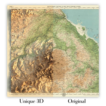
For something truly unique, this map is also available in "Unique 3D", our trademarked process that dramatically transforms the map so that it has a wonderful sense of depth. We combine the original map with detailed topography and elevation data, so that mountains and the terrain really "pop". For more info and examples of 3D maps, check my Unique 3D page.
Many of our maps and art prints are chosen as thoughtful gifts for homes, offices, studies and meaningful places.
Choose a framed option for the easiest ready-to-hang gift, or choose an unframed print if the recipient may prefer to select their own frame.
We make orders locally in 23 countries around the world, so gifts can often be produced close to the recipient. This helps them arrive faster, travel more safely, and avoid customs or import duty surprises.
- We can deliver directly to the recipient
- Framed pieces arrive ready to hang
- Unframed prints are carefully packed in a strong protective tube
- Almost every order is made locally, for faster, safer gifting
- 90-day returns give the recipient time to decide
If you are not sure what to choose, please contact us. We can help you pick the right map, size, finish or delivery option.
Para la mayoría de los pedidos, el tiempo de entrega es de aproximadamente 3 días laborables. Los productos personalizados y a medida tardan más, ya que tengo que hacer la personalización y enviártelo para su aprobación, lo cual suele tardar 1 o 2 días.
Tenga en cuenta que los pedidos enmarcados muy grandes suelen tardar más en fabricarse y entregarse.
Si necesitas que tu pedido llegue para una fecha determinada, por favor contáctame antes de hacer el pedido para que podamos encontrar la mejor manera de asegurarnos de que recibas tu pedido a tiempo.
Imprimo y enmarco mapas y obras de arte en 23 países alrededor del mundo. Esto significa que tu pedido se fabricará localmente, lo que reduce el tiempo de entrega y asegura que no se dañe durante el envío. Nunca pagarás aranceles de aduana o impuestos de importación, y pondremos menos CO2 en el aire.
Todos mis mapas y impresiones artísticas están bien empaquetados y enviados en un tubo resistente si no están enmarcados, o rodeados de espuma si están enmarcados.
Intento enviar todos los pedidos dentro de 1 o 2 días después de recibir tu pedido, aunque algunos productos (como mascarillas, tazas y bolsas de tela) pueden tardar más en fabricarse.
Si seleccionas Entrega Exprés al finalizar la compra, priorizaremos tu pedido y lo enviaremos por mensajería de 1 día (Fedex, DHL, UPS, Parcelforce).
La entrega al día siguiente también está disponible en algunos países (EE. UU., Reino Unido, Singapur, EAU), pero por favor intenta hacer tu pedido temprano en el día para que podamos enviarlo a tiempo.
Mi marco estándar es un marco de madera de fresno negro estilo galería. Es simple y tiene un aspecto bastante moderno. Mi marco estándar tiene alrededor de 20 mm (0.8 in) de ancho.
Utilizo acrílico super claro (perspex/acrylite) para el vidrio del marco. Es más ligero y seguro que el vidrio, y se ve mejor, ya que la reflectividad es menor.
Seis colores de marco estándar están disponibles de forma gratuita (negro, marrón oscuro, gris oscuro, roble, blanco y oro antiguo).El enmarcado y montaje/matizado personalizado está disponible si buscas algo diferente.
La mayoría de los mapas, arte e ilustraciones también están disponibles como un lienzo enmarcado. Utilizamos lienzo de algodón mate (no brillante), lo estiramos sobre un marco de madera de caja de origen sostenible, y luego 'flotamos' la pieza dentro de un marco de madera. El resultado final es bastante hermoso, y no hay cristal que se interponga.
Todos los marcos se proporcionan "listos para colgar", con una cuerda o soportes en la parte posterior. Los marcos muy grandes tendrán placas de colgar de alta resistencia y/o un listón de montaje. Si tienes alguna pregunta, por favor ponte en contacto.
Mira algunos ejemplos de mis mapas enmarcados y mapas en lienzo enmarcados.
Alternativamente, también puedo proporcionar mapas antiguos y obras de arte en lienzo, tablero de espuma, papel de algodón y otros materiales.
Si deseas enmarcar tu mapa o obra de arte tú mismo, por favor lee mi guía de tamaños primero.
Mis mapas son reproducciones de mapas originales de altísima calidad.
Obtengo mapas originales y raros de bibliotecas, casas de subastas y colecciones privadas de todo el mundo, los restauro en mi taller de Londres y luego uso tintas e impresoras giclée especializadas para crear hermosos mapas que lucen incluso mejor que el original.
Mis mapas están impresos en papel de archivo mate (no brillante) sin ácido que se siente de muy alta calidad y casi como una tarjeta. En términos técnicos, el peso/grosor del papel es de 10 mil/200 g/m². Es perfecto para enmarcar.
Imprimo con tintas pigmentadas Epson ultrachrome giclée UV resistentes a la decoloración, algunas de las mejores tintas que puedes encontrar.
yo también puedo hacer mapas sobre lienzo, trapo de algodón y otros materiales exóticos.
Obtenga más información sobre The Unique Maps Co..
Personalización de mapas
Si está buscando el regalo perfecto de aniversario o inauguración de la casa, puedo personalizar su mapa para hacerlo verdaderamente único. Por ejemplo, puedo agregar un mensaje corto, resaltar una ubicación importante o agregar el escudo de armas de su familia.
Las opciones son casi infinitas. Por favor mira mi página de personalización de mapas para ver algunos maravillosos ejemplos de lo que es posible.
Para pedir un mapa personalizado, seleccione "personalizar su mapa" antes de agregarlo a su carrito.
Ponerse en contacto si buscas personalizaciones y personalizaciones más complejas.
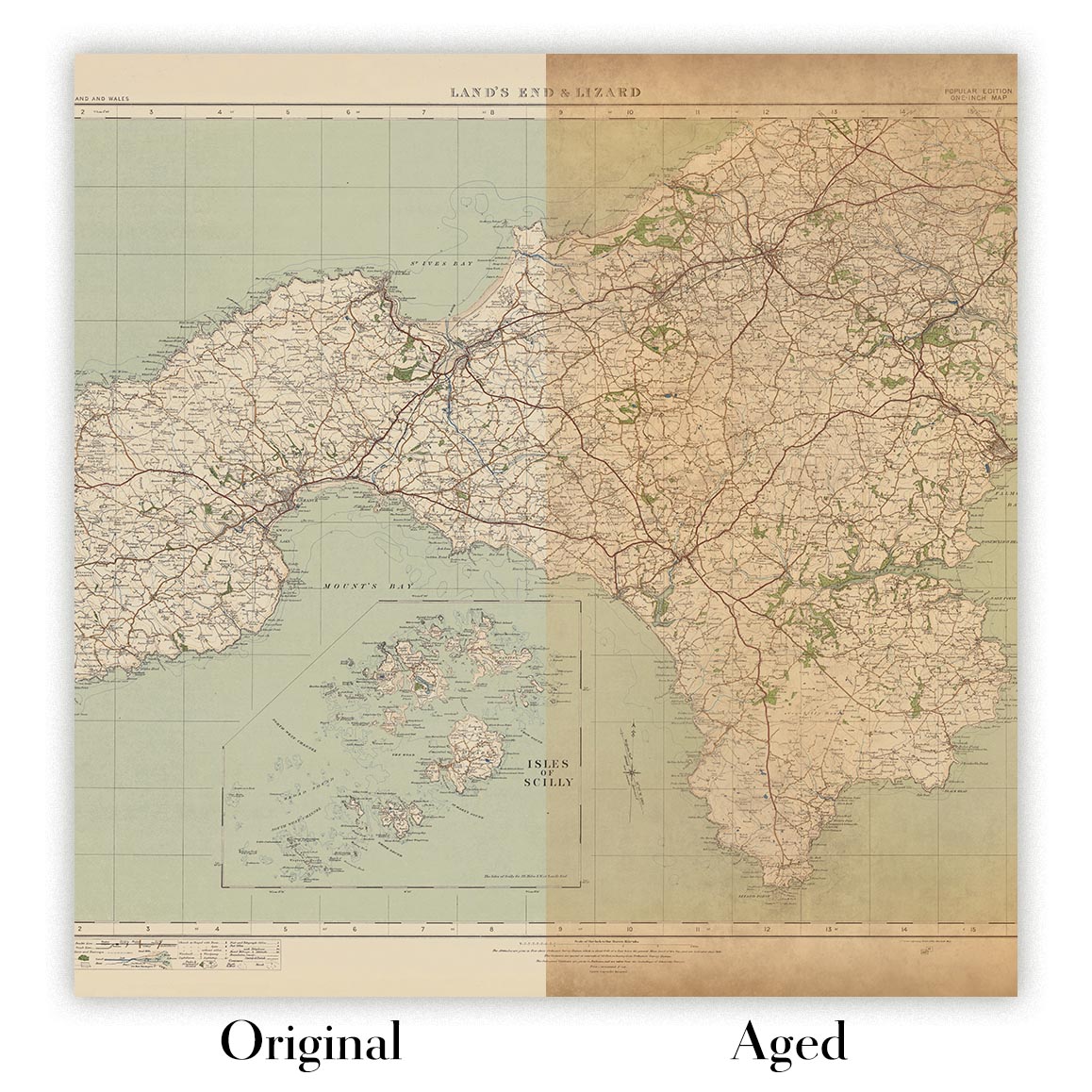
Envejecimiento del mapa
A lo largo de los años, los clientes me han preguntado cientos de veces si podían comprar un mapa que se viera uniforme. más viejo.
Bueno, ahora puedes hacerlo seleccionando Envejecido antes de agregar un mapa a tu carrito.
Todas las fotografías de productos que ve en esta página muestran el mapa en su forma original. Así es como se ve el mapa hoy.
Si selecciona Envejecido, envejeceré su mapa a mano, usando un proceso especial y único desarrollado a través de años de estudiar mapas antiguos, hablar con investigadores para comprender la química del envejecimiento del papel y, por supuesto... ¡mucha práctica!
Si no estás seguro, quédate con el color original del mapa. Si quieres algo un poco más oscuro y más viejo buscando, opte por Envejecido.
Si no estás satisfecho con tu pedido por cualquier motivo, contáctame para un reembolso sin complicaciones. Por favor, consulta nuestra política de devoluciones y reembolsos para más información.
Estoy muy seguro de que te gustará tu mapa o impresión artística restaurada. He estado haciendo esto desde 1984. Soy un vendedor de 5 estrellas en Etsy. He vendido decenas de miles de mapas e impresiones artísticas y tengo más de 5,000 opiniones reales de 5 estrellas.
Utilizo un proceso único para restaurar mapas y obras de arte que consume mucho tiempo y mano de obra. Buscar los mapas e ilustraciones originales puede llevar meses. Utilizo tecnología de última generación y extremadamente cara para escanear y restaurarlos. Como resultado, garantizo que mis mapas e impresiones artísticas son superiores a los demás - por eso puedo ofrecer un reembolso sin complicaciones.
Casi todos mis mapas e impresiones artísticas se ven increíbles en tamaños grandes (200cm, 6.5ft+) y también puedo enmarcarlos y entregártelos a través de un servicio de mensajería especial para tamaños grandes. Contáctame para discutir tus necesidades específicas.
Or try searching for something!


