


Antiguo mapa cordiforme doble del mundo magallánico de Oronce Fine, 1531: el mar de Magallanes, Terra Australis
La oferta del coleccionista
Elija dos obras elegibles y obtenga un 20 % de descuento en ambas. Elija tres y la de menor precio será gratuita, con un ahorro máximo del 33 %.
Combine y mezcle mapas estándar elegibles y reproducciones de bellas artes. No se requiere código; la oferta se aplica automáticamente al finalizar la compra.
Se incluyen las configuraciones estándar hechas por encargo. Quedan excluidos los tamaños a medida, los diseños personalizados y los trabajos por encargo.
¿Necesita entrega en diferentes direcciones? Contáctenos antes de realizar el pedido.La oferta del coleccionista
Elija dos obras elegibles y obtenga un 20 % de descuento en ambas. Elija tres y la de menor precio será gratuita, con un ahorro máximo del 33 %.
Combine y mezcle mapas estándar elegibles y reproducciones de bellas artes. No se requiere código; la oferta se aplica automáticamente al finalizar la compra.
Se incluyen las configuraciones estándar hechas por encargo. Quedan excluidos los tamaños a medida, los diseños personalizados y los trabajos por encargo.
¿Necesita entrega en diferentes direcciones? Contáctenos antes de realizar el pedido.
Restaurado a partir del mapa original de 1531 e impreso en calidad museo. Leer la historia detrás de este mapa
Choose your size
Choose your finish


(Más información)
Mensaje de regalo y acabado personalizado

Si deseas agregar un mensaje de regalo, o un acabado (rompecabezas, tablero de aluminio, etc.) que no esté disponible aquí, por favor solicítalo en la "nota del pedido" cuando realices la compra.
Cada pedido es hecho a medida, así que si necesitas que el tamaño se ajuste ligeramente, o que se imprima en un material inusual, háznoslo saber. Hemos realizado miles de pedidos personalizados a lo largo de los años, así que hay (casi) nada que no podamos gestionar.
También puedes contactarnos antes de hacer tu pedido, ¡si lo prefieres!

- Hecho localmente. Entrega segura
- Sin aranceles ni cargos ocultos
- ¿Necesitas ayuda? Llámanos o mensaje por WhatsApp
Own a piece of history
8,000+ five-star reviews


Adéntrese en el fascinante mundo de la cartografía renacentista con la “Nova, et Integra Universi Orbis Descriptio” de Oronce Fine, una obra...
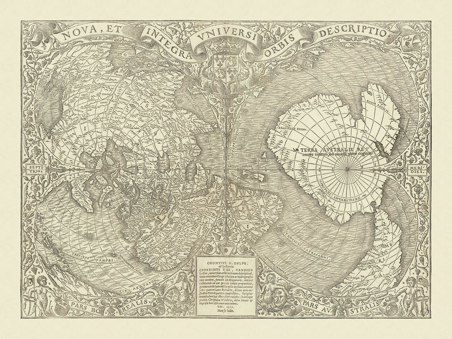
Seguir leyendoAdéntrese en el fascinante mundo de la cartografía renacentista con la “Nova, et Integra Universi Orbis Descriptio” de Oronce Fine, una obra maestra publicada por primera vez en 1531. Este extraordinario mapa, la primera proyección cordiforme doble (en forma de corazón) conocida del mundo, se erige como testimonio tanto de la ambición como del arte de los primeros cartógrafos modernos. Fine, eminente matemático y geógrafo francés, sintetizó de manera ingeniosa los descubrimientos más recientes de su época —en particular los viajes de Magallanes y Cortés— en una visión del globo que era a la vez científicamente avanzada y visualmente cautivadora. El título latino original del mapa, que se traduce como “Una nueva y completa descripción de todo el mundo”, encapsula a la perfección su alcance innovador y el espíritu de exploración que definió la época.
Creado en una época en que las fronteras del mundo conocido se expandían rápidamente, el mapa de Fine captura la emoción y la incertidumbre de principios del siglo XVI. Es uno de los primeros mapas en mencionar el “Mare magellanicum”, en honor a la circunnavegación histórica de Fernando de Magallanes. El mapa delimita con audacia la misteriosa Terra Australis —“recientemente descubierta pero aún no explorada”—, un vasto continente austral que durante siglos avivaría la curiosidad de exploradores y geógrafos. América Central aparece profusamente anotada con topónimos que reflejan las conquistas y exploraciones de Cortés, mientras que el continente norteamericano se representa de forma intrigante como una extensión de Asia, revelando la comprensión europea en evolución de la geografía mundial.
La proyección cordiforme doble del mapa es una maravilla de ingenio geométrico, que reduce la Tierra esférica a dos lóbulos con forma de corazón elegantemente entrelazados. Este formato singular, ideado por el propio Fine, se convertiría en un modelo para los mapas del mundo durante décadas, precediendo al auge de las proyecciones ovaladas y de doble hemisferio, y la eventual hegemonía de la proyección de Mercator. La proyección no solo constituye un logro técnico, sino que también confiere al mapa una sensación de armonía y unidad, invitando al espectador a contemplar la interconexión de los continentes y océanos del mundo.
Desde el punto de vista estético, el mapa de Fine es una obra cumbre del arte renacentista. El detallado grabado en madera está enmarcado por un exuberante borde floral, flanqueado por dos sirenas y querubines musculosos que evocan lo mítico y lo marítimo. El escudo real francés se exhibe con orgullo, mientras que una cinta ondulante en la parte superior proclama el título del mapa. La cartela inferior lleva el nombre de Fine, marcando esta pieza como el codiciado primer estado del mapa, un rasgo raro y deseable para coleccionistas y conocedores. Cada elemento, desde el ornamento del borde hasta las masas terrestres minuciosamente grabadas, refleja los ideales humanistas y la sensibilidad decorativa de su tiempo.
Dentro de su intrincado diseño, el mapa revela un mundo a la vez familiar y fantástico. Groenlandia se muestra como una isla separada, mientras que el Ártico se representa como cuatro islas enigmáticas. El promontorio etiquetado como “Gaccalar” —que se cree que representa Labrador— se proyecta audazmente hacia el Atlántico. Las cordilleras, los ríos y las costas se trazan con un detalle que habla de la dedicación de Fine a la precisión, aun cuando los límites del conocimiento contemporáneo dejaban vastas regiones envueltas en misterio. Este mapa no es solo un registro del mundo tal como se conocía en 1531; es una celebración del descubrimiento, la imaginación y la búsqueda perdurable de cartografiar lo desconocido.
Countries and regions on this map
- Europe
- Asia
- Africa
- America (North and South America, with North America depicted as part of Asia)
- Terra Australis (continente austral, aún no explorado)
- Groenlandia
- Gaccalar (Labrador)
- América Central (con nombres de lugares específicos de la primera exploración española)
- Mare magellanicum (Mar de Magallanes, masa de agua)
- Región ártica (representada como cuatro islas)
Características y hitos destacados
- Proyección doble cordiforme (en forma de corazón), dividida en dos lóbulos
- Borde decorativo floral que rodea el mapa
- Dos sirenas ilustradas fuera del mapa
- Dos querubines musculosos (putti) representados fuera del mapa
- Escudo real francés exhibido de forma prominente
- Bandera ondulante con el título del mapa en la parte superior
- Cartela inferior con el nombre de Oronce Fine (Orontius F. Delph)
- Mare magellanicum (Mar de Magallanes) señalado más allá del extremo de Sudamérica
- Terra Australis ("descubierto recientemente pero aún no explorado") ocupa gran parte del lóbulo sur
- Cuatro islas representadas en el Polo Norte
- Isla independiente señalada como Groenlandia
- Gran promontorio señalado como Gaccalar (supuestamente Labrador) que se extiende desde América del Norte
- Numerosos nombres de lugares en América Central que reflejan la primera exploración española
- Detalles físicos como cordilleras y ríos
Contexto histórico y de diseño
- Primer mapa del mundo de doble proyección cordiforme (en forma de corazón) jamás producido
- Creado por Oronce Fine, eminente cartógrafo y matemático francés, en 1531
- Uno de los primeros mapas en mencionar a Magallanes (Mare magellanicum)
- Se convirtió en un modelo para los mapas del mundo durante varias décadas, antes del auge de las proyecciones ovales y de doble hemisferio, y de la proyección de Mercator
- Basado en sofisticados principios geométricos para representar la Tierra esférica en dos dimensiones
- Grabado en madera detallado con arte renacentista e ideales humanistas
- Apareció por primera vez en la edición parisina de 1532 de Novus orbis regionum de Johann Huttich y Simon Grynaeus
- La primera edición del mapa, la única que presenta el nombre de Oronce Fine en la cartela inferior
- Celebra el espíritu de exploración y descubrimiento durante principios del siglo XVI
Por favor, compruebe las imágenes para asegurarse de que una ciudad o lugar específico aparece en este mapa. También puede ponerse en contacto con nosotros y pedirnos que revisemos el mapa por usted.
Este mapa se ve estupendo en cualquier tamaño, pero siempre recomiendo optar por un tamaño mayor si dispone de espacio. De ese modo podrá apreciar fácilmente todos los detalles.
Este mapa se ve increíble en tamaños de hasta 70in (180cm). Si busca un mapa más grande, por favor póngase en contacto.
La modelo de las imágenes del anuncio sostiene la versión de 18x24in (45x60cm) de este mapa.
La quinta imagen del anuncio muestra un ejemplo de mi servicio de personalización de mapas.
Si busca algo ligeramente diferente, eche un vistazo a mi colección de los mejores mapas antiguos para ver si algo más le llama la atención.
Por favor contácteme para comprobar si una cierta ubicación, hito o característica aparece en este mapa.
Sería un regalo maravilloso de cumpleaños, Navidad, Día del Padre, despedida del trabajo, aniversario o inauguración de la casa para alguien de las zonas abarcadas por este mapa.
Este mapa está disponible como impresión giclée en papel mate de archivo sin ácido, o puede adquirirse enmarcado. El marco es un elegante y sencillo marco negro que se adapta a la mayoría de las estéticas. Póngase en contacto si desea un color o material de marco diferente. Mis marcos están acristalados con acrílico de grado museo supertransparente (perspex/acrylite), que es significativamente menos reflectante que el vidrio, más seguro y siempre llegará en perfectas condiciones.
This map is also available as a float framed canvas, sometimes known as a shadow gap framed canvas or canvas floater. The map is printed on artist's cotton canvas and then stretched over a handmade box frame. We then "float" the canvas inside a wooden frame, which is available in a range of colours (black, dark brown, oak, antique gold and white). This is a wonderful way to present a map without glazing in front. See some examples of float framed canvas maps and explore the differences between my different finishes.
For something truly unique, this map is also available in "Unique 3D", our trademarked process that dramatically transforms the map so that it has a wonderful sense of depth. We combine the original map with detailed topography and elevation data, so that mountains and the terrain really "pop". For more info and examples of 3D maps, check my Unique 3D page.
Adéntrese en el fascinante mundo de la cartografía renacentista con la “Nova, et Integra Universi Orbis Descriptio” de Oronce Fine, una obra maestra publicada por primera vez en 1531. Este extraordinario mapa, la primera proyección cordiforme doble (en forma de corazón) conocida del mundo, se erige como testimonio tanto de la ambición como del arte de los primeros cartógrafos modernos. Fine, eminente matemático y geógrafo francés, sintetizó de manera ingeniosa los descubrimientos más recientes de su época —en particular los viajes de Magallanes y Cortés— en una visión del globo que era a la vez científicamente avanzada y visualmente cautivadora. El título latino original del mapa, que se traduce como “Una nueva y completa descripción de todo el mundo”, encapsula a la perfección su alcance innovador y el espíritu de exploración que definió la época.
Creado en una época en que las fronteras del mundo conocido se expandían rápidamente, el mapa de Fine captura la emoción y la incertidumbre de principios del siglo XVI. Es uno de los primeros mapas en mencionar el “Mare magellanicum”, en honor a la circunnavegación histórica de Fernando de Magallanes. El mapa delimita con audacia la misteriosa Terra Australis —“recientemente descubierta pero aún no explorada”—, un vasto continente austral que durante siglos avivaría la curiosidad de exploradores y geógrafos. América Central aparece profusamente anotada con topónimos que reflejan las conquistas y exploraciones de Cortés, mientras que el continente norteamericano se representa de forma intrigante como una extensión de Asia, revelando la comprensión europea en evolución de la geografía mundial.
La proyección cordiforme doble del mapa es una maravilla de ingenio geométrico, que reduce la Tierra esférica a dos lóbulos con forma de corazón elegantemente entrelazados. Este formato singular, ideado por el propio Fine, se convertiría en un modelo para los mapas del mundo durante décadas, precediendo al auge de las proyecciones ovaladas y de doble hemisferio, y la eventual hegemonía de la proyección de Mercator. La proyección no solo constituye un logro técnico, sino que también confiere al mapa una sensación de armonía y unidad, invitando al espectador a contemplar la interconexión de los continentes y océanos del mundo.
Desde el punto de vista estético, el mapa de Fine es una obra cumbre del arte renacentista. El detallado grabado en madera está enmarcado por un exuberante borde floral, flanqueado por dos sirenas y querubines musculosos que evocan lo mítico y lo marítimo. El escudo real francés se exhibe con orgullo, mientras que una cinta ondulante en la parte superior proclama el título del mapa. La cartela inferior lleva el nombre de Fine, marcando esta pieza como el codiciado primer estado del mapa, un rasgo raro y deseable para coleccionistas y conocedores. Cada elemento, desde el ornamento del borde hasta las masas terrestres minuciosamente grabadas, refleja los ideales humanistas y la sensibilidad decorativa de su tiempo.
Dentro de su intrincado diseño, el mapa revela un mundo a la vez familiar y fantástico. Groenlandia se muestra como una isla separada, mientras que el Ártico se representa como cuatro islas enigmáticas. El promontorio etiquetado como “Gaccalar” —que se cree que representa Labrador— se proyecta audazmente hacia el Atlántico. Las cordilleras, los ríos y las costas se trazan con un detalle que habla de la dedicación de Fine a la precisión, aun cuando los límites del conocimiento contemporáneo dejaban vastas regiones envueltas en misterio. Este mapa no es solo un registro del mundo tal como se conocía en 1531; es una celebración del descubrimiento, la imaginación y la búsqueda perdurable de cartografiar lo desconocido.
Countries and regions on this map
- Europe
- Asia
- Africa
- America (North and South America, with North America depicted as part of Asia)
- Terra Australis (continente austral, aún no explorado)
- Groenlandia
- Gaccalar (Labrador)
- América Central (con nombres de lugares específicos de la primera exploración española)
- Mare magellanicum (Mar de Magallanes, masa de agua)
- Región ártica (representada como cuatro islas)
Características y hitos destacados
- Proyección doble cordiforme (en forma de corazón), dividida en dos lóbulos
- Borde decorativo floral que rodea el mapa
- Dos sirenas ilustradas fuera del mapa
- Dos querubines musculosos (putti) representados fuera del mapa
- Escudo real francés exhibido de forma prominente
- Bandera ondulante con el título del mapa en la parte superior
- Cartela inferior con el nombre de Oronce Fine (Orontius F. Delph)
- Mare magellanicum (Mar de Magallanes) señalado más allá del extremo de Sudamérica
- Terra Australis ("descubierto recientemente pero aún no explorado") ocupa gran parte del lóbulo sur
- Cuatro islas representadas en el Polo Norte
- Isla independiente señalada como Groenlandia
- Gran promontorio señalado como Gaccalar (supuestamente Labrador) que se extiende desde América del Norte
- Numerosos nombres de lugares en América Central que reflejan la primera exploración española
- Detalles físicos como cordilleras y ríos
Contexto histórico y de diseño
- Primer mapa del mundo de doble proyección cordiforme (en forma de corazón) jamás producido
- Creado por Oronce Fine, eminente cartógrafo y matemático francés, en 1531
- Uno de los primeros mapas en mencionar a Magallanes (Mare magellanicum)
- Se convirtió en un modelo para los mapas del mundo durante varias décadas, antes del auge de las proyecciones ovales y de doble hemisferio, y de la proyección de Mercator
- Basado en sofisticados principios geométricos para representar la Tierra esférica en dos dimensiones
- Grabado en madera detallado con arte renacentista e ideales humanistas
- Apareció por primera vez en la edición parisina de 1532 de Novus orbis regionum de Johann Huttich y Simon Grynaeus
- La primera edición del mapa, la única que presenta el nombre de Oronce Fine en la cartela inferior
- Celebra el espíritu de exploración y descubrimiento durante principios del siglo XVI
Por favor, compruebe las imágenes para asegurarse de que una ciudad o lugar específico aparece en este mapa. También puede ponerse en contacto con nosotros y pedirnos que revisemos el mapa por usted.
Este mapa se ve estupendo en cualquier tamaño, pero siempre recomiendo optar por un tamaño mayor si dispone de espacio. De ese modo podrá apreciar fácilmente todos los detalles.
Este mapa se ve increíble en tamaños de hasta 70in (180cm). Si busca un mapa más grande, por favor póngase en contacto.
La modelo de las imágenes del anuncio sostiene la versión de 18x24in (45x60cm) de este mapa.
La quinta imagen del anuncio muestra un ejemplo de mi servicio de personalización de mapas.
Si busca algo ligeramente diferente, eche un vistazo a mi colección de los mejores mapas antiguos para ver si algo más le llama la atención.
Por favor contácteme para comprobar si una cierta ubicación, hito o característica aparece en este mapa.
Sería un regalo maravilloso de cumpleaños, Navidad, Día del Padre, despedida del trabajo, aniversario o inauguración de la casa para alguien de las zonas abarcadas por este mapa.
Este mapa está disponible como impresión giclée en papel mate de archivo sin ácido, o puede adquirirse enmarcado. El marco es un elegante y sencillo marco negro que se adapta a la mayoría de las estéticas. Póngase en contacto si desea un color o material de marco diferente. Mis marcos están acristalados con acrílico de grado museo supertransparente (perspex/acrylite), que es significativamente menos reflectante que el vidrio, más seguro y siempre llegará en perfectas condiciones.
This map is also available as a float framed canvas, sometimes known as a shadow gap framed canvas or canvas floater. The map is printed on artist's cotton canvas and then stretched over a handmade box frame. We then "float" the canvas inside a wooden frame, which is available in a range of colours (black, dark brown, oak, antique gold and white). This is a wonderful way to present a map without glazing in front. See some examples of float framed canvas maps and explore the differences between my different finishes.
For something truly unique, this map is also available in "Unique 3D", our trademarked process that dramatically transforms the map so that it has a wonderful sense of depth. We combine the original map with detailed topography and elevation data, so that mountains and the terrain really "pop". For more info and examples of 3D maps, check my Unique 3D page.
Many of our maps and art prints are chosen as thoughtful gifts for homes, offices, studies and meaningful places.
Choose a framed option for the easiest ready-to-hang gift, or choose an unframed print if the recipient may prefer to select their own frame.
We make orders locally in 23 countries around the world, so gifts can often be produced close to the recipient. This helps them arrive faster, travel more safely, and avoid customs or import duty surprises.
- We can deliver directly to the recipient
- Framed pieces arrive ready to hang
- Unframed prints are carefully packed in a strong protective tube
- Almost every order is made locally, for faster, safer gifting
- 90-day returns give the recipient time to decide
If you are not sure what to choose, please contact us. We can help you pick the right map, size, finish or delivery option.
Para la mayoría de los pedidos, el tiempo de entrega es de aproximadamente 3 días laborables. Los productos personalizados y a medida tardan más, ya que tengo que hacer la personalización y enviártelo para su aprobación, lo cual suele tardar 1 o 2 días.
Tenga en cuenta que los pedidos enmarcados muy grandes suelen tardar más en fabricarse y entregarse.
Si necesitas que tu pedido llegue para una fecha determinada, por favor contáctame antes de hacer el pedido para que podamos encontrar la mejor manera de asegurarnos de que recibas tu pedido a tiempo.
Imprimo y enmarco mapas y obras de arte en 23 países alrededor del mundo. Esto significa que tu pedido se fabricará localmente, lo que reduce el tiempo de entrega y asegura que no se dañe durante el envío. Nunca pagarás aranceles de aduana o impuestos de importación, y pondremos menos CO2 en el aire.
Todos mis mapas y impresiones artísticas están bien empaquetados y enviados en un tubo resistente si no están enmarcados, o rodeados de espuma si están enmarcados.
Intento enviar todos los pedidos dentro de 1 o 2 días después de recibir tu pedido, aunque algunos productos (como mascarillas, tazas y bolsas de tela) pueden tardar más en fabricarse.
Si seleccionas Entrega Exprés al finalizar la compra, priorizaremos tu pedido y lo enviaremos por mensajería de 1 día (Fedex, DHL, UPS, Parcelforce).
La entrega al día siguiente también está disponible en algunos países (EE. UU., Reino Unido, Singapur, EAU), pero por favor intenta hacer tu pedido temprano en el día para que podamos enviarlo a tiempo.
Mi marco estándar es un marco de madera de fresno negro estilo galería. Es simple y tiene un aspecto bastante moderno. Mi marco estándar tiene alrededor de 20 mm (0.8 in) de ancho.
Utilizo acrílico super claro (perspex/acrylite) para el vidrio del marco. Es más ligero y seguro que el vidrio, y se ve mejor, ya que la reflectividad es menor.
Seis colores de marco estándar están disponibles de forma gratuita (negro, marrón oscuro, gris oscuro, roble, blanco y oro antiguo).El enmarcado y montaje/matizado personalizado está disponible si buscas algo diferente.
La mayoría de los mapas, arte e ilustraciones también están disponibles como un lienzo enmarcado. Utilizamos lienzo de algodón mate (no brillante), lo estiramos sobre un marco de madera de caja de origen sostenible, y luego 'flotamos' la pieza dentro de un marco de madera. El resultado final es bastante hermoso, y no hay cristal que se interponga.
Todos los marcos se proporcionan "listos para colgar", con una cuerda o soportes en la parte posterior. Los marcos muy grandes tendrán placas de colgar de alta resistencia y/o un listón de montaje. Si tienes alguna pregunta, por favor ponte en contacto.
Mira algunos ejemplos de mis mapas enmarcados y mapas en lienzo enmarcados.
Alternativamente, también puedo proporcionar mapas antiguos y obras de arte en lienzo, tablero de espuma, papel de algodón y otros materiales.
Si deseas enmarcar tu mapa o obra de arte tú mismo, por favor lee mi guía de tamaños primero.
Mis mapas son reproducciones de mapas originales de altísima calidad.
Obtengo mapas originales y raros de bibliotecas, casas de subastas y colecciones privadas de todo el mundo, los restauro en mi taller de Londres y luego uso tintas e impresoras giclée especializadas para crear hermosos mapas que lucen incluso mejor que el original.
Mis mapas están impresos en papel de archivo mate (no brillante) sin ácido que se siente de muy alta calidad y casi como una tarjeta. En términos técnicos, el peso/grosor del papel es de 10 mil/200 g/m². Es perfecto para enmarcar.
Imprimo con tintas pigmentadas Epson ultrachrome giclée UV resistentes a la decoloración, algunas de las mejores tintas que puedes encontrar.
yo también puedo hacer mapas sobre lienzo, trapo de algodón y otros materiales exóticos.
Obtenga más información sobre The Unique Maps Co..
Personalización de mapas
Si está buscando el regalo perfecto de aniversario o inauguración de la casa, puedo personalizar su mapa para hacerlo verdaderamente único. Por ejemplo, puedo agregar un mensaje corto, resaltar una ubicación importante o agregar el escudo de armas de su familia.
Las opciones son casi infinitas. Por favor mira mi página de personalización de mapas para ver algunos maravillosos ejemplos de lo que es posible.
Para pedir un mapa personalizado, seleccione "personalizar su mapa" antes de agregarlo a su carrito.
Ponerse en contacto si buscas personalizaciones y personalizaciones más complejas.
Envejecimiento del mapa
A lo largo de los años, los clientes me han preguntado cientos de veces si podían comprar un mapa que se viera uniforme. más viejo.
Bueno, ahora puedes hacerlo seleccionando Envejecido antes de agregar un mapa a tu carrito.
Todas las fotografías de productos que ve en esta página muestran el mapa en su forma original. Así es como se ve el mapa hoy.
Si selecciona Envejecido, envejeceré su mapa a mano, usando un proceso especial y único desarrollado a través de años de estudiar mapas antiguos, hablar con investigadores para comprender la química del envejecimiento del papel y, por supuesto... ¡mucha práctica!
Si no estás seguro, quédate con el color original del mapa. Si quieres algo un poco más oscuro y más viejo buscando, opte por Envejecido.
Si no estás satisfecho con tu pedido por cualquier motivo, contáctame para un reembolso sin complicaciones. Por favor, consulta nuestra política de devoluciones y reembolsos para más información.
Estoy muy seguro de que te gustará tu mapa o impresión artística restaurada. He estado haciendo esto desde 1984. Soy un vendedor de 5 estrellas en Etsy. He vendido decenas de miles de mapas e impresiones artísticas y tengo más de 5,000 opiniones reales de 5 estrellas.
Utilizo un proceso único para restaurar mapas y obras de arte que consume mucho tiempo y mano de obra. Buscar los mapas e ilustraciones originales puede llevar meses. Utilizo tecnología de última generación y extremadamente cara para escanear y restaurarlos. Como resultado, garantizo que mis mapas e impresiones artísticas son superiores a los demás - por eso puedo ofrecer un reembolso sin complicaciones.
Casi todos mis mapas e impresiones artísticas se ven increíbles en tamaños grandes (200cm, 6.5ft+) y también puedo enmarcarlos y entregártelos a través de un servicio de mensajería especial para tamaños grandes. Contáctame para discutir tus necesidades específicas.
Or try searching for something!


