

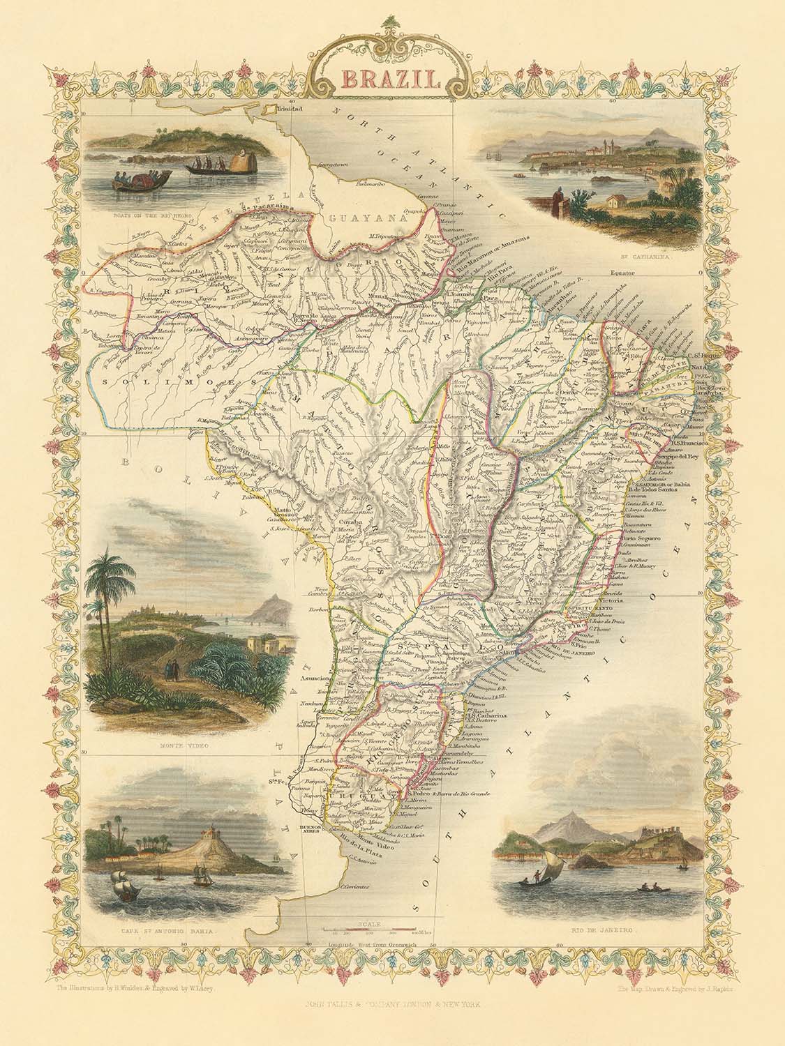


Antiguo mapa de Brasil de Tallis, 1851: río Amazonas, Río de Janeiro, São Paulo, Salvador, costa atlántica
20% de descuento en 2 — 33% de descuento en 3
Añade dos artículos elegibles a tu carrito para recibir 20% de descuento. Añade un tercero y será complementario (equivalente a 33% de descuento al comprar tres).
No se necesita código — la oferta se aplica automáticamente al finalizar la compra.
Válido en todos los mapas estándar y impresiones de arte fino. Puedes mezclar y combinar cualquier diseño.
Si deseas enviar artículos a múltiples direcciones, por favor contáctanos antes de realizar tu pedido.
Las comisiones personalizadas y a medida están excluidas.
Contáctanos si tienes alguna pregunta

Restaurado a partir del mapa original de 1851 e impreso en calidad museo. Leer la historia detrás de este mapa
Choose your size
Choose your finish


(Más información)
Mensaje de regalo y acabado personalizado

Si deseas agregar un mensaje de regalo, o un acabado (rompecabezas, tablero de aluminio, etc.) que no esté disponible aquí, por favor solicítalo en la "nota del pedido" cuando realices la compra.
Cada pedido es hecho a medida, así que si necesitas que el tamaño se ajuste ligeramente, o que se imprima en un material inusual, háznoslo saber. Hemos realizado miles de pedidos personalizados a lo largo de los años, así que hay (casi) nada que no podamos gestionar.
También puedes contactarnos antes de hacer tu pedido, ¡si lo prefieres!

- Hecho localmente. Entrega segura
- Sin aranceles ni cargos ocultos
- ¿Necesitas ayuda? Llámanos o mensaje por WhatsApp
Own a piece of history
8,000+ five-star reviews


Adéntrese en la grandiosidad de la cartografía del siglo XIX con "Brazil," el mapa original de 1851 del célebre cartógrafo británico John...
Seguir leyendoAdéntrese en la grandiosidad de la cartografía del siglo XIX con "Brazil," el mapa original de 1851 del célebre cartógrafo británico John Tallis. Esta exquisita pieza captura Brasil en un momento crucial de su historia, durante la era del Imperio de Brasil. El título del mapa, inscrito con elegancia, denota una dedicación tanto a la precisión como al arte, señas distintivas de la reconocida obra de Tallis. Cada frontera provincial está meticulosamente delineada, ofreciendo una rara visión del panorama político de Brasil tal como era hace casi dos siglos.
John Tallis era famoso por su capacidad para combinar precisión científica con adornos decorativos, y este mapa no es una excepción. Bordes ornamentales enmarcan la composición, mientras que finas viñetas grabadas evocan los exuberantes paisajes y la vibrante cultura de Brasil. El arte no es meramente decorativo: sirve para sumergir al observador en el mundo de 1851, cuando la curiosidad europea por Sudamérica estaba en su apogeo y mapas como este eran posesiones muy apreciadas tanto por eruditos como por exploradores.
El mapa es un verdadero tapiz de las maravillas naturales de Brasil. El poderoso río Amazonas y sus extensos afluentes serpentean por la amplitud septentrional, mientras que las cordilleras y el terreno ondulado están representados con la maestría de un grabador. El océano Atlántico, claramente rotulado, bordea la costa oriental, subrayando las conexiones marítimas de Brasil y la importancia de sus ciudades portuarias. Cada río, montaña y contorno costero es testimonio de la dedicación de Tallis al detalle y de su profundo respeto por las maravillas geográficas del Nuevo Mundo.
Más allá de sus rasgos físicos, el mapa es una ventana a los centros urbanos que desde entonces han crecido hasta convertirse en algunas de las ciudades más dinámicas del mundo. Desde Río de Janeiro y São Paulo hasta Salvador, Recife y Belém, el mapa traza las primeras huellas de estos asentamientos. Cada ciudad aparece como un nodo de comercio, cultura y ambición colonial, insinuando las historias de migración, comercio y transformación que darían forma al Brasil moderno. La inclusión de poblaciones menos conocidas y capitales provinciales enriquece aún más la narrativa histórica, invitando al observador a seguir la evolución del paisaje urbano de Brasil.
Históricamente, este mapa ocupa un lugar singular como producto tanto del arte como de la curiosidad imperial. Creado durante un periodo de exploración global y competencia colonial, refleja no solo la geografía de Brasil, sino también las ambiciones y las imaginaciones de sus observadores europeos. Para coleccionistas, historiadores y amantes de la cartografía fina, "Brazil" de John Tallis es más que un mapa: es un artefacto de descubrimiento, una celebración de la belleza natural y un documento de una nación al borde de la transformación.
Ciudades y localidades en este mapa
- Rio de Janeiro
- São Paulo
- Salvador (Bahia)
- Recife (Pernambuco)
- Belém (Pará)
- São Luís (Maranhão)
- Fortaleza (Ceará)
- Cuiabá (Mato Grosso)
- Porto Alegre (Rio Grande do Sul)
- Natal (Rio Grande do Norte)
- João Pessoa (Paraíba)
- Maceió (Alagoas)
- Vitória (Espírito Santo)
Características destacadas y puntos de interés
- Borde decorativo y grabados ornamentales típicos de los mapas de John Tallis
- Ilustraciones que representan escenas brasileñas, incluidos pueblos indígenas, fauna local y vistas del paisaje
- Fronteras provinciales claramente marcadas dentro de Brasil
- Principales ríos, destacando de forma prominente el río Amazonas y sus afluentes
- Cordilleras y rasgos del relieve claramente ilustrados
- El océano Atlántico claramente señalado a lo largo de la costa oriental de Brasil
- Ríos menores y elementos costeros cuidadosamente detallados
Contexto histórico y de diseño
- Creado en 1851 por John Tallis, un reconocido cartógrafo y editor británico
- Título original: "Brazil"
- Ilustra tanto los rasgos políticos como físicos de Brasil, incluidas las fronteras regionales, los ríos, las montañas y las zonas costeras
- Estilo decorativo con bordes ornamentales, ilustraciones detalladas y grabado minucioso
- Producido durante la época del Imperio del Brasil (1822–1889), reflejando el panorama político de la época
- Ofrece contexto histórico sobre las divisiones territoriales y administrativas de Brasil a mediados del siglo XIX
- Un testimonio de la curiosidad y la exploración europeas de Sudamérica durante el siglo XIX
Por favor, revise las imágenes para asegurarse de que en este mapa aparece una ciudad o lugar concreto. También puede ponerse en contacto con nosotros y pedirnos que comprobemos el mapa por usted.
Este mapa luce magnífico en cualquier tamaño, pero siempre recomiendo optar por un tamaño mayor si dispone de espacio. Así podrá distinguir fácilmente todos los detalles.
Este mapa luce increíble en tamaños de hasta 50in (125cm). Si busca un mapa más grande, por favor póngase en contacto.
El modelo de las imágenes del anuncio sostiene la versión de 18x24in (45x60cm) de este mapa.
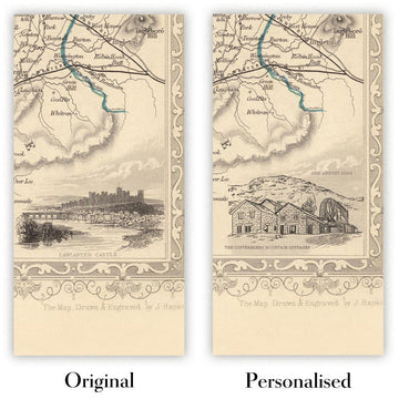
La quinta imagen del anuncio muestra un ejemplo de mi servicio de personalización de mapas.
Si busca algo un poco diferente, eche un vistazo a mi colección de los mejores mapas antiguos para ver si algo más le llama la atención.
Por favor, contácteme para comprobar si una determinada ubicación, hito o elemento aparece en este mapa.
Sería un regalo maravilloso de cumpleaños, Navidad, Día del Padre, despedida del trabajo, aniversario o inauguración de casa para alguien de las zonas cubiertas por este mapa.
Este mapa está disponible como impresión giclée en papel mate de archivo libre de ácido, o puede adquirirse enmarcado. El marco es un elegante y sencillo marco negro que combina con la mayoría de estéticas. Por favor, póngase en contacto si desea un color o material de marco diferente. Mis marcos están acristalados con acrílico de calidad museística ultratransparente (perspex/acrylite), que es significativamente menos reflectante que el vidrio, más seguro y siempre llegará en perfectas condiciones.
This map is also available as a float framed canvas, sometimes known as a shadow gap framed canvas or canvas floater. The map is printed on artist's cotton canvas and then stretched over a handmade box frame. We then "float" the canvas inside a wooden frame, which is available in a range of colours (black, dark brown, oak, antique gold and white). This is a wonderful way to present a map without glazing in front. See some examples of float framed canvas maps and explore the differences between my different finishes.
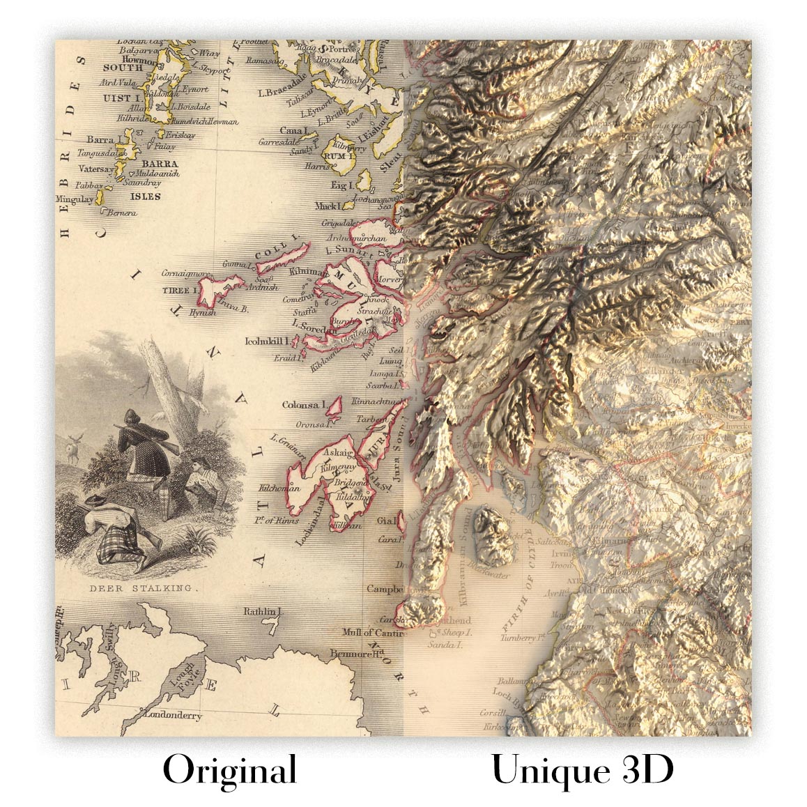
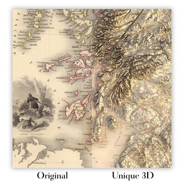
For something truly unique, this map is also available in "Unique 3D", our trademarked process that dramatically transforms the map so that it has a wonderful sense of depth. We combine the original map with detailed topography and elevation data, so that mountains and the terrain really "pop". For more info and examples of 3D maps, check my Unique 3D page.
Adéntrese en la grandiosidad de la cartografía del siglo XIX con "Brazil," el mapa original de 1851 del célebre cartógrafo británico John Tallis. Esta exquisita pieza captura Brasil en un momento crucial de su historia, durante la era del Imperio de Brasil. El título del mapa, inscrito con elegancia, denota una dedicación tanto a la precisión como al arte, señas distintivas de la reconocida obra de Tallis. Cada frontera provincial está meticulosamente delineada, ofreciendo una rara visión del panorama político de Brasil tal como era hace casi dos siglos.
John Tallis era famoso por su capacidad para combinar precisión científica con adornos decorativos, y este mapa no es una excepción. Bordes ornamentales enmarcan la composición, mientras que finas viñetas grabadas evocan los exuberantes paisajes y la vibrante cultura de Brasil. El arte no es meramente decorativo: sirve para sumergir al observador en el mundo de 1851, cuando la curiosidad europea por Sudamérica estaba en su apogeo y mapas como este eran posesiones muy apreciadas tanto por eruditos como por exploradores.
El mapa es un verdadero tapiz de las maravillas naturales de Brasil. El poderoso río Amazonas y sus extensos afluentes serpentean por la amplitud septentrional, mientras que las cordilleras y el terreno ondulado están representados con la maestría de un grabador. El océano Atlántico, claramente rotulado, bordea la costa oriental, subrayando las conexiones marítimas de Brasil y la importancia de sus ciudades portuarias. Cada río, montaña y contorno costero es testimonio de la dedicación de Tallis al detalle y de su profundo respeto por las maravillas geográficas del Nuevo Mundo.
Más allá de sus rasgos físicos, el mapa es una ventana a los centros urbanos que desde entonces han crecido hasta convertirse en algunas de las ciudades más dinámicas del mundo. Desde Río de Janeiro y São Paulo hasta Salvador, Recife y Belém, el mapa traza las primeras huellas de estos asentamientos. Cada ciudad aparece como un nodo de comercio, cultura y ambición colonial, insinuando las historias de migración, comercio y transformación que darían forma al Brasil moderno. La inclusión de poblaciones menos conocidas y capitales provinciales enriquece aún más la narrativa histórica, invitando al observador a seguir la evolución del paisaje urbano de Brasil.
Históricamente, este mapa ocupa un lugar singular como producto tanto del arte como de la curiosidad imperial. Creado durante un periodo de exploración global y competencia colonial, refleja no solo la geografía de Brasil, sino también las ambiciones y las imaginaciones de sus observadores europeos. Para coleccionistas, historiadores y amantes de la cartografía fina, "Brazil" de John Tallis es más que un mapa: es un artefacto de descubrimiento, una celebración de la belleza natural y un documento de una nación al borde de la transformación.
Ciudades y localidades en este mapa
- Rio de Janeiro
- São Paulo
- Salvador (Bahia)
- Recife (Pernambuco)
- Belém (Pará)
- São Luís (Maranhão)
- Fortaleza (Ceará)
- Cuiabá (Mato Grosso)
- Porto Alegre (Rio Grande do Sul)
- Natal (Rio Grande do Norte)
- João Pessoa (Paraíba)
- Maceió (Alagoas)
- Vitória (Espírito Santo)
Características destacadas y puntos de interés
- Borde decorativo y grabados ornamentales típicos de los mapas de John Tallis
- Ilustraciones que representan escenas brasileñas, incluidos pueblos indígenas, fauna local y vistas del paisaje
- Fronteras provinciales claramente marcadas dentro de Brasil
- Principales ríos, destacando de forma prominente el río Amazonas y sus afluentes
- Cordilleras y rasgos del relieve claramente ilustrados
- El océano Atlántico claramente señalado a lo largo de la costa oriental de Brasil
- Ríos menores y elementos costeros cuidadosamente detallados
Contexto histórico y de diseño
- Creado en 1851 por John Tallis, un reconocido cartógrafo y editor británico
- Título original: "Brazil"
- Ilustra tanto los rasgos políticos como físicos de Brasil, incluidas las fronteras regionales, los ríos, las montañas y las zonas costeras
- Estilo decorativo con bordes ornamentales, ilustraciones detalladas y grabado minucioso
- Producido durante la época del Imperio del Brasil (1822–1889), reflejando el panorama político de la época
- Ofrece contexto histórico sobre las divisiones territoriales y administrativas de Brasil a mediados del siglo XIX
- Un testimonio de la curiosidad y la exploración europeas de Sudamérica durante el siglo XIX
Por favor, revise las imágenes para asegurarse de que en este mapa aparece una ciudad o lugar concreto. También puede ponerse en contacto con nosotros y pedirnos que comprobemos el mapa por usted.
Este mapa luce magnífico en cualquier tamaño, pero siempre recomiendo optar por un tamaño mayor si dispone de espacio. Así podrá distinguir fácilmente todos los detalles.
Este mapa luce increíble en tamaños de hasta 50in (125cm). Si busca un mapa más grande, por favor póngase en contacto.
El modelo de las imágenes del anuncio sostiene la versión de 18x24in (45x60cm) de este mapa.
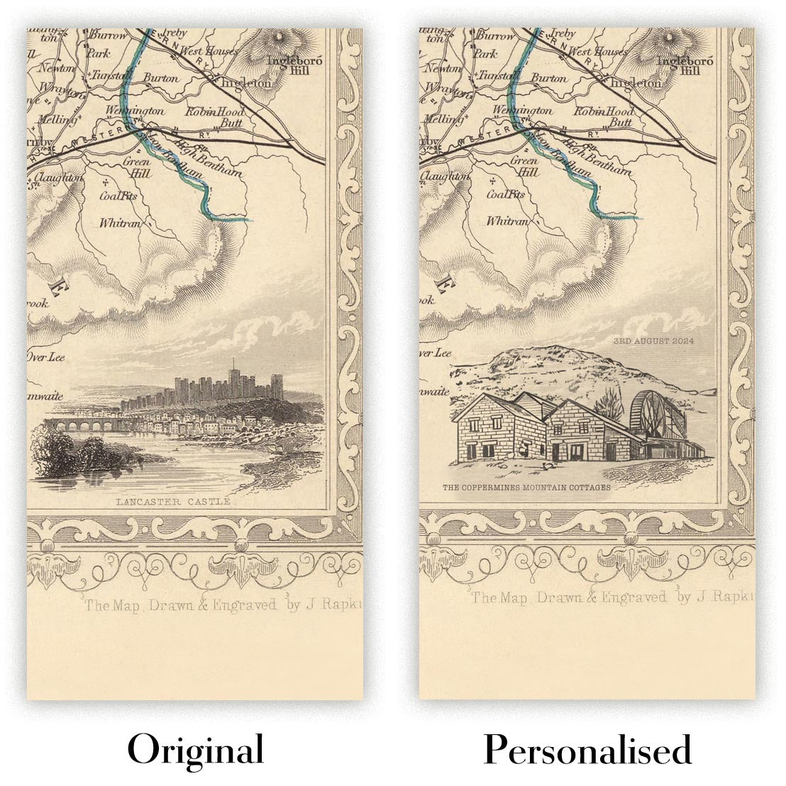
La quinta imagen del anuncio muestra un ejemplo de mi servicio de personalización de mapas.
Si busca algo un poco diferente, eche un vistazo a mi colección de los mejores mapas antiguos para ver si algo más le llama la atención.
Por favor, contácteme para comprobar si una determinada ubicación, hito o elemento aparece en este mapa.
Sería un regalo maravilloso de cumpleaños, Navidad, Día del Padre, despedida del trabajo, aniversario o inauguración de casa para alguien de las zonas cubiertas por este mapa.
Este mapa está disponible como impresión giclée en papel mate de archivo libre de ácido, o puede adquirirse enmarcado. El marco es un elegante y sencillo marco negro que combina con la mayoría de estéticas. Por favor, póngase en contacto si desea un color o material de marco diferente. Mis marcos están acristalados con acrílico de calidad museística ultratransparente (perspex/acrylite), que es significativamente menos reflectante que el vidrio, más seguro y siempre llegará en perfectas condiciones.
This map is also available as a float framed canvas, sometimes known as a shadow gap framed canvas or canvas floater. The map is printed on artist's cotton canvas and then stretched over a handmade box frame. We then "float" the canvas inside a wooden frame, which is available in a range of colours (black, dark brown, oak, antique gold and white). This is a wonderful way to present a map without glazing in front. See some examples of float framed canvas maps and explore the differences between my different finishes.
For something truly unique, this map is also available in "Unique 3D", our trademarked process that dramatically transforms the map so that it has a wonderful sense of depth. We combine the original map with detailed topography and elevation data, so that mountains and the terrain really "pop". For more info and examples of 3D maps, check my Unique 3D page.
Many of our maps and art prints are chosen as thoughtful gifts for homes, offices, studies and meaningful places.
Choose a framed option for the easiest ready-to-hang gift, or choose an unframed print if the recipient may prefer to select their own frame.
We make orders locally in 23 countries around the world, so gifts can often be produced close to the recipient. This helps them arrive faster, travel more safely, and avoid customs or import duty surprises.
- We can deliver directly to the recipient
- Framed pieces arrive ready to hang
- Unframed prints are carefully packed in a strong protective tube
- Almost every order is made locally, for faster, safer gifting
- 90-day returns give the recipient time to decide
If you are not sure what to choose, please contact us. We can help you pick the right map, size, finish or delivery option.
Para la mayoría de los pedidos, el tiempo de entrega es de aproximadamente 3 días laborables. Los productos personalizados y a medida tardan más, ya que tengo que hacer la personalización y enviártelo para su aprobación, lo cual suele tardar 1 o 2 días.
Tenga en cuenta que los pedidos enmarcados muy grandes suelen tardar más en fabricarse y entregarse.
Si necesitas que tu pedido llegue para una fecha determinada, por favor contáctame antes de hacer el pedido para que podamos encontrar la mejor manera de asegurarnos de que recibas tu pedido a tiempo.
Imprimo y enmarco mapas y obras de arte en 23 países alrededor del mundo. Esto significa que tu pedido se fabricará localmente, lo que reduce el tiempo de entrega y asegura que no se dañe durante el envío. Nunca pagarás aranceles de aduana o impuestos de importación, y pondremos menos CO2 en el aire.
Todos mis mapas y impresiones artísticas están bien empaquetados y enviados en un tubo resistente si no están enmarcados, o rodeados de espuma si están enmarcados.
Intento enviar todos los pedidos dentro de 1 o 2 días después de recibir tu pedido, aunque algunos productos (como mascarillas, tazas y bolsas de tela) pueden tardar más en fabricarse.
Si seleccionas Entrega Exprés al finalizar la compra, priorizaremos tu pedido y lo enviaremos por mensajería de 1 día (Fedex, DHL, UPS, Parcelforce).
La entrega al día siguiente también está disponible en algunos países (EE. UU., Reino Unido, Singapur, EAU), pero por favor intenta hacer tu pedido temprano en el día para que podamos enviarlo a tiempo.
Mi marco estándar es un marco de madera de fresno negro estilo galería. Es simple y tiene un aspecto bastante moderno. Mi marco estándar tiene alrededor de 20 mm (0.8 in) de ancho.
Utilizo acrílico super claro (perspex/acrylite) para el vidrio del marco. Es más ligero y seguro que el vidrio, y se ve mejor, ya que la reflectividad es menor.
Seis colores de marco estándar están disponibles de forma gratuita (negro, marrón oscuro, gris oscuro, roble, blanco y oro antiguo).El enmarcado y montaje/matizado personalizado está disponible si buscas algo diferente.
La mayoría de los mapas, arte e ilustraciones también están disponibles como un lienzo enmarcado. Utilizamos lienzo de algodón mate (no brillante), lo estiramos sobre un marco de madera de caja de origen sostenible, y luego 'flotamos' la pieza dentro de un marco de madera. El resultado final es bastante hermoso, y no hay cristal que se interponga.
Todos los marcos se proporcionan "listos para colgar", con una cuerda o soportes en la parte posterior. Los marcos muy grandes tendrán placas de colgar de alta resistencia y/o un listón de montaje. Si tienes alguna pregunta, por favor ponte en contacto.
Mira algunos ejemplos de mis mapas enmarcados y mapas en lienzo enmarcados.
Alternativamente, también puedo proporcionar mapas antiguos y obras de arte en lienzo, tablero de espuma, papel de algodón y otros materiales.
Si deseas enmarcar tu mapa o obra de arte tú mismo, por favor lee mi guía de tamaños primero.
Mis mapas son reproducciones de mapas originales de altísima calidad.
Obtengo mapas originales y raros de bibliotecas, casas de subastas y colecciones privadas de todo el mundo, los restauro en mi taller de Londres y luego uso tintas e impresoras giclée especializadas para crear hermosos mapas que lucen incluso mejor que el original.
Mis mapas están impresos en papel de archivo mate (no brillante) sin ácido que se siente de muy alta calidad y casi como una tarjeta. En términos técnicos, el peso/grosor del papel es de 10 mil/200 g/m². Es perfecto para enmarcar.
Imprimo con tintas pigmentadas Epson ultrachrome giclée UV resistentes a la decoloración, algunas de las mejores tintas que puedes encontrar.
yo también puedo hacer mapas sobre lienzo, trapo de algodón y otros materiales exóticos.
Obtenga más información sobre The Unique Maps Co..
Personalización de mapas
Si está buscando el regalo perfecto de aniversario o inauguración de la casa, puedo personalizar su mapa para hacerlo verdaderamente único. Por ejemplo, puedo agregar un mensaje corto, resaltar una ubicación importante o agregar el escudo de armas de su familia.
Las opciones son casi infinitas. Por favor mira mi página de personalización de mapas para ver algunos maravillosos ejemplos de lo que es posible.
Para pedir un mapa personalizado, seleccione "personalizar su mapa" antes de agregarlo a su carrito.
Ponerse en contacto si buscas personalizaciones y personalizaciones más complejas.
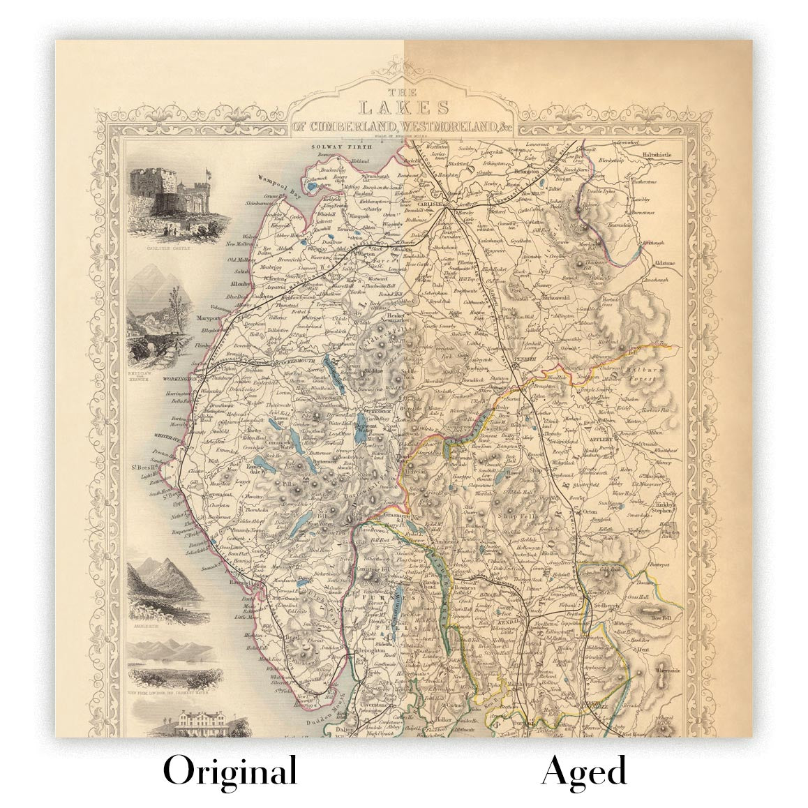
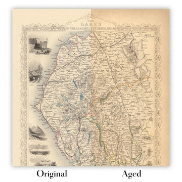
Envejecimiento del mapa
A lo largo de los años, los clientes me han preguntado cientos de veces si podían comprar un mapa que se viera uniforme. más viejo.
Bueno, ahora puedes hacerlo seleccionando Envejecido antes de agregar un mapa a tu carrito.
Todas las fotografías de productos que ve en esta página muestran el mapa en su forma original. Así es como se ve el mapa hoy.
Si selecciona Envejecido, envejeceré su mapa a mano, usando un proceso especial y único desarrollado a través de años de estudiar mapas antiguos, hablar con investigadores para comprender la química del envejecimiento del papel y, por supuesto... ¡mucha práctica!
Si no estás seguro, quédate con el color original del mapa. Si quieres algo un poco más oscuro y más viejo buscando, opte por Envejecido.
Si no estás satisfecho con tu pedido por cualquier motivo, contáctame para un reembolso sin complicaciones. Por favor, consulta nuestra política de devoluciones y reembolsos para más información.
Estoy muy seguro de que te gustará tu mapa o impresión artística restaurada. He estado haciendo esto desde 1984. Soy un vendedor de 5 estrellas en Etsy. He vendido decenas de miles de mapas e impresiones artísticas y tengo más de 5,000 opiniones reales de 5 estrellas.
Utilizo un proceso único para restaurar mapas y obras de arte que consume mucho tiempo y mano de obra. Buscar los mapas e ilustraciones originales puede llevar meses. Utilizo tecnología de última generación y extremadamente cara para escanear y restaurarlos. Como resultado, garantizo que mis mapas e impresiones artísticas son superiores a los demás - por eso puedo ofrecer un reembolso sin complicaciones.
Casi todos mis mapas e impresiones artísticas se ven increíbles en tamaños grandes (200cm, 6.5ft+) y también puedo enmarcarlos y entregártelos a través de un servicio de mensajería especial para tamaños grandes. Contáctame para discutir tus necesidades específicas.
Or try searching for something!


