


Mapa antiguo de las Islas Británicas de Tallis, 1851: El último gran mapa decorativo
20% de descuento en 2 — 33% de descuento en 3
Añade dos artículos elegibles a tu carrito para recibir 20% de descuento. Añade un tercero y será complementario (equivalente a 33% de descuento al comprar tres).
No se necesita código — la oferta se aplica automáticamente al finalizar la compra.
Válido en todos los mapas estándar y impresiones de arte fino. Puedes mezclar y combinar cualquier diseño.
Si deseas enviar artículos a múltiples direcciones, por favor contáctanos antes de realizar tu pedido.
Las comisiones personalizadas y a medida están excluidas.
Contáctanos si tienes alguna pregunta

Restaurado a partir del mapa original de 1851 e impreso en calidad museo. Leer la historia detrás de este mapa
Choose your size
Choose your finish


(Más información)
Mensaje de regalo y acabado personalizado

Si deseas agregar un mensaje de regalo, o un acabado (rompecabezas, tablero de aluminio, etc.) que no esté disponible aquí, por favor solicítalo en la "nota del pedido" cuando realices la compra.
Cada pedido es hecho a medida, así que si necesitas que el tamaño se ajuste ligeramente, o que se imprima en un material inusual, háznoslo saber. Hemos realizado miles de pedidos personalizados a lo largo de los años, así que hay (casi) nada que no podamos gestionar.
También puedes contactarnos antes de hacer tu pedido, ¡si lo prefieres!

- Hecho localmente. Entrega segura
- Sin aranceles ni cargos ocultos
- ¿Necesitas ayuda? Llámanos o mensaje por WhatsApp
Own a piece of history
8,000+ five-star reviews


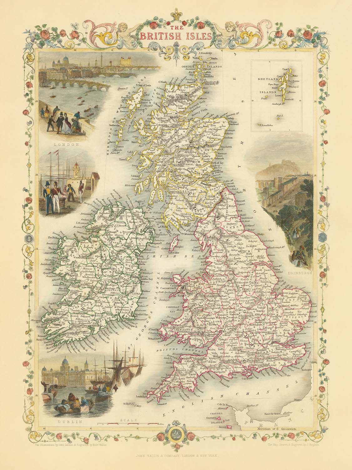
Adéntrese en la grandeza de la cartografía victoriana con “The British Isles”, una obra maestra de 1851 del célebre cartógrafo John Tallis....
Seguir leyendoAdéntrese en la grandeza de la cartografía victoriana con “The British Isles”, una obra maestra de 1851 del célebre cartógrafo John Tallis. Este mapa, grabado originalmente para el Illustrated Atlas de R. Montgomery Martin, es un testimonio del arte y la precisión que definieron la ilustre carrera de Tallis. El título original del mapa —“The British Isles”— refleja tanto su amplitud de alcance como la profunda conexión de su creador con su tierra natal. Cada detalle, desde los condados meticulosamente delimitados hasta el elegante borde decorativo, le invita a explorar una etapa crucial de la historia británica, cuando las islas eran el corazón de un imperio global y el oficio del cartógrafo alcanzaba su cenit.
John Tallis, reconocido como uno de los últimos grandes cartógrafos decorativos, impregnó sus obras tanto de exactitud científica como de esplendor estético. Sus mapas son apreciados no solo por su detalle geográfico, sino también por sus evocadoras viñetas —impresionantes ilustraciones que capturan el espíritu y el carácter de las tierras que representan. En este mapa encontrará exquisitas escenas de Londres, Edimburgo y Dublín, cada una plasmada con una sensibilidad romántica que transporta al espectador al bullicioso corazón de estas ciudades históricas. La dedicación de Tallis tanto a la belleza como a la precisión hace de este mapa un ejemplo esencial de la excelencia cartográfica del siglo XIX.
El detalle político del mapa es inmediatamente impactante, con Inglaterra, Escocia, Irlanda y Gales representadas cada una en colores distintos y subdivididas además en sus condados históricos. Las fronteras están nítidamente definidas, ofreciendo una fascinante visión de la geografía administrativa de mediados del siglo XIX. Un recuadro de las Islas Shetland adorna la esquina superior derecha, asegurando que incluso los confines más remotos de las Islas Británicas estén representados. Esta atención a la identidad regional y local habla del valor del mapa tanto como documento histórico como obra de arte.
Más allá de sus divisiones políticas, el mapa es rico en geografía física. Las cordilleras, como las que se encuentran en Escocia y Gales, se representan con un delicado relieve sombreado, insinuando el terreno escarpado que ha dado forma al carácter y la historia de estas tierras. Las principales masas de agua —el mar de Irlanda, el mar del Norte, el canal de la Mancha y el océano Atlántico— enmarcan las islas, mientras que la Isla de Man y las Islas del Canal también aparecen de forma destacada. La interacción entre paisajes naturales y humanos convierte este mapa en un estudio cautivador del perdurable encanto de las Islas Británicas.
Quizá lo más encantador sea el catálogo de asentamientos del mapa, desde la imponente metrópoli de Londres hasta las célebres ciudades de Glasgow, Edimburgo, Dublín y Belfast. También se señalan cuidadosamente localidades más pequeñas y centros regionales, como York, Bath, Cardiff y Cork, ofreciendo un rico tapiz de la vida urbana tal como se conocía en la década de 1850. Tanto si es amante de la historia, conocedor de la cartografía fina o coleccionista en busca de una ventana al pasado, “The British Isles” de John Tallis es una obra de rara belleza y perdurable importancia.
Ciudades y localidades en este mapa
- Inglaterra
- Londres
- Birmingham
- Manchester
- Liverpool
- Leeds
- Sheffield
- Bristol
- Newcastle (Newcastle upon Tyne)
- Nottingham
- Southampton
- Portsmouth
- Plymouth
- Norwich
- York
- Exeter
- Bath
- Oxford
- Cambridge
- Derby
- Leicester
- Hull (Kingston upon Hull)
- Sunderland
- Carlisle
- Gloucester
- Lincoln
- Chester
- Worcester
- Hereford
- Shrewsbury
- Lancaster
- Durham
-
Salisbury
-
Escocia
- Glasgow
- Edimburgo
- Aberdeen
- Dundee
- Inverness
- Perth
- Stirling
-
Dumfries
-
Gales
- Cardiff
- Swansea
- Newport
- Wrexham
- Bangor
-
St. David's
-
Irlanda (actualmente República de Irlanda e Irlanda del Norte)
- Dublín
- Belfast
- Cork
- Limerick
- Galway
- Waterford
- Londonderry (Derry)
- Kilkenny
- Armagh
- Sligo
- Ennis
-
Tralee
-
Isla de Man
-
Douglas
-
Islas del Canal
- St. Helier (Jersey)
- St. Peter Port (Guernsey)
Características destacadas y puntos de interés
- Mapa insertado de las islas Shetland (esquina superior derecha)
- Ilustraciones decorativas en viñetas:
- Dos escenas de Londres (incluida la Torre de Londres y el Palacio de Westminster)
- Una escena de Edimburgo (castillo de Edimburgo)
- Una escena de Dublín (vista de la ciudad)
- Fronteras entre Inglaterra, Escocia, Irlanda y Gales, claramente delimitadas y codificadas por colores
- Límites condales dentro de cada región, con los condados etiquetados
- Principales masas de agua:
- El mar de Irlanda
- El mar del Norte
- El canal de la Mancha
- El océano Atlántico
- Cadenas montañosas indicadas con relieve sombreado (por ejemplo, en Escocia y Gales)
- La isla de Man y las Islas del Canal representadas
- Borde decorativo que rodea el mapa
Contexto histórico y de diseño
- Nombre del mapa: Las Islas Británicas
- Cartógrafo: John Tallis, un reconocido cartógrafo y editor británico del siglo XIX, conocido por sus mapas muy decorativos y detallados
- Fecha de creación: 1851
- Editor/Grabador: Creado para el Atlas Ilustrado de R. Montgomery Martin
- Tipo de mapa: Mapa político y físico detallado de las Islas Británicas
- Regiones representadas: El mapa abarca las Islas Británicas, incluidas Inglaterra, Escocia, Irlanda y Gales, así como la Isla de Man y las Islas del Canal
- Subdivisiones: Las regiones principales están coloreadas distintivamente y subdivididas además en sus condados históricos
- Elementos decorativos: Presenta impactantes viñetas decorativas que muestran el estilo artístico distintivo de Tallis
- Diseño/estilo: Característico de la obra de Tallis, con bordes elaborados, divisiones condales detalladas e ilustraciones artísticas de escenas locales, personas y artefactos
- Contexto histórico: Creado durante la época victoriana, un período de importantes cambios políticos, sociales e industriales en las Islas Británicas
- Importancia: Ofrece una instantánea de la geografía política de las Islas Británicas a mediados del siglo XIX, reflejando las divisiones administrativas y las sensibilidades artísticas de la época
Please double check the images to make sure that a specific town or place is shown on this map. You can also get in touch and ask us to check the map for you.
This map looks great at every size, but I always recommend going for a larger size if you have space. That way you can easily make out all of the details.
Este mapa se ve increíble en tamaños de hasta 50in (125cm). Si busca un mapa de mayor tamaño, por favor póngase en contacto.
El modelo en las imágenes del anuncio sostiene la versión de 18x24in (45x60cm) de este mapa.
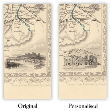
La quinta imagen del anuncio muestra un ejemplo de mi servicio de personalización de mapas.
Si busca algo ligeramente diferente, consulte mi colección de los mejores mapas antiguos para ver si algo más llama su atención.
Por favor, contácteme para comprobar si una determinada ubicación, hito o característica aparece en este mapa.
Sería un maravilloso regalo de cumpleaños, Navidad, Día del Padre, despedida del trabajo, aniversario o inauguración de casa para alguien de las zonas abarcadas por este mapa.
Este mapa está disponible como impresión giclée en papel mate de archivo libre de ácido, o puede comprarlo enmarcado. El marco es un bonito y sencillo marco negro que se adapta a la mayoría de los estilos. Por favor, póngase en contacto si desea un color o material de marco diferente. Mis marcos están protegidos con acrílico de calidad museística de gran claridad (perspex/acrylite), que es considerablemente menos reflectante que el vidrio, más seguro y siempre llegará en perfectas condiciones.
This map is also available as a float framed canvas, sometimes known as a shadow gap framed canvas or canvas floater. The map is printed on artist's cotton canvas and then stretched over a handmade box frame. We then "float" the canvas inside a wooden frame, which is available in a range of colours (black, dark brown, oak, antique gold and white). This is a wonderful way to present a map without glazing in front. See some examples of float framed canvas maps and explore the differences between my different finishes.
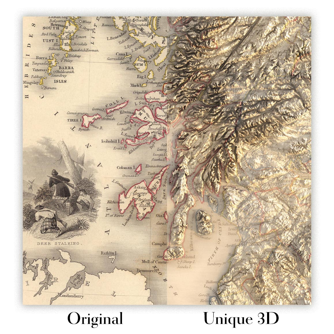
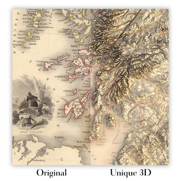
For something truly unique, this map is also available in "Unique 3D", our trademarked process that dramatically transforms the map so that it has a wonderful sense of depth. We combine the original map with detailed topography and elevation data, so that mountains and the terrain really "pop". For more info and examples of 3D maps, check my Unique 3D page.
Adéntrese en la grandeza de la cartografía victoriana con “The British Isles”, una obra maestra de 1851 del célebre cartógrafo John Tallis. Este mapa, grabado originalmente para el Illustrated Atlas de R. Montgomery Martin, es un testimonio del arte y la precisión que definieron la ilustre carrera de Tallis. El título original del mapa —“The British Isles”— refleja tanto su amplitud de alcance como la profunda conexión de su creador con su tierra natal. Cada detalle, desde los condados meticulosamente delimitados hasta el elegante borde decorativo, le invita a explorar una etapa crucial de la historia británica, cuando las islas eran el corazón de un imperio global y el oficio del cartógrafo alcanzaba su cenit.
John Tallis, reconocido como uno de los últimos grandes cartógrafos decorativos, impregnó sus obras tanto de exactitud científica como de esplendor estético. Sus mapas son apreciados no solo por su detalle geográfico, sino también por sus evocadoras viñetas —impresionantes ilustraciones que capturan el espíritu y el carácter de las tierras que representan. En este mapa encontrará exquisitas escenas de Londres, Edimburgo y Dublín, cada una plasmada con una sensibilidad romántica que transporta al espectador al bullicioso corazón de estas ciudades históricas. La dedicación de Tallis tanto a la belleza como a la precisión hace de este mapa un ejemplo esencial de la excelencia cartográfica del siglo XIX.
El detalle político del mapa es inmediatamente impactante, con Inglaterra, Escocia, Irlanda y Gales representadas cada una en colores distintos y subdivididas además en sus condados históricos. Las fronteras están nítidamente definidas, ofreciendo una fascinante visión de la geografía administrativa de mediados del siglo XIX. Un recuadro de las Islas Shetland adorna la esquina superior derecha, asegurando que incluso los confines más remotos de las Islas Británicas estén representados. Esta atención a la identidad regional y local habla del valor del mapa tanto como documento histórico como obra de arte.
Más allá de sus divisiones políticas, el mapa es rico en geografía física. Las cordilleras, como las que se encuentran en Escocia y Gales, se representan con un delicado relieve sombreado, insinuando el terreno escarpado que ha dado forma al carácter y la historia de estas tierras. Las principales masas de agua —el mar de Irlanda, el mar del Norte, el canal de la Mancha y el océano Atlántico— enmarcan las islas, mientras que la Isla de Man y las Islas del Canal también aparecen de forma destacada. La interacción entre paisajes naturales y humanos convierte este mapa en un estudio cautivador del perdurable encanto de las Islas Británicas.
Quizá lo más encantador sea el catálogo de asentamientos del mapa, desde la imponente metrópoli de Londres hasta las célebres ciudades de Glasgow, Edimburgo, Dublín y Belfast. También se señalan cuidadosamente localidades más pequeñas y centros regionales, como York, Bath, Cardiff y Cork, ofreciendo un rico tapiz de la vida urbana tal como se conocía en la década de 1850. Tanto si es amante de la historia, conocedor de la cartografía fina o coleccionista en busca de una ventana al pasado, “The British Isles” de John Tallis es una obra de rara belleza y perdurable importancia.
Ciudades y localidades en este mapa
- Inglaterra
- Londres
- Birmingham
- Manchester
- Liverpool
- Leeds
- Sheffield
- Bristol
- Newcastle (Newcastle upon Tyne)
- Nottingham
- Southampton
- Portsmouth
- Plymouth
- Norwich
- York
- Exeter
- Bath
- Oxford
- Cambridge
- Derby
- Leicester
- Hull (Kingston upon Hull)
- Sunderland
- Carlisle
- Gloucester
- Lincoln
- Chester
- Worcester
- Hereford
- Shrewsbury
- Lancaster
- Durham
-
Salisbury
-
Escocia
- Glasgow
- Edimburgo
- Aberdeen
- Dundee
- Inverness
- Perth
- Stirling
-
Dumfries
-
Gales
- Cardiff
- Swansea
- Newport
- Wrexham
- Bangor
-
St. David's
-
Irlanda (actualmente República de Irlanda e Irlanda del Norte)
- Dublín
- Belfast
- Cork
- Limerick
- Galway
- Waterford
- Londonderry (Derry)
- Kilkenny
- Armagh
- Sligo
- Ennis
-
Tralee
-
Isla de Man
-
Douglas
-
Islas del Canal
- St. Helier (Jersey)
- St. Peter Port (Guernsey)
Características destacadas y puntos de interés
- Mapa insertado de las islas Shetland (esquina superior derecha)
- Ilustraciones decorativas en viñetas:
- Dos escenas de Londres (incluida la Torre de Londres y el Palacio de Westminster)
- Una escena de Edimburgo (castillo de Edimburgo)
- Una escena de Dublín (vista de la ciudad)
- Fronteras entre Inglaterra, Escocia, Irlanda y Gales, claramente delimitadas y codificadas por colores
- Límites condales dentro de cada región, con los condados etiquetados
- Principales masas de agua:
- El mar de Irlanda
- El mar del Norte
- El canal de la Mancha
- El océano Atlántico
- Cadenas montañosas indicadas con relieve sombreado (por ejemplo, en Escocia y Gales)
- La isla de Man y las Islas del Canal representadas
- Borde decorativo que rodea el mapa
Contexto histórico y de diseño
- Nombre del mapa: Las Islas Británicas
- Cartógrafo: John Tallis, un reconocido cartógrafo y editor británico del siglo XIX, conocido por sus mapas muy decorativos y detallados
- Fecha de creación: 1851
- Editor/Grabador: Creado para el Atlas Ilustrado de R. Montgomery Martin
- Tipo de mapa: Mapa político y físico detallado de las Islas Británicas
- Regiones representadas: El mapa abarca las Islas Británicas, incluidas Inglaterra, Escocia, Irlanda y Gales, así como la Isla de Man y las Islas del Canal
- Subdivisiones: Las regiones principales están coloreadas distintivamente y subdivididas además en sus condados históricos
- Elementos decorativos: Presenta impactantes viñetas decorativas que muestran el estilo artístico distintivo de Tallis
- Diseño/estilo: Característico de la obra de Tallis, con bordes elaborados, divisiones condales detalladas e ilustraciones artísticas de escenas locales, personas y artefactos
- Contexto histórico: Creado durante la época victoriana, un período de importantes cambios políticos, sociales e industriales en las Islas Británicas
- Importancia: Ofrece una instantánea de la geografía política de las Islas Británicas a mediados del siglo XIX, reflejando las divisiones administrativas y las sensibilidades artísticas de la época
Please double check the images to make sure that a specific town or place is shown on this map. You can also get in touch and ask us to check the map for you.
This map looks great at every size, but I always recommend going for a larger size if you have space. That way you can easily make out all of the details.
Este mapa se ve increíble en tamaños de hasta 50in (125cm). Si busca un mapa de mayor tamaño, por favor póngase en contacto.
El modelo en las imágenes del anuncio sostiene la versión de 18x24in (45x60cm) de este mapa.
La quinta imagen del anuncio muestra un ejemplo de mi servicio de personalización de mapas.
Si busca algo ligeramente diferente, consulte mi colección de los mejores mapas antiguos para ver si algo más llama su atención.
Por favor, contácteme para comprobar si una determinada ubicación, hito o característica aparece en este mapa.
Sería un maravilloso regalo de cumpleaños, Navidad, Día del Padre, despedida del trabajo, aniversario o inauguración de casa para alguien de las zonas abarcadas por este mapa.
Este mapa está disponible como impresión giclée en papel mate de archivo libre de ácido, o puede comprarlo enmarcado. El marco es un bonito y sencillo marco negro que se adapta a la mayoría de los estilos. Por favor, póngase en contacto si desea un color o material de marco diferente. Mis marcos están protegidos con acrílico de calidad museística de gran claridad (perspex/acrylite), que es considerablemente menos reflectante que el vidrio, más seguro y siempre llegará en perfectas condiciones.
This map is also available as a float framed canvas, sometimes known as a shadow gap framed canvas or canvas floater. The map is printed on artist's cotton canvas and then stretched over a handmade box frame. We then "float" the canvas inside a wooden frame, which is available in a range of colours (black, dark brown, oak, antique gold and white). This is a wonderful way to present a map without glazing in front. See some examples of float framed canvas maps and explore the differences between my different finishes.
For something truly unique, this map is also available in "Unique 3D", our trademarked process that dramatically transforms the map so that it has a wonderful sense of depth. We combine the original map with detailed topography and elevation data, so that mountains and the terrain really "pop". For more info and examples of 3D maps, check my Unique 3D page.
Many of our maps and art prints are chosen as thoughtful gifts for homes, offices, studies and meaningful places.
Choose a framed option for the easiest ready-to-hang gift, or choose an unframed print if the recipient may prefer to select their own frame.
We make orders locally in 23 countries around the world, so gifts can often be produced close to the recipient. This helps them arrive faster, travel more safely, and avoid customs or import duty surprises.
- We can deliver directly to the recipient
- Framed pieces arrive ready to hang
- Unframed prints are carefully packed in a strong protective tube
- Almost every order is made locally, for faster, safer gifting
- 90-day returns give the recipient time to decide
If you are not sure what to choose, please contact us. We can help you pick the right map, size, finish or delivery option.
Para la mayoría de los pedidos, el tiempo de entrega es de aproximadamente 3 días laborables. Los productos personalizados y a medida tardan más, ya que tengo que hacer la personalización y enviártelo para su aprobación, lo cual suele tardar 1 o 2 días.
Tenga en cuenta que los pedidos enmarcados muy grandes suelen tardar más en fabricarse y entregarse.
Si necesitas que tu pedido llegue para una fecha determinada, por favor contáctame antes de hacer el pedido para que podamos encontrar la mejor manera de asegurarnos de que recibas tu pedido a tiempo.
Imprimo y enmarco mapas y obras de arte en 23 países alrededor del mundo. Esto significa que tu pedido se fabricará localmente, lo que reduce el tiempo de entrega y asegura que no se dañe durante el envío. Nunca pagarás aranceles de aduana o impuestos de importación, y pondremos menos CO2 en el aire.
Todos mis mapas y impresiones artísticas están bien empaquetados y enviados en un tubo resistente si no están enmarcados, o rodeados de espuma si están enmarcados.
Intento enviar todos los pedidos dentro de 1 o 2 días después de recibir tu pedido, aunque algunos productos (como mascarillas, tazas y bolsas de tela) pueden tardar más en fabricarse.
Si seleccionas Entrega Exprés al finalizar la compra, priorizaremos tu pedido y lo enviaremos por mensajería de 1 día (Fedex, DHL, UPS, Parcelforce).
La entrega al día siguiente también está disponible en algunos países (EE. UU., Reino Unido, Singapur, EAU), pero por favor intenta hacer tu pedido temprano en el día para que podamos enviarlo a tiempo.
Mi marco estándar es un marco de madera de fresno negro estilo galería. Es simple y tiene un aspecto bastante moderno. Mi marco estándar tiene alrededor de 20 mm (0.8 in) de ancho.
Utilizo acrílico super claro (perspex/acrylite) para el vidrio del marco. Es más ligero y seguro que el vidrio, y se ve mejor, ya que la reflectividad es menor.
Seis colores de marco estándar están disponibles de forma gratuita (negro, marrón oscuro, gris oscuro, roble, blanco y oro antiguo).El enmarcado y montaje/matizado personalizado está disponible si buscas algo diferente.
La mayoría de los mapas, arte e ilustraciones también están disponibles como un lienzo enmarcado. Utilizamos lienzo de algodón mate (no brillante), lo estiramos sobre un marco de madera de caja de origen sostenible, y luego 'flotamos' la pieza dentro de un marco de madera. El resultado final es bastante hermoso, y no hay cristal que se interponga.
Todos los marcos se proporcionan "listos para colgar", con una cuerda o soportes en la parte posterior. Los marcos muy grandes tendrán placas de colgar de alta resistencia y/o un listón de montaje. Si tienes alguna pregunta, por favor ponte en contacto.
Mira algunos ejemplos de mis mapas enmarcados y mapas en lienzo enmarcados.
Alternativamente, también puedo proporcionar mapas antiguos y obras de arte en lienzo, tablero de espuma, papel de algodón y otros materiales.
Si deseas enmarcar tu mapa o obra de arte tú mismo, por favor lee mi guía de tamaños primero.
Mis mapas son reproducciones de mapas originales de altísima calidad.
Obtengo mapas originales y raros de bibliotecas, casas de subastas y colecciones privadas de todo el mundo, los restauro en mi taller de Londres y luego uso tintas e impresoras giclée especializadas para crear hermosos mapas que lucen incluso mejor que el original.
Mis mapas están impresos en papel de archivo mate (no brillante) sin ácido que se siente de muy alta calidad y casi como una tarjeta. En términos técnicos, el peso/grosor del papel es de 10 mil/200 g/m². Es perfecto para enmarcar.
Imprimo con tintas pigmentadas Epson ultrachrome giclée UV resistentes a la decoloración, algunas de las mejores tintas que puedes encontrar.
yo también puedo hacer mapas sobre lienzo, trapo de algodón y otros materiales exóticos.
Obtenga más información sobre The Unique Maps Co..
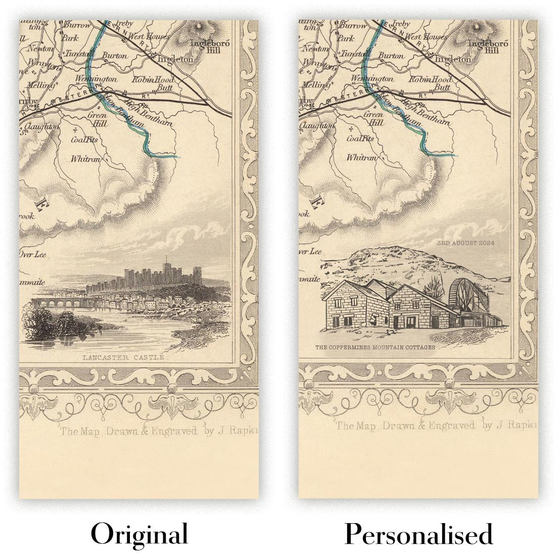
Personalización de mapas
Si está buscando el regalo perfecto de aniversario o inauguración de la casa, puedo personalizar su mapa para hacerlo verdaderamente único. Por ejemplo, puedo agregar un mensaje corto, resaltar una ubicación importante o agregar el escudo de armas de su familia.
Las opciones son casi infinitas. Por favor mira mi página de personalización de mapas para ver algunos maravillosos ejemplos de lo que es posible.
Para pedir un mapa personalizado, seleccione "personalizar su mapa" antes de agregarlo a su carrito.
Ponerse en contacto si buscas personalizaciones y personalizaciones más complejas.
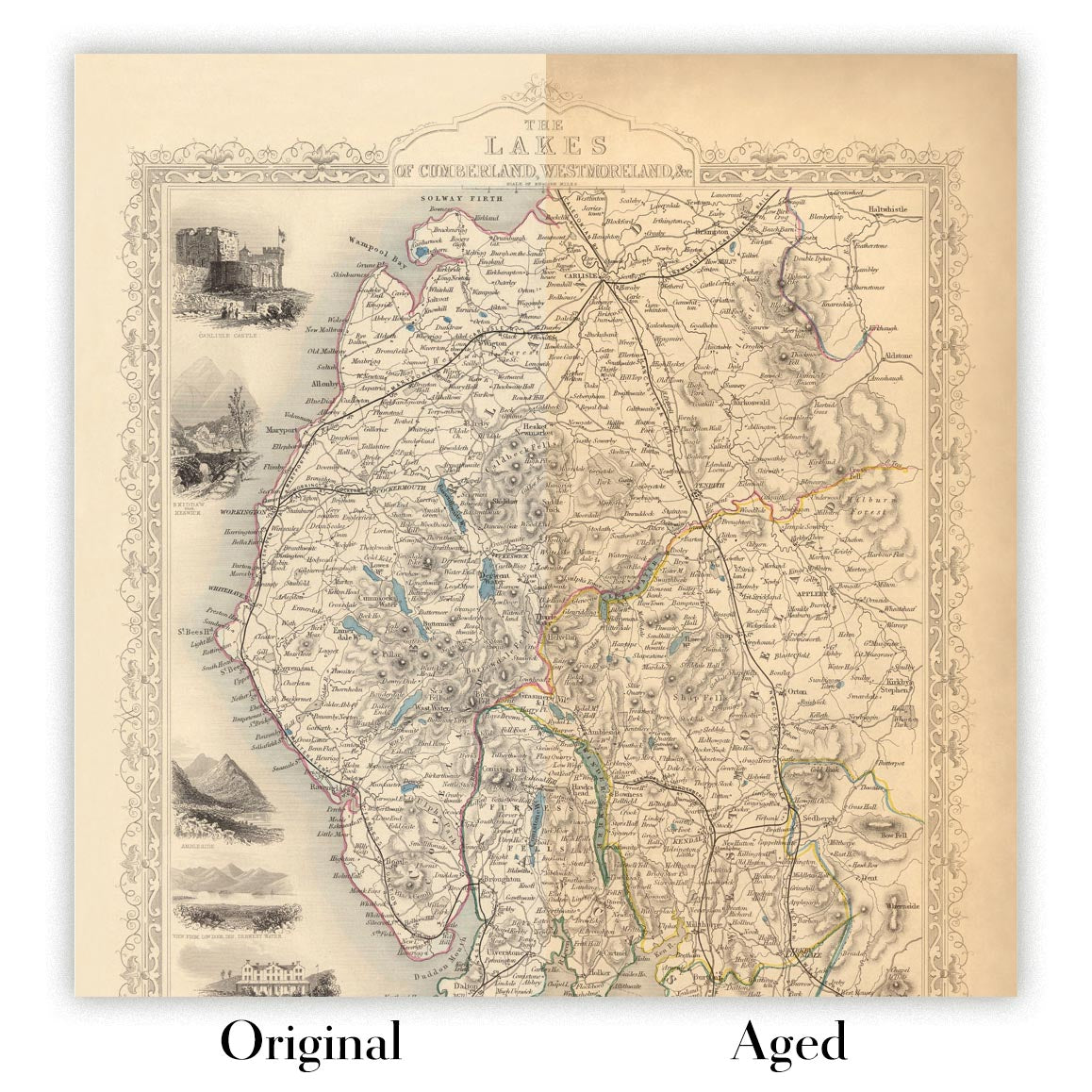
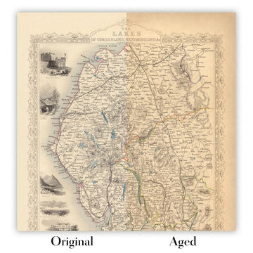
Envejecimiento del mapa
A lo largo de los años, los clientes me han preguntado cientos de veces si podían comprar un mapa que se viera uniforme. más viejo.
Bueno, ahora puedes hacerlo seleccionando Envejecido antes de agregar un mapa a tu carrito.
Todas las fotografías de productos que ve en esta página muestran el mapa en su forma original. Así es como se ve el mapa hoy.
Si selecciona Envejecido, envejeceré su mapa a mano, usando un proceso especial y único desarrollado a través de años de estudiar mapas antiguos, hablar con investigadores para comprender la química del envejecimiento del papel y, por supuesto... ¡mucha práctica!
Si no estás seguro, quédate con el color original del mapa. Si quieres algo un poco más oscuro y más viejo buscando, opte por Envejecido.
Si no estás satisfecho con tu pedido por cualquier motivo, contáctame para un reembolso sin complicaciones. Por favor, consulta nuestra política de devoluciones y reembolsos para más información.
Estoy muy seguro de que te gustará tu mapa o impresión artística restaurada. He estado haciendo esto desde 1984. Soy un vendedor de 5 estrellas en Etsy. He vendido decenas de miles de mapas e impresiones artísticas y tengo más de 5,000 opiniones reales de 5 estrellas.
Utilizo un proceso único para restaurar mapas y obras de arte que consume mucho tiempo y mano de obra. Buscar los mapas e ilustraciones originales puede llevar meses. Utilizo tecnología de última generación y extremadamente cara para escanear y restaurarlos. Como resultado, garantizo que mis mapas e impresiones artísticas son superiores a los demás - por eso puedo ofrecer un reembolso sin complicaciones.
Casi todos mis mapas e impresiones artísticas se ven increíbles en tamaños grandes (200cm, 6.5ft+) y también puedo enmarcarlos y entregártelos a través de un servicio de mensajería especial para tamaños grandes. Contáctame para discutir tus necesidades específicas.
Or try searching for something!


