


Antiguo mapa pictórico de Francia de Lucien Boucher, 1950: Alpes, Pirineos, agricultura, uvas
La oferta del coleccionista
Elija dos obras elegibles y obtenga un 20 % de descuento en ambas. Elija tres y la de menor precio será gratuita, con un ahorro máximo del 33 %.
Combine y mezcle mapas estándar elegibles y reproducciones de bellas artes. No se requiere código; la oferta se aplica automáticamente al finalizar la compra.
Se incluyen las configuraciones estándar hechas por encargo. Quedan excluidos los tamaños a medida, los diseños personalizados y los trabajos por encargo.
¿Necesita entrega en diferentes direcciones? Contáctenos antes de realizar el pedido.La oferta del coleccionista
Elija dos obras elegibles y obtenga un 20 % de descuento en ambas. Elija tres y la de menor precio será gratuita, con un ahorro máximo del 33 %.
Combine y mezcle mapas estándar elegibles y reproducciones de bellas artes. No se requiere código; la oferta se aplica automáticamente al finalizar la compra.
Se incluyen las configuraciones estándar hechas por encargo. Quedan excluidos los tamaños a medida, los diseños personalizados y los trabajos por encargo.
¿Necesita entrega en diferentes direcciones? Contáctenos antes de realizar el pedido.
Restaurado a partir del mapa original de 1950 e impreso en calidad museo. Leer la historia detrás de este mapa
Choose your size
Choose your finish


(Más información)
Mensaje de regalo y acabado personalizado

Si deseas agregar un mensaje de regalo, o un acabado (rompecabezas, tablero de aluminio, etc.) que no esté disponible aquí, por favor solicítalo en la "nota del pedido" cuando realices la compra.
Cada pedido es hecho a medida, así que si necesitas que el tamaño se ajuste ligeramente, o que se imprima en un material inusual, háznoslo saber. Hemos realizado miles de pedidos personalizados a lo largo de los años, así que hay (casi) nada que no podamos gestionar.
También puedes contactarnos antes de hacer tu pedido, ¡si lo prefieres!

- Hecho localmente. Entrega segura
- Sin aranceles ni cargos ocultos
- ¿Necesitas ayuda? Llámanos o mensaje por WhatsApp
Own a piece of history
8,000+ five-star reviews


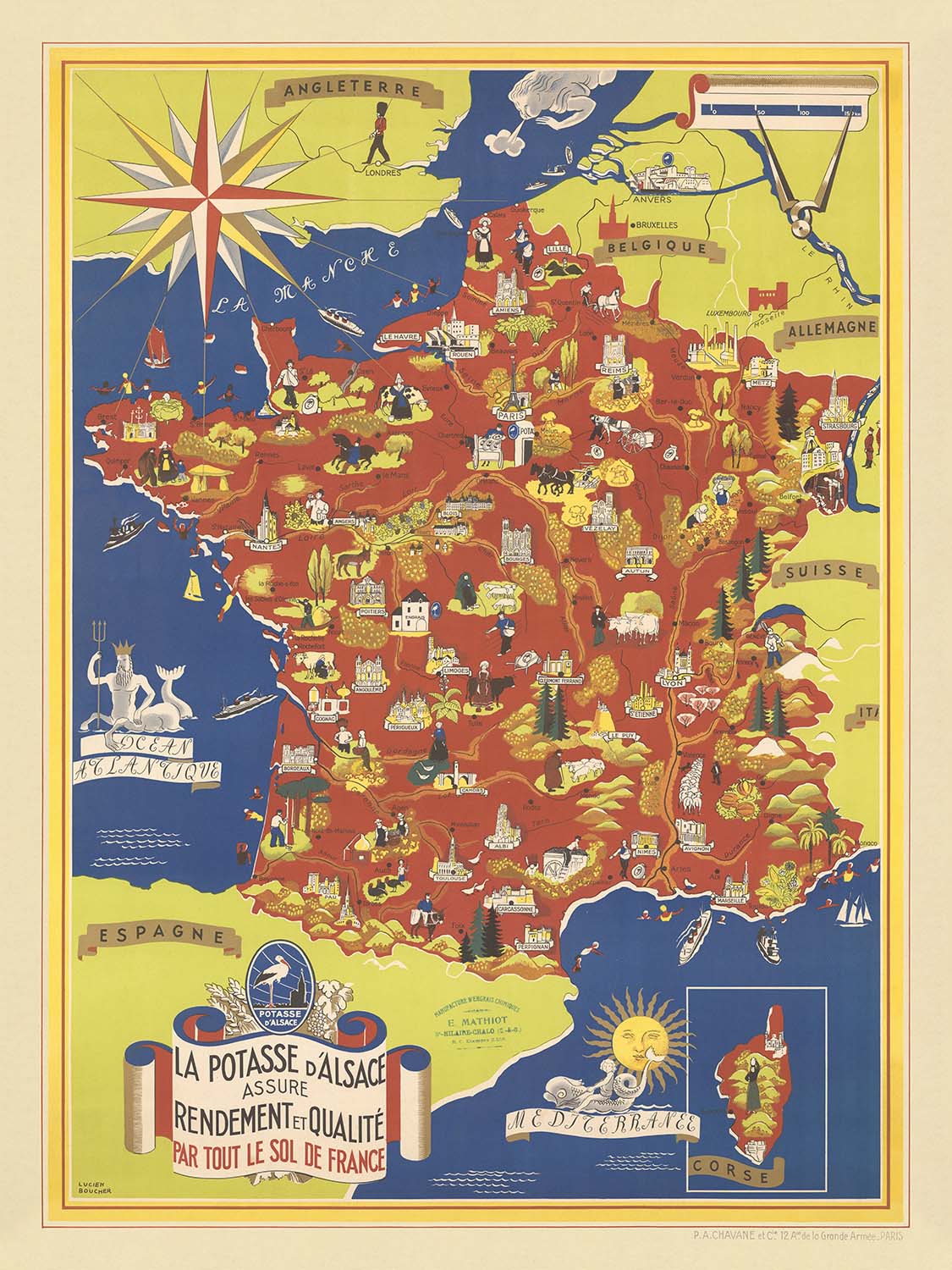
Adéntrese en el vibrante mundo de la cartografía francesa de mediados del siglo XX con "La Potasse D'Alsace Assure Rendement et Qualite...
Seguir leyendoAdéntrese en el vibrante mundo de la cartografía francesa de mediados del siglo XX con "La Potasse D'Alsace Assure Rendement et Qualite Par Tout Le Sol De France," un cautivador mapa pictórico creado por el célebre artista Lucien Boucher en 1950. Esta obra es más que un mapa: es un manifiesto visual que ensalza la abundancia agrícola aportada por la renombrada potasa de Alsacia. El título original en francés, elegantemente dispuesto en una banda decorativa, encapsula el optimismo de la Francia de posguerra, cuando la innovación científica y el orgullo regional convergieron para prometer abundancia y renovación en los fértiles suelos de la nación.
Lucien Boucher, el cartógrafo detrás de esta pieza, es reverenciado por su enfoque imaginativo y decorativo de la cartografía. Conocido sobre todo por sus icónicos mapas de Air France, Boucher aportó a cada proyecto una combinación única de arte e información. Aquí, su estilo distintivo es inconfundible: amplias ilustraciones, paletas de color vibrantes y un equilibrio armónico entre precisión geográfica y ornamento artístico. La obra de Boucher invita al espectador a recorrer Francia no solo como un paisaje, sino como un tableau vivo y palpitante de riqueza agrícola y carácter regional.
El diseño del mapa es una celebración de la diversa geografía de Francia, con cada región representada con exquisito detalle. Desde los Alpes nevados y los escarpados Pirineos hasta las suaves ondulaciones del Macizo Central y los verdes Vosgos, los rasgos naturales del país se representan con esmero. El océano Atlántico, el mar Mediterráneo y el Canal de la Mancha forman un telón de fondo resplandeciente, mientras que las fronteras de Francia están nítidamente definidas, reforzando la unidad y la identidad de la nación. Cabe destacar que la región de Alsacia recibe una prominencia especial, subrayando su papel decisivo en la historia del éxito agrícola francés.
Una abundancia de ilustraciones da vida al mapa, representando a agricultores trabajando los campos, cosechas abundantes y herramientas de cultivo: todo ello testimonio del poder transformador del fertilizante potásico. Motivos decorativos de frutas, cereales y ganado evocan una sensación de abundancia, mientras que montañas y ríos estilizados subrayan la interconexión de los paisajes naturales y humanos de Francia. La inclusión de una rosa de los vientos y un borde ornamentado realza aún más el carácter solemne del mapa, convirtiéndolo tanto en una obra de arte como en un documento cartográfico.
A lo largo del mapa, las grandes ciudades y localidades de Francia están señaladas: París, Marsella, Lyon, Burdeos, Estrasburgo y muchas más, cada una un centro de cultura, comercio e historia. Su ubicación invita al espectador a imaginar la difusión de la innovación agrícola desde los campos de Alsacia hasta cada rincón del país. Este mapa no solo es un testimonio del ingenio de su época, sino también una celebración de la perdurable relación entre la tierra, las personas y la promesa de prosperidad. Para coleccionistas y entendidos por igual, ofrece una ventana a un momento decisivo de la historia francesa, plasmado con todo el encanto y el detalle que solo Lucien Boucher podía ofrecer.
Ciudades y localidades en este mapa
- París
- Marsella
- Lyon
- Burdeos
- Estrasburgo
- Toulouse
- Nantes
- Niza
- Ruan
- Grenoble
- Clermont-Ferrand
- Brest
- Tours
- Dijon
- Limoges
- Metz
- Nancy
- Reims
- Rennes
- Montpellier
- Perpiñán
- Ajaccio (Córcega)
- Bastia (Córcega)
Características y puntos de interés destacados
- Escenas agrícolas que representan a agricultores trabajando los campos, cosechando cultivos, racimos de uvas y aplicando fertilizante
- Ilustraciones decorativas que enfatizan la fertilidad y la abundancia, como frutas, verduras, cereales y ganado
- Borde decorativo y elementos artísticos que enfatizan la abundancia agrícola
- Ilustraciones de equipos agrícolas y prácticas agrarias
- Océano Atlántico (Océan Atlantique)
- Mar Mediterráneo (Mer Méditerranée)
- Canal de la Mancha (La Manche)
- Fronteras nacionales de Francia claramente definidas
- Alpes (Alpes)
- Pirineos (Pyrénées)
- Macizo Central
- Montes Vosgos (Vosges)
- Destacado banner del título que enfatiza los beneficios agrícolas del fertilizante potásico de Alsacia
- Rosa de los vientos estilizada
Contexto histórico y de diseño
- Creado por Lucien Boucher, célebre ilustrador y artista de carteles francés conocido por sus mapas decorativos y pictóricos
- Fecha de creación: 1950
- Enfatiza la importancia del fertilizante potásico (potasse) de Alsacia para mejorar la productividad agrícola y la calidad del suelo en toda Francia
- El mapa es pictórico y temático, caracterizado por ilustraciones coloridas, elementos decorativos y representaciones artísticas de escenas agrícolas y rasgos regionales
- Refleja las prácticas agrícolas y la promoción económica de la posguerra en Francia, destacando la importancia de la industria potásica de Alsacia en la productividad agrícola nacional y la recuperación
- Cubre toda Francia, con especial énfasis en Alsacia como región de importancia agrícola e industrial
Por favor, compruebe cuidadosamente las imágenes para asegurarse de que se muestra una ciudad o lugar específico en este mapa. También puede ponerse en contacto con nosotros y pedirnos que lo comprobemos por usted.
Este mapa luce estupendo en cualquier tamaño, pero siempre recomiendo optar por un tamaño más grande si dispone de espacio. De ese modo, podrá distinguir fácilmente todos los detalles.
Este mapa luce increíble en tamaños de hasta 100in (250cm). Si busca un mapa más grande, por favor póngase en contacto.
El modelo en las imágenes del anuncio sostiene la versión de 18x24in (45x60cm) de este mapa.
La quinta imagen del anuncio muestra un ejemplo de mi servicio de personalización de mapas.
Si busca algo ligeramente diferente, eche un vistazo a mi colección de los mejores mapas antiguos para ver si algo más le llama la atención.
Por favor, contácteme para comprobar si una determinada ubicación, hito o elemento aparece en este mapa.
Sería un regalo maravilloso de cumpleaños, Navidad, Día del Padre, despedida del trabajo, aniversario o inauguración de casa para alguien de las zonas abarcadas por este mapa.
Este mapa está disponible como impresión giclée sobre papel mate de archivo libre de ácido, o puede comprarlo enmarcado. El marco es un bonito y sencillo marco negro que combina con la mayoría de las estéticas. Por favor, póngase en contacto si desea otro color o material de marco. Mis marcos llevan un acristalamiento de acrílico de calidad museo de gran transparencia (perspex/acrylite), que es considerablemente menos reflectante que el vidrio, más seguro y siempre llegará en perfectas condiciones.
This map is also available as a float framed canvas, sometimes known as a shadow gap framed canvas or canvas floater. The map is printed on artist's cotton canvas and then stretched over a handmade box frame. We then "float" the canvas inside a wooden frame, which is available in a range of colours (black, dark brown, oak, antique gold and white). This is a wonderful way to present a map without glazing in front. See some examples of float framed canvas maps and explore the differences between my different finishes.
For something truly unique, this map is also available in "Unique 3D", our trademarked process that dramatically transforms the map so that it has a wonderful sense of depth. We combine the original map with detailed topography and elevation data, so that mountains and the terrain really "pop". For more info and examples of 3D maps, check my Unique 3D page.
Adéntrese en el vibrante mundo de la cartografía francesa de mediados del siglo XX con "La Potasse D'Alsace Assure Rendement et Qualite Par Tout Le Sol De France," un cautivador mapa pictórico creado por el célebre artista Lucien Boucher en 1950. Esta obra es más que un mapa: es un manifiesto visual que ensalza la abundancia agrícola aportada por la renombrada potasa de Alsacia. El título original en francés, elegantemente dispuesto en una banda decorativa, encapsula el optimismo de la Francia de posguerra, cuando la innovación científica y el orgullo regional convergieron para prometer abundancia y renovación en los fértiles suelos de la nación.
Lucien Boucher, el cartógrafo detrás de esta pieza, es reverenciado por su enfoque imaginativo y decorativo de la cartografía. Conocido sobre todo por sus icónicos mapas de Air France, Boucher aportó a cada proyecto una combinación única de arte e información. Aquí, su estilo distintivo es inconfundible: amplias ilustraciones, paletas de color vibrantes y un equilibrio armónico entre precisión geográfica y ornamento artístico. La obra de Boucher invita al espectador a recorrer Francia no solo como un paisaje, sino como un tableau vivo y palpitante de riqueza agrícola y carácter regional.
El diseño del mapa es una celebración de la diversa geografía de Francia, con cada región representada con exquisito detalle. Desde los Alpes nevados y los escarpados Pirineos hasta las suaves ondulaciones del Macizo Central y los verdes Vosgos, los rasgos naturales del país se representan con esmero. El océano Atlántico, el mar Mediterráneo y el Canal de la Mancha forman un telón de fondo resplandeciente, mientras que las fronteras de Francia están nítidamente definidas, reforzando la unidad y la identidad de la nación. Cabe destacar que la región de Alsacia recibe una prominencia especial, subrayando su papel decisivo en la historia del éxito agrícola francés.
Una abundancia de ilustraciones da vida al mapa, representando a agricultores trabajando los campos, cosechas abundantes y herramientas de cultivo: todo ello testimonio del poder transformador del fertilizante potásico. Motivos decorativos de frutas, cereales y ganado evocan una sensación de abundancia, mientras que montañas y ríos estilizados subrayan la interconexión de los paisajes naturales y humanos de Francia. La inclusión de una rosa de los vientos y un borde ornamentado realza aún más el carácter solemne del mapa, convirtiéndolo tanto en una obra de arte como en un documento cartográfico.
A lo largo del mapa, las grandes ciudades y localidades de Francia están señaladas: París, Marsella, Lyon, Burdeos, Estrasburgo y muchas más, cada una un centro de cultura, comercio e historia. Su ubicación invita al espectador a imaginar la difusión de la innovación agrícola desde los campos de Alsacia hasta cada rincón del país. Este mapa no solo es un testimonio del ingenio de su época, sino también una celebración de la perdurable relación entre la tierra, las personas y la promesa de prosperidad. Para coleccionistas y entendidos por igual, ofrece una ventana a un momento decisivo de la historia francesa, plasmado con todo el encanto y el detalle que solo Lucien Boucher podía ofrecer.
Ciudades y localidades en este mapa
- París
- Marsella
- Lyon
- Burdeos
- Estrasburgo
- Toulouse
- Nantes
- Niza
- Ruan
- Grenoble
- Clermont-Ferrand
- Brest
- Tours
- Dijon
- Limoges
- Metz
- Nancy
- Reims
- Rennes
- Montpellier
- Perpiñán
- Ajaccio (Córcega)
- Bastia (Córcega)
Características y puntos de interés destacados
- Escenas agrícolas que representan a agricultores trabajando los campos, cosechando cultivos, racimos de uvas y aplicando fertilizante
- Ilustraciones decorativas que enfatizan la fertilidad y la abundancia, como frutas, verduras, cereales y ganado
- Borde decorativo y elementos artísticos que enfatizan la abundancia agrícola
- Ilustraciones de equipos agrícolas y prácticas agrarias
- Océano Atlántico (Océan Atlantique)
- Mar Mediterráneo (Mer Méditerranée)
- Canal de la Mancha (La Manche)
- Fronteras nacionales de Francia claramente definidas
- Alpes (Alpes)
- Pirineos (Pyrénées)
- Macizo Central
- Montes Vosgos (Vosges)
- Destacado banner del título que enfatiza los beneficios agrícolas del fertilizante potásico de Alsacia
- Rosa de los vientos estilizada
Contexto histórico y de diseño
- Creado por Lucien Boucher, célebre ilustrador y artista de carteles francés conocido por sus mapas decorativos y pictóricos
- Fecha de creación: 1950
- Enfatiza la importancia del fertilizante potásico (potasse) de Alsacia para mejorar la productividad agrícola y la calidad del suelo en toda Francia
- El mapa es pictórico y temático, caracterizado por ilustraciones coloridas, elementos decorativos y representaciones artísticas de escenas agrícolas y rasgos regionales
- Refleja las prácticas agrícolas y la promoción económica de la posguerra en Francia, destacando la importancia de la industria potásica de Alsacia en la productividad agrícola nacional y la recuperación
- Cubre toda Francia, con especial énfasis en Alsacia como región de importancia agrícola e industrial
Por favor, compruebe cuidadosamente las imágenes para asegurarse de que se muestra una ciudad o lugar específico en este mapa. También puede ponerse en contacto con nosotros y pedirnos que lo comprobemos por usted.
Este mapa luce estupendo en cualquier tamaño, pero siempre recomiendo optar por un tamaño más grande si dispone de espacio. De ese modo, podrá distinguir fácilmente todos los detalles.
Este mapa luce increíble en tamaños de hasta 100in (250cm). Si busca un mapa más grande, por favor póngase en contacto.
El modelo en las imágenes del anuncio sostiene la versión de 18x24in (45x60cm) de este mapa.
La quinta imagen del anuncio muestra un ejemplo de mi servicio de personalización de mapas.
Si busca algo ligeramente diferente, eche un vistazo a mi colección de los mejores mapas antiguos para ver si algo más le llama la atención.
Por favor, contácteme para comprobar si una determinada ubicación, hito o elemento aparece en este mapa.
Sería un regalo maravilloso de cumpleaños, Navidad, Día del Padre, despedida del trabajo, aniversario o inauguración de casa para alguien de las zonas abarcadas por este mapa.
Este mapa está disponible como impresión giclée sobre papel mate de archivo libre de ácido, o puede comprarlo enmarcado. El marco es un bonito y sencillo marco negro que combina con la mayoría de las estéticas. Por favor, póngase en contacto si desea otro color o material de marco. Mis marcos llevan un acristalamiento de acrílico de calidad museo de gran transparencia (perspex/acrylite), que es considerablemente menos reflectante que el vidrio, más seguro y siempre llegará en perfectas condiciones.
This map is also available as a float framed canvas, sometimes known as a shadow gap framed canvas or canvas floater. The map is printed on artist's cotton canvas and then stretched over a handmade box frame. We then "float" the canvas inside a wooden frame, which is available in a range of colours (black, dark brown, oak, antique gold and white). This is a wonderful way to present a map without glazing in front. See some examples of float framed canvas maps and explore the differences between my different finishes.
For something truly unique, this map is also available in "Unique 3D", our trademarked process that dramatically transforms the map so that it has a wonderful sense of depth. We combine the original map with detailed topography and elevation data, so that mountains and the terrain really "pop". For more info and examples of 3D maps, check my Unique 3D page.
Many of our maps and art prints are chosen as thoughtful gifts for homes, offices, studies and meaningful places.
Choose a framed option for the easiest ready-to-hang gift, or choose an unframed print if the recipient may prefer to select their own frame.
We make orders locally in 23 countries around the world, so gifts can often be produced close to the recipient. This helps them arrive faster, travel more safely, and avoid customs or import duty surprises.
- We can deliver directly to the recipient
- Framed pieces arrive ready to hang
- Unframed prints are carefully packed in a strong protective tube
- Almost every order is made locally, for faster, safer gifting
- 90-day returns give the recipient time to decide
If you are not sure what to choose, please contact us. We can help you pick the right map, size, finish or delivery option.
Para la mayoría de los pedidos, el tiempo de entrega es de aproximadamente 3 días laborables. Los productos personalizados y a medida tardan más, ya que tengo que hacer la personalización y enviártelo para su aprobación, lo cual suele tardar 1 o 2 días.
Tenga en cuenta que los pedidos enmarcados muy grandes suelen tardar más en fabricarse y entregarse.
Si necesitas que tu pedido llegue para una fecha determinada, por favor contáctame antes de hacer el pedido para que podamos encontrar la mejor manera de asegurarnos de que recibas tu pedido a tiempo.
Imprimo y enmarco mapas y obras de arte en 23 países alrededor del mundo. Esto significa que tu pedido se fabricará localmente, lo que reduce el tiempo de entrega y asegura que no se dañe durante el envío. Nunca pagarás aranceles de aduana o impuestos de importación, y pondremos menos CO2 en el aire.
Todos mis mapas y impresiones artísticas están bien empaquetados y enviados en un tubo resistente si no están enmarcados, o rodeados de espuma si están enmarcados.
Intento enviar todos los pedidos dentro de 1 o 2 días después de recibir tu pedido, aunque algunos productos (como mascarillas, tazas y bolsas de tela) pueden tardar más en fabricarse.
Si seleccionas Entrega Exprés al finalizar la compra, priorizaremos tu pedido y lo enviaremos por mensajería de 1 día (Fedex, DHL, UPS, Parcelforce).
La entrega al día siguiente también está disponible en algunos países (EE. UU., Reino Unido, Singapur, EAU), pero por favor intenta hacer tu pedido temprano en el día para que podamos enviarlo a tiempo.
Mi marco estándar es un marco de madera de fresno negro estilo galería. Es simple y tiene un aspecto bastante moderno. Mi marco estándar tiene alrededor de 20 mm (0.8 in) de ancho.
Utilizo acrílico super claro (perspex/acrylite) para el vidrio del marco. Es más ligero y seguro que el vidrio, y se ve mejor, ya que la reflectividad es menor.
Seis colores de marco estándar están disponibles de forma gratuita (negro, marrón oscuro, gris oscuro, roble, blanco y oro antiguo).El enmarcado y montaje/matizado personalizado está disponible si buscas algo diferente.
La mayoría de los mapas, arte e ilustraciones también están disponibles como un lienzo enmarcado. Utilizamos lienzo de algodón mate (no brillante), lo estiramos sobre un marco de madera de caja de origen sostenible, y luego 'flotamos' la pieza dentro de un marco de madera. El resultado final es bastante hermoso, y no hay cristal que se interponga.
Todos los marcos se proporcionan "listos para colgar", con una cuerda o soportes en la parte posterior. Los marcos muy grandes tendrán placas de colgar de alta resistencia y/o un listón de montaje. Si tienes alguna pregunta, por favor ponte en contacto.
Mira algunos ejemplos de mis mapas enmarcados y mapas en lienzo enmarcados.
Alternativamente, también puedo proporcionar mapas antiguos y obras de arte en lienzo, tablero de espuma, papel de algodón y otros materiales.
Si deseas enmarcar tu mapa o obra de arte tú mismo, por favor lee mi guía de tamaños primero.
Mis mapas son reproducciones de mapas originales de altísima calidad.
Obtengo mapas originales y raros de bibliotecas, casas de subastas y colecciones privadas de todo el mundo, los restauro en mi taller de Londres y luego uso tintas e impresoras giclée especializadas para crear hermosos mapas que lucen incluso mejor que el original.
Mis mapas están impresos en papel de archivo mate (no brillante) sin ácido que se siente de muy alta calidad y casi como una tarjeta. En términos técnicos, el peso/grosor del papel es de 10 mil/200 g/m². Es perfecto para enmarcar.
Imprimo con tintas pigmentadas Epson ultrachrome giclée UV resistentes a la decoloración, algunas de las mejores tintas que puedes encontrar.
yo también puedo hacer mapas sobre lienzo, trapo de algodón y otros materiales exóticos.
Obtenga más información sobre The Unique Maps Co..
Personalización de mapas
Si está buscando el regalo perfecto de aniversario o inauguración de la casa, puedo personalizar su mapa para hacerlo verdaderamente único. Por ejemplo, puedo agregar un mensaje corto, resaltar una ubicación importante o agregar el escudo de armas de su familia.
Las opciones son casi infinitas. Por favor mira mi página de personalización de mapas para ver algunos maravillosos ejemplos de lo que es posible.
Para pedir un mapa personalizado, seleccione "personalizar su mapa" antes de agregarlo a su carrito.
Ponerse en contacto si buscas personalizaciones y personalizaciones más complejas.
Envejecimiento del mapa
A lo largo de los años, los clientes me han preguntado cientos de veces si podían comprar un mapa que se viera uniforme. más viejo.
Bueno, ahora puedes hacerlo seleccionando Envejecido antes de agregar un mapa a tu carrito.
Todas las fotografías de productos que ve en esta página muestran el mapa en su forma original. Así es como se ve el mapa hoy.
Si selecciona Envejecido, envejeceré su mapa a mano, usando un proceso especial y único desarrollado a través de años de estudiar mapas antiguos, hablar con investigadores para comprender la química del envejecimiento del papel y, por supuesto... ¡mucha práctica!
Si no estás seguro, quédate con el color original del mapa. Si quieres algo un poco más oscuro y más viejo buscando, opte por Envejecido.
Si no estás satisfecho con tu pedido por cualquier motivo, contáctame para un reembolso sin complicaciones. Por favor, consulta nuestra política de devoluciones y reembolsos para más información.
Estoy muy seguro de que te gustará tu mapa o impresión artística restaurada. He estado haciendo esto desde 1984. Soy un vendedor de 5 estrellas en Etsy. He vendido decenas de miles de mapas e impresiones artísticas y tengo más de 5,000 opiniones reales de 5 estrellas.
Utilizo un proceso único para restaurar mapas y obras de arte que consume mucho tiempo y mano de obra. Buscar los mapas e ilustraciones originales puede llevar meses. Utilizo tecnología de última generación y extremadamente cara para escanear y restaurarlos. Como resultado, garantizo que mis mapas e impresiones artísticas son superiores a los demás - por eso puedo ofrecer un reembolso sin complicaciones.
Casi todos mis mapas e impresiones artísticas se ven increíbles en tamaños grandes (200cm, 6.5ft+) y también puedo enmarcarlos y entregártelos a través de un servicio de mensajería especial para tamaños grandes. Contáctame para discutir tus necesidades específicas.
Or try searching for something!


