


Mapa pictórico de Georgia por Ruth Taylor White, 1935: Atlanta, Savannah, Augusta, Macon, barcos de río
20% de descuento en 2 — 33% de descuento en 3
Añade dos artículos elegibles a tu carrito para recibir 20% de descuento. Añade un tercero y será complementario (equivalente a 33% de descuento al comprar tres).
No se necesita código — la oferta se aplica automáticamente al finalizar la compra.
Válido en todos los mapas estándar y impresiones de arte fino. Puedes mezclar y combinar cualquier diseño.
Si deseas enviar artículos a múltiples direcciones, por favor contáctanos antes de realizar tu pedido.
Las comisiones personalizadas y a medida están excluidas.
Contáctanos si tienes alguna pregunta

Choose your size
Choose your finish


(Más información)
Mensaje de regalo y acabado personalizado

Si deseas agregar un mensaje de regalo, o un acabado (rompecabezas, tablero de aluminio, etc.) que no esté disponible aquí, por favor solicítalo en la "nota del pedido" cuando realices la compra.
Cada pedido es hecho a medida, así que si necesitas que el tamaño se ajuste ligeramente, o que se imprima en un material inusual, háznoslo saber. Hemos realizado miles de pedidos personalizados a lo largo de los años, así que hay (casi) nada que no podamos gestionar.
También puedes contactarnos antes de hacer tu pedido, ¡si lo prefieres!

- Made locally for fast, safe delivery
- No import duty or hidden fees
- Need advice? Message us on WhatsApp
Own a piece of history
7,000+ 5 star reviews


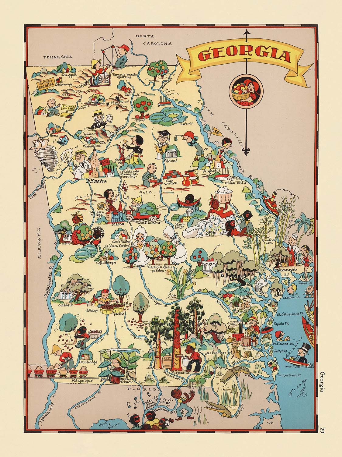
Adéntrese en el vibrante mundo de la Georgia de la década de 1930 con el exquisito mapa ilustrado titulado simplemente "Georgia", creado por la célebre Ruth Taylor White en 1935. Esta obra maestra pictórica es mucho más que un mero registro geográfico: es una alegre celebración del carácter único del estado, representada con un estilo a la vez caprichoso y meticulosamente detallado. Cada centímetro del mapa rebosa de color y energía, e invita al espectador a experimentar Georgia tal como se imaginaba durante un período marcado tanto por las dificultades como por la esperanza. La artística y lúdica composición del mapa, junto con sus atractivas viñetas, evoca una sensación de nostalgia, convirtiéndolo en una cautivadora pieza de conversación para coleccionistas y conocedores por igual.
Ruth Taylor White, reconocida por su trabajo en el género del mapa pictórico, aporta su inconfundible estilo a esta representación de Georgia. Junto con su marido, Frank Taylor White, creó una serie de atlas caricaturescos que redefinieron la manera en que los estadounidenses percibían su propia geografía. Su enfoque es reconocible al instante: tonos intensos y saturados, vivaces caricaturas y un suave humor que invita a la exploración. Cada límite de condado está trazado con precisión, mientras que las ilustraciones—que representan desde bulliciosos barcos de vapor hasta apacibles bosques de pinos—captan la esencia de los diversos paisajes y del legendario pasado del estado.
El mapa es un tapiz temático que entrelaza el patrimonio agrícola de Georgia con escenas de la vida cotidiana y la industria. Los campos de algodón y los huertos de melocotoneros se extienden por el campo, mientras que las imágenes de ganado y trabajadores rurales reflejan el ritmo de la tierra. Los barcos de vapor surcan los ríos ilustrados, recordando el papel vital de las vías fluviales en el desarrollo del estado. La costa está representada con gran elegancia, aludiendo a las tradiciones marítimas y a la importancia de la fachada atlántica de Georgia. A través de estas imágenes, el mapa narra la historia de un estado moldeado por sus recursos naturales y por la perseverancia de su gente.
Lo que distingue verdaderamente a este mapa es su capacidad para combinar el contexto histórico con la expresión artística. Creado durante la Gran Depresión, ofrece una visión del optimismo y la resiliencia de la época, aun cuando caricaturiza con delicadeza las costumbres y vestimentas de los habitantes de Georgia. Las escenas lúdicas del mapa—la pesca, la caza y las festividades rurales—se equilibran con una atención respetuosa a las realidades demográficas y económicas del estado. Aunque no señala específicamente parques nacionales ni monumentos históricos, las ilustraciones del mapa evocan la belleza natural y la riqueza cultural que definen a Georgia.
Anclando el mapa se encuentran las ciudades y localidades más prominentes del estado, cada una cuidadosamente situada entre el paisaje ilustrado. Atlanta, Savannah, Augusta y Macon destacan como centros de comercio y cultura, mientras que localidades más pequeñas como Albany, Athens y Brunswick se representan con igual encanto. La meticulosa atención del mapa tanto a la geografía como a la imaginación garantiza que cada espectador se vea atraído a un delicioso viaje por Georgia, testimonio del legado perdurable de Ruth Taylor White como una de las grandes cartógrafas pictóricas de Estados Unidos.
Ciudades y localidades en este mapa
- Atlanta
- Augusta
- Savannah
- Macon
- Columbus
- Albany
- Athens
- Rome
- Brunswick
- Valdosta
Características destacadas y lugares de interés
- Los límites y nombres de los condados están claramente marcados en todo el estado.
- Ilustraciones de actividades agrícolas, como la recogida del algodón y la cosecha de melocotones, que representan el patrimonio agrícola de Georgia.
- Representaciones caricaturescas de personas con atuendo tradicional del sur.
- Dibujos de barcos de vapor y escenas fluviales, que destacan la historia del transporte fluvial de Georgia.
- Representación pictórica de bosques de pinos y actividades madereras.
- Ilustraciones de ganado y animales de granja, que enfatizan la vida rural.
- Imágenes de trabajadores afroamericanos, que reflejan la demografía y el contexto social de la época.
- Representación de la costa y las actividades marítimas a lo largo de la costa atlántica.
- Representaciones caricaturescas de actividades recreativas, como la pesca y la caza.
- Representaciones artísticas de los paisajes naturales de Georgia, incluidas colinas y bosques.
Contexto histórico y de diseño
- Cartógrafa original: Ruth Taylor White, célebre por sus mapas pictóricos en la década de 1930.
- Fecha de creación: 1935.
- Parte de una serie de atlas caricaturescos que representan Estados Unidos, conocida por su distintivo estilo pictórico y temático.
- Presenta ilustraciones vibrantes, coloridas y caprichosas, con representaciones caricaturescas de personas, actividades y lugares emblemáticos.
- Diseñado para ser a la vez entretenido e informativo, capturando el espíritu y el encanto de Georgia mediante imágenes lúdicas.
- Creado durante la era de la Gran Depresión, el mapa refleja tanto el optimismo como la cultura popular de la época.
- Destaca por su combinación de geografía y arte, lo que lo convierte en una pieza de colección y también educativa.
Por favor, compruebe de nuevo las imágenes para asegurarse de que en este mapa aparezca una ciudad o lugar concreto. También puede ponerse en contacto con nosotros y pedirnos que revisemos el mapa por usted.
Este mapa luce estupendo en cualquier tamaño, pero siempre recomiendo optar por un tamaño mayor si dispone de espacio. Así podrá apreciar fácilmente todos los detalles.
Este mapa luce increíble en tamaños de hasta 50in (125cm). Si está buscando un mapa más grande, por favor póngase en contacto.
El modelo en las imágenes del anuncio sostiene la versión de 18x24in (45x60cm) de este mapa.
La quinta imagen del anuncio muestra un ejemplo de mi servicio de personalización de mapas.
Si busca algo ligeramente diferente, consulte mi colección de los mejores mapas antiguos para ver si algo más le llama la atención.
Por favor, contácteme para comprobar si en este mapa aparece una ubicación, un punto de referencia o una característica concretos.
Sería un regalo maravilloso de cumpleaños, Navidad, Día del Padre, despedida de trabajo, aniversario o inauguración de casa para alguien de las zonas cubiertas por este mapa.
Este mapa está disponible como impresión giclée sobre papel mate de archivo libre de ácido, o puede adquirirse enmarcado. El marco es un bonito y sencillo marco negro que se adapta a la mayoría de las estéticas. Por favor, póngase en contacto si desea un color o material de marco diferente. Nuestros marcos llevan un acristalamiento de acrílico de grado museo, ultrapuro (perspex/acrylite), que es considerablemente menos reflectante que el vidrio, más seguro y llegará siempre en perfectas condiciones.
This map is also available as a float framed canvas, sometimes known as a shadow gap framed canvas or canvas floater. The map is printed on artist's cotton canvas and then stretched over a handmade box frame. We then "float" the canvas inside a wooden frame, which is available in a range of colours (black, dark brown, oak, antique gold and white). This is a wonderful way to present a map without glazing in front. See some examples of float framed canvas maps and explore the differences between my different finishes.
For something truly unique, this map is also available in "Unique 3D", our trademarked process that dramatically transforms the map so that it has a wonderful sense of depth. We combine the original map with detailed topography and elevation data, so that mountains and the terrain really "pop". For more info and examples of 3D maps, check my Unique 3D page.
Many of our maps and art prints are chosen as thoughtful gifts for homes, offices, studies and meaningful places.
Choose a framed option for the easiest ready-to-hang gift, or choose an unframed print if the recipient may prefer to select their own frame.
We make orders locally in 23 countries around the world, so gifts can often be produced close to the recipient. This helps them arrive faster, travel more safely, and avoid customs or import duty surprises.
- We can deliver directly to the recipient
- Framed pieces arrive ready to hang
- Unframed prints are carefully packed in a strong protective tube
- Almost every order is made locally, for faster, safer gifting
- 90-day returns give the recipient time to decide
If you are not sure what to choose, please contact us. We can help you pick the right map, size, finish or delivery option.
Para la mayoría de los pedidos, el tiempo de entrega es de aproximadamente 3 días laborables. Los productos personalizados y a medida tardan más, ya que tengo que hacer la personalización y enviártelo para su aprobación, lo cual suele tardar 1 o 2 días.
Tenga en cuenta que los pedidos enmarcados muy grandes suelen tardar más en fabricarse y entregarse.
Si necesitas que tu pedido llegue para una fecha determinada, por favor contáctame antes de hacer el pedido para que podamos encontrar la mejor manera de asegurarnos de que recibas tu pedido a tiempo.
Imprimo y enmarco mapas y obras de arte en 23 países alrededor del mundo. Esto significa que tu pedido se fabricará localmente, lo que reduce el tiempo de entrega y asegura que no se dañe durante el envío. Nunca pagarás aranceles de aduana o impuestos de importación, y pondremos menos CO2 en el aire.
Todos mis mapas y impresiones artísticas están bien empaquetados y enviados en un tubo resistente si no están enmarcados, o rodeados de espuma si están enmarcados.
Intento enviar todos los pedidos dentro de 1 o 2 días después de recibir tu pedido, aunque algunos productos (como mascarillas, tazas y bolsas de tela) pueden tardar más en fabricarse.
Si seleccionas Entrega Exprés al finalizar la compra, priorizaremos tu pedido y lo enviaremos por mensajería de 1 día (Fedex, DHL, UPS, Parcelforce).
La entrega al día siguiente también está disponible en algunos países (EE. UU., Reino Unido, Singapur, EAU), pero por favor intenta hacer tu pedido temprano en el día para que podamos enviarlo a tiempo.
Mi marco estándar es un marco de madera de fresno negro estilo galería. Es simple y tiene un aspecto bastante moderno. Mi marco estándar tiene alrededor de 20 mm (0.8 in) de ancho.
Utilizo acrílico super claro (perspex/acrylite) para el vidrio del marco. Es más ligero y seguro que el vidrio, y se ve mejor, ya que la reflectividad es menor.
Seis colores de marco estándar están disponibles de forma gratuita (negro, marrón oscuro, gris oscuro, roble, blanco y oro antiguo).El enmarcado y montaje/matizado personalizado está disponible si buscas algo diferente.
La mayoría de los mapas, arte e ilustraciones también están disponibles como un lienzo enmarcado. Utilizamos lienzo de algodón mate (no brillante), lo estiramos sobre un marco de madera de caja de origen sostenible, y luego 'flotamos' la pieza dentro de un marco de madera. El resultado final es bastante hermoso, y no hay cristal que se interponga.
Todos los marcos se proporcionan "listos para colgar", con una cuerda o soportes en la parte posterior. Los marcos muy grandes tendrán placas de colgar de alta resistencia y/o un listón de montaje. Si tienes alguna pregunta, por favor ponte en contacto.
Mira algunos ejemplos de mis mapas enmarcados y mapas en lienzo enmarcados.
Alternativamente, también puedo proporcionar mapas antiguos y obras de arte en lienzo, tablero de espuma, papel de algodón y otros materiales.
Si deseas enmarcar tu mapa o obra de arte tú mismo, por favor lee mi guía de tamaños primero.
Mis mapas son reproducciones de mapas originales de altísima calidad.
Obtengo mapas originales y raros de bibliotecas, casas de subastas y colecciones privadas de todo el mundo, los restauro en mi taller de Londres y luego uso tintas e impresoras giclée especializadas para crear hermosos mapas que lucen incluso mejor que el original.
Mis mapas están impresos en papel de archivo mate (no brillante) sin ácido que se siente de muy alta calidad y casi como una tarjeta. En términos técnicos, el peso/grosor del papel es de 10 mil/200 g/m². Es perfecto para enmarcar.
Imprimo con tintas pigmentadas Epson ultrachrome giclée UV resistentes a la decoloración, algunas de las mejores tintas que puedes encontrar.
yo también puedo hacer mapas sobre lienzo, trapo de algodón y otros materiales exóticos.
Obtenga más información sobre The Unique Maps Co..
Personalización de mapas
Si está buscando el regalo perfecto de aniversario o inauguración de la casa, puedo personalizar su mapa para hacerlo verdaderamente único. Por ejemplo, puedo agregar un mensaje corto, resaltar una ubicación importante o agregar el escudo de armas de su familia.
Las opciones son casi infinitas. Por favor mira mi página de personalización de mapas para ver algunos maravillosos ejemplos de lo que es posible.
Para pedir un mapa personalizado, seleccione "personalizar su mapa" antes de agregarlo a su carrito.
Ponerse en contacto si buscas personalizaciones y personalizaciones más complejas.
Envejecimiento del mapa
A lo largo de los años, los clientes me han preguntado cientos de veces si podían comprar un mapa que se viera uniforme. más viejo.
Bueno, ahora puedes hacerlo seleccionando Envejecido antes de agregar un mapa a tu carrito.
Todas las fotografías de productos que ve en esta página muestran el mapa en su forma original. Así es como se ve el mapa hoy.
Si selecciona Envejecido, envejeceré su mapa a mano, usando un proceso especial y único desarrollado a través de años de estudiar mapas antiguos, hablar con investigadores para comprender la química del envejecimiento del papel y, por supuesto... ¡mucha práctica!
Si no estás seguro, quédate con el color original del mapa. Si quieres algo un poco más oscuro y más viejo buscando, opte por Envejecido.
Si no estás satisfecho con tu pedido por cualquier motivo, contáctame para un reembolso sin complicaciones. Por favor, consulta nuestra política de devoluciones y reembolsos para más información.
Estoy muy seguro de que te gustará tu mapa o impresión artística restaurada. He estado haciendo esto desde 1984. Soy un vendedor de 5 estrellas en Etsy. He vendido decenas de miles de mapas e impresiones artísticas y tengo más de 5,000 opiniones reales de 5 estrellas.
Utilizo un proceso único para restaurar mapas y obras de arte que consume mucho tiempo y mano de obra. Buscar los mapas e ilustraciones originales puede llevar meses. Utilizo tecnología de última generación y extremadamente cara para escanear y restaurarlos. Como resultado, garantizo que mis mapas e impresiones artísticas son superiores a los demás - por eso puedo ofrecer un reembolso sin complicaciones.
Casi todos mis mapas e impresiones artísticas se ven increíbles en tamaños grandes (200cm, 6.5ft+) y también puedo enmarcarlos y entregártelos a través de un servicio de mensajería especial para tamaños grandes. Contáctame para discutir tus necesidades específicas.
Or try searching for something!


