


Mapa pictórico del Caribe y Centroamérica de Ruth Taylor White, 1935: Canal de Panamá, Puerto Rico, La Habana, San Juan, Santo Domingo
La oferta del coleccionista
Elija dos obras elegibles y obtenga un 20 % de descuento en ambas. Elija tres y la de menor precio será gratuita, con un ahorro máximo del 33 %.
Combine y mezcle mapas estándar elegibles y reproducciones de bellas artes. No se requiere código; la oferta se aplica automáticamente al finalizar la compra.
Se incluyen las configuraciones estándar hechas por encargo. Quedan excluidos los tamaños a medida, los diseños personalizados y los trabajos por encargo.
¿Necesita entrega en diferentes direcciones? Contáctenos antes de realizar el pedido.La oferta del coleccionista
Elija dos obras elegibles y obtenga un 20 % de descuento en ambas. Elija tres y la de menor precio será gratuita, con un ahorro máximo del 33 %.
Combine y mezcle mapas estándar elegibles y reproducciones de bellas artes. No se requiere código; la oferta se aplica automáticamente al finalizar la compra.
Se incluyen las configuraciones estándar hechas por encargo. Quedan excluidos los tamaños a medida, los diseños personalizados y los trabajos por encargo.
¿Necesita entrega en diferentes direcciones? Contáctenos antes de realizar el pedido.
Restaurado a partir del mapa original de 1935 e impreso en calidad museo. Leer la historia detrás de este mapa
Choose your size
Choose your finish


(Más información)
Mensaje de regalo y acabado personalizado

Si deseas agregar un mensaje de regalo, o un acabado (rompecabezas, tablero de aluminio, etc.) que no esté disponible aquí, por favor solicítalo en la "nota del pedido" cuando realices la compra.
Cada pedido es hecho a medida, así que si necesitas que el tamaño se ajuste ligeramente, o que se imprima en un material inusual, háznoslo saber. Hemos realizado miles de pedidos personalizados a lo largo de los años, así que hay (casi) nada que no podamos gestionar.
También puedes contactarnos antes de hacer tu pedido, ¡si lo prefieres!

- Hecho localmente. Entrega segura
- Sin aranceles ni cargos ocultos
- ¿Necesitas ayuda? Llámanos o mensaje por WhatsApp
Own a piece of history
8,000+ five-star reviews


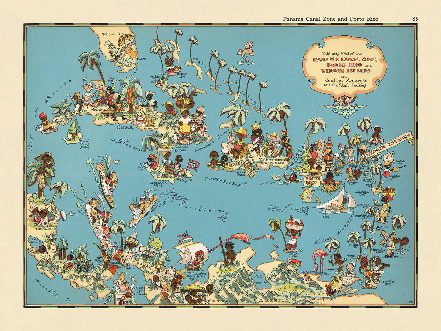
Adéntrese en un vibrante capítulo del arte cartográfico del siglo XX con “Panama Canal Zone, and Puerto Rico,” una creación original de...
Seguir leyendoAdéntrese en un vibrante capítulo del arte cartográfico del siglo XX con “Panama Canal Zone, and Puerto Rico,” una creación original de 1935 de la célebre Ruth Taylor White. Este mapa se erige como testimonio del espíritu lúdico pero informativo que definió las obras pictóricas de White, capturando el corazón del Caribe y Centroamérica con un aire caprichoso. El propio título del mapa ya sugiere su doble enfoque: la estratégicamente vital Zona del Canal de Panamá y la culturalmente rica isla de Puerto Rico. Sin embargo, su alcance va mucho más allá, abarcando la cuenca caribeña en su conjunto, desde Cuba y las Islas Vírgenes hasta las costas septentrionales de Colombia y Venezuela, convirtiéndolo en un panorama de una región en cambio y transformación.
Ruth Taylor White, célebre por sus mapas atractivos y coloridos, infundió a su obra un encanto distintivo que la diferenció de sus contemporáneos. Colaborando a menudo con su esposo, Frank Taylor, produjo una serie de atlas pictóricos que combinaban precisión geográfica con una sensación de asombro y deleite. Sus mapas no eran meras herramientas de navegación, sino experiencias inmersivas, diseñadas para educar y entretener. Esta pieza de 1935 no es una excepción, rebosante de ilustraciones de época y animadas viñetas que reflejan tanto la diversidad como los estereotipos de la era. El arte de White invita al espectador a explorar, descubrir y, sobre todo, a disfrutar del mundo que retrató con tanto cariño.
El diseño del mapa es una clase magistral de cartografía temática, que combina colores intensos e ilustraciones lúdicas para destacar el carácter singular de cada región. El propio Canal de Panamá ocupa un lugar de honor, y su maravilla de la ingeniería se representa con claridad y reverencia, mientras que la Zona del Canal circundante se muestra como un bullicioso centro de actividad internacional. Puerto Rico también está representado con cariño, con sus paisajes tropicales y su vibrante cultura cobrando vida gracias a la hábil mano de White. La inclusión de Cuba, Haití, la República Dominicana y las Antillas Menores enriquece aún más la composición, ofreciendo una visión integral de las historias y geografías interconectadas del Caribe.
Más allá de su alcance geográfico, el mapa está adornado con encantadoras ilustraciones que evocan el espíritu de la década de 1930. Escenas estereotipadas pero evocadoras, como la cosecha de caña de azúcar, la recolección de frutas tropicales y el comercio marítimo, salpican el paisaje, ofreciendo una narrativa visual de la vida económica y cultural de la región. Ciudades principales como Ciudad de Panamá, San Juan, La Habana y Santo Domingo aparecen destacadas, y su importancia se subraya mediante la cuidadosa atención al detalle de White. Los mares circundantes —el Caribe, el Atlántico y el Pacífico— están elegantemente rotulados, enmarcando el mapa en un contexto de relevancia y conexión global.
Históricamente, este mapa es un artefacto fascinante, que captura un momento en que el Canal de Panamá alcanzaba el cénit de su importancia geopolítica y en que el interés estadounidense por el Caribe era tanto estratégico como cultural. El estilo lúdico, de aire caricaturesco, oculta una narrativa más profunda de exploración, comercio e intercambio intercultural. Como obra de arte y documento de su tiempo, “Panama Canal Zone, and Puerto Rico” ofrece a coleccionistas y aficionados una rara visión del mundo tal como se veía —e imaginaba— hace casi un siglo, convirtiéndolo en una incorporación verdaderamente excepcional a cualquier colección de mapas históricos.
Ciudades y poblaciones en este mapa
- Ciudad de Panamá (Panamá)
- San Juan
- La Habana
- Santo Domingo
- Port-au-Prince
- Caracas
- Barranquilla
Características destacadas y lugares de interés
- El Canal de Panamá está ilustrado y rotulado de forma prominente.
- La Zona del Canal de Panamá está claramente resaltada.
- La isla de Puerto Rico está rotulada e ilustrada.
- Cuba está rotulada y representada.
- Haití y la República Dominicana (que comparten la isla de La Española) están rotuladas.
- Las Islas Vírgenes están rotuladas.
- Las Antillas Menores están rotuladas como grupo.
- Nicaragua, Costa Rica y Panamá están rotuladas.
- El norte de Colombia y el norte de Venezuela están mostrados y rotulados.
- El Mar Caribe está rotulado.
- El Océano Atlántico está rotulado.
- El Océano Pacífico está rotulado.
- Vinetas ilustrativas representan la vida local, la agricultura y la industria, como la cosecha de caña de azúcar, las frutas tropicales y el transporte marítimo.
- Se muestran figuras de caricatura estereotipadas y propias de la época que representan a la población local y sus actividades.
Contexto histórico y de diseño
- Nombre del mapa: Canal de Panamá, Zona del Canal, y Puerto Rico
- Cartógrafa: Ruth Taylor White
- Fecha de creación: 1935
- Forma parte de un atlas caricaturesco de Estados Unidos, conocido por su estilo caprichoso y pictórico.
- Presenta ilustraciones coloridas, de estilo caricaturesco, y representaciones lúdicas, características de los mapas de Ruth Taylor White de la década de 1930.
- Resalta escenas estereotipadas y propias de la época, reflejando narrativas culturales y sociales de la década de 1930.
- Sirve como una pieza singular que muestra las perspectivas y actitudes de la época, así como la importancia de la Zona del Canal de Panamá y Puerto Rico para Estados Unidos en aquel momento.
- El mapa es a la vez entretenido e informativo, combinando rasgos geográficos con un arte caprichoso para evocar nostalgia y encanto.
Por favor, revise detenidamente las imágenes para asegurarse de que se muestra en este mapa una ciudad o lugar específico. También puede ponerse en contacto con nosotros y pedirnos que revisemos el mapa por usted.
Este mapa luce великолепoso en cualquier tamaño, pero siempre recomiendo optar por un tamaño mayor si dispone de espacio. De ese modo, podrá distinguir fácilmente todos los detalles.
Este mapa se ve increíble en tamaños de hasta 50in (125cm). Si busca un mapa más grande, por favor póngase en contacto.
El modelo en las imágenes del anuncio está sosteniendo la versión de 18x24in (45x60cm) de este mapa.
La quinta imagen del anuncio muestra un ejemplo de mi servicio de personalización de mapas.
Si busca algo ligeramente diferente, eche un vistazo a mi colección de los mejores mapas antiguos para ver si algo más llama su atención.
Por favor, contácteme para comprobar si una cierta ubicación, punto de referencia o característica aparece en este mapa.
Esto sería un maravilloso regalo de cumpleaños, Navidad, Día del Padre, despedida del trabajo, aniversario o inauguración del hogar para alguien de las zonas cubiertas por este mapa.
Este mapa está disponible como impresión giclée en papel mate de archivo libre de ácido, o puede adquirirlo enmarcado. El marco es un bonito y sencillo marco negro que combina con la mayoría de estilos decorativos. Por favor, póngase en contacto si desea un color o material de marco diferente. Mis marcos llevan acristalamiento de acrílico de calidad museística, ultratransparente (perspex/acrylite), que es considerablemente menos reflectante que el vidrio, más seguro y siempre llegará en perfectas condiciones.
This map is also available as a float framed canvas, sometimes known as a shadow gap framed canvas or canvas floater. The map is printed on artist's cotton canvas and then stretched over a handmade box frame. We then "float" the canvas inside a wooden frame, which is available in a range of colours (black, dark brown, oak, antique gold and white). This is a wonderful way to present a map without glazing in front. See some examples of float framed canvas maps and explore the differences between my different finishes.
For something truly unique, this map is also available in "Unique 3D", our trademarked process that dramatically transforms the map so that it has a wonderful sense of depth. We combine the original map with detailed topography and elevation data, so that mountains and the terrain really "pop". For more info and examples of 3D maps, check my Unique 3D page.
Adéntrese en un vibrante capítulo del arte cartográfico del siglo XX con “Panama Canal Zone, and Puerto Rico,” una creación original de 1935 de la célebre Ruth Taylor White. Este mapa se erige como testimonio del espíritu lúdico pero informativo que definió las obras pictóricas de White, capturando el corazón del Caribe y Centroamérica con un aire caprichoso. El propio título del mapa ya sugiere su doble enfoque: la estratégicamente vital Zona del Canal de Panamá y la culturalmente rica isla de Puerto Rico. Sin embargo, su alcance va mucho más allá, abarcando la cuenca caribeña en su conjunto, desde Cuba y las Islas Vírgenes hasta las costas septentrionales de Colombia y Venezuela, convirtiéndolo en un panorama de una región en cambio y transformación.
Ruth Taylor White, célebre por sus mapas atractivos y coloridos, infundió a su obra un encanto distintivo que la diferenció de sus contemporáneos. Colaborando a menudo con su esposo, Frank Taylor, produjo una serie de atlas pictóricos que combinaban precisión geográfica con una sensación de asombro y deleite. Sus mapas no eran meras herramientas de navegación, sino experiencias inmersivas, diseñadas para educar y entretener. Esta pieza de 1935 no es una excepción, rebosante de ilustraciones de época y animadas viñetas que reflejan tanto la diversidad como los estereotipos de la era. El arte de White invita al espectador a explorar, descubrir y, sobre todo, a disfrutar del mundo que retrató con tanto cariño.
El diseño del mapa es una clase magistral de cartografía temática, que combina colores intensos e ilustraciones lúdicas para destacar el carácter singular de cada región. El propio Canal de Panamá ocupa un lugar de honor, y su maravilla de la ingeniería se representa con claridad y reverencia, mientras que la Zona del Canal circundante se muestra como un bullicioso centro de actividad internacional. Puerto Rico también está representado con cariño, con sus paisajes tropicales y su vibrante cultura cobrando vida gracias a la hábil mano de White. La inclusión de Cuba, Haití, la República Dominicana y las Antillas Menores enriquece aún más la composición, ofreciendo una visión integral de las historias y geografías interconectadas del Caribe.
Más allá de su alcance geográfico, el mapa está adornado con encantadoras ilustraciones que evocan el espíritu de la década de 1930. Escenas estereotipadas pero evocadoras, como la cosecha de caña de azúcar, la recolección de frutas tropicales y el comercio marítimo, salpican el paisaje, ofreciendo una narrativa visual de la vida económica y cultural de la región. Ciudades principales como Ciudad de Panamá, San Juan, La Habana y Santo Domingo aparecen destacadas, y su importancia se subraya mediante la cuidadosa atención al detalle de White. Los mares circundantes —el Caribe, el Atlántico y el Pacífico— están elegantemente rotulados, enmarcando el mapa en un contexto de relevancia y conexión global.
Históricamente, este mapa es un artefacto fascinante, que captura un momento en que el Canal de Panamá alcanzaba el cénit de su importancia geopolítica y en que el interés estadounidense por el Caribe era tanto estratégico como cultural. El estilo lúdico, de aire caricaturesco, oculta una narrativa más profunda de exploración, comercio e intercambio intercultural. Como obra de arte y documento de su tiempo, “Panama Canal Zone, and Puerto Rico” ofrece a coleccionistas y aficionados una rara visión del mundo tal como se veía —e imaginaba— hace casi un siglo, convirtiéndolo en una incorporación verdaderamente excepcional a cualquier colección de mapas históricos.
Ciudades y poblaciones en este mapa
- Ciudad de Panamá (Panamá)
- San Juan
- La Habana
- Santo Domingo
- Port-au-Prince
- Caracas
- Barranquilla
Características destacadas y lugares de interés
- El Canal de Panamá está ilustrado y rotulado de forma prominente.
- La Zona del Canal de Panamá está claramente resaltada.
- La isla de Puerto Rico está rotulada e ilustrada.
- Cuba está rotulada y representada.
- Haití y la República Dominicana (que comparten la isla de La Española) están rotuladas.
- Las Islas Vírgenes están rotuladas.
- Las Antillas Menores están rotuladas como grupo.
- Nicaragua, Costa Rica y Panamá están rotuladas.
- El norte de Colombia y el norte de Venezuela están mostrados y rotulados.
- El Mar Caribe está rotulado.
- El Océano Atlántico está rotulado.
- El Océano Pacífico está rotulado.
- Vinetas ilustrativas representan la vida local, la agricultura y la industria, como la cosecha de caña de azúcar, las frutas tropicales y el transporte marítimo.
- Se muestran figuras de caricatura estereotipadas y propias de la época que representan a la población local y sus actividades.
Contexto histórico y de diseño
- Nombre del mapa: Canal de Panamá, Zona del Canal, y Puerto Rico
- Cartógrafa: Ruth Taylor White
- Fecha de creación: 1935
- Forma parte de un atlas caricaturesco de Estados Unidos, conocido por su estilo caprichoso y pictórico.
- Presenta ilustraciones coloridas, de estilo caricaturesco, y representaciones lúdicas, características de los mapas de Ruth Taylor White de la década de 1930.
- Resalta escenas estereotipadas y propias de la época, reflejando narrativas culturales y sociales de la década de 1930.
- Sirve como una pieza singular que muestra las perspectivas y actitudes de la época, así como la importancia de la Zona del Canal de Panamá y Puerto Rico para Estados Unidos en aquel momento.
- El mapa es a la vez entretenido e informativo, combinando rasgos geográficos con un arte caprichoso para evocar nostalgia y encanto.
Por favor, revise detenidamente las imágenes para asegurarse de que se muestra en este mapa una ciudad o lugar específico. También puede ponerse en contacto con nosotros y pedirnos que revisemos el mapa por usted.
Este mapa luce великолепoso en cualquier tamaño, pero siempre recomiendo optar por un tamaño mayor si dispone de espacio. De ese modo, podrá distinguir fácilmente todos los detalles.
Este mapa se ve increíble en tamaños de hasta 50in (125cm). Si busca un mapa más grande, por favor póngase en contacto.
El modelo en las imágenes del anuncio está sosteniendo la versión de 18x24in (45x60cm) de este mapa.
La quinta imagen del anuncio muestra un ejemplo de mi servicio de personalización de mapas.
Si busca algo ligeramente diferente, eche un vistazo a mi colección de los mejores mapas antiguos para ver si algo más llama su atención.
Por favor, contácteme para comprobar si una cierta ubicación, punto de referencia o característica aparece en este mapa.
Esto sería un maravilloso regalo de cumpleaños, Navidad, Día del Padre, despedida del trabajo, aniversario o inauguración del hogar para alguien de las zonas cubiertas por este mapa.
Este mapa está disponible como impresión giclée en papel mate de archivo libre de ácido, o puede adquirirlo enmarcado. El marco es un bonito y sencillo marco negro que combina con la mayoría de estilos decorativos. Por favor, póngase en contacto si desea un color o material de marco diferente. Mis marcos llevan acristalamiento de acrílico de calidad museística, ultratransparente (perspex/acrylite), que es considerablemente menos reflectante que el vidrio, más seguro y siempre llegará en perfectas condiciones.
This map is also available as a float framed canvas, sometimes known as a shadow gap framed canvas or canvas floater. The map is printed on artist's cotton canvas and then stretched over a handmade box frame. We then "float" the canvas inside a wooden frame, which is available in a range of colours (black, dark brown, oak, antique gold and white). This is a wonderful way to present a map without glazing in front. See some examples of float framed canvas maps and explore the differences between my different finishes.
For something truly unique, this map is also available in "Unique 3D", our trademarked process that dramatically transforms the map so that it has a wonderful sense of depth. We combine the original map with detailed topography and elevation data, so that mountains and the terrain really "pop". For more info and examples of 3D maps, check my Unique 3D page.
Many of our maps and art prints are chosen as thoughtful gifts for homes, offices, studies and meaningful places.
Choose a framed option for the easiest ready-to-hang gift, or choose an unframed print if the recipient may prefer to select their own frame.
We make orders locally in 23 countries around the world, so gifts can often be produced close to the recipient. This helps them arrive faster, travel more safely, and avoid customs or import duty surprises.
- We can deliver directly to the recipient
- Framed pieces arrive ready to hang
- Unframed prints are carefully packed in a strong protective tube
- Almost every order is made locally, for faster, safer gifting
- 90-day returns give the recipient time to decide
If you are not sure what to choose, please contact us. We can help you pick the right map, size, finish or delivery option.
Para la mayoría de los pedidos, el tiempo de entrega es de aproximadamente 3 días laborables. Los productos personalizados y a medida tardan más, ya que tengo que hacer la personalización y enviártelo para su aprobación, lo cual suele tardar 1 o 2 días.
Tenga en cuenta que los pedidos enmarcados muy grandes suelen tardar más en fabricarse y entregarse.
Si necesitas que tu pedido llegue para una fecha determinada, por favor contáctame antes de hacer el pedido para que podamos encontrar la mejor manera de asegurarnos de que recibas tu pedido a tiempo.
Imprimo y enmarco mapas y obras de arte en 23 países alrededor del mundo. Esto significa que tu pedido se fabricará localmente, lo que reduce el tiempo de entrega y asegura que no se dañe durante el envío. Nunca pagarás aranceles de aduana o impuestos de importación, y pondremos menos CO2 en el aire.
Todos mis mapas y impresiones artísticas están bien empaquetados y enviados en un tubo resistente si no están enmarcados, o rodeados de espuma si están enmarcados.
Intento enviar todos los pedidos dentro de 1 o 2 días después de recibir tu pedido, aunque algunos productos (como mascarillas, tazas y bolsas de tela) pueden tardar más en fabricarse.
Si seleccionas Entrega Exprés al finalizar la compra, priorizaremos tu pedido y lo enviaremos por mensajería de 1 día (Fedex, DHL, UPS, Parcelforce).
La entrega al día siguiente también está disponible en algunos países (EE. UU., Reino Unido, Singapur, EAU), pero por favor intenta hacer tu pedido temprano en el día para que podamos enviarlo a tiempo.
Mi marco estándar es un marco de madera de fresno negro estilo galería. Es simple y tiene un aspecto bastante moderno. Mi marco estándar tiene alrededor de 20 mm (0.8 in) de ancho.
Utilizo acrílico super claro (perspex/acrylite) para el vidrio del marco. Es más ligero y seguro que el vidrio, y se ve mejor, ya que la reflectividad es menor.
Seis colores de marco estándar están disponibles de forma gratuita (negro, marrón oscuro, gris oscuro, roble, blanco y oro antiguo).El enmarcado y montaje/matizado personalizado está disponible si buscas algo diferente.
La mayoría de los mapas, arte e ilustraciones también están disponibles como un lienzo enmarcado. Utilizamos lienzo de algodón mate (no brillante), lo estiramos sobre un marco de madera de caja de origen sostenible, y luego 'flotamos' la pieza dentro de un marco de madera. El resultado final es bastante hermoso, y no hay cristal que se interponga.
Todos los marcos se proporcionan "listos para colgar", con una cuerda o soportes en la parte posterior. Los marcos muy grandes tendrán placas de colgar de alta resistencia y/o un listón de montaje. Si tienes alguna pregunta, por favor ponte en contacto.
Mira algunos ejemplos de mis mapas enmarcados y mapas en lienzo enmarcados.
Alternativamente, también puedo proporcionar mapas antiguos y obras de arte en lienzo, tablero de espuma, papel de algodón y otros materiales.
Si deseas enmarcar tu mapa o obra de arte tú mismo, por favor lee mi guía de tamaños primero.
Mis mapas son reproducciones de mapas originales de altísima calidad.
Obtengo mapas originales y raros de bibliotecas, casas de subastas y colecciones privadas de todo el mundo, los restauro en mi taller de Londres y luego uso tintas e impresoras giclée especializadas para crear hermosos mapas que lucen incluso mejor que el original.
Mis mapas están impresos en papel de archivo mate (no brillante) sin ácido que se siente de muy alta calidad y casi como una tarjeta. En términos técnicos, el peso/grosor del papel es de 10 mil/200 g/m². Es perfecto para enmarcar.
Imprimo con tintas pigmentadas Epson ultrachrome giclée UV resistentes a la decoloración, algunas de las mejores tintas que puedes encontrar.
yo también puedo hacer mapas sobre lienzo, trapo de algodón y otros materiales exóticos.
Obtenga más información sobre The Unique Maps Co..
Personalización de mapas
Si está buscando el regalo perfecto de aniversario o inauguración de la casa, puedo personalizar su mapa para hacerlo verdaderamente único. Por ejemplo, puedo agregar un mensaje corto, resaltar una ubicación importante o agregar el escudo de armas de su familia.
Las opciones son casi infinitas. Por favor mira mi página de personalización de mapas para ver algunos maravillosos ejemplos de lo que es posible.
Para pedir un mapa personalizado, seleccione "personalizar su mapa" antes de agregarlo a su carrito.
Ponerse en contacto si buscas personalizaciones y personalizaciones más complejas.
Envejecimiento del mapa
A lo largo de los años, los clientes me han preguntado cientos de veces si podían comprar un mapa que se viera uniforme. más viejo.
Bueno, ahora puedes hacerlo seleccionando Envejecido antes de agregar un mapa a tu carrito.
Todas las fotografías de productos que ve en esta página muestran el mapa en su forma original. Así es como se ve el mapa hoy.
Si selecciona Envejecido, envejeceré su mapa a mano, usando un proceso especial y único desarrollado a través de años de estudiar mapas antiguos, hablar con investigadores para comprender la química del envejecimiento del papel y, por supuesto... ¡mucha práctica!
Si no estás seguro, quédate con el color original del mapa. Si quieres algo un poco más oscuro y más viejo buscando, opte por Envejecido.
Si no estás satisfecho con tu pedido por cualquier motivo, contáctame para un reembolso sin complicaciones. Por favor, consulta nuestra política de devoluciones y reembolsos para más información.
Estoy muy seguro de que te gustará tu mapa o impresión artística restaurada. He estado haciendo esto desde 1984. Soy un vendedor de 5 estrellas en Etsy. He vendido decenas de miles de mapas e impresiones artísticas y tengo más de 5,000 opiniones reales de 5 estrellas.
Utilizo un proceso único para restaurar mapas y obras de arte que consume mucho tiempo y mano de obra. Buscar los mapas e ilustraciones originales puede llevar meses. Utilizo tecnología de última generación y extremadamente cara para escanear y restaurarlos. Como resultado, garantizo que mis mapas e impresiones artísticas son superiores a los demás - por eso puedo ofrecer un reembolso sin complicaciones.
Casi todos mis mapas e impresiones artísticas se ven increíbles en tamaños grandes (200cm, 6.5ft+) y también puedo enmarcarlos y entregártelos a través de un servicio de mensajería especial para tamaños grandes. Contáctame para discutir tus necesidades específicas.
Or try searching for something!


