


Mapa pictórico de New Hampshire de Ruth Taylor White, 1935: Manchester, Nashua, Concord, lagos, montañas
20% de descuento en 2 — 33% de descuento en 3
Añade dos artículos elegibles a tu carrito para recibir 20% de descuento. Añade un tercero y será complementario (equivalente a 33% de descuento al comprar tres).
No se necesita código — la oferta se aplica automáticamente al finalizar la compra.
Válido en todos los mapas estándar y impresiones de arte fino. Puedes mezclar y combinar cualquier diseño.
Si deseas enviar artículos a múltiples direcciones, por favor contáctanos antes de realizar tu pedido.
Las comisiones personalizadas y a medida están excluidas.
Contáctanos si tienes alguna pregunta

Choose your size
Choose your finish


(Más información)
Mensaje de regalo y acabado personalizado

Si deseas agregar un mensaje de regalo, o un acabado (rompecabezas, tablero de aluminio, etc.) que no esté disponible aquí, por favor solicítalo en la "nota del pedido" cuando realices la compra.
Cada pedido es hecho a medida, así que si necesitas que el tamaño se ajuste ligeramente, o que se imprima en un material inusual, háznoslo saber. Hemos realizado miles de pedidos personalizados a lo largo de los años, así que hay (casi) nada que no podamos gestionar.
También puedes contactarnos antes de hacer tu pedido, ¡si lo prefieres!

- Made locally for fast, safe delivery
- No import duty or hidden fees
- Need advice? Message us on WhatsApp
Own a piece of history
7,000+ 5 star reviews


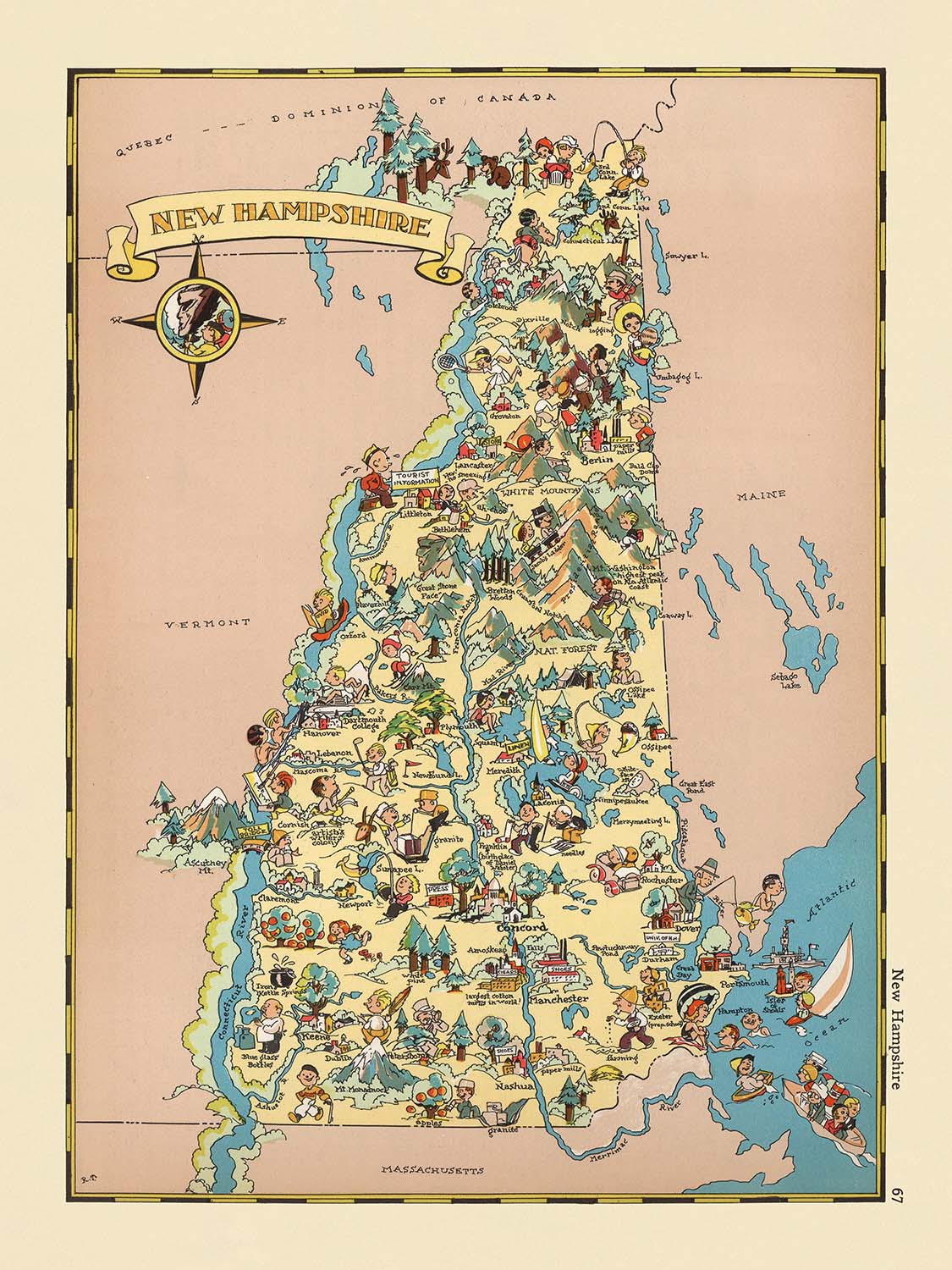
Adéntrese en el vibrante mundo del Nueva Inglaterra de los años 1930 con «New Hampshire», el título original de este cautivador mapa pictórico creado por Ruth Taylor White en 1935. Más que un simple registro cartográfico, este mapa es un animado tableau, rebosante de color y fantasía, que captura el espíritu y el carácter de New Hampshire tal como se imaginaba popularmente a comienzos del siglo XX. Cada región del estado cobra vida mediante una encantadora variedad de ilustraciones, ofreciendo una ventana a los paisajes, las industrias y los motivos culturales que definían la identidad de New Hampshire en aquella época.
Ruth Taylor White, la talentosa cartógrafa detrás de esta obra, era célebre por su estilo distintivo, que fusionaba arte y cartografía. Junto con su marido, Frank J. Taylor, produjo una aclamada serie de mapas pictóricos que combinaban ilustraciones lúdicas con una aguda observación histórica y cultural. Su obra destaca por su accesibilidad y encanto, haciendo de la geografía algo a la vez atractivo y educativo. El mapa «New Hampshire» es testimonio de su capacidad para condensar la esencia de un lugar, representando sus bosques, lagos y montañas con precisión y un inconfundible toque imaginativo.
El diseño de este mapa es sencillamente cautivador. En lugar de apoyarse en un detalle topográfico preciso, White opta por un enfoque temático, utilizando imágenes vibrantes para representar las ásperas montañas del estado, sus extensos bosques y sus resplandecientes lagos. Escenas de esquí, senderismo y pesca evocan la reputación del estado como refugio para los amantes del aire libre, mientras que viñetas agrícolas —con ganado y la producción de jarabe de arce— destacan los ritmos de la vida rural. Puentes cubiertos, iglesias coloniales y casas encantadoras salpican el paisaje, evocando la herencia arquitectónica y las tradiciones perdurables de Nueva Inglaterra.
Si bien el mapa prescinde de una anotación textual exhaustiva, sus ilustraciones dicen mucho sobre el contexto histórico y cultural del New Hampshire de los años 1930. Los límites del estado están claramente definidos y los condados se delimitan sutilmente, brindando una sensación de lugar sin abrumar al espectador con detalles. El mapa también presenta una constelación de pueblos y ciudades —Manchester, Nashua, Concord y muchos más—, cada uno representado con un toque singular que insinúa su carácter local y su relevancia. La ausencia de parques nacionales o grandes hitos no resta atractivo al mapa; al contrario, invita a los espectadores a apreciar la belleza natural del estado y sus vibrantes comunidades en conjunto.
En definitiva, este mapa es tanto un artefacto histórico como una obra de arte. Ofrece una rara mirada a cómo New Hampshire fue visto y celebrado en el imaginario estadounidense durante la década de 1930. Para coleccionistas, historiadores o cualquier amante de Nueva Inglaterra, «New Hampshire» de Ruth Taylor White es a la vez un deleite visual y un tesoro cultural: un evocador recuerdo de una época pasada, plasmado con calidez, ingenio e inconfundible estilo.
Ciudades y pueblos en este mapa
- Manchester
- Nashua
- Concord
- Derry
- Rochester
- Salem
- Dover
- Merrimack
- Londonderry
- Hudson
- Keene
- Portsmouth
- Bedford
- Goffstown
- Laconia
- Claremont
- Lebanon
- Somersworth
- Durham
- Exeter
- Hanover
- Windham
- Amherst
- Milford
- Raymond
- Hooksett
- Berlin
- Conway
- Franklin
- Newport
Características notables y lugares emblemáticos
- Ilustraciones coloridas de bosques y montañas, que representan el paisaje natural del estado
- Representaciones de personas realizando actividades al aire libre como esquí, senderismo y pesca
- Ilustraciones de escenas agrícolas y de labor rural, incluyendo ganado y cultivos
- Dibujos de lagos y ríos, que destacan las características hídricas de New Hampshire
- Imágenes de puentes cubiertos, un rasgo arquitectónico tradicional del estado
- Representaciones pictóricas de las industrias del estado, como la explotación forestal y la producción textil
- Interpretaciones artísticas de la fauna nativa de New Hampshire, como ciervos y peces
- Ilustraciones de la producción de jarabe de arce, una actividad tradicional de New Hampshire
- Motivos visuales de la cultura de Nueva Inglaterra, incluyendo casas y iglesias de estilo colonial
- El límite estatal está claramente delimitado, con los estados vecinos indicados tenuemente
- Los límites de los condados están marcados, pero no etiquetados con los nombres de los condados
Contexto histórico y de diseño
- Título original: New Hampshire (1935)
- Cartógrafa: Ruth Taylor White, conocida por su distintivo estilo cartográfico pictórico
- El mapa es un mapa temático y pictórico de condado o estado, parte de una serie mayor de mapas de los estados de EE. UU.
- El estilo artístico es altamente pictórico y de aspecto caricaturesco, centrado en la narración visual más que en la precisión geográfica
- El mapa ofrece una visión de cómo se percibía popularmente New Hampshire en la década de 1930, reflejando las actitudes sociales y culturales de la época
- Las ilustraciones sirven como una instantánea visual de la época, capturando tanto la belleza natural como las actividades económicas de New Hampshire
- El mapa destaca por su uso de colores vibrantes y figuras estilizadas para representar personas, animales y actividades
Por favor, vuelva a comprobar las imágenes para asegurarse de que se muestra una ciudad o lugar específico en este mapa. También puede ponerse en contacto con nosotros y pedirnos que revisemos el mapa por usted.
Este mapa luce magnífico en cualquier tamaño, pero siempre recomiendo elegir un tamaño mayor si dispone de espacio. De ese modo podrá apreciar fácilmente todos los detalles.
Este mapa luce increíble en tamaños de hasta 50in (125cm). Si busca un mapa más grande, por favor póngase en contacto.
El modelo en las imágenes del anuncio sostiene la versión de 18x24in (45x60cm) de este mapa.
La quinta imagen del anuncio muestra un ejemplo de mi servicio de personalización de mapas.
Si busca algo ligeramente diferente, eche un vistazo a mi colección de los mejores mapas antiguos para ver si algo más le llama la atención.
Por favor contácteme para comprobar si una determinada ubicación, lugar emblemático o característica aparece en este mapa.
Sería un regalo maravilloso de cumpleaños, Navidad, Día del Padre, despedida del trabajo, aniversario o inauguración de casa para alguien de las zonas cubiertas por este mapa.
Este mapa está disponible como impresión giclée en papel mate de archivo libre de ácido, o puede adquirirlo enmarcado. El marco es un bonito y sencillo marco negro que se adapta a la mayoría de estéticas. Póngase en contacto si desea un color o material de marco diferente. Mis marcos llevan un acristalamiento de acrílico de grado museístico de gran claridad (perspex/acrylite), que es considerablemente menos reflectante que el vidrio, más seguro y siempre llegará en perfecto estado.
This map is also available as a float framed canvas, sometimes known as a shadow gap framed canvas or canvas floater. The map is printed on artist's cotton canvas and then stretched over a handmade box frame. We then "float" the canvas inside a wooden frame, which is available in a range of colours (black, dark brown, oak, antique gold and white). This is a wonderful way to present a map without glazing in front. See some examples of float framed canvas maps and explore the differences between my different finishes.
For something truly unique, this map is also available in "Unique 3D", our trademarked process that dramatically transforms the map so that it has a wonderful sense of depth. We combine the original map with detailed topography and elevation data, so that mountains and the terrain really "pop". For more info and examples of 3D maps, check my Unique 3D page.
Many of our maps and art prints are chosen as thoughtful gifts for homes, offices, studies and meaningful places.
Choose a framed option for the easiest ready-to-hang gift, or choose an unframed print if the recipient may prefer to select their own frame.
We make orders locally in 23 countries around the world, so gifts can often be produced close to the recipient. This helps them arrive faster, travel more safely, and avoid customs or import duty surprises.
- We can deliver directly to the recipient
- Framed pieces arrive ready to hang
- Unframed prints are carefully packed in a strong protective tube
- Almost every order is made locally, for faster, safer gifting
- 90-day returns give the recipient time to decide
If you are not sure what to choose, please contact us. We can help you pick the right map, size, finish or delivery option.
Para la mayoría de los pedidos, el tiempo de entrega es de aproximadamente 3 días laborables. Los productos personalizados y a medida tardan más, ya que tengo que hacer la personalización y enviártelo para su aprobación, lo cual suele tardar 1 o 2 días.
Tenga en cuenta que los pedidos enmarcados muy grandes suelen tardar más en fabricarse y entregarse.
Si necesitas que tu pedido llegue para una fecha determinada, por favor contáctame antes de hacer el pedido para que podamos encontrar la mejor manera de asegurarnos de que recibas tu pedido a tiempo.
Imprimo y enmarco mapas y obras de arte en 23 países alrededor del mundo. Esto significa que tu pedido se fabricará localmente, lo que reduce el tiempo de entrega y asegura que no se dañe durante el envío. Nunca pagarás aranceles de aduana o impuestos de importación, y pondremos menos CO2 en el aire.
Todos mis mapas y impresiones artísticas están bien empaquetados y enviados en un tubo resistente si no están enmarcados, o rodeados de espuma si están enmarcados.
Intento enviar todos los pedidos dentro de 1 o 2 días después de recibir tu pedido, aunque algunos productos (como mascarillas, tazas y bolsas de tela) pueden tardar más en fabricarse.
Si seleccionas Entrega Exprés al finalizar la compra, priorizaremos tu pedido y lo enviaremos por mensajería de 1 día (Fedex, DHL, UPS, Parcelforce).
La entrega al día siguiente también está disponible en algunos países (EE. UU., Reino Unido, Singapur, EAU), pero por favor intenta hacer tu pedido temprano en el día para que podamos enviarlo a tiempo.
Mi marco estándar es un marco de madera de fresno negro estilo galería. Es simple y tiene un aspecto bastante moderno. Mi marco estándar tiene alrededor de 20 mm (0.8 in) de ancho.
Utilizo acrílico super claro (perspex/acrylite) para el vidrio del marco. Es más ligero y seguro que el vidrio, y se ve mejor, ya que la reflectividad es menor.
Seis colores de marco estándar están disponibles de forma gratuita (negro, marrón oscuro, gris oscuro, roble, blanco y oro antiguo).El enmarcado y montaje/matizado personalizado está disponible si buscas algo diferente.
La mayoría de los mapas, arte e ilustraciones también están disponibles como un lienzo enmarcado. Utilizamos lienzo de algodón mate (no brillante), lo estiramos sobre un marco de madera de caja de origen sostenible, y luego 'flotamos' la pieza dentro de un marco de madera. El resultado final es bastante hermoso, y no hay cristal que se interponga.
Todos los marcos se proporcionan "listos para colgar", con una cuerda o soportes en la parte posterior. Los marcos muy grandes tendrán placas de colgar de alta resistencia y/o un listón de montaje. Si tienes alguna pregunta, por favor ponte en contacto.
Mira algunos ejemplos de mis mapas enmarcados y mapas en lienzo enmarcados.
Alternativamente, también puedo proporcionar mapas antiguos y obras de arte en lienzo, tablero de espuma, papel de algodón y otros materiales.
Si deseas enmarcar tu mapa o obra de arte tú mismo, por favor lee mi guía de tamaños primero.
Mis mapas son reproducciones de mapas originales de altísima calidad.
Obtengo mapas originales y raros de bibliotecas, casas de subastas y colecciones privadas de todo el mundo, los restauro en mi taller de Londres y luego uso tintas e impresoras giclée especializadas para crear hermosos mapas que lucen incluso mejor que el original.
Mis mapas están impresos en papel de archivo mate (no brillante) sin ácido que se siente de muy alta calidad y casi como una tarjeta. En términos técnicos, el peso/grosor del papel es de 10 mil/200 g/m². Es perfecto para enmarcar.
Imprimo con tintas pigmentadas Epson ultrachrome giclée UV resistentes a la decoloración, algunas de las mejores tintas que puedes encontrar.
yo también puedo hacer mapas sobre lienzo, trapo de algodón y otros materiales exóticos.
Obtenga más información sobre The Unique Maps Co..
Personalización de mapas
Si está buscando el regalo perfecto de aniversario o inauguración de la casa, puedo personalizar su mapa para hacerlo verdaderamente único. Por ejemplo, puedo agregar un mensaje corto, resaltar una ubicación importante o agregar el escudo de armas de su familia.
Las opciones son casi infinitas. Por favor mira mi página de personalización de mapas para ver algunos maravillosos ejemplos de lo que es posible.
Para pedir un mapa personalizado, seleccione "personalizar su mapa" antes de agregarlo a su carrito.
Ponerse en contacto si buscas personalizaciones y personalizaciones más complejas.
Envejecimiento del mapa
A lo largo de los años, los clientes me han preguntado cientos de veces si podían comprar un mapa que se viera uniforme. más viejo.
Bueno, ahora puedes hacerlo seleccionando Envejecido antes de agregar un mapa a tu carrito.
Todas las fotografías de productos que ve en esta página muestran el mapa en su forma original. Así es como se ve el mapa hoy.
Si selecciona Envejecido, envejeceré su mapa a mano, usando un proceso especial y único desarrollado a través de años de estudiar mapas antiguos, hablar con investigadores para comprender la química del envejecimiento del papel y, por supuesto... ¡mucha práctica!
Si no estás seguro, quédate con el color original del mapa. Si quieres algo un poco más oscuro y más viejo buscando, opte por Envejecido.
Si no estás satisfecho con tu pedido por cualquier motivo, contáctame para un reembolso sin complicaciones. Por favor, consulta nuestra política de devoluciones y reembolsos para más información.
Estoy muy seguro de que te gustará tu mapa o impresión artística restaurada. He estado haciendo esto desde 1984. Soy un vendedor de 5 estrellas en Etsy. He vendido decenas de miles de mapas e impresiones artísticas y tengo más de 5,000 opiniones reales de 5 estrellas.
Utilizo un proceso único para restaurar mapas y obras de arte que consume mucho tiempo y mano de obra. Buscar los mapas e ilustraciones originales puede llevar meses. Utilizo tecnología de última generación y extremadamente cara para escanear y restaurarlos. Como resultado, garantizo que mis mapas e impresiones artísticas son superiores a los demás - por eso puedo ofrecer un reembolso sin complicaciones.
Casi todos mis mapas e impresiones artísticas se ven increíbles en tamaños grandes (200cm, 6.5ft+) y también puedo enmarcarlos y entregártelos a través de un servicio de mensajería especial para tamaños grandes. Contáctame para discutir tus necesidades específicas.
Or try searching for something!


