


Mappa della vecchia rotta di Londra a Parigi in aereo, 1928: Imperial Airways, Croydon, biplano Handley Page
Compra 2, Ricevi 1 Gratuito
Se aggiungi 2 articoli al tuo carrello, puoi aggiungere un terzo prodotto gratuitamente.
Questo vale per tutte le mappe e opere d'arte, comprese le opere personalizzate e su misura. Puoi ordinare 3 dello stesso articolo, o 3 articoli diversi.
Questo equivale a uno sconto del 33%, che sarà il maggiore sconto disponibile nel mio negozio quest'anno.
Ti prego di approfittare dell'offerta e di coprire le tue pareti con bellissime mappe e opere d'arte!
Contattami se hai domande.
- All taxes and duties included
- Handmade & dispatched in 1-2 days
-
FREE gift preview
ⓘ
Digital gift preview
After you complete your order, you can send a beautiful digital preview to the gift recipient. Just provide their email address and we'll do the rest. (Their email address will not be stored or used for any other purpose.)
This is perfect if you're concerned that your order might not arrive in time.
You can also buy a real non-expiring gift card, and email it directly to the recipient, so they can buy their own map or artwork.
-
90 day money back guarantee
ⓘ
90 giorni per restituire e ricevere un rimborso
I prodotti possono essere restituiti entro 90 giorni per un rimborso completo, o cambio con un altro prodotto.
Per articoli personalizzati e su misura, potremmo offrirti un credito in negozio o una carta regalo non scadente, poiché non possiamo rivendere ordini personalizzati.
Se hai domande, contattaci. Per ulteriori informazioni, consulta la nostra politica di restituzione e cambio.

My maps are rare, museum-grade, restored old maps sourced from libraries, auction houses and private collections across the globe.
Framing & free personalisation available
1. Select your size
Click here to order a custom size.
2. Frame & personalise your map
Make your map unique with framing, hand-drawn customisation, vintage ageing, pop art text, unique 3D styling and more.


Gift message & custom finish

If you want to add a gift message, or a finish (jigsaw, aluminium board, etc.) that is not available here, please request it in the "order note" when you check out.
Every order is custom made, so if you need the size adjusted slightly, or printed on an unusual material, just let us know. We've done thousands of custom orders over the years, so there's (almost) nothing we can't manage.
You can also contact us before you order, if you prefer!

- Handmade locally. No import duty or tax
- FREE worldwide delivery
- Love it or your money back (90 days)
- Questions? WhatsApp me any time
Own a piece of history
5,000+ 5 star reviews


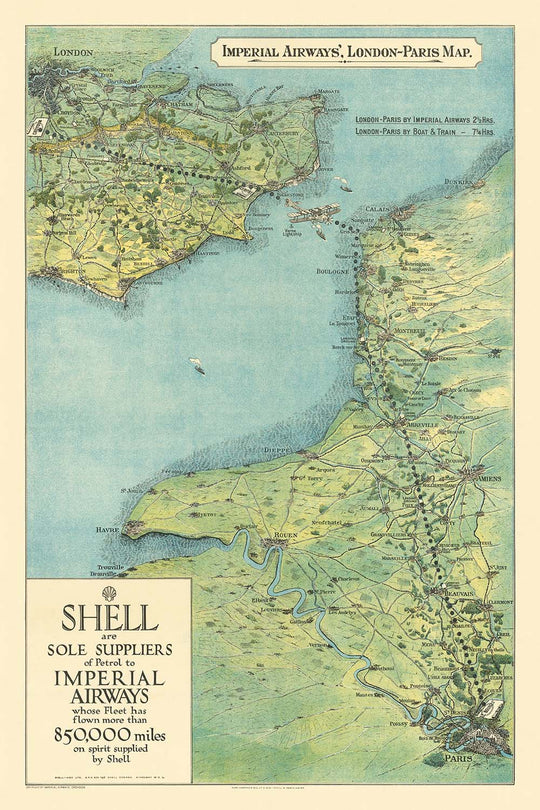
Entra nell'età dell'oro dell'aviazione con questa eccezionale mappa illustrata del 1928, commissionata da Imperial Airways in collaborazione con Shell. Questa mappa cattura la storica rotta aerea Londra-Parigi, uno dei primi e più celebri voli internazionali passeggeri al mondo. Illustrata con una vibrante prospettiva a volo d'uccello, traccia il viaggio dall'aeroporto di Croydon, appena fuori Londra, all'aeroporto di Le Bourget, a nord di Parigi, sorvolando con grazia l'iconico Canale della Manica. Le lussureggianti tonalità blu-verdi della mappa e i dettagli pastorali affascinanti evocano lo spirito di avventura e innovazione che ha definito l'epoca.
Storicamente, questa mappa segna un momento cruciale nell'evoluzione dell'aviazione commerciale. Imperial Airways, la compagnia aerea britannica pionieristica a lungo raggio, operava questa rotta in un'epoca in cui il viaggio aereo era ancora un'impresa audace. Nei suoi primi sei anni, la compagnia aerea ha subito sette incidenti importanti, sottolineando i rischi affrontati dai primi passeggeri e membri dell'equipaggio. Tuttavia, questa stessa rotta è diventata un simbolo di progresso, offrendo ai viaggiatori non solo velocità ma anche un senso di lusso moderno—ulteriormente immortalizzata come la prima rotta aerea a proiettare un film per i suoi passeggeri, il classico del 1925 "The Lost World."
L'arte della mappa è tanto informativa quanto incantevole. Le principali città e i luoghi di interesse sono accuratamente illustrati lungo il percorso, tra cui Londra, Parigi, Dover, Calais, Boulogne, Amiens e Beauvais. Il Canale della Manica è rappresentato con chiarezza, enfatizzando la sfida tecnica e navigazionale che ha posto ai primi aviatori. La prominente rappresentazione del biplano Handley Page Type W, una meraviglia del suo tempo, serve come testimonianza dell'ingegnosità e dell'ambizione che hanno spinto avanti il volo commerciale.
Oltre alla sua funzione immediata come strumento di viaggio e pezzo promozionale, questa mappa si erge come un artefatto culturale dell'Europa tra le due guerre. Riflette non solo l'ottimismo degli anni '20 ma anche lo spirito collaborativo tra giganti dell'industria come Imperial Airways e Shell. Le scelte di branding e design curate evidenziano la crescente relazione tra l'aviazione e le industrie petrolifere, entrambe essenziali per la rapida espansione della connettività globale.
Per collezionisti e appassionati di storia, questa mappa offre un legame tangibile con l'alba del moderno viaggio aereo. Invita gli spettatori a immaginare l'eccitazione e l'incertezza di quei primi voli attraverso il Canale, dove ogni viaggio era sia un atto di fede che una celebrazione del progresso umano. Come pezzo di storia cartografica, è un tributo ai visionari che hanno ristretto i continenti e avvicinato il mondo—un volo alla volta.
Luoghi su questa mappa
- Londra
- Aeroporto di Croydon
- Canale della Manica
- Parigi
- Aeroporto di Le Bourget
- Dover
- Calais
- Boulogne
- Amiens
- Beauvais
- Fiume Tamigi
- Fiume Senna
Caratteristiche e Luoghi di Interesse
- Chiara rappresentazione della rotta aerea da Londra (Aeroporto di Croydon) a Parigi (Aeroporto di Le Bourget)
- Biplano illustrato (aereo Handley Page Type W) mostrato in volo sopra il Canale della Manica
- Rappresentazione pastorale e scenica della campagna inglese e francese
- Illustrazioni stilizzate di città, paesi e luoghi di interesse lungo il percorso
- Enfasi visiva sulla facilità e il comfort dei primi viaggi aerei
- Branding di Imperial Airways e Shell chiaramente visibile
- Rappresentazione degli aeroporti di Croydon e Le Bourget, che segnano i punti di inizio e fine della rotta
Contesto storico e di design
- Nome della mappa: Mappa di Londra-Parigi delle Imperial Airways
- Data di creazione: 1928
- Editore/Cartografo: Imperial Airways, in collaborazione con Shell (Shell-Mex), promuovendo i viaggi aerei e i prodotti petroliferi
- Imperial Airways era una delle prime compagnie aeree commerciali britanniche, operante dal 1924 al 1939, nota per aver pionierato i voli commerciali a lungo raggio e l'aviazione passeggeri precoce
- La rotta Londra-Parigi era tra le prime rotte aeree commerciali per passeggeri, segnando un significativo progresso nei viaggi aerei internazionali
- Questa rotta è storicamente notevole per essere stata la prima a proiettare un film in volo, "Il Mondo Perduto" (1925)
- La mappa è pittorica e tematica, utilizzando una prospettiva a volo d'uccello con piacevoli colori pastello blu-verdi per trasmettere un senso di facilità, comfort e modernità associato ai viaggi aerei
- Nonostante la rappresentazione invitante, la prima aviazione era pericolosa: Imperial Airways ha avuto 7 incidenti che hanno causato 32 vittime nei suoi primi sei anni di operazione
- La mappa presenta in modo prominente una variante a tre motori dell'aereo Handley Page Type W, probabilmente il modello W.8f introdotto intorno al 1924
- Riflette lo spirito collaborativo tra giganti dell'industria come Imperial Airways e Shell, e la crescente relazione tra le industrie dell'aviazione e del petrolio
Si prega di controllare attentamente le immagini per assicurarsi che una specifica città o luogo sia mostrato su questa mappa. Puoi anche contattarci e chiedere di controllare la mappa per te.
Questa mappa appare fantastica in ogni dimensione, ma consiglio sempre di optare per una dimensione più grande se hai spazio. In questo modo puoi facilmente distinguere tutti i dettagli.
Questa mappa appare incredibile in dimensioni fino a 100in (250cm). Se stai cercando una mappa più grande, per favore contattaci.
Si prega di notare: le etichette su questa mappa sono difficili da leggere se ordini una mappa che è 16in (40cm) o più piccola. La mappa è comunque molto attraente, ma se desideri leggere la mappa facilmente, ti preghiamo di acquistare una dimensione più grande.
Il modello nelle immagini dell'annuncio tiene la versione della mappa 24x36in (60x90cm).
La quinta immagine dell'annuncio mostra un esempio del mio servizio di personalizzazione della mappa.
Se stai cercando qualcosa di leggermente diverso, dai un'occhiata alla mia collezione delle migliori mappe antiche per vedere se qualcosa colpisce la tua attenzione.
Per favore contattami per verificare se una certa località, punto di riferimento o caratteristica è mostrata su questa mappa.
Questo sarebbe un meraviglioso regalo per un compleanno, Natale, Festa del Papà, un addio al lavoro, un anniversario o un regalo per una nuova casa per qualcuno delle aree coperte da questa mappa.
Questa mappa è disponibile come stampa giclée su carta opaca archiviata priva di acidi, oppure puoi acquistarla incorniciata. La cornice è una semplice cornice nera che si adatta alla maggior parte degli stili. Ti preghiamo di contattarci se desideri un colore o un materiale di cornice diverso. Le mie cornici sono dotate di un acrilico di grado museale super chiaro (perspex/acrylite), che è significativamente meno riflettente del vetro, più sicuro e arriverà sempre in perfette condizioni.
This map is also available as a float framed canvas, sometimes known as a shadow gap framed canvas or canvas floater. The map is printed on artist's cotton canvas and then stretched over a handmade box frame. We then "float" the canvas inside a wooden frame, which is available in a range of colours (black, dark brown, oak, antique gold and white). This is a wonderful way to present a map without glazing in front. See some examples of float framed canvas maps and explore the differences between my different finishes.
For something truly unique, this map is also available in "Unique 3D", our trademarked process that dramatically transforms the map so that it has a wonderful sense of depth. We combine the original map with detailed topography and elevation data, so that mountains and the terrain really "pop". For more info and examples of 3D maps, check my Unique 3D page.
For most orders, delivery time is about 3 working days. Personalised and customised products take longer, as I have to do the personalisation and send it to you for approval, which usually takes 1 or 2 days.
Please note that very large framed orders usually take longer to make and deliver.
If you need your order to arrive by a certain date, please contact me before you order so that we can find the best way of making sure you get your order in time.
I print and frame maps and artwork in 23 countries around the world. This means your order will be made locally, which cuts down on delivery time and ensures that it won't be damaged during delivery. You'll never pay customs or import duty, and we'll put less CO2 into the air.
All of my maps and art prints are well packaged and sent in a rugged tube if unframed, or surrounded by foam if framed.
I try to send out all orders within 1 or 2 days of receiving your order, though some products (like face masks, mugs and tote bags) can take longer to make.
If you select Express Delivery at checkout your order we will prioritise your order and send it out by 1-day courier (Fedex, DHL, UPS, Parcelforce).
Next Day delivery is also available in some countries (US, UK, Singapore, UAE) but please try to order early in the day so that we can get it sent out on time.
My standard frame is a gallery style black ash hardwood frame. It is simple and quite modern looking. My standard frame is around 20mm (0.8in) wide.
I use super-clear acrylic (perspex/acrylite) for the frame glass. It's lighter and safer than glass - and it looks better, as the reflectivity is lower.
Six standard frame colours are available for free (black, dark brown, dark grey, oak, white and antique gold). Custom framing and mounting/matting is available if you're looking for something else.
Most maps, art and illustrations are also available as a framed canvas. We use matte (not shiny) cotton canvas, stretch it over a sustainably sourced box wood frame, and then 'float' the piece within a wood frame. The end result is quite beautiful, and there's no glazing to get in the way.
All frames are provided "ready to hang", with either a string or brackets on the back. Very large frames will have heavy duty hanging plates and/or a mounting baton. If you have any questions, please get in touch.
See some examples of my framed maps and framed canvas maps.
Alternatively, I can also supply old maps and artwork on canvas, foam board, cotton rag and other materials.
If you want to frame your map or artwork yourself, please read my size guide first.
Alcune delle mie vecchie mappe sono ora disponibili come tele incorniciate. Per favore contattami se desideri ordinare una dimensione che non è disponibile nel mio negozio.
Le vecchie mappe su tela sono un'alternativa interessante alle mappe incorniciate in modo convenzionale. A seconda del tuo gusto personale e dell'arredamento della stanza, le mappe su tela possono "risaltare" un po' di più rispetto a una mappa incorniciata.
My maps are extremely high quality reproductions of original maps.
I source original, rare maps from libraries, auction houses and private collections around the world, restore them at my London workshop, and then use specialist giclée inks and printers to create beautiful maps that look even better than the original.
My maps are printed on acid-free archival matte (not glossy) paper that feels very high quality and almost like card. In technical terms the paper weight/thickness is 10mil/200gsm. It's perfect for framing.
I print with Epson ultrachrome giclée UV fade resistant pigment inks - some of the best inks you can find.
I can also make maps on canvas, cotton rag and other exotic materials.
Learn more about The Unique Maps Co.
Map personalisation
If you're looking for the perfect anniversary or housewarming gift, I can personalise your map to make it truly unique. For example, I can add a short message, or highlight an important location, or add your family's coat of arms.
The options are almost infinite. Please see my map personalisation page for some wonderful examples of what's possible.
To order a personalised map, select "personalise your map" before adding it to your basket.
Get in touch if you're looking for more complex customisations and personalisations.
Map ageing
I have been asked hundreds of times over the years by customers if they could buy a map that looks even older.
Well, now you can, by selecting Aged before you add a map to your basket.
All the product photos you see on this page show the map in its Original form. This is what the map looks like today.
If you select Aged, I will age your map by hand, using a special and unique process developed through years of studying old maps, talking to researchers to understand the chemistry of aging paper, and of course... lots of practice!
If you're unsure, stick to the Original colour of the map. If you want something a bit darker and older looking, go for Aged.
Se non sei soddisfatto del tuo ordine per qualsiasi motivo, contattami per un rimborso senza problemi. Si prega di consultare la nostra politica di reso e rimborso per ulteriori informazioni.
Sono molto sicuro che ti piacerà la tua mappa restaurata o la stampa d'arte. Lo faccio dal 1984. Sono un venditore Etsy a 5 stelle. Ho venduto decine di migliaia di mappe e stampe d'arte e ho oltre 5.000 recensioni reali a 5 stelle.
Utilizzo un processo unico per restaurare mappe e opere d'arte che richiede molto tempo e lavoro. Trovare le mappe e le illustrazioni originali può richiedere mesi. Utilizzo tecnologia all'avanguardia e incredibilmente costosa per scannerizzare e restaurarle. Di conseguenza, garantisco che le mie mappe e stampe d'arte siano superiori alle altre - ecco perché posso offrire un rimborso senza problemi.
Quasi tutte le mie mappe e stampe d'arte sembrano fantastiche a grandi dimensioni (200 cm, 6,5 piedi+) e posso anche incorniciarle e consegnarle a te, tramite un corriere speciale per oggetti di grandi dimensioni. Contattami per discutere delle tue esigenze specifiche.
Or try searching for something!


