

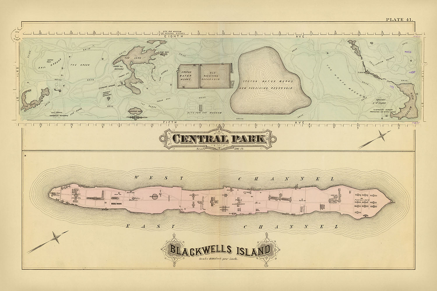

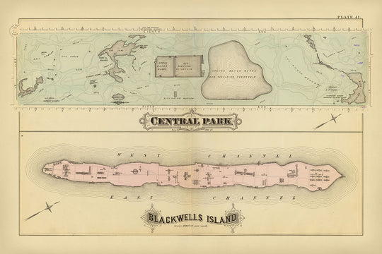


Mappa antica di Central Park e dell'Isola di Blackwell, NYC di Bromley, 1879: Il Lago, Lo Stagno, Harlem Meer

- All taxes and duties included
- Handmade & dispatched in 1-2 days
-
90 day money back guarantee
ⓘ
90 giorni per restituire e ottenere un rimborso
I prodotti possono essere restituiti entro 90 giorni per un rimborso completo, o scambio con un altro prodotto.
Per articoli personalizzati o su misura, potremmo offrirti un credito in negozio o una carta regalo non scadente, poiché non possiamo rivendere ordini personalizzati.
Se hai domande, contattaci. Per ulteriori informazioni, consulta la nostra politica di restituzione e scambio.

My maps are rare, museum-grade, restored old maps sourced from libraries, auction houses and private collections across the globe.
Framing & free personalisation available
1. Select your size
2. Frame & personalise your map
Make your map unique with framing, hand-drawn customisation, vintage ageing, pop art text, unique 3D styling and moreGift message & custom finish

If you want to add a gift message, or a finish (jigsaw, aluminium board, etc.) that is not available here, please request it in the "order note" when you check out.
Every order is custom made, so if you need the size adjusted slightly, or printed on an unusual material, just let us know. We've done thousands of custom orders over the years, so there's (almost) nothing we can't manage.
You can also contact us before you order, if you prefer!

- Handmade locally. No import duty or tax
- FREE Delivery. Arrives in 2-3 days
- Love it or your money back
- Questions? WhatsApp me any time
Own a piece of history
5,000+ 5 star reviews


La mappa intitolata "Central Park e Blackwells Island, New York City," realizzata dal rinomato G.W. Bromley nel 1879, offre uno sguardo affascinante sul paesaggio urbano di New York City alla fine del XIX secolo. Questa litografia a mano colorata fornisce un ritratto intricato di due aree significative: l'iconico Central Park e il storicamente ricco Blackwells Island, ora conosciuto come Roosevelt Island. La rappresentazione dettagliata della mappa di edifici, strade, sentieri, serbatoi e laghi la rende un pezzo inestimabile sia per storici che per appassionati di sviluppo urbano.
Central Park, il cuore verde di Manhattan, è presentato in dettagli squisiti. Progettato da Frederick Law Olmsted e Calvert Vaux, la rete intricata di sentieri del parco, laghi sereni e punti di riferimento notevoli come The Pond, The Lake e i vecchi e nuovi serbatoi di ricezione sono meticolosamente illustrati. La mappa evidenzia il ruolo del parco come un'oasi urbana pionieristica, offrendo un rifugio dalla vita frenetica della città. L'inclusione del Metropolitan Museum e dei Croton Water Works sottolinea ulteriormente il significato culturale e infrastrutturale del parco.
Blackwells Island, rappresentato con una scala di 1:4.800, offre un contesto storico affascinante. Conosciuta per le sue istituzioni, tra cui ospedali e manicomi, il layout dettagliato di edifici e strutture dell'isola fornisce una finestra sul suo passato. La mappa cattura la posizione unica dell'isola nel fiume Est, affiancata dai canali Ovest e Est, e il suo ruolo nello sviluppo della città. La trasformazione dell'isola nel corso degli anni, da luogo di confinamento a area residenziale e ricreativa, aggiunge un ulteriore strato di intrigo storico.
Il design e lo stile della mappa, caratterizzati da litografia a mano colorata, riflettono la bravura artistica e tecnica della fine del XIX secolo. L'esperienza di G.W. Bromley nella cartografia urbana è evidente nella precisione e nell'appeal estetico della mappa. Le mappe di Bromley non erano solo strumenti di navigazione, ma anche opere d'arte che catturavano l'essenza del paesaggio in evoluzione della città. Questa mappa, in particolare, si distingue per la sua rappresentazione dettagliata di due parti contrastanti ma integrali di New York City.
Il significato storico di questa mappa va oltre il suo fascino visivo. Essa serve come testimonianza degli sforzi di pianificazione e sviluppo urbano dell'epoca, evidenziando la crescita e la trasformazione della città. Il design di Central Park come spazio pubblico e la storia istituzionale di Blackwells Island sono entrambi capitoli cruciali nella storia di New York City. Questa mappa non è solo una rappresentazione della geografia, ma una narrazione del passato della città, rendendola un possesso prezioso per collezionisti e appassionati di storia.
Caratteristiche e punti di riferimento notevoli
- The Pond
- The Lake
- Conservatory Water
- Old Receiving Reservoir
- New Receiving Reservoir
- Metropolitan Museum
- Ball Grounds
- The Green
- The Ramble
- Croton Water Works
- Harlem Meer
- The North Meadow
Contesto storico e di design
- Nome della mappa: Central Park e Blackwells Island, New York City
- Quando è stata realizzata la mappa: 1879
- Cartografo o editore: G.W. Bromley
- Contesto interessante sul cartografo: G.W. Bromley era noto per la creazione di mappe dettagliate delle città alla fine del XIX secolo, spesso utilizzate per la pianificazione e lo sviluppo urbano.
- Argomenti e temi mostrati sulla mappa:
- Central Park: Layout dettagliato dei sentieri, laghi e aree notevoli all'interno di Central Park.
- Isola di Blackwell: Layout dettagliato degli edifici e delle strutture sull'isola.
- Paesi e regioni mostrati sulla mappa: New York City, Stati Uniti
- Design o stile della mappa: Litografia a mano colorata, che era una tecnica comune nel XIX secolo per produrre mappe dettagliate e colorate.
- Significato storico o contesto della mappa:
- Central Park, progettato da Frederick Law Olmsted e Calvert Vaux, è stato un parco urbano pionieristico negli Stati Uniti.
- Isola di Blackwell (ora conosciuta come Isola di Roosevelt) era storicamente significativa per le sue istituzioni, comprese ospedali e manicomi.
Si prega di controllare attentamente le immagini per assicurarsi che una specifica città o luogo sia mostrato su questa mappa. Puoi anche contattarci e chiedere di controllare la mappa per te.
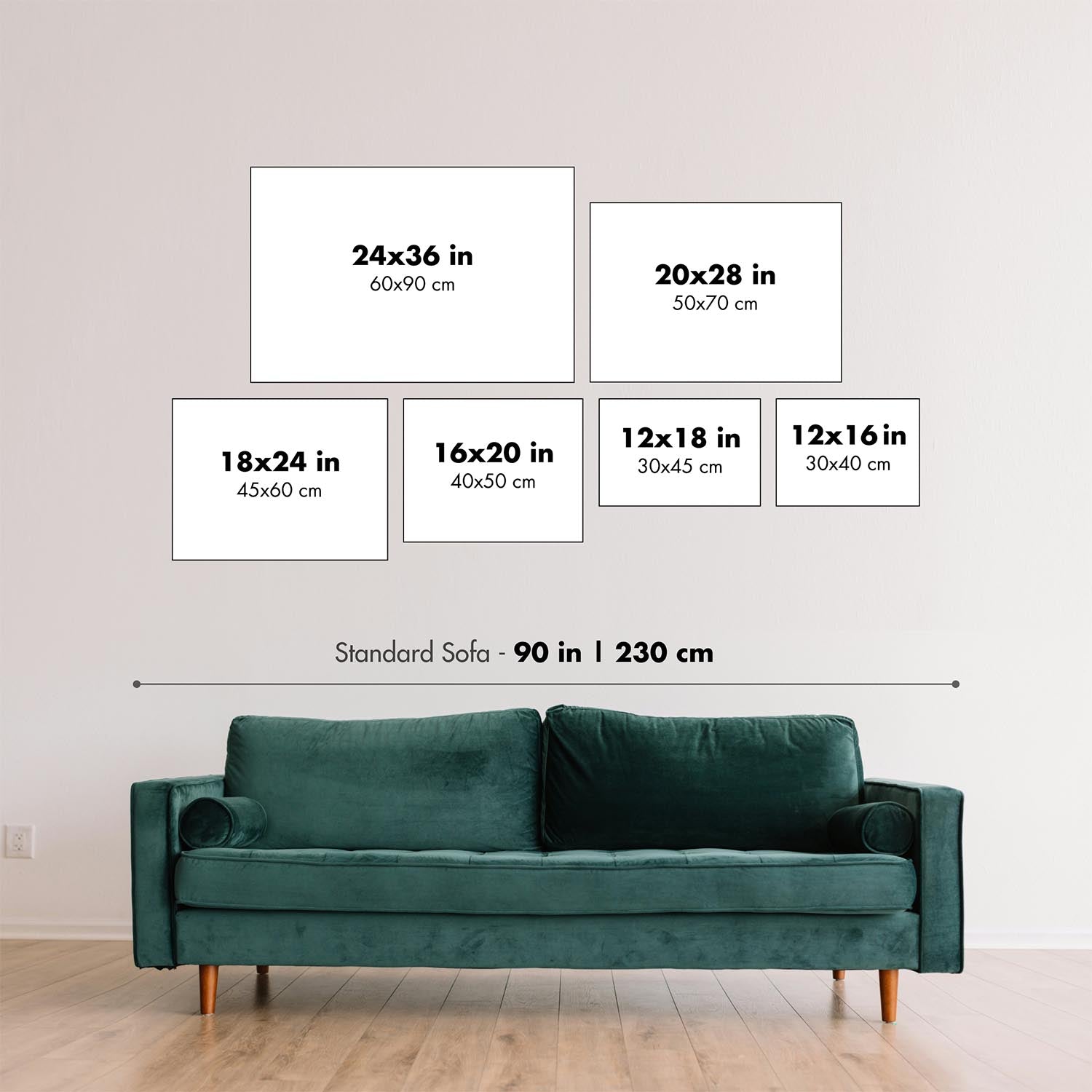
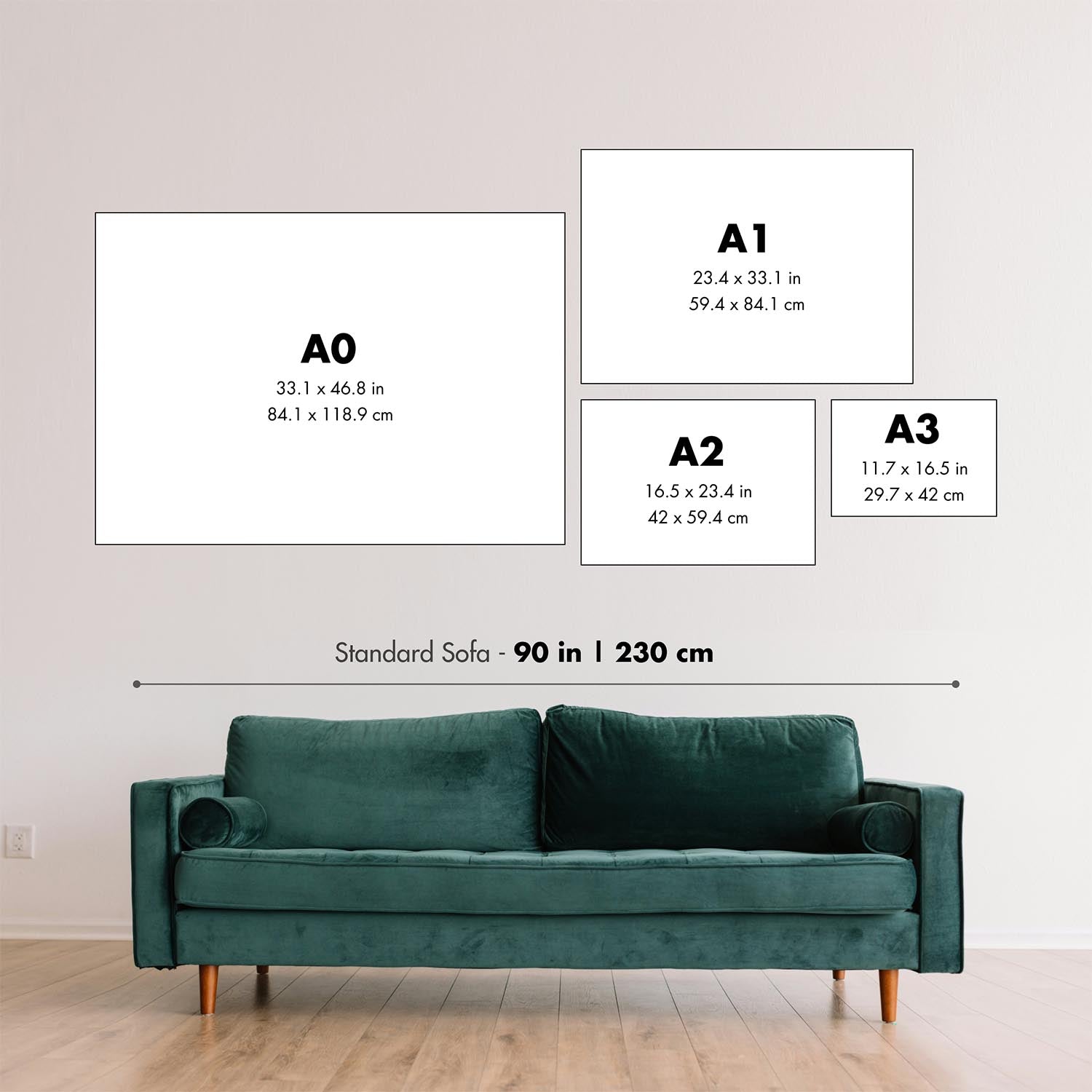
Questa mappa sembra fantastica in ogni dimensione, ma consiglio sempre di optare per una dimensione più grande se hai spazio. In questo modo puoi facilmente distinguere tutti i dettagli.
Questa mappa appare incredibile in dimensioni fino a 70in (180cm). Se stai cercando una mappa più grande, per favore contattaci.
Il modello nelle immagini dell'elenco tiene in mano la versione 24x36in (60x90cm) di questa mappa.
La quinta immagine dell'elenco mostra un esempio del mio servizio di personalizzazione della mappa.
Se stai cercando qualcosa di leggermente diverso, dai un'occhiata alla mia collezione delle migliori vecchie mappe per vedere se qualcosa attira la tua attenzione.
Per favore contattami per controllare se una certa posizione, punto di riferimento o caratteristica è mostrata su questa mappa.
Questo sarebbe un meraviglioso regalo di compleanno, Natale, Festa del Papà, addio al lavoro, anniversario o regalo per una nuova casa per qualcuno delle aree coperte da questa mappa.
Questa mappa è disponibile come stampa giclée su carta opaca archiviata priva di acidi, oppure puoi acquistarla incorniciata. La cornice è una bella e semplice cornice nera che si adatta alla maggior parte degli stili. Ti prego di contattarmi se desideri un colore o un materiale di cornice diverso. Le mie cornici sono rivestite con acrilico super chiaro di grado museale (perspex/acrylite), che è significativamente meno riflettente del vetro, più sicuro e arriverà sempre in perfette condizioni.
This map is also available as a float framed canvas, sometimes known as a shadow gap framed canvas or canvas floater. The map is printed on artist's cotton canvas and then stretched over a handmade box frame. We then "float" the canvas inside a wooden frame, which is available in a range of colours (black, dark brown, oak, antique gold and white). This is a wonderful way to present a map without glazing in front. See some examples of float framed canvas maps and explore the differences between my different finishes.
For something truly unique, this map is also available in "Unique 3D", our trademarked process that dramatically transforms the map so that it has a wonderful sense of depth. We combine the original map with detailed topography and elevation data, so that mountains and the terrain really "pop". For more info and examples of 3D maps, check my Unique 3D page.
For most orders, delivery time is about 3 working days. Personalised and customised products take longer, as I have to do the personalisation and send it to you for approval, which usually takes 1 or 2 days.
Please note that very large framed orders usually take longer to make and deliver.
If you need your order to arrive by a certain date, please contact me before you order so that we can find the best way of making sure you get your order in time.
I print and frame maps and artwork in 23 countries around the world. This means your order will be made locally, which cuts down on delivery time and ensures that it won't be damaged during delivery. You'll never pay customs or import duty, and we'll put less CO2 into the air.
All of my maps and art prints are well packaged and sent in a rugged tube if unframed, or surrounded by foam if framed.
I try to send out all orders within 1 or 2 days of receiving your order, though some products (like face masks, mugs and tote bags) can take longer to make.
If you select Express Delivery at checkout your order we will prioritise your order and send it out by 1-day courier (Fedex, DHL, UPS, Parcelforce).
Next Day delivery is also available in some countries (US, UK, Singapore, UAE) but please try to order early in the day so that we can get it sent out on time.
My standard frame is a gallery style black ash hardwood frame. It is simple and quite modern looking. My standard frame is around 20mm (0.8in) wide.
I use super-clear acrylic (perspex/acrylite) for the frame glass. It's lighter and safer than glass - and it looks better, as the reflectivity is lower.
Six standard frame colours are available for free (black, dark brown, dark grey, oak, white and antique gold). Custom framing and mounting/matting is available if you're looking for something else.
Most maps, art and illustrations are also available as a framed canvas. We use matte (not shiny) cotton canvas, stretch it over a sustainably sourced box wood frame, and then 'float' the piece within a wood frame. The end result is quite beautiful, and there's no glazing to get in the way.
All frames are provided "ready to hang", with either a string or brackets on the back. Very large frames will have heavy duty hanging plates and/or a mounting baton. If you have any questions, please get in touch.
See some examples of my framed maps and framed canvas maps.
Alternatively, I can also supply old maps and artwork on canvas, foam board, cotton rag and other materials.
If you want to frame your map or artwork yourself, please read my size guide first.
Alcune delle mie vecchie mappe sono ora disponibili come tele incorniciate. Per favore contattami se desideri ordinare una dimensione che non è disponibile nel mio negozio.
Le vecchie mappe su tela sono un'alternativa interessante alle mappe incorniciate in modo convenzionale. A seconda del tuo gusto personale e dell'arredamento della stanza, le mappe su tela possono "risaltare" un po' di più rispetto a una mappa incorniciata.
My maps are extremely high quality reproductions of original maps.
I source original, rare maps from libraries, auction houses and private collections around the world, restore them at my London workshop, and then use specialist giclée inks and printers to create beautiful maps that look even better than the original.
My maps are printed on acid-free archival matte (not glossy) paper that feels very high quality and almost like card. In technical terms the paper weight/thickness is 10mil/200gsm. It's perfect for framing.
I print with Epson ultrachrome giclée UV fade resistant pigment inks - some of the best inks you can find.
I can also make maps on canvas, cotton rag and other exotic materials.
Learn more about The Unique Maps Co.
Map personalisation
If you're looking for the perfect anniversary or housewarming gift, I can personalise your map to make it truly unique. For example, I can add a short message, or highlight an important location, or add your family's coat of arms.
The options are almost infinite. Please see my map personalisation page for some wonderful examples of what's possible.
To order a personalised map, select "personalise your map" before adding it to your basket.
Get in touch if you're looking for more complex customisations and personalisations.
Map ageing
I have been asked hundreds of times over the years by customers if they could buy a map that looks even older.
Well, now you can, by selecting Aged before you add a map to your basket.
All the product photos you see on this page show the map in its Original form. This is what the map looks like today.
If you select Aged, I will age your map by hand, using a special and unique process developed through years of studying old maps, talking to researchers to understand the chemistry of aging paper, and of course... lots of practice!
If you're unsure, stick to the Original colour of the map. If you want something a bit darker and older looking, go for Aged.
Se non sei soddisfatto del tuo ordine per qualsiasi motivo, contattami per un rimborso senza problemi. Si prega di consultare la nostra politica di reso e rimborso per ulteriori informazioni.
Sono molto sicuro che ti piacerà la tua mappa restaurata o la stampa d'arte. Lo faccio dal 1984. Sono un venditore Etsy a 5 stelle. Ho venduto decine di migliaia di mappe e stampe d'arte e ho oltre 5.000 recensioni reali a 5 stelle.
Utilizzo un processo unico per restaurare mappe e opere d'arte che richiede molto tempo e lavoro. Trovare le mappe e le illustrazioni originali può richiedere mesi. Utilizzo tecnologia all'avanguardia e incredibilmente costosa per scannerizzare e restaurarle. Di conseguenza, garantisco che le mie mappe e stampe d'arte siano superiori alle altre - ecco perché posso offrire un rimborso senza problemi.
Quasi tutte le mie mappe e stampe d'arte sembrano fantastiche a grandi dimensioni (200 cm, 6,5 piedi+) e posso anche incorniciarle e consegnarle a te, tramite un corriere speciale per oggetti di grandi dimensioni. Contattami per discutere delle tue esigenze specifiche.
Or try searching for something!


