


Mappa antica dell'Impero Ottomano di Visscher, 1690: Medio Oriente, Europa meridionale, Africa nordorientale, Mare Mediterraneo, Mar Rosso
- All taxes and duties included
- Handmade & dispatched in 1-2 days
-
90 day money back guarantee
ⓘ
90 giorni per restituire e ricevere un rimborso
I prodotti possono essere restituiti entro 90 giorni per un rimborso completo, o cambio con un altro prodotto.
Per articoli personalizzati e su misura, potremmo offrirti un credito in negozio o una carta regalo non scadente, poiché non possiamo rivendere ordini personalizzati.
Se hai domande, contattaci. Per ulteriori informazioni, consulta la nostra politica di restituzione e cambio.

My maps are rare, museum-grade, restored old maps sourced from libraries, auction houses and private collections across the globe.
Framing & free personalisation available
1. Select your size
2. Frame & personalise your map
There is limited framing & personalisation capacity available. Order by 10am tomorrow for Christmas delivery.


Gift message & custom finish

If you want to add a gift message, or a finish (jigsaw, aluminium board, etc.) that is not available here, please request it in the "order note" when you check out.
Every order is custom made, so if you need the size adjusted slightly, or printed on an unusual material, just let us know. We've done thousands of custom orders over the years, so there's (almost) nothing we can't manage.
You can also contact us before you order, if you prefer!

- Handmade locally. No import duty or tax
- FREE Delivery by Christmas
- Love it or your money back (90 days)
- Questions? WhatsApp me any time
Own a piece of history
5,000+ 5 star reviews


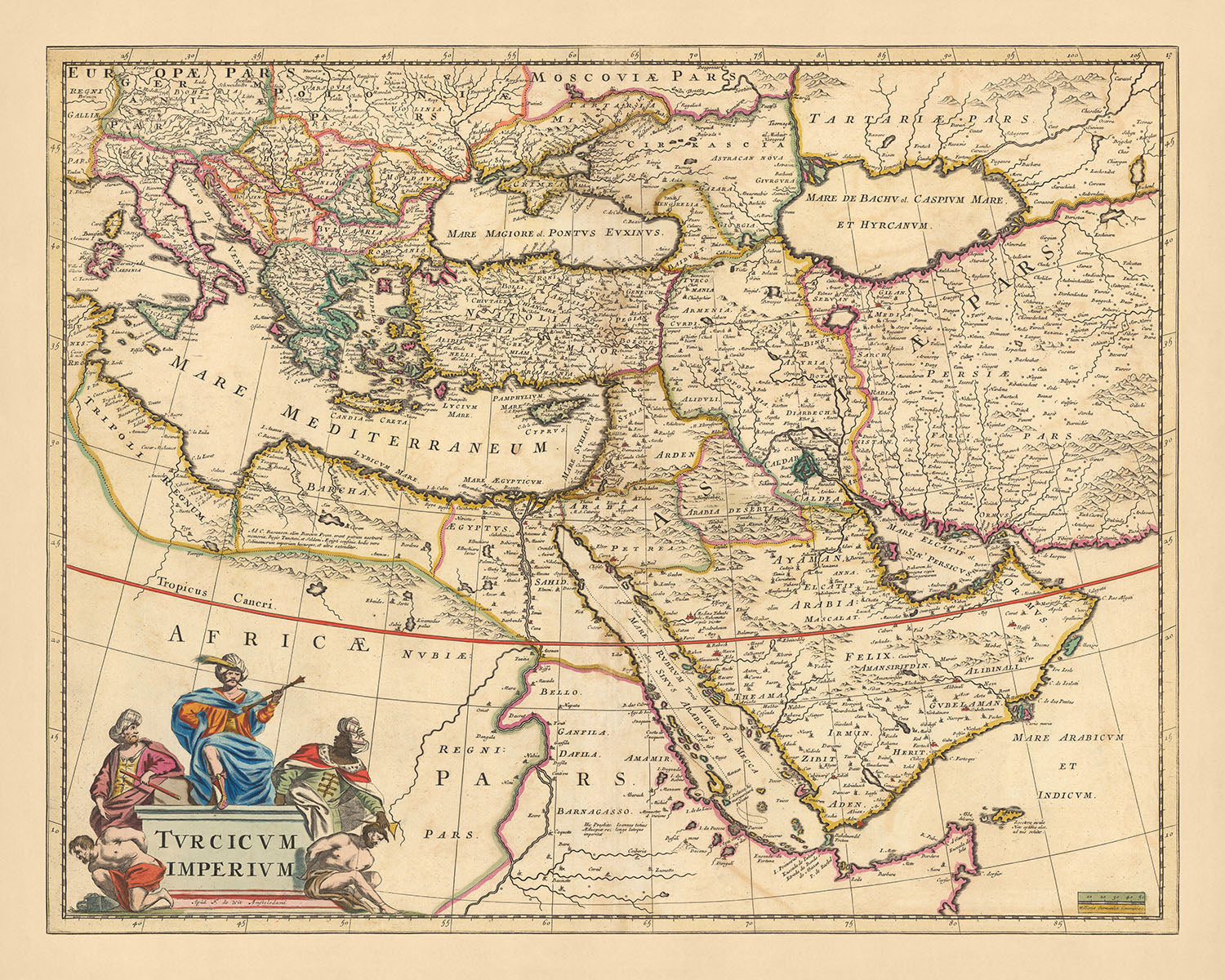
Ecco la maestà del 'Turcicum imperium', una mappa storica affascinante che ti riporta all'espansione dell'Impero Ottomano alla fine del XVII secolo. Realizzata dal rinomato Nicolaes Visscher II, questa mappa è una testimonianza delle eccezionali abilità cartografiche dell'età d'oro olandese. Il nipote di Claes Janszoon Visscher, uno dei migliori cartografi del suo tempo, Nicolaes Visscher II, ha infuso in questa mappa un'attenzione ai dettagli e un'accuratezza che erano caratteristiche della sua discendenza. Tradotta in 'L'Impero Turco', questa mappa racchiude i vasti territori dell'Impero Ottomano, che si estendono dal Medio Oriente all'Europa meridionale e all'Africa nord-orientale.
Il 'Turcicum imperium' non è solo una mappa, ma una tela vivace che dipinge un quadro vivido del mondo così com'era conosciuto nel 1690. Mostra città significative, regioni e punti di riferimento dell'epoca, dal vivace Mar Mediterraneo al tranquillo Mar Rosso. L'intricata mappa si estende alla rappresentazione dei confini politici e amministrativi, delle vie d'acqua, dei canali e persino dei punti di riferimento. Porta in vita la grandezza dell'Impero Ottomano, estendendosi a nord fino all'Ungheria e alla Circassia, a est fino alla Persia e comprendendo l'intera penisola arabica.
Questa mappa è un piacere visivo, adornata con un cartiglio decorativo che aggiunge al suo fascino estetico. Il rilievo mostrato in modo pittorico aggiunge un tocco di realismo, rendendo la mappa più di una semplice rappresentazione di luoghi geografici. È un documento storico che offre uno sguardo nel passato, con ogni contorno colorato a mano che racconta una storia a sé. Dalle maestose montagne ai laghi sereni, il 'Turcicum imperium' è una testimonianza dell'immensità e della diversità dell'Impero Ottomano.
Il 'Turcicum imperium' è più di un'opera d'arte; è un artefatto storico che ti riporta indietro nel tempo. È una testimonianza della grandezza dell'Impero Ottomano, una capsula temporale che racchiude il panorama geopolitico del XVII secolo. Con i suoi dettagli intricati e le sue immagini mozzafiato, questa mappa è un tesoro per gli appassionati di storia, gli amanti delle mappe e chiunque abbia un apprezzamento per il passato. Che tu sia un collezionista o semplicemente qualcuno che apprezza la bellezza delle mappe storiche, il 'Turcicum imperium' è un pezzo che promette di essere un argomento di conversazione.
Alcuni dei luoghi significativi mostrati su questa mappa:
Medio Oriente 1. Costantinopoli (Istanbul) - Conosciuta come la capitale dell'Impero Ottomano, era un importante centro di commercio e cultura. 2. Baghdad - Un importante centro dell'età d'oro islamica durante il Califfato Abbaside. 3. Damasco - Conosciuta come la capitale del Califfato Omayyade e una delle città continuamente abitate più antiche del mondo. 4. Gerusalemme - Una città di immensa importanza religiosa per l'ebraismo, il cristianesimo e l'islam. 5. Mecca - Il luogo di nascita di Maometto e il sito della Kaaba, il santuario più sacro dell'islam. 6. Medina - Il luogo di sepoltura di Maometto e la seconda città più sacra dell'islam. 7. Il Cairo - La capitale dell'Egitto e una delle città più grandi dell'Africa. 8. Aleppo - Una delle città continuamente abitate più antiche del mondo. 9. Basra - Una grande città portuale nel sud dell'Iraq. 10. Tabriz - La capitale della provincia dell'Azerbaigian orientale, nel nord-ovest dell'Iran.
Europa meridionale 1. Atene - La capitale della Grecia e una delle città più antiche del mondo. 2. Salonicco - La seconda città più grande della Grecia e un importante centro economico, industriale, commerciale e politico. 3. Sofia - La capitale e la città più grande della Bulgaria. 4. Belgrado - La capitale della Serbia, è abitata sin dall'età paleolitica. 5. Bucarest - La capitale e la città più grande della Romania. 6. Budapest - La capitale e la città più popolosa dell'Ungheria. 7. Vienna - La capitale dell'Austria, nota per i suoi eventi culturali, i luoghi imperiali, le caffetterie, le accoglienti osterie e il molto speciale fascino viennese. 8. Praga - La capitale della Repubblica Ceca e una delle città più grandi dell'Unione Europea. 9. Venezia - Conosciuta per la sua bellezza, architettura e opere d'arte, ha avuto un ruolo essenziale nel Rinascimento. 10. Napoli - La terza città più grande d'Italia e la città più grande del sud Italia.
Africa del Nordest 1. Alessandria - Fondata da Alessandro Magno, è stata la capitale dell'Egitto greco-romano. 2. Il Cairo - La capitale dell'Egitto e una delle città più grandi dell'Africa. 3. Luxor - Conosciuta come Tebe nell'antichità, è stata la capitale dell'Egitto durante parti del periodo faraonico. 4. Aswan - Una posizione strategica che ospitava le cave di pietra utilizzate per costruire le Piramidi. 5. Khartoum - La capitale del Sudan, dove i fiumi Nilo Blu e Nilo Bianco si incontrano. 6. Mogadiscio - La capitale e la città più popolosa della Somalia. 7. Massawa - Una città portuale sul Mar Rosso, è stata la capitale della colonia italiana dell'Eritrea. 8. Gondar - Un tempo capitale dell'Impero etiope. 9. Axum - Un'antica città che era un tempo il centro dell'Impero aksumita. 10. Harar - Considerata la quarta città più sacra dell'Islam.
Fenomeni Naturali Notabili 1. Fiume Nilo - Il fiume più lungo del mondo, è stato vitale per la civiltà dell'Antico Egitto. 2. Fiume Danubio - Il secondo fiume più lungo d'Europa, scorre attraverso dieci paesi. 3. Mar Rosso - Un'insenatura d'acqua di mare dell'Oceano Indiano, situata tra Africa e Asia. 4. Mar Mediterraneo - Collegato all'Oceano Atlantico, è quasi completamente racchiuso dalla terra. 5. Monte Ararat - La vetta più alta della Turchia, è tradizionalmente associata alla montagna dove l'Arca di Noè si fermò.
Eventi Storici Notabili (1600-1690) 1. La Battaglia di Vienna (1683) - L'Impero Ottomano è stato sconfitto dall'Impero Romano Sacro, segnando l'inizio della fine dell'espansione ottomana in Europa. 2. La Guerra Cretese (1645-1669) - Un conflitto tra l'Impero Ottomano e la Repubblica Veneziana per il controllo di Creta. 3. Il Trattato di Karlowitz (1699) - Ha posto fine alle ostilità tra l'Impero Ottomano e la Santa Lega, una coalizione di varie potenze europee. Il trattato ha ridotto significativamente il territorio dell'Impero Ottomano in Europa.
Si prega di controllare attentamente le immagini per assicurarsi che una specifica città o luogo sia mostrato su questa mappa. Puoi anche contattarci e chiederci di controllare la mappa per te.
Questa mappa sembra fantastica in tutte le dimensioni: 12x16in (30.5x41cm), 16x20in (40.5x51cm), 18x24in (45.5x61cm), 24x30in (61x76cm), 32x40in (81.5x102cm), 40x50in (102x127cm), 48x60in (122x153cm) e 56x70in (142x178cm), ma sembra ancora meglio quando stampata in grande.
Posso creare bellissime stampe grandi di questa mappa fino a 90in (229cm). Ti prego di contattarmi se stai cercando opzioni di incorniciatura più grandi, personalizzate o diverse.
Il modello nelle immagini dell'annuncio tiene la versione 16x20in (40.5x51cm) di questa mappa.
La quinta immagine dell'annuncio mostra un esempio del mio servizio di personalizzazione della mappa.
Se stai cercando qualcosa di leggermente diverso, dai un'occhiata alla mia collezione delle migliori vecchie mappe d'Europa e delle città europee per vedere se qualcosa attira la tua attenzione.
Per favore, contattami per verificare se una certa posizione, punto di riferimento o caratteristica è mostrata su questa mappa.
Questo sarebbe un meraviglioso regalo di compleanno, Natale, Festa del Papà, partenza dal lavoro, anniversario o inaugurazione della casa per qualcuno delle aree coperte da questa mappa.
Questa mappa è disponibile come stampa giclée su carta opaca archiviata senza acidi, oppure puoi acquistarla incorniciata. La cornice è una bella e semplice cornice nera che si adatta alla maggior parte degli stili. Ti prego di contattarmi se desideri un colore o un materiale di cornice diverso. Le mie cornici sono rivestite con acrilico di grado museo super chiaro (perspex/acrylite), che è significativamente meno riflettente del vetro, più sicuro e arriverà sempre in perfette condizioni.
This map is also available as a float framed canvas, sometimes known as a shadow gap framed canvas or canvas floater. The map is printed on artist's cotton canvas and then stretched over a handmade box frame. We then "float" the canvas inside a wooden frame, which is available in a range of colours (black, dark brown, oak, antique gold and white). This is a wonderful way to present a map without glazing in front. See some examples of float framed canvas maps and explore the differences between my different finishes.
For something truly unique, this map is also available in "Unique 3D", our trademarked process that dramatically transforms the map so that it has a wonderful sense of depth. We combine the original map with detailed topography and elevation data, so that mountains and the terrain really "pop". For more info and examples of 3D maps, check my Unique 3D page.
For most orders, delivery time is about 3 working days. Personalised and customised products take longer, as I have to do the personalisation and send it to you for approval, which usually takes 1 or 2 days.
Please note that very large framed orders usually take longer to make and deliver.
If you need your order to arrive by a certain date, please contact me before you order so that we can find the best way of making sure you get your order in time.
I print and frame maps and artwork in 23 countries around the world. This means your order will be made locally, which cuts down on delivery time and ensures that it won't be damaged during delivery. You'll never pay customs or import duty, and we'll put less CO2 into the air.
All of my maps and art prints are well packaged and sent in a rugged tube if unframed, or surrounded by foam if framed.
I try to send out all orders within 1 or 2 days of receiving your order, though some products (like face masks, mugs and tote bags) can take longer to make.
If you select Express Delivery at checkout your order we will prioritise your order and send it out by 1-day courier (Fedex, DHL, UPS, Parcelforce).
Next Day delivery is also available in some countries (US, UK, Singapore, UAE) but please try to order early in the day so that we can get it sent out on time.
My standard frame is a gallery style black ash hardwood frame. It is simple and quite modern looking. My standard frame is around 20mm (0.8in) wide.
I use super-clear acrylic (perspex/acrylite) for the frame glass. It's lighter and safer than glass - and it looks better, as the reflectivity is lower.
Six standard frame colours are available for free (black, dark brown, dark grey, oak, white and antique gold). Custom framing and mounting/matting is available if you're looking for something else.
Most maps, art and illustrations are also available as a framed canvas. We use matte (not shiny) cotton canvas, stretch it over a sustainably sourced box wood frame, and then 'float' the piece within a wood frame. The end result is quite beautiful, and there's no glazing to get in the way.
All frames are provided "ready to hang", with either a string or brackets on the back. Very large frames will have heavy duty hanging plates and/or a mounting baton. If you have any questions, please get in touch.
See some examples of my framed maps and framed canvas maps.
Alternatively, I can also supply old maps and artwork on canvas, foam board, cotton rag and other materials.
If you want to frame your map or artwork yourself, please read my size guide first.
Alcune delle mie vecchie mappe sono ora disponibili come tele incorniciate. Per favore contattami se desideri ordinare una dimensione che non è disponibile nel mio negozio.
Le vecchie mappe su tela sono un'alternativa interessante alle mappe incorniciate in modo convenzionale. A seconda del tuo gusto personale e dell'arredamento della stanza, le mappe su tela possono "risaltare" un po' di più rispetto a una mappa incorniciata.
My maps are extremely high quality reproductions of original maps.
I source original, rare maps from libraries, auction houses and private collections around the world, restore them at my London workshop, and then use specialist giclée inks and printers to create beautiful maps that look even better than the original.
My maps are printed on acid-free archival matte (not glossy) paper that feels very high quality and almost like card. In technical terms the paper weight/thickness is 10mil/200gsm. It's perfect for framing.
I print with Epson ultrachrome giclée UV fade resistant pigment inks - some of the best inks you can find.
I can also make maps on canvas, cotton rag and other exotic materials.
Learn more about The Unique Maps Co.
Map personalisation
If you're looking for the perfect anniversary or housewarming gift, I can personalise your map to make it truly unique. For example, I can add a short message, or highlight an important location, or add your family's coat of arms.
The options are almost infinite. Please see my map personalisation page for some wonderful examples of what's possible.
To order a personalised map, select "personalise your map" before adding it to your basket.
Get in touch if you're looking for more complex customisations and personalisations.
Map ageing
I have been asked hundreds of times over the years by customers if they could buy a map that looks even older.
Well, now you can, by selecting Aged before you add a map to your basket.
All the product photos you see on this page show the map in its Original form. This is what the map looks like today.
If you select Aged, I will age your map by hand, using a special and unique process developed through years of studying old maps, talking to researchers to understand the chemistry of aging paper, and of course... lots of practice!
If you're unsure, stick to the Original colour of the map. If you want something a bit darker and older looking, go for Aged.
Se non sei soddisfatto del tuo ordine per qualsiasi motivo, contattami per un rimborso senza problemi. Si prega di consultare la nostra politica di reso e rimborso per ulteriori informazioni.
Sono molto sicuro che ti piacerà la tua mappa restaurata o la stampa d'arte. Lo faccio dal 1984. Sono un venditore Etsy a 5 stelle. Ho venduto decine di migliaia di mappe e stampe d'arte e ho oltre 5.000 recensioni reali a 5 stelle.
Utilizzo un processo unico per restaurare mappe e opere d'arte che richiede molto tempo e lavoro. Trovare le mappe e le illustrazioni originali può richiedere mesi. Utilizzo tecnologia all'avanguardia e incredibilmente costosa per scannerizzare e restaurarle. Di conseguenza, garantisco che le mie mappe e stampe d'arte siano superiori alle altre - ecco perché posso offrire un rimborso senza problemi.
Quasi tutte le mie mappe e stampe d'arte sembrano fantastiche a grandi dimensioni (200 cm, 6,5 piedi+) e posso anche incorniciarle e consegnarle a te, tramite un corriere speciale per oggetti di grandi dimensioni. Contattami per discutere delle tue esigenze specifiche.
Or try searching for something!


