

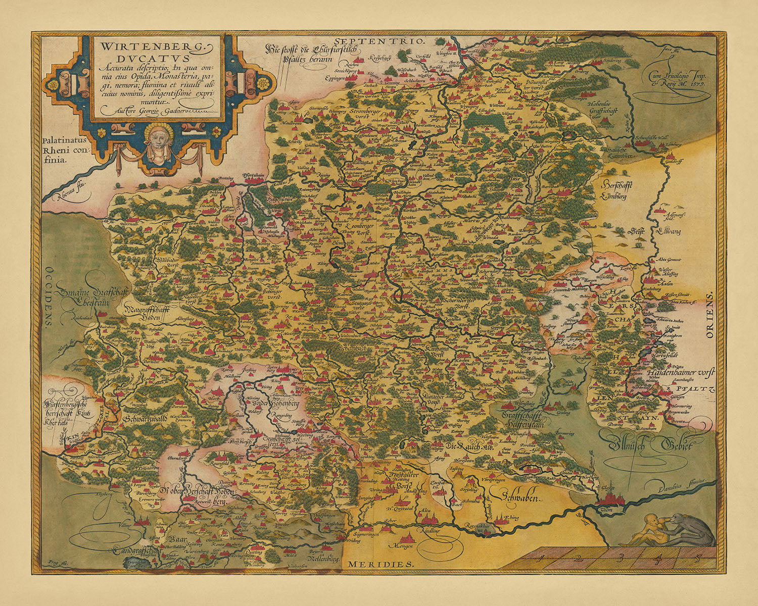

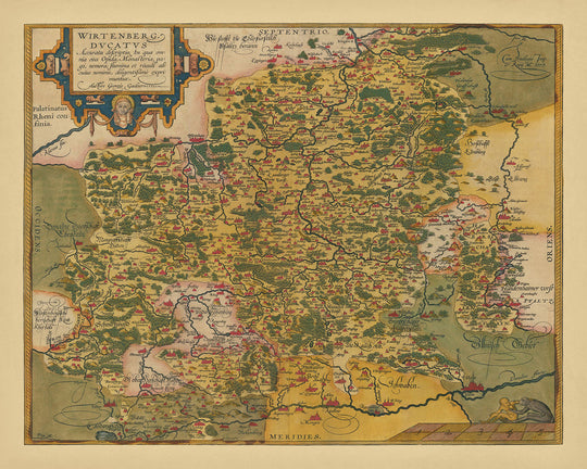


Antica mappa del Württemberg di Ortelius, 1587: Stoccarda, Ulm, Germania, fiume Neckar, foreste
Compra 2, Ricevi 1 Gratuito
Se aggiungi 2 articoli al tuo carrello, puoi aggiungere un terzo prodotto gratuitamente.
Questo vale per tutte le mappe e opere d'arte, comprese le opere personalizzate e su misura. Puoi ordinare 3 dello stesso articolo, o 3 articoli diversi.
Questo equivale a uno sconto del 33%, che sarà il maggiore sconto disponibile nel mio negozio quest'anno.
Ti prego di approfittare dell'offerta e di coprire le tue pareti con bellissime mappe e opere d'arte!
Contattami se hai domande.
- All taxes and duties included
- Handmade & dispatched in 1-2 days
-
FREE gift preview
ⓘ
Digital gift preview
After you complete your order, you can send a beautiful digital preview to the gift recipient. Just provide their email address and we'll do the rest. (Their email address will not be stored or used for any other purpose.)
This is perfect if you're concerned that your order might not arrive in time.
You can also buy a real non-expiring gift card, and email it directly to the recipient, so they can buy their own map or artwork.
-
90 day money back guarantee
ⓘ
90 giorni per restituire e ricevere un rimborso
I prodotti possono essere restituiti entro 90 giorni per un rimborso completo, o cambio con un altro prodotto.
Per articoli personalizzati e su misura, potremmo offrirti un credito in negozio o una carta regalo non scadente, poiché non possiamo rivendere ordini personalizzati.
Se hai domande, contattaci. Per ulteriori informazioni, consulta la nostra politica di restituzione e cambio.

My maps are rare, museum-grade, restored old maps sourced from libraries, auction houses and private collections across the globe.
Framing & free personalisation available
1. Select your size
Click here to order a custom size.
2. Frame & personalise your map
Make your map unique with framing, hand-drawn customisation, vintage ageing, pop art text, unique 3D styling and more.


Gift message & custom finish

If you want to add a gift message, or a finish (jigsaw, aluminium board, etc.) that is not available here, please request it in the "order note" when you check out.
Every order is custom made, so if you need the size adjusted slightly, or printed on an unusual material, just let us know. We've done thousands of custom orders over the years, so there's (almost) nothing we can't manage.
You can also contact us before you order, if you prefer!

- Handmade locally. No import duty or tax
- FREE worldwide delivery
- Love it or your money back (90 days)
- Questions? WhatsApp me any time
Own a piece of history
5,000+ 5 star reviews


La "Wirtenberg Ducatus Accurata descriptio" di Abraham Ortelius, realizzata nel 1587, è una rappresentazione magistrale del Ducato di Württemberg, un territorio storico nel sud-ovest della Germania. Questa mappa squisita cattura l'essenza della cartografia del XVI secolo, mostrando l'attenzione meticolosa di Ortelius per i dettagli e i suoi contributi pionieristici nel campo. Come figura centrale nel rinascimento della cartografia, il lavoro di Ortelius su questa mappa riflette la sua dedizione a creare una rappresentazione completa e accurata della regione, che stava subendo cambiamenti significativi a causa della Riforma Protestante.
Il design della mappa è sia intricato che informativo, con illustrazioni dettagliate delle caratteristiche topografiche della regione, comprese catene montuose, fiumi, foreste e città. Il fiume Neckar, una via d'acqua vitale per il commercio e il trasporto, è mostrato in modo prominente mentre si snoda attraverso il ducato, evidenziando la sua importanza strategica. La mappa include anche reti stradali dettagliate, fortificazioni e confini, fornendo un'immagine vivida del significato militare della regione durante il tumultuoso XVI secolo.
La mappa di Ortelius non è solo una rappresentazione geografica, ma anche un documento storico che cattura un momento critico nella storia del Württemberg. Il paesaggio religioso, politico e sociale in evoluzione della regione durante la Riforma Protestante è illustrato attraverso la rappresentazione dettagliata di città come Stoccarda, Tubinga e Heidelberg, insieme alle rispettive fortificazioni. Questa mappa serve come un importante documento storico, offrendo uno sguardo raro nella geografia religiosa pre-Riforma della regione e i cambiamenti che stavano avvenendo.
Gli elementi artistici della mappa sono altrettanto impressionanti, con bordi ornati, cartigli decorativi e illustrazioni della flora e fauna locali. Le incisioni, interpretate dagli schizzi a mano di Ortelius da artigiani esperti, aggiungono un livello di eleganza e sofisticatezza alla mappa. La rosa dei venti, la scala e i simboli araldici migliorano ulteriormente l'appeal estetico della mappa, rendendola un vero e proprio capolavoro d'arte oltre che un prezioso documento storico.
Oltre al suo significato storico e artistico, la mappa è una testimonianza dell'eredità di Ortelius come luminare della cartografia. Il suo lavoro innovativo, il Theatrum Orbis Terrarum, pubblicato nel 1570, è stato il primo atlante moderno e ha fissato lo standard per future imprese cartografiche. La "Wirtenberg Ducatus Accurata descriptio" è un esempio primario della dedizione di Ortelius all'accuratezza e ai dettagli, riflettendo l'ampia esplorazione e conoscenza cartografica del XVI secolo. Questa mappa non è solo un bellissimo pezzo di storia, ma anche una finestra nel mondo di uno dei cartografi più influenti di tutti i tempi.
Città e paesi su questa mappa
- Stoccarda
- Tubinga
- Heidelberg
- Ulm
- Reutlingen
- Esslingen
- Heilbronn
- Pforzheim
- Ludwigsburg
- Göppingen
- Schwäbisch Gmünd
- Aalen
- Schwäbisch Hall
- Kirchheim unter Teck
- Calw
- Herrenberg
- Bietigheim-Bissingen
- Leonberg
- Vaihingen an der Enz
- Nürtingen
Caratteristiche e punti di riferimento notevoli
- Catene montuose
- Fiumi (es. fiume Neckar)
- Foreste
- Fortificazioni
- Confini del Ducato
- Reti stradali dettagliate
- Corpi idrici (laghi e stagni)
- Illustrazioni di navi
- Cartigli decorativi
- Rosa dei venti
- Barra di scala
- Ombreggiatura topografica
- Bordo ornato
- Simboli araldici
- Firma dell'incisore
- Illustrazioni della flora locale
- Illustrazioni della fauna locale
- Banner decorativo del titolo
Contesto storico e di design
- Nome della mappa: Wirtenberg Ducatus Accurata descriptio
- Data di creazione: 1587
- Cartografo/Editore: Abraham Ortelius
- Ortelius era una figura di spicco nel rinascimento della cartografia durante il XVI secolo.
- Il suo lavoro innovativo, il Theatrum Orbis Terrarum, pubblicato nel 1570, è considerato il primo atlante moderno.
- L'atlas di Ortelius è stato pubblicato in più lingue ed è stato ampliato nel tempo, diventando una delle opere stampate più influenti del XVI secolo.
- Argomenti e temi:
- Caratteristiche topografiche: Include catene montuose, fiumi, foreste e città.
- Importanza strategica: Sottolinea il fiume Neckar e la sua importanza per il commercio e il trasporto.
- Importanza militare: Mostra città importanti come Stoccarda, Tubinga e Heidelberg con le loro fortificazioni.
- Contesto storico: Cattura la regione durante la Riforma protestante, illustrando il paesaggio religioso, politico e sociale in evoluzione.
- Design/Stile:
- Mappa politica e fisica dettagliata.
- Schizzi disegnati a mano interpretati in stampe da incisori.
- Mostra dettagli meticolosi della geografia della regione.
- Importanza storica:
- Serve come un importante documento storico del Ducato di Württemberg durante il XVI secolo.
- Riflette la conoscenza cartografica e l'esplorazione del mondo dopo la scoperta dell'America.
- Le mappe di Ortelius erano parte del libro più costoso mai prodotto all'epoca.
Si prega di controllare attentamente le immagini per assicurarsi che una specifica città o luogo sia mostrato su questa mappa. Puoi anche contattarci e chiedere di controllare la mappa per te.
Questa mappa sembra fantastica in ogni dimensione, ma consiglio sempre di optare per una dimensione più grande se hai spazio. In questo modo puoi facilmente distinguere tutti i dettagli.
Questa mappa appare incredibile in dimensioni fino a 70 pollici (180 cm). Se stai cercando una mappa più grande, ti preghiamo di contattarci.
Il modello nelle immagini dell'annuncio tiene la versione 16x20 pollici (40x50 cm) di questa mappa.
La quinta immagine dell'annuncio mostra un esempio del mio servizio di personalizzazione della mappa.
Se stai cercando qualcosa di leggermente diverso, dai un'occhiata alla mia collezione dei migliori mappe antiche per vedere se qualcosa attira la tua attenzione.
Si prega di contattarmi per verificare se una certa posizione, punto di riferimento o caratteristica è mostrata su questa mappa.
Questo sarebbe un meraviglioso regalo di compleanno, Natale, Festa del Papà, partenza dal lavoro, anniversario o inaugurazione della casa per qualcuno delle aree coperte da questa mappa.
Questa mappa è disponibile come stampa giclée su carta opaca archiviata senza acidi, oppure puoi acquistarla incorniciata. La cornice è una semplice cornice nera che si adatta alla maggior parte degli stili. Ti preghiamo di contattarci se desideri un colore o un materiale di cornice diverso. Le mie cornici sono dotate di un vetro acrilico super chiaro di qualità museale (perspex/acrylite), che è significativamente meno riflettente del vetro, più sicuro e arriverà sempre in perfette condizioni.
This map is also available as a float framed canvas, sometimes known as a shadow gap framed canvas or canvas floater. The map is printed on artist's cotton canvas and then stretched over a handmade box frame. We then "float" the canvas inside a wooden frame, which is available in a range of colours (black, dark brown, oak, antique gold and white). This is a wonderful way to present a map without glazing in front. See some examples of float framed canvas maps and explore the differences between my different finishes.
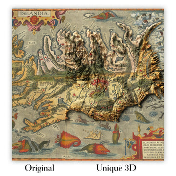
For something truly unique, this map is also available in "Unique 3D", our trademarked process that dramatically transforms the map so that it has a wonderful sense of depth. We combine the original map with detailed topography and elevation data, so that mountains and the terrain really "pop". For more info and examples of 3D maps, check my Unique 3D page.
For most orders, delivery time is about 3 working days. Personalised and customised products take longer, as I have to do the personalisation and send it to you for approval, which usually takes 1 or 2 days.
Please note that very large framed orders usually take longer to make and deliver.
If you need your order to arrive by a certain date, please contact me before you order so that we can find the best way of making sure you get your order in time.
I print and frame maps and artwork in 23 countries around the world. This means your order will be made locally, which cuts down on delivery time and ensures that it won't be damaged during delivery. You'll never pay customs or import duty, and we'll put less CO2 into the air.
All of my maps and art prints are well packaged and sent in a rugged tube if unframed, or surrounded by foam if framed.
I try to send out all orders within 1 or 2 days of receiving your order, though some products (like face masks, mugs and tote bags) can take longer to make.
If you select Express Delivery at checkout your order we will prioritise your order and send it out by 1-day courier (Fedex, DHL, UPS, Parcelforce).
Next Day delivery is also available in some countries (US, UK, Singapore, UAE) but please try to order early in the day so that we can get it sent out on time.
My standard frame is a gallery style black ash hardwood frame. It is simple and quite modern looking. My standard frame is around 20mm (0.8in) wide.
I use super-clear acrylic (perspex/acrylite) for the frame glass. It's lighter and safer than glass - and it looks better, as the reflectivity is lower.
Six standard frame colours are available for free (black, dark brown, dark grey, oak, white and antique gold). Custom framing and mounting/matting is available if you're looking for something else.
Most maps, art and illustrations are also available as a framed canvas. We use matte (not shiny) cotton canvas, stretch it over a sustainably sourced box wood frame, and then 'float' the piece within a wood frame. The end result is quite beautiful, and there's no glazing to get in the way.
All frames are provided "ready to hang", with either a string or brackets on the back. Very large frames will have heavy duty hanging plates and/or a mounting baton. If you have any questions, please get in touch.
See some examples of my framed maps and framed canvas maps.
Alternatively, I can also supply old maps and artwork on canvas, foam board, cotton rag and other materials.
If you want to frame your map or artwork yourself, please read my size guide first.
Alcune delle mie vecchie mappe sono ora disponibili come tele incorniciate. Per favore contattami se desideri ordinare una dimensione che non è disponibile nel mio negozio.
Le vecchie mappe su tela sono un'alternativa interessante alle mappe incorniciate in modo convenzionale. A seconda del tuo gusto personale e dell'arredamento della stanza, le mappe su tela possono "risaltare" un po' di più rispetto a una mappa incorniciata.
My maps are extremely high quality reproductions of original maps.
I source original, rare maps from libraries, auction houses and private collections around the world, restore them at my London workshop, and then use specialist giclée inks and printers to create beautiful maps that look even better than the original.
My maps are printed on acid-free archival matte (not glossy) paper that feels very high quality and almost like card. In technical terms the paper weight/thickness is 10mil/200gsm. It's perfect for framing.
I print with Epson ultrachrome giclée UV fade resistant pigment inks - some of the best inks you can find.
I can also make maps on canvas, cotton rag and other exotic materials.
Learn more about The Unique Maps Co.
Map personalisation
If you're looking for the perfect anniversary or housewarming gift, I can personalise your map to make it truly unique. For example, I can add a short message, or highlight an important location, or add your family's coat of arms.
The options are almost infinite. Please see my map personalisation page for some wonderful examples of what's possible.
To order a personalised map, select "personalise your map" before adding it to your basket.
Get in touch if you're looking for more complex customisations and personalisations.
Map ageing
I have been asked hundreds of times over the years by customers if they could buy a map that looks even older.
Well, now you can, by selecting Aged before you add a map to your basket.
All the product photos you see on this page show the map in its Original form. This is what the map looks like today.
If you select Aged, I will age your map by hand, using a special and unique process developed through years of studying old maps, talking to researchers to understand the chemistry of aging paper, and of course... lots of practice!
If you're unsure, stick to the Original colour of the map. If you want something a bit darker and older looking, go for Aged.
Se non sei soddisfatto del tuo ordine per qualsiasi motivo, contattami per un rimborso senza problemi. Si prega di consultare la nostra politica di reso e rimborso per ulteriori informazioni.
Sono molto sicuro che ti piacerà la tua mappa restaurata o la stampa d'arte. Lo faccio dal 1984. Sono un venditore Etsy a 5 stelle. Ho venduto decine di migliaia di mappe e stampe d'arte e ho oltre 5.000 recensioni reali a 5 stelle.
Utilizzo un processo unico per restaurare mappe e opere d'arte che richiede molto tempo e lavoro. Trovare le mappe e le illustrazioni originali può richiedere mesi. Utilizzo tecnologia all'avanguardia e incredibilmente costosa per scannerizzare e restaurarle. Di conseguenza, garantisco che le mie mappe e stampe d'arte siano superiori alle altre - ecco perché posso offrire un rimborso senza problemi.
Quasi tutte le mie mappe e stampe d'arte sembrano fantastiche a grandi dimensioni (200 cm, 6,5 piedi+) e posso anche incorniciarle e consegnarle a te, tramite un corriere speciale per oggetti di grandi dimensioni. Contattami per discutere delle tue esigenze specifiche.
Or try searching for something!


