


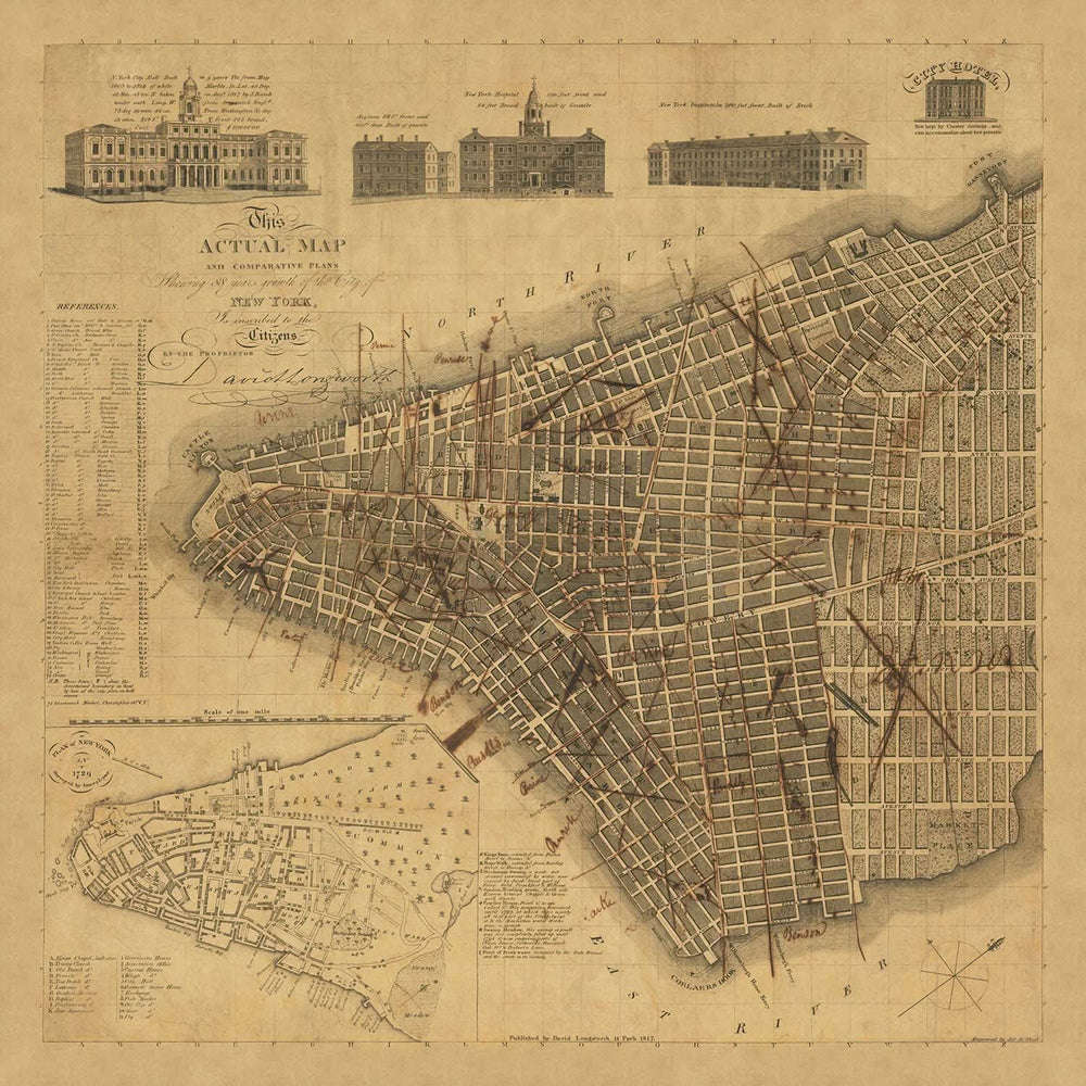


Vecchia mappa di New York di Longworth, 1817: City Hall, Broadway, Wall St, Lower Manhattan
20% di sconto su 2 — 33% di sconto su 3
Aggiungi qualsiasi due articoli idonei al tuo carrello per ricevere 20% di sconto. Aggiungi un terzo e sarà gratuito (equivalente a 33% di sconto quando acquisti tre).
Nessun codice necessario — l'offerta si applica automaticamente al checkout.
Valido su tutte le mappe standard e le stampe d'arte fine. Puoi mescolare e abbinare qualsiasi design.
Se desideri spedire articoli a più indirizzi, ti preghiamo di contattarci prima di effettuare il tuo ordine.
Le commissioni personalizzate e su misura sono escluse.
Contattaci se hai domande
- All taxes and duties included
- Handmade & dispatched in 1-2 days
-
Complimentary gifting & design advice
ⓘ
Complimentary gifting & design advice
Available almost 24/7 on WhatsApp and email — we usually reply within minutes. We can help you:
- Choose a perfectly personalised gift
- Send a digital gift preview to the recipient
- Pick the ideal size for your wall
- Select the right finish and frame
Quick, friendly advice so you can order with confidence.
For last minute gifts, consider buying a digital gift card. We have over 5,000 maps and art prints to choose from.
-
90-day returns & 5-year guarantee
ⓘ
90 giorni per restituire e ricevere un rimborso
I prodotti possono essere restituiti entro 90 giorni per un rimborso completo, o cambio con un altro prodotto.
Per articoli personalizzati e su misura, potremmo offrirti un credito in negozio o una carta regalo non scadente, poiché non possiamo rivendere ordini personalizzati.
Se hai domande, contattaci. Per ulteriori informazioni, consulta la nostra politica di restituzione e cambio.

This is a museum-grade archival print from the original 1817 map — restored in our workshop and made to order on 220gsm archival matte paper or 400gsm artist's cotton canvas with pigment inks.
Professional framing & free personalisation available.
1. Choose a size
2. Frame & personalise your map
Make your map unique with framing, hand-drawn customisation, vintage ageing, pop art text, unique 3D styling and more.


Gift message & custom finish

If you want to add a gift message, or a finish (jigsaw, aluminium board, etc.) that is not available here, please request it in the "order note" when you check out.
Every order is custom made, so if you need the size adjusted slightly, or printed on an unusual material, just let us know. We've done thousands of custom orders over the years, so there's (almost) nothing we can't manage.
You can also contact us before you order, if you prefer!

- Handmade locally. No import duty or tax
- FREE worldwide delivery
- 90-day returns & 5-year product guarantee
- Questions? WhatsApp me any time
Own a piece of history
7,000+ 5 star reviews


"Questa Mappa Attuale e Piani Comparativi che mostrano la crescita della Città di New York negli 88 anni," realizzata dal rinomato David Longworth nel 1817, offre uno sguardo affascinante sull'evoluzione di Lower Manhattan all'inizio del XIX secolo. Questa mappa straordinaria non solo traccia il layout intricato della città strada per strada, ma cattura anche la transizione dinamica da terreni agricoli a espansione urbana. Come una rara e dettagliata rappresentazione di New York City, riflette la crescita e lo sviluppo della metropoli in espansione, rendendola un tesoro per storici e collezionisti.
Le annotazioni dettagliate della mappa suggeriscono che potrebbe aver servito come bozza di lavoro per un'edizione successiva, fornendo spunti sul meticoloso processo di pianificazione urbana e cartografia dell'epoca. Con strutture stradali proposte e piani di urbanizzazione, offre uno sguardo affascinante su come la città fosse concepita e come si sia trasformata nel tempo. L'inclusione di corsi d'acqua che furono presto sepolti o modificati aggiunge un ulteriore livello di intrigante storicità, segnando un momento cruciale nell'evoluzione ambientale e infrastrutturale della città.
La mappa di Longworth è adornata con vignette di luoghi significativi, come il Municipio, l'Ospedale di New York e l'Hotel della Città, che mostrano i successi architettonici del tempo. Queste illustrazioni non solo migliorano l'appeal estetico della mappa, ma fungono anche da indicatori storici delle pietre miliari culturali e civiche di New York. L'inserto del piano di James Lyne del 1729 arricchisce ulteriormente il suo valore storico, offrendo una vista comparativa della crescita della città per quasi un secolo.
I quartieri e le strade meticolosamente tracciati su questa mappa, inclusi Broadway, Wall Street e Pearl Street, forniscono una finestra sulla vita vibrante della New York dei primi tempi. Ogni strada racconta una storia di commercio, comunità e cambiamento, riflettendo il carattere diversificato e dinamico della città. L'attenzione ai dettagli nella denominazione e nella rappresentazione di queste aree sottolinea la sua importanza come documento di storia urbana e trasformazione.
David Longworth, un editore rinomato del suo tempo, ha infuso questa mappa con un senso di coscienza storica e orgoglio civico. Il suo lavoro non solo cattura il layout fisico di New York City, ma incarna anche lo spirito di un'epoca segnata da crescita e innovazione. Questa mappa rimane come testimonianza della dedizione di Longworth a preservare l'eredità di una città che continua a catturare il mondo con la sua ricca storia e cultura vibrante.
Strade e vie su questa mappa
- Ann Street
- Beekman Street
- Broadway
- Canal Street
- Cedar Street
- Chambers Street
- Cherry Street
- Chatham Street
- Division Street
- Dey Street
- Duane Street
- Elizabeth Street
- Fulton Street
- Greenwich Street
- Hudson Street
- Leonard Street
- Liberty Street
- Lispenard Street
- Maiden Lane
- Mercer Street
- Nassau Street
- Pearl Street
- Pine Street
- Prince Street
- Reade Street
- Spring Street
- Wall Street
- Warren Street
- Water Street
- Worth Street
Caratteristiche e Luoghi Notabili
- Mappe in insetto:
- Piano di James Lyne di New York City (1729) in basso a sinistra
- Illustrazioni:
- Municipio
- Ospedale di New York
- Istituzione di New York
- Hotel della Città
Contesto storico e di design
- Nome della mappa: Questa mappa attuale e i piani comparativi mostrano la crescita della città di New York negli ultimi 88 anni
- Data di creazione: 1817
- Cartografo/Editore: David Longworth
- Argomenti e temi:
- Disposizione di Lower Manhattan all'inizio del XIX secolo
- Rappresentazione della città strada per strada
- Strutture stradali proposte e urbanizzazione
- Fiumi presto sepolti o modificati
- Design/Stile:
- Annotazioni estese, possibilmente una bozza di lavoro per una seconda edizione
- Riflette l'urbanizzazione e la coscienza storica della città di New York
Si prega di controllare attentamente le immagini per assicurarsi che una specifica città o luogo sia mostrato su questa mappa. Puoi anche contattarci e chiedere di controllare la mappa per te.
Questa mappa appare fantastica in ogni dimensione, ma consiglio sempre di optare per una dimensione più grande se hai spazio. In questo modo puoi facilmente distinguere tutti i dettagli.
Questa mappa appare incredibile in dimensioni fino a 90 pollici (230 cm). Se stai cercando una mappa più grande, ti prego di contattarci.
Il modello nelle immagini dell'elenco tiene in mano la versione 16x16 pollici (40x40 cm) di questa mappa.
La quinta immagine dell'elenco mostra un esempio del mio servizio di personalizzazione della mappa.
Se stai cercando qualcosa di leggermente diverso, dai un'occhiata alla mia collezione delle migliori mappe antiche per vedere se qualcosa attira la tua attenzione.
Per favore, contattami per verificare se una certa posizione, un punto di riferimento o una caratteristica è mostrata su questa mappa.
Questo sarebbe un meraviglioso regalo per un compleanno, Natale, Festa del Papà, una partenza dal lavoro, un anniversario o una festa di inaugurazione per qualcuno delle aree coperte da questa mappa.
Questa mappa è disponibile come stampa giclée su carta opaca archiviata senza acidi, oppure puoi acquistarla incorniciata. La cornice è una semplice cornice nera che si adatta alla maggior parte degli stili. Per favore, contattami se desideri un colore o un materiale di cornice diverso. Le mie cornici sono dotate di acrilico super chiaro di qualità museale (perspex/acrylite), che è significativamente meno riflettente del vetro, più sicuro e arriverà sempre in perfette condizioni.
This map is also available as a float framed canvas, sometimes known as a shadow gap framed canvas or canvas floater. The map is printed on artist's cotton canvas and then stretched over a handmade box frame. We then "float" the canvas inside a wooden frame, which is available in a range of colours (black, dark brown, oak, antique gold and white). This is a wonderful way to present a map without glazing in front. See some examples of float framed canvas maps and explore the differences between my different finishes.
For something truly unique, this map is also available in "Unique 3D", our trademarked process that dramatically transforms the map so that it has a wonderful sense of depth. We combine the original map with detailed topography and elevation data, so that mountains and the terrain really "pop". For more info and examples of 3D maps, check my Unique 3D page.
For most orders, delivery time is about 3 working days. Personalised and customised products take longer, as I have to do the personalisation and send it to you for approval, which usually takes 1 or 2 days.
Please note that very large framed orders usually take longer to make and deliver.
If you need your order to arrive by a certain date, please contact me before you order so that we can find the best way of making sure you get your order in time.
I print and frame maps and artwork in 23 countries around the world. This means your order will be made locally, which cuts down on delivery time and ensures that it won't be damaged during delivery. You'll never pay customs or import duty, and we'll put less CO2 into the air.
All of my maps and art prints are well packaged and sent in a rugged tube if unframed, or surrounded by foam if framed.
I try to send out all orders within 1 or 2 days of receiving your order, though some products (like face masks, mugs and tote bags) can take longer to make.
If you select Express Delivery at checkout your order we will prioritise your order and send it out by 1-day courier (Fedex, DHL, UPS, Parcelforce).
Next Day delivery is also available in some countries (US, UK, Singapore, UAE) but please try to order early in the day so that we can get it sent out on time.
My standard frame is a gallery style black ash hardwood frame. It is simple and quite modern looking. My standard frame is around 20mm (0.8in) wide.
I use super-clear acrylic (perspex/acrylite) for the frame glass. It's lighter and safer than glass - and it looks better, as the reflectivity is lower.
Six standard frame colours are available for free (black, dark brown, dark grey, oak, white and antique gold). Custom framing and mounting/matting is available if you're looking for something else.
Most maps, art and illustrations are also available as a framed canvas. We use matte (not shiny) cotton canvas, stretch it over a sustainably sourced box wood frame, and then 'float' the piece within a wood frame. The end result is quite beautiful, and there's no glazing to get in the way.
All frames are provided "ready to hang", with either a string or brackets on the back. Very large frames will have heavy duty hanging plates and/or a mounting baton. If you have any questions, please get in touch.
See some examples of my framed maps and framed canvas maps.
Alternatively, I can also supply old maps and artwork on canvas, foam board, cotton rag and other materials.
If you want to frame your map or artwork yourself, please read my size guide first.
Alcune delle mie vecchie mappe sono ora disponibili come tele incorniciate. Per favore contattami se desideri ordinare una dimensione che non è disponibile nel mio negozio.
Le vecchie mappe su tela sono un'alternativa interessante alle mappe incorniciate in modo convenzionale. A seconda del tuo gusto personale e dell'arredamento della stanza, le mappe su tela possono "risaltare" un po' di più rispetto a una mappa incorniciata.
My maps are extremely high quality reproductions of original maps.
I source original, rare maps from libraries, auction houses and private collections around the world, restore them at my London workshop, and then use specialist giclée inks and printers to create beautiful maps that look even better than the original.
My maps are printed on acid-free archival matte (not glossy) paper that feels very high quality and almost like card. In technical terms the paper weight/thickness is 10mil/200gsm. It's perfect for framing.
I print with Epson ultrachrome giclée UV fade resistant pigment inks - some of the best inks you can find.
I can also make maps on canvas, cotton rag and other exotic materials.
Learn more about The Unique Maps Co.
Map personalisation
If you're looking for the perfect anniversary or housewarming gift, I can personalise your map to make it truly unique. For example, I can add a short message, or highlight an important location, or add your family's coat of arms.
The options are almost infinite. Please see my map personalisation page for some wonderful examples of what's possible.
To order a personalised map, select "personalise your map" before adding it to your basket.
Get in touch if you're looking for more complex customisations and personalisations.
Map ageing
I have been asked hundreds of times over the years by customers if they could buy a map that looks even older.
Well, now you can, by selecting Aged before you add a map to your basket.
All the product photos you see on this page show the map in its Original form. This is what the map looks like today.
If you select Aged, I will age your map by hand, using a special and unique process developed through years of studying old maps, talking to researchers to understand the chemistry of aging paper, and of course... lots of practice!
If you're unsure, stick to the Original colour of the map. If you want something a bit darker and older looking, go for Aged.
Se non sei soddisfatto del tuo ordine per qualsiasi motivo, contattami per un rimborso senza problemi. Si prega di consultare la nostra politica di reso e rimborso per ulteriori informazioni.
Sono molto sicuro che ti piacerà la tua mappa restaurata o la stampa d'arte. Lo faccio dal 1984. Sono un venditore Etsy a 5 stelle. Ho venduto decine di migliaia di mappe e stampe d'arte e ho oltre 5.000 recensioni reali a 5 stelle.
Utilizzo un processo unico per restaurare mappe e opere d'arte che richiede molto tempo e lavoro. Trovare le mappe e le illustrazioni originali può richiedere mesi. Utilizzo tecnologia all'avanguardia e incredibilmente costosa per scannerizzare e restaurarle. Di conseguenza, garantisco che le mie mappe e stampe d'arte siano superiori alle altre - ecco perché posso offrire un rimborso senza problemi.
Quasi tutte le mie mappe e stampe d'arte sembrano fantastiche a grandi dimensioni (200 cm, 6,5 piedi+) e posso anche incorniciarle e consegnarle a te, tramite un corriere speciale per oggetti di grandi dimensioni. Contattami per discutere delle tue esigenze specifiche.
Or try searching for something!


