


Mappa Pictoriale Antica di Pechino di Dorn, 1936: Città Proibita, Tempio del Cielo, Palazzo d'Estate, Tombe Ming, Grande Muraglia
- All taxes and duties included
- Handmade & dispatched in 1-2 days
-
90 day money back guarantee
ⓘ
90 giorni per restituire e ricevere un rimborso
I prodotti possono essere restituiti entro 90 giorni per un rimborso completo, o cambio con un altro prodotto.
Per articoli personalizzati e su misura, potremmo offrirti un credito in negozio o una carta regalo non scadente, poiché non possiamo rivendere ordini personalizzati.
Se hai domande, contattaci. Per ulteriori informazioni, consulta la nostra politica di restituzione e cambio.

My maps are rare, museum-grade, restored old maps sourced from libraries, auction houses and private collections across the globe.
Framing & free personalisation available
1. Select your size
2. Frame & personalise your map
There is limited framing & personalisation capacity available. Order by 10am tomorrow for Christmas delivery.


Gift message & custom finish

If you want to add a gift message, or a finish (jigsaw, aluminium board, etc.) that is not available here, please request it in the "order note" when you check out.
Every order is custom made, so if you need the size adjusted slightly, or printed on an unusual material, just let us know. We've done thousands of custom orders over the years, so there's (almost) nothing we can't manage.
You can also contact us before you order, if you prefer!

- Handmade locally. No import duty or tax
- FREE Delivery by Christmas
- Love it or your money back (90 days)
- Questions? WhatsApp me any time
Own a piece of history
5,000+ 5 star reviews


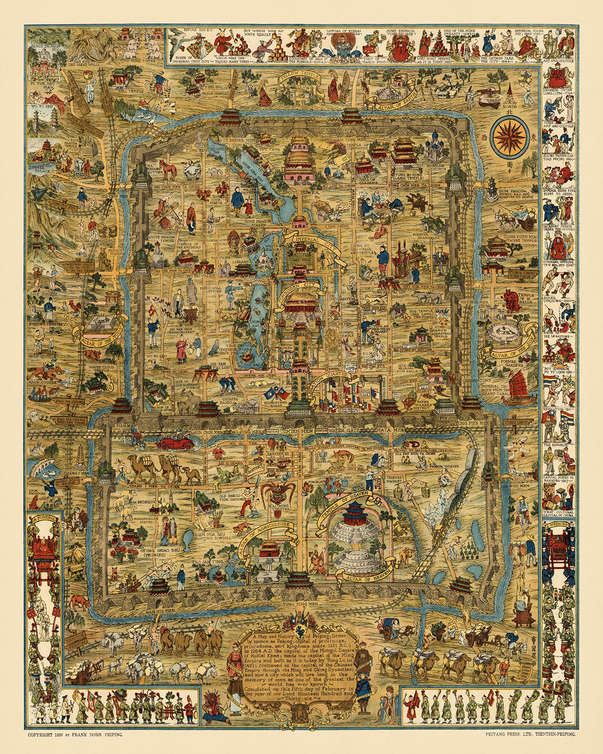
Entra nella vibrante storia di Pechino con il capolavoro illustrato con cura del 1936 di Frank Dorn, "Una Mappa e Storia di Peiping (Pechino)." Questa mappa è una festa visiva, adornata con ricchi vignettes a colori che catturano l'essenza del patrimonio culturale e storico di Pechino. Ogni angolo di questa mappa è colmo di scene di vita quotidiana, monumenti storici ed eventi significativi, offrendo un ritratto dettagliato e coinvolgente della città così com'era negli anni '30. L'arte e l'attenzione ai dettagli rendono questa mappa non solo uno strumento di navigazione ma un'opera d'arte che racconta la storia di una delle città più storiche del mondo.
Frank Dorn, un artista e ufficiale militare americano, porta la sua prospettiva unica e il suo talento artistico in questa mappa, creando un'opera che è sia informativa che visivamente sorprendente. Il background di Dorn nell'esercito e i suoi talenti artistici si uniscono per fornire una rappresentazione completa e esteticamente piacevole di Pechino. La sua mappa non è solo una rappresentazione geografica ma un documento storico che cattura lo spirito e la cultura della città durante un periodo di cambiamenti e sviluppi significativi.
La mappa mette in evidenza alcuni dei monumenti più iconici di Pechino, tra cui la Città Proibita, il Tempio del Cielo e il Palazzo d'Estate. Questi luoghi, intrisi di storia e significato culturale, sono splendidamente illustrati e etichettati, rendendoli facilmente identificabili. L'inclusione della Grande Muraglia Cinese, delle Tombe Ming e di vari portoni della città come Deshengmen e Andingmen arricchisce ulteriormente il contesto storico della mappa. Ogni monumento è rappresentato con meticolosa attenzione ai dettagli, riflettendo la sua importanza nel tessuto culturale e storico di Pechino.
Oltre al suo focus sui monumenti, la mappa offre anche uno sguardo nella vita quotidiana e nelle attività dei residenti di Pechino. Scene di mercati, venditori di strada e teatro e opera tradizionali cinesi sono disseminate in tutta la mappa, offrendo un ritratto vivido della vibrante cultura della città. La rappresentazione delle attività agricole, dei festival religiosi e dei vari templi e santuari aggiunge profondità alla mappa, mostrando la natura diversificata e sfaccettata della vita a Pechino negli anni '30.
Questa mappa non è solo un artefatto storico ma una celebrazione del ricco patrimonio di Pechino. Serve come una risorsa preziosa per storici, collezionisti e chiunque abbia interesse nella storia e nella cultura di una delle città più antiche e affascinanti del mondo. La combinazione di illustrazioni dettagliate, accuratezza storica e bellezza artistica rende "Una Mappa e Storia di Peiping (Pechino)" di Frank Dorn un pezzo davvero eccezionale che cattura l'essenza di Pechino in un modo che poche altre mappe possono.
Luoghi su questa mappa
- La Città Proibita
- Il Tempio del Cielo
- Il Palazzo d'Estate
- Le Tombe Ming
- La Torre della Campana
- La Torre del Tamburo
- Il Tempio dei Lama
- La Città Imperiale
- Il Quartiere delle Legazioni
- Il Ponte di Marco Polo
- Il Gran Canale
- Porta Deshengmen
- Porta Andingmen
- Lo Zoo di Pechino
- Il Vecchio Osservatorio
- La Sala dell'Armonia Suprema
- La Sala della Preghiera per Buoni Raccolti
- Il Muro dei Nove Draghi
- Il Dagoba Bianco
- L'Isola di Giada
Caratteristiche e Monumenti Notabili
- La Grande Muraglia Cinese
- La Città Proibita
- Il Tempio del Cielo
- Il Palazzo d'Estate
- Le Tombe Ming
- La Torre della Campana
- La Torre del Tamburo
- Il Tempio del Lama
- La Città Imperiale
- Il Quartiere delle Legazioni
- Il Ponte Marco Polo
- Il Grande Canale
- Varie porte della città (es. Deshengmen, Andingmen)
- Lo Zoo di Pechino
- Il Vecchio Osservatorio
- La Sala della Suprema Armonia
- La Sala delle Preghiere per Buoni Raccolti
- Il Muro dei Nove Draghi
- Il Dagoba Bianco
- L'Isola di Giada
- Le Mura della Città Vecchia
- Scene di vita quotidiana, inclusi mercati e venditori di strada
- Eventi storici e scene, come battaglie e cerimonie
- Varie templi e santuari
- Rappresentazioni dell'architettura tradizionale cinese
- Illustrazioni di animali, inclusi draghi e tigri
- Vie d'acqua e ponti all'interno della città
- Attività agricole e vita rurale
- Festival culturali e religiosi
- Scene di teatro e opera cinese tradizionali
- Illustrazioni del folklore e delle leggende cinesi
Contesto storico e di design
- Nome della mappa: Una Mappa e Storia di Peiping (Pechino)
- Note extra:
- Questa è una mappa elaboratamente illustrata.
- Include vignette di dozzine di luoghi, animali, attività umane e scene storiche con etichette.
- La mappa è a colori.
- Data di creazione: 1936
- Cartografo/Editore: Frank Dorn
- Frank Dorn era un artista e ufficiale militare americano noto per le sue mappe dettagliate e artistiche.
- Argomenti e temi:
- La mappa si concentra sugli aspetti storici e culturali di Pechino (Peiping), Cina.
- Presenta eventi storici, monumenti e vita quotidiana a Pechino.
- Paesi e regioni mostrati:
- La mappa rappresenta principalmente la città di Pechino (Peiping), Cina.
- Design/Stile:
- La mappa è altamente decorativa e pittorica, con illustrazioni ricche e colori vivaci.
- Include vignette dettagliate ed etichette per vari luoghi e attività.
- Significato storico:
- La mappa fornisce un'istantanea storica di Pechino negli anni '30, evidenziando il suo patrimonio culturale e storico.
- Serve come una risorsa preziosa per comprendere la disposizione della città e i monumenti significativi durante quel periodo.
Si prega di controllare le immagini per assicurarsi che una città o un luogo specifico sia mostrato su questa mappa. Puoi anche contattarci e chiedere di controllare la mappa per te.
Questa mappa appare fantastica in ogni dimensione, ma consiglio sempre di optare per una dimensione più grande se hai spazio. In questo modo puoi facilmente distinguere tutti i dettagli.
Questa mappa appare incredibile in dimensioni fino a 100in (250cm). Se stai cercando una mappa più grande, per favore contattaci.
Il modello nelle immagini dell'inserzione sta tenendo la versione della mappa 16x20in (40x50cm).
La quinta immagine dell'inserzione mostra un esempio del mio servizio di personalizzazione della mappa.
Se stai cercando qualcosa di leggermente diverso, dai un'occhiata alla mia collezione delle migliori vecchie mappe per vedere se qualcosa attira la tua attenzione.
Si prega di contattarmi per verificare se una certa posizione, monumento o caratteristica è mostrata su questa mappa.
Questo sarebbe un regalo meraviglioso per un compleanno, Natale, Festa del Papà, pensionamento, anniversario o inaugurazione della casa per qualcuno delle aree coperte da questa mappa.
Questa mappa è disponibile come stampa giclée su carta opaca archiviabile senza acidi, oppure puoi acquistarla incorniciata. La cornice è una semplice cornice nera che si adatta alla maggior parte degli stili. Ti preghiamo di contattarci se desideri un colore o un materiale diverso per la cornice. Le mie cornici sono dotate di un vetro acrilico di alta qualità super chiaro (perspex/acrylite), che è significativamente meno riflettente del vetro, più sicuro e arriverà sempre in perfette condizioni.
This map is also available as a float framed canvas, sometimes known as a shadow gap framed canvas or canvas floater. The map is printed on artist's cotton canvas and then stretched over a handmade box frame. We then "float" the canvas inside a wooden frame, which is available in a range of colours (black, dark brown, oak, antique gold and white). This is a wonderful way to present a map without glazing in front. See some examples of float framed canvas maps and explore the differences between my different finishes.
For something truly unique, this map is also available in "Unique 3D", our trademarked process that dramatically transforms the map so that it has a wonderful sense of depth. We combine the original map with detailed topography and elevation data, so that mountains and the terrain really "pop". For more info and examples of 3D maps, check my Unique 3D page.
For most orders, delivery time is about 3 working days. Personalised and customised products take longer, as I have to do the personalisation and send it to you for approval, which usually takes 1 or 2 days.
Please note that very large framed orders usually take longer to make and deliver.
If you need your order to arrive by a certain date, please contact me before you order so that we can find the best way of making sure you get your order in time.
I print and frame maps and artwork in 23 countries around the world. This means your order will be made locally, which cuts down on delivery time and ensures that it won't be damaged during delivery. You'll never pay customs or import duty, and we'll put less CO2 into the air.
All of my maps and art prints are well packaged and sent in a rugged tube if unframed, or surrounded by foam if framed.
I try to send out all orders within 1 or 2 days of receiving your order, though some products (like face masks, mugs and tote bags) can take longer to make.
If you select Express Delivery at checkout your order we will prioritise your order and send it out by 1-day courier (Fedex, DHL, UPS, Parcelforce).
Next Day delivery is also available in some countries (US, UK, Singapore, UAE) but please try to order early in the day so that we can get it sent out on time.
My standard frame is a gallery style black ash hardwood frame. It is simple and quite modern looking. My standard frame is around 20mm (0.8in) wide.
I use super-clear acrylic (perspex/acrylite) for the frame glass. It's lighter and safer than glass - and it looks better, as the reflectivity is lower.
Six standard frame colours are available for free (black, dark brown, dark grey, oak, white and antique gold). Custom framing and mounting/matting is available if you're looking for something else.
Most maps, art and illustrations are also available as a framed canvas. We use matte (not shiny) cotton canvas, stretch it over a sustainably sourced box wood frame, and then 'float' the piece within a wood frame. The end result is quite beautiful, and there's no glazing to get in the way.
All frames are provided "ready to hang", with either a string or brackets on the back. Very large frames will have heavy duty hanging plates and/or a mounting baton. If you have any questions, please get in touch.
See some examples of my framed maps and framed canvas maps.
Alternatively, I can also supply old maps and artwork on canvas, foam board, cotton rag and other materials.
If you want to frame your map or artwork yourself, please read my size guide first.
Alcune delle mie vecchie mappe sono ora disponibili come tele incorniciate. Per favore contattami se desideri ordinare una dimensione che non è disponibile nel mio negozio.
Le vecchie mappe su tela sono un'alternativa interessante alle mappe incorniciate in modo convenzionale. A seconda del tuo gusto personale e dell'arredamento della stanza, le mappe su tela possono "risaltare" un po' di più rispetto a una mappa incorniciata.
My maps are extremely high quality reproductions of original maps.
I source original, rare maps from libraries, auction houses and private collections around the world, restore them at my London workshop, and then use specialist giclée inks and printers to create beautiful maps that look even better than the original.
My maps are printed on acid-free archival matte (not glossy) paper that feels very high quality and almost like card. In technical terms the paper weight/thickness is 10mil/200gsm. It's perfect for framing.
I print with Epson ultrachrome giclée UV fade resistant pigment inks - some of the best inks you can find.
I can also make maps on canvas, cotton rag and other exotic materials.
Learn more about The Unique Maps Co.
Map personalisation
If you're looking for the perfect anniversary or housewarming gift, I can personalise your map to make it truly unique. For example, I can add a short message, or highlight an important location, or add your family's coat of arms.
The options are almost infinite. Please see my map personalisation page for some wonderful examples of what's possible.
To order a personalised map, select "personalise your map" before adding it to your basket.
Get in touch if you're looking for more complex customisations and personalisations.
Map ageing
I have been asked hundreds of times over the years by customers if they could buy a map that looks even older.
Well, now you can, by selecting Aged before you add a map to your basket.
All the product photos you see on this page show the map in its Original form. This is what the map looks like today.
If you select Aged, I will age your map by hand, using a special and unique process developed through years of studying old maps, talking to researchers to understand the chemistry of aging paper, and of course... lots of practice!
If you're unsure, stick to the Original colour of the map. If you want something a bit darker and older looking, go for Aged.
Se non sei soddisfatto del tuo ordine per qualsiasi motivo, contattami per un rimborso senza problemi. Si prega di consultare la nostra politica di reso e rimborso per ulteriori informazioni.
Sono molto sicuro che ti piacerà la tua mappa restaurata o la stampa d'arte. Lo faccio dal 1984. Sono un venditore Etsy a 5 stelle. Ho venduto decine di migliaia di mappe e stampe d'arte e ho oltre 5.000 recensioni reali a 5 stelle.
Utilizzo un processo unico per restaurare mappe e opere d'arte che richiede molto tempo e lavoro. Trovare le mappe e le illustrazioni originali può richiedere mesi. Utilizzo tecnologia all'avanguardia e incredibilmente costosa per scannerizzare e restaurarle. Di conseguenza, garantisco che le mie mappe e stampe d'arte siano superiori alle altre - ecco perché posso offrire un rimborso senza problemi.
Quasi tutte le mie mappe e stampe d'arte sembrano fantastiche a grandi dimensioni (200 cm, 6,5 piedi+) e posso anche incorniciarle e consegnarle a te, tramite un corriere speciale per oggetti di grandi dimensioni. Contattami per discutere delle tue esigenze specifiche.
Or try searching for something!


