


Mappa antica massiccia dell'Europa di Visscher, 1677: Alleanza Tripla, Vedute delle città capitali
- All taxes and duties included
- Handmade & dispatched in 1-2 days
-
90 day money back guarantee
ⓘ
90 giorni per restituire e ricevere un rimborso
I prodotti possono essere restituiti entro 90 giorni per un rimborso completo, o cambio con un altro prodotto.
Per articoli personalizzati e su misura, potremmo offrirti un credito in negozio o una carta regalo non scadente, poiché non possiamo rivendere ordini personalizzati.
Se hai domande, contattaci. Per ulteriori informazioni, consulta la nostra politica di restituzione e cambio.

My maps are rare, museum-grade, restored old maps sourced from libraries, auction houses and private collections across the globe.
Framing & free personalisation available
1. Select your size
2. Frame & personalise your map
There is limited framing & personalisation capacity available. Order by 10am tomorrow for Christmas delivery.


Gift message & custom finish

If you want to add a gift message, or a finish (jigsaw, aluminium board, etc.) that is not available here, please request it in the "order note" when you check out.
Every order is custom made, so if you need the size adjusted slightly, or printed on an unusual material, just let us know. We've done thousands of custom orders over the years, so there's (almost) nothing we can't manage.
You can also contact us before you order, if you prefer!

- Handmade locally. No import duty or tax
- FREE Delivery by Christmas
- Love it or your money back (90 days)
- Questions? WhatsApp me any time
Own a piece of history
5,000+ 5 star reviews


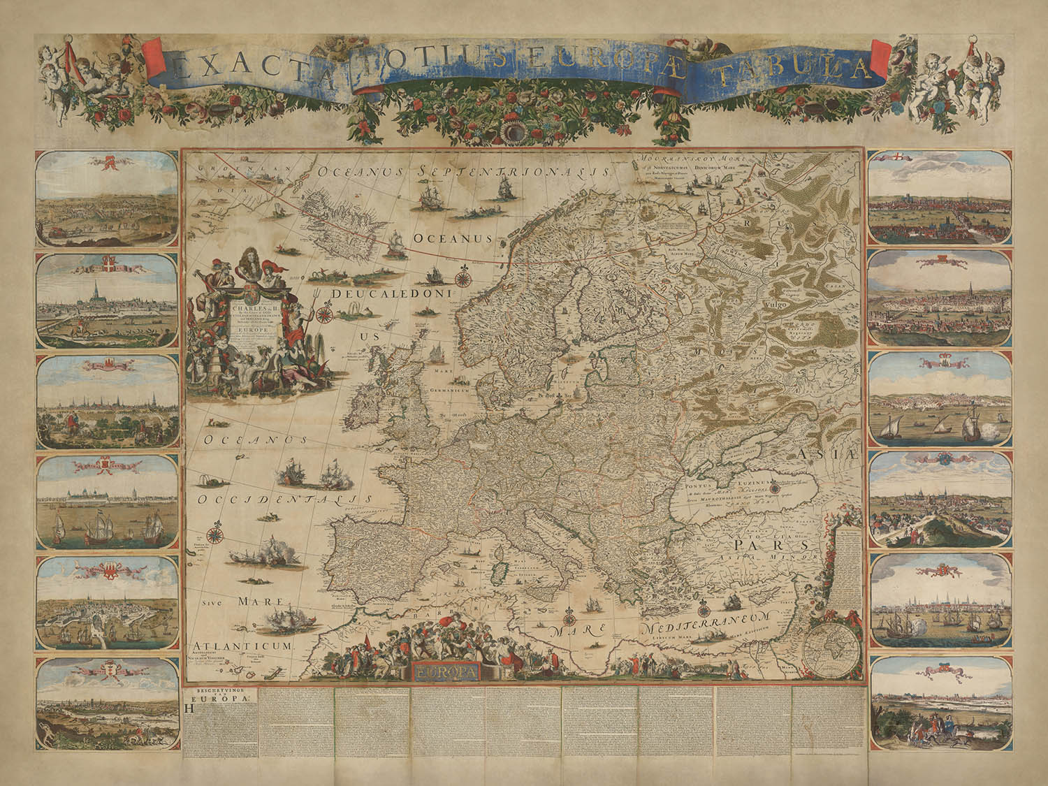
Entra nel 17° secolo con la "Exacta Totius Europae Tabula" di Nicolaes Visscher II, una straordinaria mappa murale che cattura magistralmente la geografia politica e fisica dell'Europa durante un momento cruciale della storia. Creata nel 1677, questa mappa commemora la formazione della Triplice Alleanza tra i Paesi Bassi, la Svezia e l'Inghilterra—una coalizione di breve durata ma significativa che ha plasmato l'equilibrio di potere in Europa. Dedicata al re Carlo II d'Inghilterra, la mappa celebra questo traguardo diplomatico, sottolineando l'unità di queste nazioni contro minacce comuni e ponendo le basi per future alleanze.
Il genio artistico di Visscher è in piena mostra in questa mappa, che fonde precisione cartografica con elaborati elementi decorativi. Il focus centrale della mappa è una rappresentazione dettagliata dell'Europa, con coste, fiumi e catene montuose disegnati meticolosamente. Attorno alla mappa ci sono vivaci illustrazioni allegoriche, tra cui un ritratto del re Carlo II, scene marittime e rappresentazioni simboliche di unità e potere. Questi abbellimenti elevano la mappa da strumento pratico a opera d'arte, riflettendo la grandezza e le aspirazioni del suo tempo.
Il design della mappa è una testimonianza della reputazione della famiglia Visscher per l'eccellenza nella cartografia. Nicolaes Visscher II, seguendo le orme di suo padre e di suo nonno, ha infuso questa mappa sia di accuratezza scientifica che di flair artistico. La proiezione cartografica mostra la geografia dell'Europa con straordinaria chiarezza, mentre l'inclusione di vedute delle città e annotazioni fornisce un ricco contesto storico. Questo duplice focus su estetica e informazione esemplifica il Secolo d'Oro olandese della cartografia, un periodo in cui le mappe erano tanto racconti quanto strumenti di navigazione.
Oltre ai suoi dettagli geografici, la mappa funge da documento storico, offrendo spunti sulle dinamiche politiche della fine del 17° secolo. La Triplice Alleanza, formata per contrastare le ambizioni espansionistiche della Francia, è un tema centrale, simboleggiato attraverso la dedica della mappa e le immagini allegoriche. La dissoluzione eventuale dell'alleanza e la successiva guerra franco-olandese evidenziano la fluidità della politica europea, rendendo questa mappa un'istantanea di un momento fugace ma trasformativo nella storia.
Questa mappa non è semplicemente una rappresentazione di terra e mare, ma una celebrazione del paesaggio culturale e politico dell'Europa. Le illustrazioni circostanti delle principali città—come Londra, Parigi e Amsterdam—catturano lo splendore architettonico e l'importanza di questi centri urbani. Navi che punteggiano gli oceani e i mari evocano il dominio marittimo dell'epoca, mentre i cartigli e i banner ornate aggiungono un livello di eleganza regale. La "Exacta Totius Europae Tabula" di Nicolaes Visscher II è un capolavoro che trascende il suo scopo cartografico, offrendo una finestra sull'arte, la storia e la diplomazia di un'epoca passata.
Paesi e regioni su questa mappa
- Continenti:
- Europa (focus centrale).
- Parti dell'Asia (regioni occidentali).
- Nord Africa (aree costiere).
- Paesi e regioni:
- Inghilterra, Scozia, Irlanda.
- Francia, Spagna, Portogallo.
- I Paesi Bassi, Belgio.
- Germania, Austria, Svizzera.
- Italia e gli stati italiani.
- Polonia, Lituania.
- Svezia, Norvegia, Danimarca.
- Russia (parti occidentali).
- Impero Ottomano (territori europei).
- Ungheria, Boemia.
- Regioni balcaniche.
- Grecia e isole circostanti.
Caratteristiche e monumenti notevoli
- Illustrazioni in evidenza:
- Rappresentazioni di città europee prominenti, inclusi i loro monumenti architettonici e culturali.
- Città come Londra, Parigi e Amsterdam sono evidenziate.
- Corpi idrici:
- Principali mari e oceani, inclusi l'oceano Atlantico, il mare Mediterraneo e il mare Baltico.
- Corpi idrici più piccoli, inclusi mari e baie regionali.
- Catene montuose:
- Principali catene montuose europee, come le Alpi e i Carpazi, sono illustrate con rilievo stilizzato.
- Elementi decorativi:
- Figure e simboli allegorici che celebrano la Triplice Alleanza.
- Cartigli e banner ornati, incluso uno con il titolo della mappa.
- Illustrazioni di navi nei mari, evidenziando l'attività marittima.
- Note storiche e annotazioni:
- Blocchi di testo nella parte inferiore della mappa forniscono contesto storico e geografico.
- Dedica al re Carlo II e riferimenti alla Triplice Alleanza.
- Altre caratteristiche:
- Coste e fiumi dettagliati.
- Rappresentazioni di scontri navali o flotte, riflettendo l'importanza del potere marittimo.
Contesto storico e di design
- Significato storico:
- Creato nel 1677 per commemorare la Triplice Alleanza (1668–1672) tra i Paesi Bassi, la Svezia e l'Inghilterra.
- Dedica al re Carlo II d'Inghilterra, enfatizzando l'importanza dell'alleanza per l'Inghilterra e i suoi vicini europei.
- L'alleanza fu un precursore della Grande Alleanza, che combatté guerre europee importanti come la Guerra dei Nove Anni (1688–1697) e la Guerra di Successione Spagnola (1701–1714).
- Temi e argomenti:
- Geografia politica e fisica dell'Europa durante il XVII secolo.
- Region marittime e costiere, riflettendo l'importanza del potere navale e delle rotte commerciali.
- Design e stile:
- Decorato con illustrazioni allegoriche e simboliche.
- Vista vivaci delle città e illustrazioni dei principali centri urbani europei.
- Combina precisione cartografica con un tocco artistico, esemplificando il periodo d'oro della cartografia olandese.
- Include un ritratto del re Carlo II e immagini allegoriche che simboleggiano unità e potere.
Si prega di controllare le immagini per assicurarsi che una specifica città o luogo sia mostrato su questa mappa. Puoi anche contattarci e chiedere di controllare la mappa per te.
Questa è una mappa molto grande che deve essere ordinata in grande formato, in modo da poter facilmente distinguere tutti i dettagli.
Questa mappa appare fantastica in dimensioni fino a 100 pollici (250 cm). Se stai cercando una mappa più grande, per favore contattaci.
Il modello nelle immagini dell'inserzione sta tenendo la versione 18x24 pollici (45x60 cm) di questa mappa.
La quinta immagine dell'inserzione mostra un esempio del mio servizio di personalizzazione della mappa.
Se stai cercando qualcosa di leggermente diverso, dai un'occhiata alla mia collezione dei migliori mappe antiche per vedere se qualcosa colpisce la tua attenzione.
Per favore contattami per verificare se una certa posizione, punto di riferimento o caratteristica è mostrata su questa mappa.
Questo sarebbe un meraviglioso regalo per un compleanno, Natale, Festa del Papà, un congedo dal lavoro, un anniversario o un regalo per una nuova casa per qualcuno delle aree coperte da questa mappa.
Questa mappa è disponibile come stampa giclée su carta opaca archivistica senza acidi, oppure puoi acquistarla incorniciata. La cornice è una bella e semplice cornice nera che si adatta alla maggior parte degli stili. Per favore, contattami se desideri un colore o un materiale di cornice diverso. Le mie cornici sono rivestite con acrilico super chiaro di grado museale (perspex/acrylite), che è significativamente meno riflettente del vetro, più sicuro e arriverà sempre in perfette condizioni.
This map is also available as a float framed canvas, sometimes known as a shadow gap framed canvas or canvas floater. The map is printed on artist's cotton canvas and then stretched over a handmade box frame. We then "float" the canvas inside a wooden frame, which is available in a range of colours (black, dark brown, oak, antique gold and white). This is a wonderful way to present a map without glazing in front. See some examples of float framed canvas maps and explore the differences between my different finishes.
For something truly unique, this map is also available in "Unique 3D", our trademarked process that dramatically transforms the map so that it has a wonderful sense of depth. We combine the original map with detailed topography and elevation data, so that mountains and the terrain really "pop". For more info and examples of 3D maps, check my Unique 3D page.
For most orders, delivery time is about 3 working days. Personalised and customised products take longer, as I have to do the personalisation and send it to you for approval, which usually takes 1 or 2 days.
Please note that very large framed orders usually take longer to make and deliver.
If you need your order to arrive by a certain date, please contact me before you order so that we can find the best way of making sure you get your order in time.
I print and frame maps and artwork in 23 countries around the world. This means your order will be made locally, which cuts down on delivery time and ensures that it won't be damaged during delivery. You'll never pay customs or import duty, and we'll put less CO2 into the air.
All of my maps and art prints are well packaged and sent in a rugged tube if unframed, or surrounded by foam if framed.
I try to send out all orders within 1 or 2 days of receiving your order, though some products (like face masks, mugs and tote bags) can take longer to make.
If you select Express Delivery at checkout your order we will prioritise your order and send it out by 1-day courier (Fedex, DHL, UPS, Parcelforce).
Next Day delivery is also available in some countries (US, UK, Singapore, UAE) but please try to order early in the day so that we can get it sent out on time.
My standard frame is a gallery style black ash hardwood frame. It is simple and quite modern looking. My standard frame is around 20mm (0.8in) wide.
I use super-clear acrylic (perspex/acrylite) for the frame glass. It's lighter and safer than glass - and it looks better, as the reflectivity is lower.
Six standard frame colours are available for free (black, dark brown, dark grey, oak, white and antique gold). Custom framing and mounting/matting is available if you're looking for something else.
Most maps, art and illustrations are also available as a framed canvas. We use matte (not shiny) cotton canvas, stretch it over a sustainably sourced box wood frame, and then 'float' the piece within a wood frame. The end result is quite beautiful, and there's no glazing to get in the way.
All frames are provided "ready to hang", with either a string or brackets on the back. Very large frames will have heavy duty hanging plates and/or a mounting baton. If you have any questions, please get in touch.
See some examples of my framed maps and framed canvas maps.
Alternatively, I can also supply old maps and artwork on canvas, foam board, cotton rag and other materials.
If you want to frame your map or artwork yourself, please read my size guide first.
Alcune delle mie vecchie mappe sono ora disponibili come tele incorniciate. Per favore contattami se desideri ordinare una dimensione che non è disponibile nel mio negozio.
Le vecchie mappe su tela sono un'alternativa interessante alle mappe incorniciate in modo convenzionale. A seconda del tuo gusto personale e dell'arredamento della stanza, le mappe su tela possono "risaltare" un po' di più rispetto a una mappa incorniciata.
My maps are extremely high quality reproductions of original maps.
I source original, rare maps from libraries, auction houses and private collections around the world, restore them at my London workshop, and then use specialist giclée inks and printers to create beautiful maps that look even better than the original.
My maps are printed on acid-free archival matte (not glossy) paper that feels very high quality and almost like card. In technical terms the paper weight/thickness is 10mil/200gsm. It's perfect for framing.
I print with Epson ultrachrome giclée UV fade resistant pigment inks - some of the best inks you can find.
I can also make maps on canvas, cotton rag and other exotic materials.
Learn more about The Unique Maps Co.
Map personalisation
If you're looking for the perfect anniversary or housewarming gift, I can personalise your map to make it truly unique. For example, I can add a short message, or highlight an important location, or add your family's coat of arms.
The options are almost infinite. Please see my map personalisation page for some wonderful examples of what's possible.
To order a personalised map, select "personalise your map" before adding it to your basket.
Get in touch if you're looking for more complex customisations and personalisations.
Map ageing
I have been asked hundreds of times over the years by customers if they could buy a map that looks even older.
Well, now you can, by selecting Aged before you add a map to your basket.
All the product photos you see on this page show the map in its Original form. This is what the map looks like today.
If you select Aged, I will age your map by hand, using a special and unique process developed through years of studying old maps, talking to researchers to understand the chemistry of aging paper, and of course... lots of practice!
If you're unsure, stick to the Original colour of the map. If you want something a bit darker and older looking, go for Aged.
Se non sei soddisfatto del tuo ordine per qualsiasi motivo, contattami per un rimborso senza problemi. Si prega di consultare la nostra politica di reso e rimborso per ulteriori informazioni.
Sono molto sicuro che ti piacerà la tua mappa restaurata o la stampa d'arte. Lo faccio dal 1984. Sono un venditore Etsy a 5 stelle. Ho venduto decine di migliaia di mappe e stampe d'arte e ho oltre 5.000 recensioni reali a 5 stelle.
Utilizzo un processo unico per restaurare mappe e opere d'arte che richiede molto tempo e lavoro. Trovare le mappe e le illustrazioni originali può richiedere mesi. Utilizzo tecnologia all'avanguardia e incredibilmente costosa per scannerizzare e restaurarle. Di conseguenza, garantisco che le mie mappe e stampe d'arte siano superiori alle altre - ecco perché posso offrire un rimborso senza problemi.
Quasi tutte le mie mappe e stampe d'arte sembrano fantastiche a grandi dimensioni (200 cm, 6,5 piedi+) e posso anche incorniciarle e consegnarle a te, tramite un corriere speciale per oggetti di grandi dimensioni. Contattami per discutere delle tue esigenze specifiche.
Or try searching for something!


