

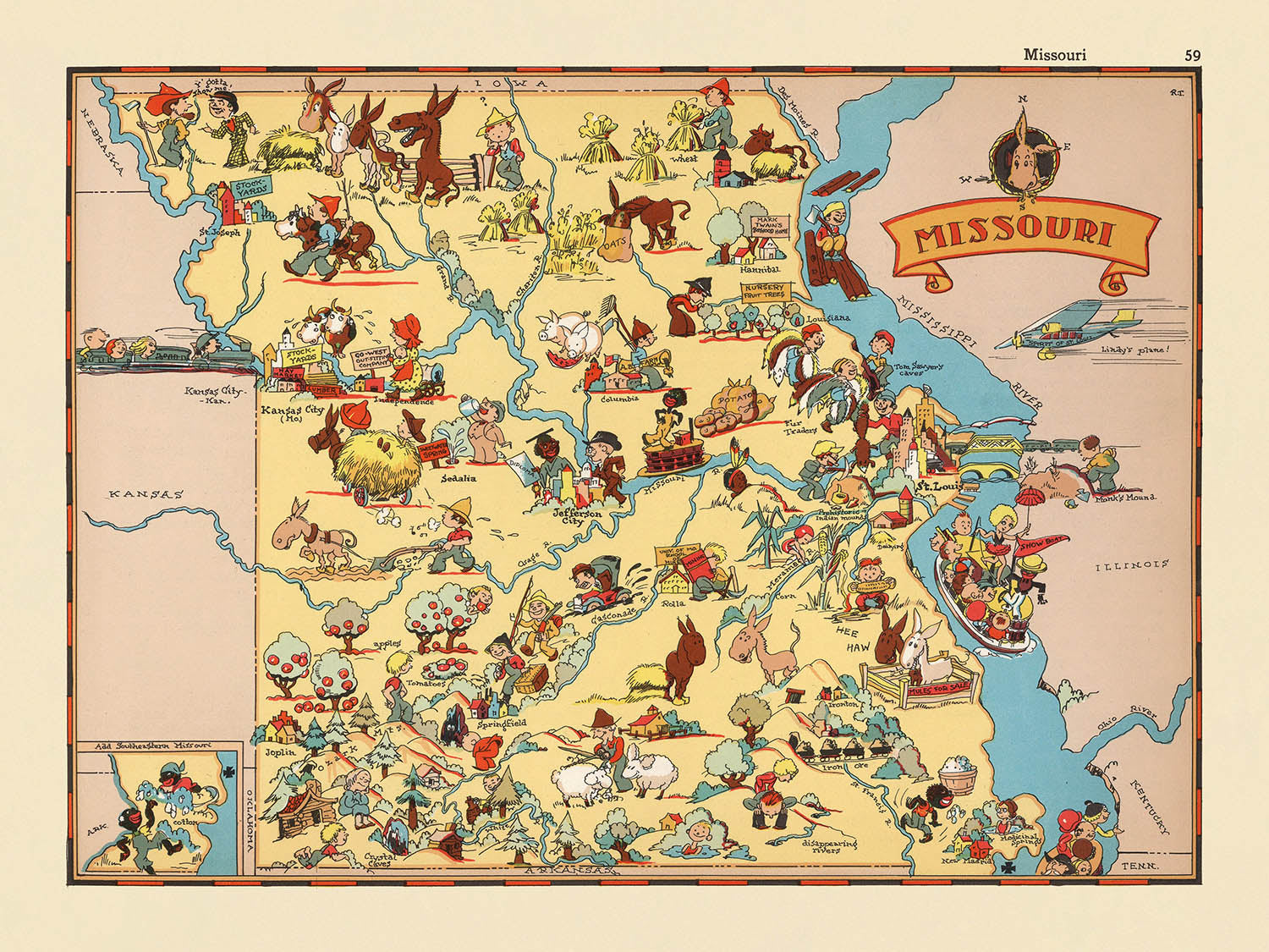


Mappa Pittorica del Missouri di Ruth Taylor White, 1935: St. Louis, Kansas City, Ozarks, fiumi Mississippi e Missouri, Jefferson City
- All taxes and duties included
- Handmade & dispatched in 1-2 days
-
90 day money back guarantee
ⓘ
90 giorni per restituire e ricevere un rimborso
I prodotti possono essere restituiti entro 90 giorni per un rimborso completo, o cambio con un altro prodotto.
Per articoli personalizzati e su misura, potremmo offrirti un credito in negozio o una carta regalo non scadente, poiché non possiamo rivendere ordini personalizzati.
Se hai domande, contattaci. Per ulteriori informazioni, consulta la nostra politica di restituzione e cambio.

My maps are rare, museum-grade, restored old maps sourced from libraries, auction houses and private collections across the globe.
Framing & free personalisation available
1. Select your size
2. Frame & personalise your map
There is limited framing & personalisation capacity available. Order by 10am tomorrow for Christmas delivery.


Gift message & custom finish

If you want to add a gift message, or a finish (jigsaw, aluminium board, etc.) that is not available here, please request it in the "order note" when you check out.
Every order is custom made, so if you need the size adjusted slightly, or printed on an unusual material, just let us know. We've done thousands of custom orders over the years, so there's (almost) nothing we can't manage.
You can also contact us before you order, if you prefer!

- Handmade locally. No import duty or tax
- FREE Delivery by Christmas
- Love it or your money back (90 days)
- Questions? WhatsApp me any time
Own a piece of history
5,000+ 5 star reviews


Entra nel vibrante mondo del Missouri degli anni '30 con la mappa pittorica affascinante, "Missouri", originariamente realizzata da Ruth Taylor White nel 1935. Quest'opera cartografica incantevole offre un vivace tableau dello Stato di Show-Me, mescolando arte fantasiosa con una ricca narrazione storica. Il titolo originale della mappa, semplicemente "Missouri", riflette il suo obiettivo di catturare l'essenza dello stato in un particolare momento nel tempo, invitando gli spettatori a esplorare un arazzo di cultura, industria e bellezza naturale. Ogni angolo della mappa esplode di colore e carattere, trasportandoti in un'epoca passata quando il paesaggio del Missouri veniva interpretato attraverso l'obiettivo giocoso e immaginativo di uno dei più celebri cartografi pittorici d'America.
Ruth Taylor White, la forza creativa dietro questa mappa, era rinomata per il suo approccio distintivo alla cartografia. Le sue mappe erano più di semplici strumenti di navigazione: erano finestre sull'anima di un luogo, vive di umorismo, colore locale e affettuose caricature. Lavorando insieme a suo marito, Frank J. Taylor, che spesso fungeva da editore e compilatore, White produsse una serie di mappe statali che divennero amate per la loro capacità di educare e intrattenere. La sua mappa del Missouri è una lezione magistrale in questa tradizione, piena di vignette deliziose che catturano il cuore agricolo dello stato, il vigore industriale e la vivacità culturale, tutte rese nel suo inconfondibile stile da cartone animato.
Il design di questa mappa è nulla di meno che una festa visiva. Ogni centimetro è adornato con illustrazioni affascinanti che trasmettono le caratteristiche distintive dello stato e il folklore locale. I possenti fiumi Mississippi e Missouri si snodano attraverso il paesaggio, la loro importanza sottolineata da vivaci battelli a vapore e scene fluviali animate. Le Montagne Ozark si ergono a sud, le cui pendici boschive sono punteggiate da attività legate al legname e attività all'aperto. L'abbondanza agricola è celebrata attraverso rappresentazioni di campi di mais, bestiame e vendemmie di uva, mentre la presenza di muli e pionieri allude al passato storicizzato del Missouri e alle tradizioni durature. Ogni illustrazione serve sia come decorazione che come documentazione, rendendo la mappa tanto informativa quanto deliziosa.
Oltre al suo fascino artistico, questa mappa offre uno sguardo affascinante sulle narrazioni sociali ed economiche che hanno plasmato il Missouri all'inizio del ventesimo secolo. Le diverse industrie dello stato—mining, agricoltura, vinificazione—sono tutte vividamente rappresentate, insieme a scene di musica, danza e vita quotidiana. Motivi nativi americani e figure storiche sono intrecciati nel tessuto della mappa, fornendo sottili cenni ai flussi più profondi del patrimonio del Missouri. Il cartiglio decorativo del titolo della mappa e i bordi stilizzati migliorano ulteriormente il suo fascino d'epoca, riflettendo l'ottimismo e lo spirito creativo degli anni '30.
Le città e i paesi rappresentati sulla mappa leggono come un elenco delle comunità più storiche del Missouri, dalle metropoli vivaci di Kansas City e St. Louis alla storica città fluviale di Hannibal e alla capitale statale, Jefferson City. Ogni insediamento è posizionato con cura, offrendo un senso della geografia dello stato e dell'interconnessione della sua gente. Questa mappa non è semplicemente un record di nomi di luoghi e confini: è una celebrazione dell'identità unica del Missouri, una testimonianza dell'arte di Ruth Taylor White e un pezzo di Americana che continua a incantare collezionisti e appassionati di storia.
Città e paesi su questa mappa
- Kansas City
- St. Louis
- Springfield
- Columbia
- St. Joseph
- Joplin
- Jefferson City
- Hannibal
- Sedalia
- Carthage
- Cape Girardeau
- Moberly
- Poplar Bluff
- Nevada
- Maryville
- Rolla
- Sikeston
- Fulton
- Messico
- Kirksville
Caratteristiche e Luoghi Notabili
- Il fiume Mississippi è illustrato in modo prominente lungo il confine orientale del Missouri.
- Il fiume Missouri è mostrato che si snoda attraverso lo stato.
- Scene agricole, come campi di mais e bestiame (bovini, maiali, polli), sono rappresentate in varie regioni.
- Una rappresentazione dell'attività mineraria, probabilmente riferita all'industria mineraria del piombo del Missouri.
- Illustrazioni di battelli a vapore sul fiume Mississippi.
- Immagini di persone impegnate in attività come la pesca e la caccia.
- Rappresentazione delle Montagne Ozark nella parte meridionale dello stato.
- Rappresentazioni artistiche di foreste e attività di disboscamento.
- Illustrazione di strumenti musicali e danza, che fanno riferimento al patrimonio culturale del Missouri.
- Scene di raccolta dell'uva e produzione di vino, probabilmente riferite all'industria vinicola dello stato.
- Immagini di figure e motivi dei nativi americani.
- Rappresentazioni di figure storiche o pionieri.
- Una grande pannocchia di mais, a simboleggiare l'importanza dell'agricoltura.
- Illustrazioni di muli, un simbolo spesso associato al Missouri.
- Il confine dello stato è chiaramente segnato e stilizzato.
- La mappa presenta un cartiglio decorativo con il nome "Missouri."
Contesto storico e di design
- Nome della mappa: Missouri (titolo originale come mostrato sulla mappa)
- Data di creazione: 1935
- Cartografo: Ruth Taylor White
- Editore: Frank J. Taylor (spesso accreditato come editore o compilatore per questa serie di atlanti)
- Tipo di mappa: Mappa tematica e pittorica di contea o stato
- Stile artistico: La mappa presenta illustrazioni vivaci, colorate e in stile cartone animato, caratteristiche delle mappe pittoriche degli anni '30.
- Temi rappresentati: La mappa utilizza illustrazioni giocose ed esagerate per rappresentare scene, industrie ed elementi culturali stereotipati associati al Missouri negli anni '30.
- Scopo: Progettata per intrattenere ed educare, offrendo uno sguardo fantasioso ma informativo sulla cultura, l'economia e la storia dello stato.
- Contesto storico: Riflette le narrazioni sociali e culturali del Missouri all'inizio del XX secolo, inclusa la vita agricola, industriale e sociale dello stato.
- Significato: Parte di una tendenza più ampia negli anni '30 di creare atlanti pittorici che mescolavano arte, umorismo e geografia, rendendo le mappe più accessibili e coinvolgenti per il pubblico.
- Contesto di design: Gli elementi decorativi sono utilizzati non solo per l'appeal visivo, ma per trasmettere informazioni sulle persone, le industrie e il modo di vivere del Missouri durante il periodo.
- Nota per: La sua fusione di arte e storia, fornendo un'idea di come il Missouri fosse percepito e rappresentato nella cultura popolare dell'epoca.
Si prega di controllare attentamente le immagini per assicurarsi che una specifica città o luogo sia mostrato su questa mappa. Puoi anche contattarci e chiedere di controllare la mappa per te.
Questa mappa appare fantastica in ogni dimensione, ma consiglio sempre di optare per una dimensione più grande se hai spazio. In questo modo puoi facilmente distinguere tutti i dettagli.
Questa mappa appare incredibile in dimensioni fino a 50 pollici (125 cm). Se stai cercando una mappa più grande, per favore contattaci.
Il modello nelle immagini dell'elenco tiene la versione di questa mappa da 18x24 pollici (45x60 cm).
La quinta immagine dell'elenco mostra un esempio del mio servizio di personalizzazione delle mappe.
Se stai cercando qualcosa di leggermente diverso, dai un'occhiata alla mia collezione dei migliori mappe antiche per vedere se qualcosa attira la tua attenzione.
Per favore contattami per verificare se una certa posizione, un monumento o una caratteristica è mostrata su questa mappa.
Questo sarebbe un meraviglioso regalo di compleanno, Natale, Festa del Papà, addio al lavoro, anniversario o inaugurazione della casa per qualcuno delle aree coperte da questa mappa.
Questa mappa è disponibile come stampa giclée su carta opaca archiviata senza acidi, oppure puoi acquistarla incorniciata. La cornice è una semplice cornice nera che si adatta alla maggior parte degli stili. Per favore, contattami se desideri un colore o un materiale di cornice diverso. Le mie cornici sono dotate di un vetro acrilico (perspex/acrylite) super chiaro di qualità museale, che è significativamente meno riflettente del vetro, più sicuro e arriverà sempre in perfette condizioni.
This map is also available as a float framed canvas, sometimes known as a shadow gap framed canvas or canvas floater. The map is printed on artist's cotton canvas and then stretched over a handmade box frame. We then "float" the canvas inside a wooden frame, which is available in a range of colours (black, dark brown, oak, antique gold and white). This is a wonderful way to present a map without glazing in front. See some examples of float framed canvas maps and explore the differences between my different finishes.
For something truly unique, this map is also available in "Unique 3D", our trademarked process that dramatically transforms the map so that it has a wonderful sense of depth. We combine the original map with detailed topography and elevation data, so that mountains and the terrain really "pop". For more info and examples of 3D maps, check my Unique 3D page.
For most orders, delivery time is about 3 working days. Personalised and customised products take longer, as I have to do the personalisation and send it to you for approval, which usually takes 1 or 2 days.
Please note that very large framed orders usually take longer to make and deliver.
If you need your order to arrive by a certain date, please contact me before you order so that we can find the best way of making sure you get your order in time.
I print and frame maps and artwork in 23 countries around the world. This means your order will be made locally, which cuts down on delivery time and ensures that it won't be damaged during delivery. You'll never pay customs or import duty, and we'll put less CO2 into the air.
All of my maps and art prints are well packaged and sent in a rugged tube if unframed, or surrounded by foam if framed.
I try to send out all orders within 1 or 2 days of receiving your order, though some products (like face masks, mugs and tote bags) can take longer to make.
If you select Express Delivery at checkout your order we will prioritise your order and send it out by 1-day courier (Fedex, DHL, UPS, Parcelforce).
Next Day delivery is also available in some countries (US, UK, Singapore, UAE) but please try to order early in the day so that we can get it sent out on time.
My standard frame is a gallery style black ash hardwood frame. It is simple and quite modern looking. My standard frame is around 20mm (0.8in) wide.
I use super-clear acrylic (perspex/acrylite) for the frame glass. It's lighter and safer than glass - and it looks better, as the reflectivity is lower.
Six standard frame colours are available for free (black, dark brown, dark grey, oak, white and antique gold). Custom framing and mounting/matting is available if you're looking for something else.
Most maps, art and illustrations are also available as a framed canvas. We use matte (not shiny) cotton canvas, stretch it over a sustainably sourced box wood frame, and then 'float' the piece within a wood frame. The end result is quite beautiful, and there's no glazing to get in the way.
All frames are provided "ready to hang", with either a string or brackets on the back. Very large frames will have heavy duty hanging plates and/or a mounting baton. If you have any questions, please get in touch.
See some examples of my framed maps and framed canvas maps.
Alternatively, I can also supply old maps and artwork on canvas, foam board, cotton rag and other materials.
If you want to frame your map or artwork yourself, please read my size guide first.
Alcune delle mie vecchie mappe sono ora disponibili come tele incorniciate. Per favore contattami se desideri ordinare una dimensione che non è disponibile nel mio negozio.
Le vecchie mappe su tela sono un'alternativa interessante alle mappe incorniciate in modo convenzionale. A seconda del tuo gusto personale e dell'arredamento della stanza, le mappe su tela possono "risaltare" un po' di più rispetto a una mappa incorniciata.
My maps are extremely high quality reproductions of original maps.
I source original, rare maps from libraries, auction houses and private collections around the world, restore them at my London workshop, and then use specialist giclée inks and printers to create beautiful maps that look even better than the original.
My maps are printed on acid-free archival matte (not glossy) paper that feels very high quality and almost like card. In technical terms the paper weight/thickness is 10mil/200gsm. It's perfect for framing.
I print with Epson ultrachrome giclée UV fade resistant pigment inks - some of the best inks you can find.
I can also make maps on canvas, cotton rag and other exotic materials.
Learn more about The Unique Maps Co.
Map personalisation
If you're looking for the perfect anniversary or housewarming gift, I can personalise your map to make it truly unique. For example, I can add a short message, or highlight an important location, or add your family's coat of arms.
The options are almost infinite. Please see my map personalisation page for some wonderful examples of what's possible.
To order a personalised map, select "personalise your map" before adding it to your basket.
Get in touch if you're looking for more complex customisations and personalisations.
Map ageing
I have been asked hundreds of times over the years by customers if they could buy a map that looks even older.
Well, now you can, by selecting Aged before you add a map to your basket.
All the product photos you see on this page show the map in its Original form. This is what the map looks like today.
If you select Aged, I will age your map by hand, using a special and unique process developed through years of studying old maps, talking to researchers to understand the chemistry of aging paper, and of course... lots of practice!
If you're unsure, stick to the Original colour of the map. If you want something a bit darker and older looking, go for Aged.
Se non sei soddisfatto del tuo ordine per qualsiasi motivo, contattami per un rimborso senza problemi. Si prega di consultare la nostra politica di reso e rimborso per ulteriori informazioni.
Sono molto sicuro che ti piacerà la tua mappa restaurata o la stampa d'arte. Lo faccio dal 1984. Sono un venditore Etsy a 5 stelle. Ho venduto decine di migliaia di mappe e stampe d'arte e ho oltre 5.000 recensioni reali a 5 stelle.
Utilizzo un processo unico per restaurare mappe e opere d'arte che richiede molto tempo e lavoro. Trovare le mappe e le illustrazioni originali può richiedere mesi. Utilizzo tecnologia all'avanguardia e incredibilmente costosa per scannerizzare e restaurarle. Di conseguenza, garantisco che le mie mappe e stampe d'arte siano superiori alle altre - ecco perché posso offrire un rimborso senza problemi.
Quasi tutte le mie mappe e stampe d'arte sembrano fantastiche a grandi dimensioni (200 cm, 6,5 piedi+) e posso anche incorniciarle e consegnarle a te, tramite un corriere speciale per oggetti di grandi dimensioni. Contattami per discutere delle tue esigenze specifiche.
Or try searching for something!


