


Mappa Pittorica del Vermont di Ruth Taylor White, 1935: Burlington, Montpelier, Rutland, Confini della Contea, Produzione di Sciroppo d'Acero
- All taxes and duties included
- Handmade & dispatched in 1-2 days
-
FREE gift preview
ⓘ
Digital gift preview
New for 2025: After you complete your order, you can send a beautiful digital preview to the gift recipient. Just provide their email address and we'll do the rest. (Their email address will not be stored or used for any other purpose.)
This is perfect for Christmas gifting, particularly if you're concerned that your order might not arrive in time for Christmas.
-
90 day money back guarantee
ⓘ
90 giorni per restituire e ricevere un rimborso
I prodotti possono essere restituiti entro 90 giorni per un rimborso completo, o cambio con un altro prodotto.
Per articoli personalizzati e su misura, potremmo offrirti un credito in negozio o una carta regalo non scadente, poiché non possiamo rivendere ordini personalizzati.
Se hai domande, contattaci. Per ulteriori informazioni, consulta la nostra politica di restituzione e cambio.

My maps are rare, museum-grade, restored old maps sourced from libraries, auction houses and private collections across the globe.
Framing & free personalisation available
1. Select your size
2. Frame & personalise your map
There is limited framing & personalisation capacity available. Order by 10am tomorrow for Christmas delivery.


Gift message & custom finish

If you want to add a gift message, or a finish (jigsaw, aluminium board, etc.) that is not available here, please request it in the "order note" when you check out.
Every order is custom made, so if you need the size adjusted slightly, or printed on an unusual material, just let us know. We've done thousands of custom orders over the years, so there's (almost) nothing we can't manage.
You can also contact us before you order, if you prefer!

- Handmade locally. No import duty or tax
- FREE Delivery by Christmas
- Love it or your money back (90 days)
- Questions? WhatsApp me any time
Own a piece of history
5,000+ 5 star reviews


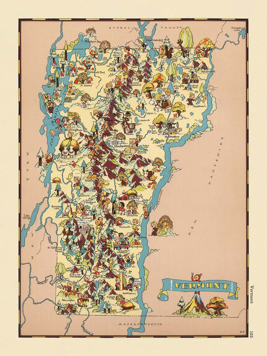
Entra nel vibrante mondo del Vermont degli anni '30 con la mappa pittorica originale intitolata "Vermont," realizzata dalla talentuosa Ruth Taylor White nel 1935. Questa mappa affascinante, disegnata nel periodo di massimo interesse dell'America per l'identità regionale, offre una finestra giocosa ma perspicace nello Stato delle Montagne Verdi come veniva percepito quasi un secolo fa. Ogni centimetro della mappa è vivo di colore e carattere, catturando l'essenza del Vermont attraverso illustrazioni vivaci che evocano le ricche tradizioni e la bellezza naturale dello stato. Dalle colline ondulate alle città vivaci, la mappa funge sia da delizia visiva che da documento storico, rendendola un pezzo prezioso per collezionisti e intenditori di Americana.
Ruth Taylor White, rinomata per la sua unica combinazione di arte e precisione cartografica, è stata una pioniera nella mappatura tematica e pittorica. Il suo lavoro si distingue per il suo approccio giocoso ma informativo, intrecciando elementi di cultura locale, economia e geografia. Le mappe di White erano spesso presenti in atlanti popolari dell'epoca, celebrate per la loro capacità di trasformare la geografia statica in coinvolgenti narrazioni visive. In "Vermont," il suo stile caratteristico brilla, con ogni contea animata da vivaci vignette che riflettono lo spirito e gli stereotipi del tempo. Le sue mappe non sono solo guide ai luoghi, ma finestre sull'immaginazione sociale dell'America degli anni '30.
Il design di questa mappa è semplicemente incantevole, mescolando dettagliate linee di confine delle contee con un ricco arazzo di illustrazioni. Invece di fare affidamento su simboli cartografici tradizionali, White popola il paesaggio con affascinanti figure dei cartoni animati impegnate in attività tipiche del Vermont: agricoltura lattiero-casearia, produzione di sciroppo d'acero, disboscamento e sci. Questi elementi pittorici servono sia come abbellimenti artistici che come indicatori culturali, evidenziando il patrimonio agricolo e l'attrattiva ricreativa dello stato. Il bordo decorativo della mappa e il titolo ornato ne aumentano ulteriormente il fascino, creando un senso di occasione e celebrazione attorno al soggetto del Vermont stesso.
Geograficamente, la mappa copre l'intero stato del Vermont, delineando meticolosamente le sue contee e mostrando le sue caratteristiche naturali: montagne, foreste e fiumi attraverso opere d'arte evocative. Città e paesi principali come Burlington, Rutland, Montpelier e Barre sono contrassegnati, ognuno reso con un occhio per il colore e il carattere locale. L'assenza di parchi nazionali o punti di riferimento esplicitamente etichettati è compensata dall'abbondanza di dettagli regionali, invitando gli spettatori a esplorare il paesaggio del Vermont attraverso la lente della cultura degli anni '30. L'interazione tra attività umana e paesaggio naturale sulla mappa offre un'istantanea dell'identità dello stato in un momento cruciale della sua storia.
Storicamente, questa mappa è significativa non solo per il suo merito artistico ma anche per il suo ruolo come artefatto culturale. Riflette gli atteggiamenti prevalenti, le aspirazioni e persino gli stereotipi della sua epoca, offrendo agli spettatori moderni l'opportunità di riflettere su come il Vermont fosse immaginato e rappresentato nei media popolari. Il fascino duraturo della mappa risiede nella sua capacità di raccontare una storia: di luogo, persone e tempo, rendendola un'aggiunta eccezionale a qualsiasi collezione. Sia ammirata per la sua bellezza visiva che per la sua risonanza storica, "Vermont" di Ruth Taylor White rimane una testimonianza del potere duraturo delle mappe di catturare l'immaginazione e lo spirito di una regione.
Città e paesi su questa mappa
- Burlington
- South Burlington
- Rutland
- Barre
- Montpelier
- St. Albans
- Winooski
- Newport
- Vergennes
Caratteristiche e monumenti notevoli
- I confini della contea all'interno del Vermont sono chiaramente delineati.
- La mappa è riccamente illustrata con rappresentazioni pittoriche delle industrie locali (come l'allevamento di bestiame, la produzione di sciroppo d'acero e la silvicoltura).
- Illustrazioni del paesaggio naturale del Vermont, comprese montagne, foreste e fiumi.
- Figure dei cartoni animati impegnate in attività come sci, agricoltura e produzione di sciroppo, che riflettono l'identità culturale del Vermont.
- Bordo decorativo e cartiglio del titolo in uno stile fantasioso e colorato.
- Il nome dello stato "Vermont" è esposto in modo prominente in un banner decorativo.
- La mappa non include una legenda o una barra di scala.
Contesto storico e di design
- Nome della mappa: Vermont.
- Titolo originale: Vermont.
- Cartografo: Ruth Taylor White.
- Data di creazione: 1935.
- La mappa è una mappa tematica e pittorica della contea o dello stato, caratterizzata da illustrazioni vivaci e colorate in uno stile simile ai cartoni animati.
- La mappa racchiude scene stereotipate del Vermont degli anni '30, evidenziando aspetti della cultura, della geografia e dell'economia dello stato attraverso opere d'arte giocose.
- La mappa utilizza elementi pittorici per rappresentare le industrie locali, le usanze e le caratteristiche notevoli, riflettendo le tendenze artistiche e le percezioni sociali degli anni '30.
- La mappa offre un'idea di come il Vermont fosse visto culturalmente e geograficamente durante gli anni '30, servendo sia come documento storico che come pezzo di narrazione visiva.
- Le illustrazioni riflettono gli stereotipi e gli atteggiamenti culturali dell'epoca, fornendo una finestra sulla società americana degli anni '30.
- La mappa funge da strumento per comprendere sia la geografia del Vermont che il linguaggio visivo della cartografia storica americana.
Si prega di controllare attentamente le immagini per assicurarsi che una specifica città o luogo sia mostrato su questa mappa. Puoi anche contattarci e chiedere di controllare la mappa per te.
Questa mappa appare fantastica in ogni dimensione, ma consiglio sempre di optare per una dimensione più grande se hai spazio. In questo modo puoi facilmente distinguere tutti i dettagli.
Questa mappa sembra incredibile in dimensioni fino a 50 pollici (125 cm). Se stai cercando una mappa più grande, ti preghiamo di contattarci.
Il modello nelle immagini dell'elenco sta tenendo la versione 18x24 pollici (45x60 cm) di questa mappa.
La quinta immagine dell'elenco mostra un esempio del mio servizio di personalizzazione della mappa.
Se stai cercando qualcosa di leggermente diverso, dai un'occhiata alla mia collezione dei migliori mappe antiche per vedere se qualcosa attira la tua attenzione.
Per favore contattami per verificare se una certa posizione, monumento o caratteristica è mostrato su questa mappa.
Questo sarebbe un meraviglioso regalo di compleanno, Natale, festa del papà, partenza dal lavoro, anniversario o inaugurazione della casa per qualcuno delle aree coperte da questa mappa.
Questa mappa è disponibile come stampa giclée su carta opaca archiviata senza acidi, oppure puoi acquistarla incorniciata. La cornice è una semplice cornice nera che si adatta alla maggior parte degli stili. Ti preghiamo di contattarci se desideri un colore o materiale di cornice diverso. Le mie cornici sono dotate di vetro acrilico super chiaro di grado museale (perspex/acrylite), che è significativamente meno riflettente del vetro, più sicuro e arriverà sempre in perfette condizioni.
This map is also available as a float framed canvas, sometimes known as a shadow gap framed canvas or canvas floater. The map is printed on artist's cotton canvas and then stretched over a handmade box frame. We then "float" the canvas inside a wooden frame, which is available in a range of colours (black, dark brown, oak, antique gold and white). This is a wonderful way to present a map without glazing in front. See some examples of float framed canvas maps and explore the differences between my different finishes.
For something truly unique, this map is also available in "Unique 3D", our trademarked process that dramatically transforms the map so that it has a wonderful sense of depth. We combine the original map with detailed topography and elevation data, so that mountains and the terrain really "pop". For more info and examples of 3D maps, check my Unique 3D page.
For most orders, delivery time is about 3 working days. Personalised and customised products take longer, as I have to do the personalisation and send it to you for approval, which usually takes 1 or 2 days.
Please note that very large framed orders usually take longer to make and deliver.
If you need your order to arrive by a certain date, please contact me before you order so that we can find the best way of making sure you get your order in time.
I print and frame maps and artwork in 23 countries around the world. This means your order will be made locally, which cuts down on delivery time and ensures that it won't be damaged during delivery. You'll never pay customs or import duty, and we'll put less CO2 into the air.
All of my maps and art prints are well packaged and sent in a rugged tube if unframed, or surrounded by foam if framed.
I try to send out all orders within 1 or 2 days of receiving your order, though some products (like face masks, mugs and tote bags) can take longer to make.
If you select Express Delivery at checkout your order we will prioritise your order and send it out by 1-day courier (Fedex, DHL, UPS, Parcelforce).
Next Day delivery is also available in some countries (US, UK, Singapore, UAE) but please try to order early in the day so that we can get it sent out on time.
My standard frame is a gallery style black ash hardwood frame. It is simple and quite modern looking. My standard frame is around 20mm (0.8in) wide.
I use super-clear acrylic (perspex/acrylite) for the frame glass. It's lighter and safer than glass - and it looks better, as the reflectivity is lower.
Six standard frame colours are available for free (black, dark brown, dark grey, oak, white and antique gold). Custom framing and mounting/matting is available if you're looking for something else.
Most maps, art and illustrations are also available as a framed canvas. We use matte (not shiny) cotton canvas, stretch it over a sustainably sourced box wood frame, and then 'float' the piece within a wood frame. The end result is quite beautiful, and there's no glazing to get in the way.
All frames are provided "ready to hang", with either a string or brackets on the back. Very large frames will have heavy duty hanging plates and/or a mounting baton. If you have any questions, please get in touch.
See some examples of my framed maps and framed canvas maps.
Alternatively, I can also supply old maps and artwork on canvas, foam board, cotton rag and other materials.
If you want to frame your map or artwork yourself, please read my size guide first.
Alcune delle mie vecchie mappe sono ora disponibili come tele incorniciate. Per favore contattami se desideri ordinare una dimensione che non è disponibile nel mio negozio.
Le vecchie mappe su tela sono un'alternativa interessante alle mappe incorniciate in modo convenzionale. A seconda del tuo gusto personale e dell'arredamento della stanza, le mappe su tela possono "risaltare" un po' di più rispetto a una mappa incorniciata.
My maps are extremely high quality reproductions of original maps.
I source original, rare maps from libraries, auction houses and private collections around the world, restore them at my London workshop, and then use specialist giclée inks and printers to create beautiful maps that look even better than the original.
My maps are printed on acid-free archival matte (not glossy) paper that feels very high quality and almost like card. In technical terms the paper weight/thickness is 10mil/200gsm. It's perfect for framing.
I print with Epson ultrachrome giclée UV fade resistant pigment inks - some of the best inks you can find.
I can also make maps on canvas, cotton rag and other exotic materials.
Learn more about The Unique Maps Co.
Map personalisation
If you're looking for the perfect anniversary or housewarming gift, I can personalise your map to make it truly unique. For example, I can add a short message, or highlight an important location, or add your family's coat of arms.
The options are almost infinite. Please see my map personalisation page for some wonderful examples of what's possible.
To order a personalised map, select "personalise your map" before adding it to your basket.
Get in touch if you're looking for more complex customisations and personalisations.
Map ageing
I have been asked hundreds of times over the years by customers if they could buy a map that looks even older.
Well, now you can, by selecting Aged before you add a map to your basket.
All the product photos you see on this page show the map in its Original form. This is what the map looks like today.
If you select Aged, I will age your map by hand, using a special and unique process developed through years of studying old maps, talking to researchers to understand the chemistry of aging paper, and of course... lots of practice!
If you're unsure, stick to the Original colour of the map. If you want something a bit darker and older looking, go for Aged.
Se non sei soddisfatto del tuo ordine per qualsiasi motivo, contattami per un rimborso senza problemi. Si prega di consultare la nostra politica di reso e rimborso per ulteriori informazioni.
Sono molto sicuro che ti piacerà la tua mappa restaurata o la stampa d'arte. Lo faccio dal 1984. Sono un venditore Etsy a 5 stelle. Ho venduto decine di migliaia di mappe e stampe d'arte e ho oltre 5.000 recensioni reali a 5 stelle.
Utilizzo un processo unico per restaurare mappe e opere d'arte che richiede molto tempo e lavoro. Trovare le mappe e le illustrazioni originali può richiedere mesi. Utilizzo tecnologia all'avanguardia e incredibilmente costosa per scannerizzare e restaurarle. Di conseguenza, garantisco che le mie mappe e stampe d'arte siano superiori alle altre - ecco perché posso offrire un rimborso senza problemi.
Quasi tutte le mie mappe e stampe d'arte sembrano fantastiche a grandi dimensioni (200 cm, 6,5 piedi+) e posso anche incorniciarle e consegnarle a te, tramite un corriere speciale per oggetti di grandi dimensioni. Contattami per discutere delle tue esigenze specifiche.
Or try searching for something!


