


Mappa ferroviaria antica del sistema ferroviario di Denver e Rio Grande, 1882: Denver, Pueblo, Leadville, Contea di San Miguel, Utah
Compra 2, Ricevi 1 Gratuito
Se aggiungi 2 articoli al tuo carrello, puoi aggiungere un terzo prodotto gratuitamente.
Questo vale per tutte le mappe e opere d'arte, comprese le opere personalizzate e su misura. Puoi ordinare 3 dello stesso articolo, o 3 articoli diversi.
Questo equivale a uno sconto del 33%, che sarà il maggiore sconto disponibile nel mio negozio quest'anno.
Ti prego di approfittare dell'offerta e di coprire le tue pareti con bellissime mappe e opere d'arte!
Contattami se hai domande.
- All taxes and duties included
- Handmade & dispatched in 1-2 days
-
Complimentary gifting & design advice
ⓘ
Complimentary gifting & design advice
Available almost 24/7 on WhatsApp and email — we usually reply within minutes. We can help you:
- Choose a perfectly personalised gift
- Send a digital gift preview to the recipient
- Pick the ideal size for your wall
- Select the right finish and frame
Quick, friendly advice so you can order with confidence.
For last minute gifts, consider buying a digital gift card. We have over 5,000 maps and art prints to choose from.
-
90-day returns & 5-year guarantee
ⓘ
90 giorni per restituire e ricevere un rimborso
I prodotti possono essere restituiti entro 90 giorni per un rimborso completo, o cambio con un altro prodotto.
Per articoli personalizzati e su misura, potremmo offrirti un credito in negozio o una carta regalo non scadente, poiché non possiamo rivendere ordini personalizzati.
Se hai domande, contattaci. Per ulteriori informazioni, consulta la nostra politica di restituzione e cambio.

This is a museum-grade archival print from the original 1882 map — restored in our workshop and made to order on 220gsm archival matte paper or 400gsm artist's cotton canvas with pigment inks.
Professional framing & free personalisation available
1. Choose a size
2. Frame & personalise your map
Make your map unique with framing, hand-drawn customisation, vintage ageing, pop art text, unique 3D styling and more.


Gift message & custom finish

If you want to add a gift message, or a finish (jigsaw, aluminium board, etc.) that is not available here, please request it in the "order note" when you check out.
Every order is custom made, so if you need the size adjusted slightly, or printed on an unusual material, just let us know. We've done thousands of custom orders over the years, so there's (almost) nothing we can't manage.
You can also contact us before you order, if you prefer!

- Handmade locally. No import duty or tax
- FREE worldwide delivery
- 90-day returns & 5-year product guarantee
- Questions? WhatsApp me any time
Own a piece of history
7,000+ 5 star reviews


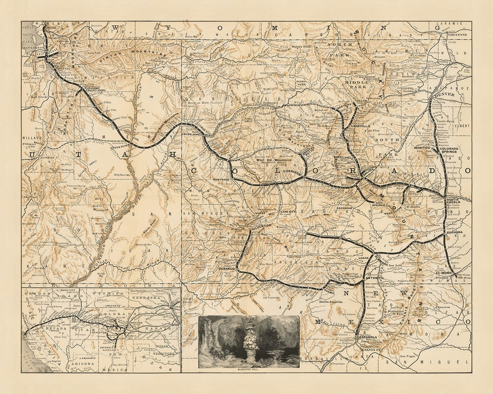
Entra nel passato leggendario del West americano con questa straordinaria mappa del 1882 del sistema ferroviario Denver e Rio Grande, un raro artefatto dell'inizio dell'era ferroviaria della regione. Creata dalla Denver & Rio Grande Railroad stessa, questa mappa è stata progettata come un pezzo promozionale, catturando un momento trasformativo in cui i binari di ferro cucivano insieme i paesaggi aspri del Colorado, dello Utah e del New Mexico. La sua pubblicazione seguì da vicino la creazione della contea di San Miguel, contrassegnandola come un'edizione precoce e molto ricercata. Per collezionisti e appassionati di storia, questa mappa offre una finestra sull'ambiziosa espansione delle ferrovie che avrebbero per sempre alterato il tessuto economico e sociale del West.
Ciò che rende questa mappa particolarmente significativa è la sua dettagliata rappresentazione della rete in espansione della Denver & Rio Grande Railroad in un momento cruciale della storia americana. Ogni linea, giunzione e diramazione racconta una storia di intraprendenza ed esplorazione, mentre la ferrovia collegava le fiorenti città minerarie, i centri agricoli e le remote comunità montane. Città come Denver, Pueblo, Colorado Springs e Leadville sono in evidenza, riflettendo il loro status di hub vitali per il commercio e la migrazione. La chiara delimitazione dei confini della contea nella mappa—compresa la recentemente istituita contea di San Miguel—sottolinea i cambiamenti dinamici nella governance regionale e nei modelli di insediamento durante quest'epoca.
Oltre alla sua funzione pratica, la mappa serve da testimone della visione e della determinazione dei fondatori della ferrovia. La Denver & Rio Grande Railroad è stata fondamentale nell'aprire vasti territori delle Montagne Rocciose e del deserto alto, rendendo possibile lo sviluppo rapido di industrie come l'estrazione mineraria, l'allevamento e l'agricoltura. Le rotte mostrate qui, comprese le linee che raggiungono lo Utah e il New Mexico, evidenziano l'ambizione della ferrovia di diventare la “Scenic Line of the World,” portando prosperità e connettività in aree precedentemente isolate. L'enfasi della mappa sulle regioni e le città minerarie riflette anche le corse all'oro e all'argento che hanno definito i primi anni del Colorado.
Esteticamente, la mappa è un classico esempio del design cartografico della fine del XIX secolo, bilanciando chiarezza con un tocco promozionale. La sua attenta rappresentazione delle catene montuose, dei fiumi e delle linee di contea fornisce sia un contesto geografico che un'attrattiva visiva. Il fiume Rio Grande, prominente sulla mappa, ancorano lo spettatore nel paesaggio, mentre le audaci linee ferroviarie attirano l'occhio lungo le rotte che hanno plasmato il destino della regione. Le revisioni periodiche che questa mappa subirebbe negli anni successivi rendono questa edizione precoce particolarmente preziosa, catturando un momento prima della piena fioritura dell'estensione della ferrovia.
Possedere questa mappa non significa solo acquisire un pezzo d'arte, ma tenere in mano un capitolo della storia americana. Essa rappresenta un tangibile promemoria delle forze che hanno plasmato il West: ambizione, innovazione e la ricerca incessante di connessione attraverso terreni vasti e impegnativi. Che sia esposta in uno studio, in una biblioteca o in una galleria, questa mappa invita alla riflessione sui viaggi intrapresi, le città fondate e l'eredità duratura della Denver & Rio Grande Railroad nella storia degli Stati Uniti.
Luoghi su questa mappa
- Denver
- Pueblo
- Colorado Springs
- Leadville
- Gunnison
- Durango
- Silverton
- Alamosa
- Trinidad
- Salida
- Ouray
- Montrose
- Contea di San Miguel
- Fiume Rio Grande
- Grand Junction
- Aspen
- Canon City
- Buena Vista
- Del Norte
- Salt Lake City (Utah)
Caratteristiche e monumenti notevoli
- Linee ferroviarie chiaramente etichettate del sistema ferroviario Denver & Rio Grande
- Rappresentazione prominente della linea principale e delle linee secondarie
- Giunzioni e stazioni ferroviarie importanti chiaramente contrassegnate
- Catene montuose e fiumi indicati, fornendo un contesto geografico
- Confini e nomi delle contee distintamente mostrati, inclusa la recentemente formata Contea di San Miguel
- Percorsi che si estendono negli stati vicini (Utah e Nuovo Messico)
- Indicazione di espansioni ferroviarie pianificate o proposte
- Enfasi sulla connettività della ferrovia con le regioni minerarie e le città, riflettendo l'importanza economica dell'industria mineraria dell'epoca
Contesto storico e di design
- Rara edizione antica della mappa del sistema ferroviario Denver & Rio Grande, creata nel 1882
- Pubblicata poco dopo l'istituzione della Contea di San Miguel, Colorado
- Sottoposta a revisioni periodiche nel corso di diversi decenni, riflettendo l'espansione ferroviaria e la geografia in cambiamento
- Realizzata dalla Denver & Rio Grande Railroad come pezzo promozionale per mostrare la sua rete in espansione
- Mette in evidenza il ruolo della ferrovia nell'insediamento e nello sviluppo economico del West americano
- Progettata in uno stile classico di mappa promozionale ferroviaria della fine del XIX secolo, enfatizzando chiarezza e leggibilità
- Cattura un periodo trasformativo nella crescita di città, paesi e industrie lungo le rotte ferroviarie
Si prega di controllare attentamente le immagini per assicurarsi che una specifica città o luogo sia mostrato su questa mappa. Puoi anche contattarci e chiedere di controllare la mappa per te.
Questa mappa appare fantastica in ogni dimensione, ma consiglio sempre di optare per una dimensione più grande se hai spazio. In questo modo puoi facilmente distinguere tutti i dettagli.
Questa mappa appare incredibile in dimensioni fino a 70in (180cm). Se stai cercando una mappa più grande, per favore contattaci.
Il modello nelle immagini dell'elenco sta tenendo la versione 16x20in (40x50cm) di questa mappa.
La quinta immagine dell'elenco mostra un esempio del mio servizio di personalizzazione della mappa.
Se stai cercando qualcosa di leggermente diverso, dai un'occhiata alla mia collezione delle migliori mappe antiche per vedere se qualcosa attira la tua attenzione.
Per favore contattami per controllare se una certa posizione, monumento o caratteristica è mostrata su questa mappa.
Questa sarebbe una meravigliosa idea regalo per un compleanno, Natale, Festa del Papà, un congedo dal lavoro, un anniversario o un regalo per la casa per qualcuno delle aree coperte da questa mappa.
Questa mappa è disponibile come stampa giclée su carta opaca archiviata senza acidi, oppure puoi acquistarla incorniciata. La cornice è una semplice cornice nera che si adatta alla maggior parte degli stili. Per favore contattaci se desideri un colore o materiale di cornice diverso. Le mie cornici sono dotate di un acrilico super chiaro di grado museale (perspex/acrylite), che è significativamente meno riflettente del vetro, più sicuro e arriverà sempre in condizioni perfette.
This map is also available as a float framed canvas, sometimes known as a shadow gap framed canvas or canvas floater. The map is printed on artist's cotton canvas and then stretched over a handmade box frame. We then "float" the canvas inside a wooden frame, which is available in a range of colours (black, dark brown, oak, antique gold and white). This is a wonderful way to present a map without glazing in front. See some examples of float framed canvas maps and explore the differences between my different finishes.
For something truly unique, this map is also available in "Unique 3D", our trademarked process that dramatically transforms the map so that it has a wonderful sense of depth. We combine the original map with detailed topography and elevation data, so that mountains and the terrain really "pop". For more info and examples of 3D maps, check my Unique 3D page.
For most orders, delivery time is about 3 working days. Personalised and customised products take longer, as I have to do the personalisation and send it to you for approval, which usually takes 1 or 2 days.
Please note that very large framed orders usually take longer to make and deliver.
If you need your order to arrive by a certain date, please contact me before you order so that we can find the best way of making sure you get your order in time.
I print and frame maps and artwork in 23 countries around the world. This means your order will be made locally, which cuts down on delivery time and ensures that it won't be damaged during delivery. You'll never pay customs or import duty, and we'll put less CO2 into the air.
All of my maps and art prints are well packaged and sent in a rugged tube if unframed, or surrounded by foam if framed.
I try to send out all orders within 1 or 2 days of receiving your order, though some products (like face masks, mugs and tote bags) can take longer to make.
If you select Express Delivery at checkout your order we will prioritise your order and send it out by 1-day courier (Fedex, DHL, UPS, Parcelforce).
Next Day delivery is also available in some countries (US, UK, Singapore, UAE) but please try to order early in the day so that we can get it sent out on time.
My standard frame is a gallery style black ash hardwood frame. It is simple and quite modern looking. My standard frame is around 20mm (0.8in) wide.
I use super-clear acrylic (perspex/acrylite) for the frame glass. It's lighter and safer than glass - and it looks better, as the reflectivity is lower.
Six standard frame colours are available for free (black, dark brown, dark grey, oak, white and antique gold). Custom framing and mounting/matting is available if you're looking for something else.
Most maps, art and illustrations are also available as a framed canvas. We use matte (not shiny) cotton canvas, stretch it over a sustainably sourced box wood frame, and then 'float' the piece within a wood frame. The end result is quite beautiful, and there's no glazing to get in the way.
All frames are provided "ready to hang", with either a string or brackets on the back. Very large frames will have heavy duty hanging plates and/or a mounting baton. If you have any questions, please get in touch.
See some examples of my framed maps and framed canvas maps.
Alternatively, I can also supply old maps and artwork on canvas, foam board, cotton rag and other materials.
If you want to frame your map or artwork yourself, please read my size guide first.
Alcune delle mie vecchie mappe sono ora disponibili come tele incorniciate. Per favore contattami se desideri ordinare una dimensione che non è disponibile nel mio negozio.
Le vecchie mappe su tela sono un'alternativa interessante alle mappe incorniciate in modo convenzionale. A seconda del tuo gusto personale e dell'arredamento della stanza, le mappe su tela possono "risaltare" un po' di più rispetto a una mappa incorniciata.
My maps are extremely high quality reproductions of original maps.
I source original, rare maps from libraries, auction houses and private collections around the world, restore them at my London workshop, and then use specialist giclée inks and printers to create beautiful maps that look even better than the original.
My maps are printed on acid-free archival matte (not glossy) paper that feels very high quality and almost like card. In technical terms the paper weight/thickness is 10mil/200gsm. It's perfect for framing.
I print with Epson ultrachrome giclée UV fade resistant pigment inks - some of the best inks you can find.
I can also make maps on canvas, cotton rag and other exotic materials.
Learn more about The Unique Maps Co.
Map personalisation
If you're looking for the perfect anniversary or housewarming gift, I can personalise your map to make it truly unique. For example, I can add a short message, or highlight an important location, or add your family's coat of arms.
The options are almost infinite. Please see my map personalisation page for some wonderful examples of what's possible.
To order a personalised map, select "personalise your map" before adding it to your basket.
Get in touch if you're looking for more complex customisations and personalisations.
Map ageing
I have been asked hundreds of times over the years by customers if they could buy a map that looks even older.
Well, now you can, by selecting Aged before you add a map to your basket.
All the product photos you see on this page show the map in its Original form. This is what the map looks like today.
If you select Aged, I will age your map by hand, using a special and unique process developed through years of studying old maps, talking to researchers to understand the chemistry of aging paper, and of course... lots of practice!
If you're unsure, stick to the Original colour of the map. If you want something a bit darker and older looking, go for Aged.
Se non sei soddisfatto del tuo ordine per qualsiasi motivo, contattami per un rimborso senza problemi. Si prega di consultare la nostra politica di reso e rimborso per ulteriori informazioni.
Sono molto sicuro che ti piacerà la tua mappa restaurata o la stampa d'arte. Lo faccio dal 1984. Sono un venditore Etsy a 5 stelle. Ho venduto decine di migliaia di mappe e stampe d'arte e ho oltre 5.000 recensioni reali a 5 stelle.
Utilizzo un processo unico per restaurare mappe e opere d'arte che richiede molto tempo e lavoro. Trovare le mappe e le illustrazioni originali può richiedere mesi. Utilizzo tecnologia all'avanguardia e incredibilmente costosa per scannerizzare e restaurarle. Di conseguenza, garantisco che le mie mappe e stampe d'arte siano superiori alle altre - ecco perché posso offrire un rimborso senza problemi.
Quasi tutte le mie mappe e stampe d'arte sembrano fantastiche a grandi dimensioni (200 cm, 6,5 piedi+) e posso anche incorniciarle e consegnarle a te, tramite un corriere speciale per oggetti di grandi dimensioni. Contattami per discutere delle tue esigenze specifiche.
Or try searching for something!


