

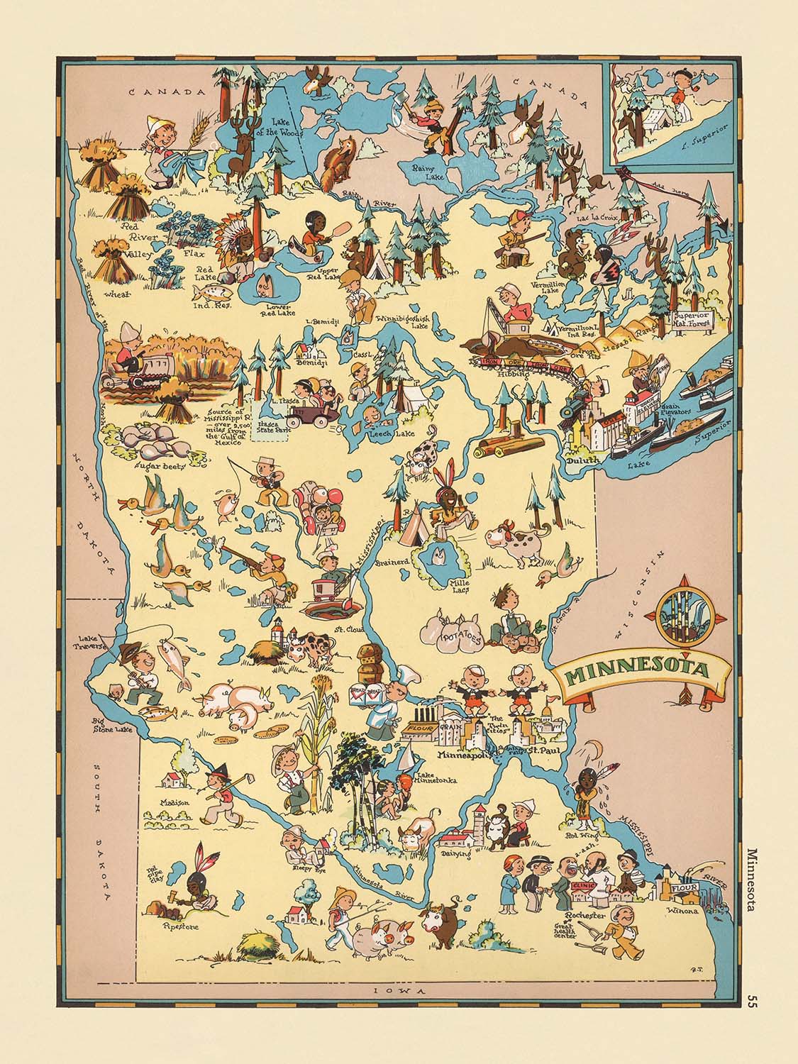


Mappa Pittorica del Minnesota di Ruth Taylor White, 1935: Minneapolis, Saint Paul, Duluth, Terra dei 10.000 Laghi, Industria del Legname
- All taxes and duties included
- Handmade & dispatched in 1-2 days
-
90 day money back guarantee
ⓘ
90 giorni per restituire e ricevere un rimborso
I prodotti possono essere restituiti entro 90 giorni per un rimborso completo, o cambio con un altro prodotto.
Per articoli personalizzati e su misura, potremmo offrirti un credito in negozio o una carta regalo non scadente, poiché non possiamo rivendere ordini personalizzati.
Se hai domande, contattaci. Per ulteriori informazioni, consulta la nostra politica di restituzione e cambio.

My maps are rare, museum-grade, restored old maps sourced from libraries, auction houses and private collections across the globe.
Framing & free personalisation available
1. Select your size
2. Frame & personalise your map
There is limited framing & personalisation capacity available. Order by 10am tomorrow for Christmas delivery.


Gift message & custom finish

If you want to add a gift message, or a finish (jigsaw, aluminium board, etc.) that is not available here, please request it in the "order note" when you check out.
Every order is custom made, so if you need the size adjusted slightly, or printed on an unusual material, just let us know. We've done thousands of custom orders over the years, so there's (almost) nothing we can't manage.
You can also contact us before you order, if you prefer!

- Handmade locally. No import duty or tax
- FREE Delivery by Christmas
- Love it or your money back (90 days)
- Questions? WhatsApp me any time
Own a piece of history
5,000+ 5 star reviews


Entra nel vibrante mondo dell'America degli anni '30 con "Minnesota", una mappa pittorica affascinante realizzata dalla rinomata Ruth Taylor White nel 1935. Questo incantevole pezzo cartografico è molto più di un semplice riferimento geografico: è una celebrazione dello spirito, della cultura e del paesaggio del Minnesota, vista attraverso gli occhi di uno dei cartografi più fantasiosi dell'epoca. Il titolo originale, "Minnesota", suggerisce l'intento dell'artista di racchiudere l'essenza dell'intero stato in un singolo tableau visivamente ricco. Dal momento in cui lo guardi, la mappa ti invita a viaggiare oltre i confini della contea e nel cuore dello Stato della Stella del Nord.
Lo stile distintivo di Ruth Taylor White è immediatamente evidente nelle illustrazioni esuberanti e nel design fantasioso della mappa. Ogni contea è meticolosamente delineata e etichettata, ma il vero fascino risiede nei deliziosi vignette sparse nel paesaggio. Figure cartoonesche—boscaioli, pescatori, contadini e appassionati di sport invernali—animano la mappa, offrendo un ritratto giocoso e affettuoso delle persone e delle tradizioni del Minnesota. L'approccio di White fonde magistralmente l'accuratezza geografica con la licenza artistica, creando un arazzo che è sia informativo che divertente, e che riflette l'ottimismo e l'umorismo del suo tempo.
Questa mappa è stata creata durante un periodo in cui gli atlanti pittorici godevano di una popolarità diffusa, offrendo agli americani un modo per esplorare il loro paese attraverso l'arte così come la cartografia. La rappresentazione del Minnesota da parte di White è particolarmente notevole per i suoi stereotipi affettuosi e i suoi colorati riferimenti al mosaico culturale dello stato. I coloni scandinavi, i nativi americani e la fauna selvatica sempre presente prendono vita in un modo che è sia evocativo che emblematico degli anni '30. Le caricature giocose e le scene vivaci della mappa catturano l'immaginazione, rendendola un artefatto coinvolgente per collezionisti e storici.
La bellezza naturale del Minnesota è in primo piano, con laghi, fiumi e foreste resi in dettagli vivaci. La reputazione dello stato come "Terra dei 10.000 Laghi" è celebrata attraverso illustrazioni di pesca, canoa e fauna selvatica abbondante, mentre le foreste del nord pullulano di immagini dell'industria del legname. Le vie navigabili della mappa sono animate da battelli a vapore e canoe, e il paesaggio invernale è punteggiato da scene di sci e pesca sul ghiaccio, evidenziando il legame duraturo dello stato con il tempo libero all'aperto. Ogni elemento pittorico serve come una finestra sulla geografia della regione e sui mezzi di sussistenza che ha sostenuto per generazioni.
Città e paesi sono collocati e etichettati con attenzione, con Minneapolis, Saint Paul, Duluth e Rochester tra i principali insediamenti rappresentati. Questi centri urbani, insieme a comunità più piccole come Bemidji, Hibbing e Red Wing, sono tessuti senza soluzione di continuità nella narrazione pittorica, sottolineando i loro ruoli nello sviluppo dello stato. Il bordo giocoso della mappa e il cartiglio del titolo disegnato a mano ne esaltano ulteriormente il fascino, mentre il suo significato storico risiede nella sua prospettiva unica: una capsula temporale visiva che cattura l'identità del Minnesota come era celebrata quasi un secolo fa. Questa mappa non è semplicemente un record di un luogo, ma un omaggio gioioso alle persone, ai paesaggi e all'eredità duratura dello stato.
Città e paesi su questa mappa
- Minneapolis
- Saint Paul
- Duluth
- Rochester
- St. Cloud
- Mankato
- Winona
- Bemidji
- Brainerd
- Hibbing
- Moorhead
- Fergus Falls
- Red Wing
- Austin
- Albert Lea
- Crookston
- Willmar
- Owatonna
- Faribault
- Virginia
Caratteristiche e Luoghi Notabili
- I confini e i nomi delle contee sono chiaramente delineati e etichettati in tutto lo stato.
- Numerose illustrazioni di persone impegnate in attività come pesca, agricoltura e disboscamento, che riflettono le industrie tradizionali del Minnesota.
- Riferimenti visivi a laghi e fiumi, sottolineando la reputazione del Minnesota come "Terra dei 10.000 Laghi."
- Illustrazioni di fauna selvatica, inclusi pesci e cervi, che evidenziano le risorse naturali dello stato.
- Rappresentazioni cartoonistiche di nativi americani, coloni scandinavi e boscaioli, che riflettono il patrimonio diversificato dello stato (nota: questi sono stereotipati e riflettono le attitudini dell'epoca).
- Disegni di attività agricole, come l'allevamento di bovini e la raccolta dei raccolti.
- Riferimenti visivi agli sport invernali e al tempo libero, inclusi sci e pesca sul ghiaccio.
- Illustrazioni di battelli a vapore e canoe sulle vie navigabili dello stato.
- Rappresentazioni pittoriche di foreste e industrie del legname nel Minnesota settentrionale.
- Border decorativo e cartiglio del titolo in uno stile giocoso e disegnato a mano.
Contesto storico e di design
- Nome della mappa: Minnesota.
- Data di creazione: 1935.
- Cartografo: Ruth Taylor White.
- La mappa fa parte di un atlante pictoriale o cartoonistico fantasioso e immaginativo degli Stati Uniti, popolare negli anni '30.
- La mappa è altamente colorata e cartoonistica, con illustrazioni giocose e rappresentazioni vivaci di persone, animali e attività.
- La mappa mette in evidenza scene stereotipate ed elementi culturali associati al Minnesota negli anni '30, utilizzando caricature e umorismo per rappresentare il carattere dello stato.
- La mappa fornisce un'idea di come il Minnesota fosse visto e rappresentato nella cultura popolare all'inizio del XX secolo e serve come un prezioso artefatto per comprendere le percezioni storiche e gli stereotipi.
- Ruth Taylor White era conosciuta per la creazione di mappe pictoriali vivaci che combinavano informazioni geografiche con illustrazioni divertenti e informative.
- La mappa è una celebrazione dell'identità del Minnesota, rendendola sia un'opera artistica che un documento storico.
Si prega di controllare attentamente le immagini per assicurarsi che una specifica città o luogo sia mostrato su questa mappa. Puoi anche contattarci e chiedere di controllare la mappa per te.
Questa mappa appare fantastica in ogni dimensione, ma consiglio sempre di optare per una dimensione più grande se hai spazio. In questo modo puoi facilmente distinguere tutti i dettagli.
Questa mappa appare incredibile in dimensioni fino a 50 pollici (125 cm). Se stai cercando una mappa più grande, ti preghiamo di contattarci.
Il modello nelle immagini dell'inserzione tiene la versione di questa mappa 18x24 pollici (45x60 cm).
La quinta immagine dell'inserzione mostra un esempio del mio servizio di personalizzazione della mappa.
Se stai cercando qualcosa di leggermente diverso, dai un'occhiata alla mia collezione dei migliori mappe antiche per vedere se qualcosa attira la tua attenzione.
Si prega di contattarmi per verificare se una certa posizione, un punto di riferimento o una caratteristica è mostrata su questa mappa.
Questo sarebbe un meraviglioso regalo per un compleanno, Natale, Festa del Papà, partenza dal lavoro, anniversario o inaugurazione della casa per qualcuno delle aree coperte da questa mappa.
Questa mappa è disponibile come stampa giclée su carta opaca archiviabile senza acidi, oppure puoi acquistarla incorniciata. La cornice è una semplice cornice nera che si adatta alla maggior parte degli stili. Ti preghiamo di contattarci se desideri un colore o un materiale diverso per la cornice. Le mie cornici sono dotate di un vetro acrilico super chiaro di qualità museale (perspex/acrylite), che è significativamente meno riflettente del vetro, più sicuro e arriverà sempre in perfette condizioni.
This map is also available as a float framed canvas, sometimes known as a shadow gap framed canvas or canvas floater. The map is printed on artist's cotton canvas and then stretched over a handmade box frame. We then "float" the canvas inside a wooden frame, which is available in a range of colours (black, dark brown, oak, antique gold and white). This is a wonderful way to present a map without glazing in front. See some examples of float framed canvas maps and explore the differences between my different finishes.
For something truly unique, this map is also available in "Unique 3D", our trademarked process that dramatically transforms the map so that it has a wonderful sense of depth. We combine the original map with detailed topography and elevation data, so that mountains and the terrain really "pop". For more info and examples of 3D maps, check my Unique 3D page.
For most orders, delivery time is about 3 working days. Personalised and customised products take longer, as I have to do the personalisation and send it to you for approval, which usually takes 1 or 2 days.
Please note that very large framed orders usually take longer to make and deliver.
If you need your order to arrive by a certain date, please contact me before you order so that we can find the best way of making sure you get your order in time.
I print and frame maps and artwork in 23 countries around the world. This means your order will be made locally, which cuts down on delivery time and ensures that it won't be damaged during delivery. You'll never pay customs or import duty, and we'll put less CO2 into the air.
All of my maps and art prints are well packaged and sent in a rugged tube if unframed, or surrounded by foam if framed.
I try to send out all orders within 1 or 2 days of receiving your order, though some products (like face masks, mugs and tote bags) can take longer to make.
If you select Express Delivery at checkout your order we will prioritise your order and send it out by 1-day courier (Fedex, DHL, UPS, Parcelforce).
Next Day delivery is also available in some countries (US, UK, Singapore, UAE) but please try to order early in the day so that we can get it sent out on time.
My standard frame is a gallery style black ash hardwood frame. It is simple and quite modern looking. My standard frame is around 20mm (0.8in) wide.
I use super-clear acrylic (perspex/acrylite) for the frame glass. It's lighter and safer than glass - and it looks better, as the reflectivity is lower.
Six standard frame colours are available for free (black, dark brown, dark grey, oak, white and antique gold). Custom framing and mounting/matting is available if you're looking for something else.
Most maps, art and illustrations are also available as a framed canvas. We use matte (not shiny) cotton canvas, stretch it over a sustainably sourced box wood frame, and then 'float' the piece within a wood frame. The end result is quite beautiful, and there's no glazing to get in the way.
All frames are provided "ready to hang", with either a string or brackets on the back. Very large frames will have heavy duty hanging plates and/or a mounting baton. If you have any questions, please get in touch.
See some examples of my framed maps and framed canvas maps.
Alternatively, I can also supply old maps and artwork on canvas, foam board, cotton rag and other materials.
If you want to frame your map or artwork yourself, please read my size guide first.
Alcune delle mie vecchie mappe sono ora disponibili come tele incorniciate. Per favore contattami se desideri ordinare una dimensione che non è disponibile nel mio negozio.
Le vecchie mappe su tela sono un'alternativa interessante alle mappe incorniciate in modo convenzionale. A seconda del tuo gusto personale e dell'arredamento della stanza, le mappe su tela possono "risaltare" un po' di più rispetto a una mappa incorniciata.
My maps are extremely high quality reproductions of original maps.
I source original, rare maps from libraries, auction houses and private collections around the world, restore them at my London workshop, and then use specialist giclée inks and printers to create beautiful maps that look even better than the original.
My maps are printed on acid-free archival matte (not glossy) paper that feels very high quality and almost like card. In technical terms the paper weight/thickness is 10mil/200gsm. It's perfect for framing.
I print with Epson ultrachrome giclée UV fade resistant pigment inks - some of the best inks you can find.
I can also make maps on canvas, cotton rag and other exotic materials.
Learn more about The Unique Maps Co.
Map personalisation
If you're looking for the perfect anniversary or housewarming gift, I can personalise your map to make it truly unique. For example, I can add a short message, or highlight an important location, or add your family's coat of arms.
The options are almost infinite. Please see my map personalisation page for some wonderful examples of what's possible.
To order a personalised map, select "personalise your map" before adding it to your basket.
Get in touch if you're looking for more complex customisations and personalisations.
Map ageing
I have been asked hundreds of times over the years by customers if they could buy a map that looks even older.
Well, now you can, by selecting Aged before you add a map to your basket.
All the product photos you see on this page show the map in its Original form. This is what the map looks like today.
If you select Aged, I will age your map by hand, using a special and unique process developed through years of studying old maps, talking to researchers to understand the chemistry of aging paper, and of course... lots of practice!
If you're unsure, stick to the Original colour of the map. If you want something a bit darker and older looking, go for Aged.
Se non sei soddisfatto del tuo ordine per qualsiasi motivo, contattami per un rimborso senza problemi. Si prega di consultare la nostra politica di reso e rimborso per ulteriori informazioni.
Sono molto sicuro che ti piacerà la tua mappa restaurata o la stampa d'arte. Lo faccio dal 1984. Sono un venditore Etsy a 5 stelle. Ho venduto decine di migliaia di mappe e stampe d'arte e ho oltre 5.000 recensioni reali a 5 stelle.
Utilizzo un processo unico per restaurare mappe e opere d'arte che richiede molto tempo e lavoro. Trovare le mappe e le illustrazioni originali può richiedere mesi. Utilizzo tecnologia all'avanguardia e incredibilmente costosa per scannerizzare e restaurarle. Di conseguenza, garantisco che le mie mappe e stampe d'arte siano superiori alle altre - ecco perché posso offrire un rimborso senza problemi.
Quasi tutte le mie mappe e stampe d'arte sembrano fantastiche a grandi dimensioni (200 cm, 6,5 piedi+) e posso anche incorniciarle e consegnarle a te, tramite un corriere speciale per oggetti di grandi dimensioni. Contattami per discutere delle tue esigenze specifiche.
Or try searching for something!


