

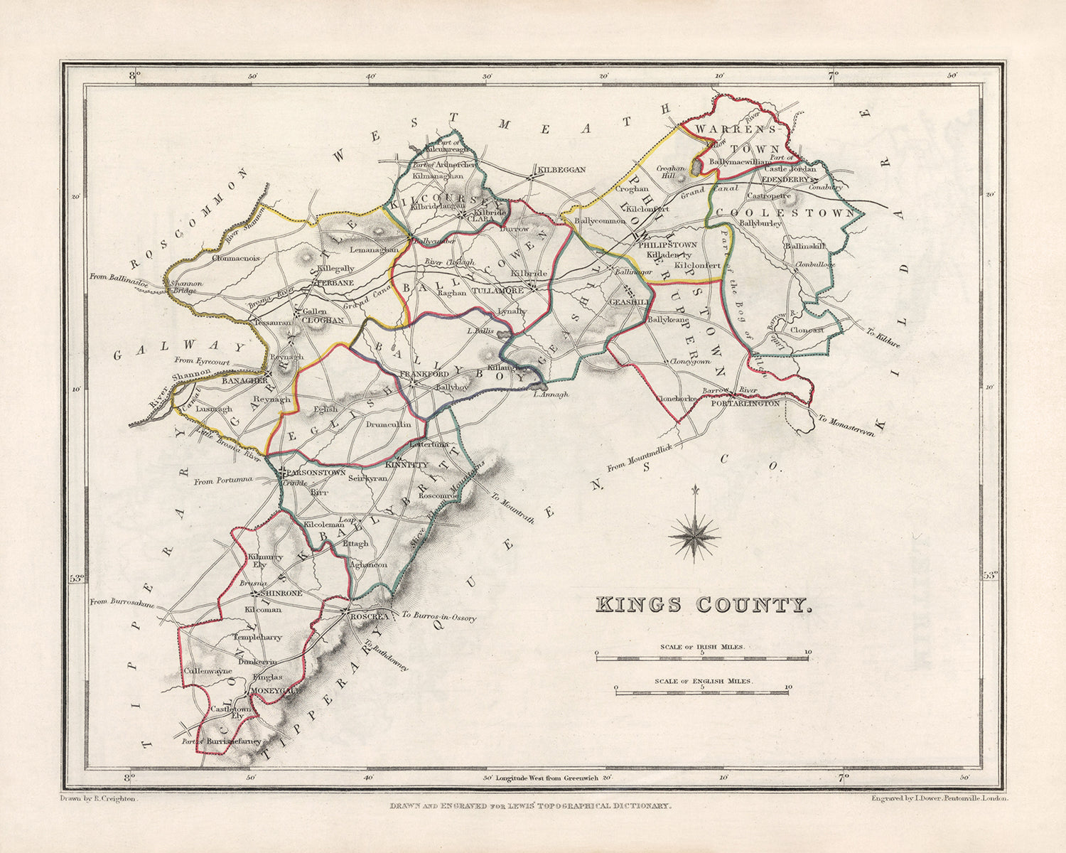
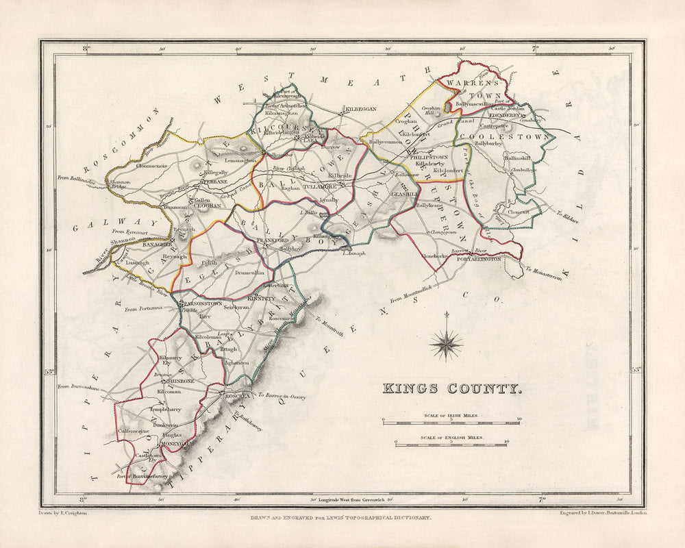


Mappa antica della contea di Offaly (King's) di Samuel Lewis, 1844: Tullamore, Birr, Banagher, Clara, Edenderry
20% di sconto su 2 — 33% di sconto su 3
Aggiungi qualsiasi due articoli idonei al tuo carrello per ricevere 20% di sconto. Aggiungi un terzo e sarà gratuito (equivalente a 33% di sconto quando acquisti tre).
Nessun codice necessario — l'offerta si applica automaticamente al checkout.
Valido su tutte le mappe standard e le stampe d'arte fine. Puoi mescolare e abbinare qualsiasi design.
Se desideri spedire articoli a più indirizzi, ti preghiamo di contattarci prima di effettuare il tuo ordine.
Le commissioni personalizzate e su misura sono escluse.
Contattaci se hai domande
- All taxes and duties included
- Handmade & dispatched in 1-2 days
-
Complimentary gifting & design advice
ⓘ
Complimentary gifting & design advice
Available almost 24/7 on WhatsApp and email — we usually reply within minutes. We can help you:
- Choose a perfectly personalised gift
- Send a digital gift preview to the recipient
- Pick the ideal size for your wall
- Select the right finish and frame
Quick, friendly advice so you can order with confidence.
For last minute gifts, consider buying a digital gift card. We have over 5,000 maps and art prints to choose from.
-
90-day returns & 5-year guarantee
ⓘ
90 giorni per restituire e ricevere un rimborso
I prodotti possono essere restituiti entro 90 giorni per un rimborso completo, o cambio con un altro prodotto.
Per articoli personalizzati e su misura, potremmo offrirti un credito in negozio o una carta regalo non scadente, poiché non possiamo rivendere ordini personalizzati.
Se hai domande, contattaci. Per ulteriori informazioni, consulta la nostra politica di restituzione e cambio.

This is a museum-grade archival print from the original 1844 map — restored in our workshop and made to order on 220gsm archival matte paper or 400gsm artist's cotton canvas with pigment inks.
Professional framing & free personalisation available.
1. Choose a size
2. Frame & personalise your map
Make your map unique with framing, hand-drawn customisation, vintage ageing, pop art text, unique 3D styling and more.


Gift message & custom finish

If you want to add a gift message, or a finish (jigsaw, aluminium board, etc.) that is not available here, please request it in the "order note" when you check out.
Every order is custom made, so if you need the size adjusted slightly, or printed on an unusual material, just let us know. We've done thousands of custom orders over the years, so there's (almost) nothing we can't manage.
You can also contact us before you order, if you prefer!

- Handmade locally. No import duty or tax
- FREE worldwide delivery
- 90-day returns & 5-year product guarantee
- Questions? WhatsApp me any time
Own a piece of history
7,000+ 5 star reviews


Questa Vecchia Mappa di Offaly (King's) di Samuel Lewis nel 1844 è un pezzo affascinante che offre uno sguardo nel paesaggio storico della Contea di Offaly, Irlanda. Con i suoi dettagli intricati e la sua squisita lavorazione, questa mappa è un vero oggetto da collezione per gli appassionati di storia e di cartografia.
Presentando le principali città, paesi e altre caratteristiche interessanti della Contea di Offaly (King's), questa mappa mette in mostra il ricco patrimonio e i luoghi notevoli della regione. Anche se alcune città moderne potrebbero non essere rappresentate su questa mappa, offre un'opportunità entusiasmante per esplorare nomi precedenti e scoprire come il paesaggio sia evoluto nel tempo.
Le colonie e i centri abitati notevoli fondati prima del 1840 all'interno dei confini storici della Contea di Offaly (King's) includono:
- Tullamore (c. 1571): Conosciuta per la sua grandiosa Distilleria Tullamore Dew e il storico Castello di Charleville, Tullamore è una città ricca di storia e fascino.
- Birr (c. 1620): Casa del magnifico Castello di Birr e del suo famoso Grande Telescopio, Birr è una città rinomata per i suoi successi scientifici e architettonici.
- Banagher (c. 1609): Situata sulle rive del Fiume Shannon, Banagher vanta una ricca storia marittima e offre viste mozzafiato sul fiume.
- Clara (c. 1620): Clara è una vivace città che un tempo era un centro industriale, particolarmente conosciuta per i suoi fiorenti mulini tessili.
- Edenderry (c. 1770): Immersa nel cuore di Offaly, Edenderry è una città con un forte patrimonio agricolo e un ricco arazzo di siti storici.
La lista delle colonie e dei centri abitati notevoli fondati prima del 1840 continua con:
- Shinrone (c. 1600): Un pittoresco villaggio noto per le sue affascinanti case con tetto di paglia e la storica Chiesa di Santa Maria.
- Rhode (c. 1609): Famoso per il suo antico sito monastico e l'imponente Castello di Rhode, questo villaggio è una testimonianza del passato medievale dell'Irlanda.
- Ferbane (c. 1620): Un tempo una vivace città di mercato, Ferbane ospita il notevole Sito Monastico di Clonmacnoise, un importante sito archeologico e religioso.
- Ballycumber (c. 1620): Circondata da una campagna ondulata, Ballycumber è un tranquillo villaggio con un ricco patrimonio agricolo.
- Shannonbridge (c. 1620): Situata sulle rive del Fiume Shannon, Shannonbridge offre uno sguardo nella storia delle vie d'acqua dell'Irlanda e presenta il famoso Ponte di Clonmacnoise.
- Kilcormac (c. 1620): Kilcormac è un affascinante villaggio con un forte senso di comunità e una ricca storia che risale a secoli fa.
- Daingean (c. 1620): Un tempo conosciuto come Philipstown, Daingean è un pittoresco villaggio con una storia affascinante e una posizione panoramica lungo il Canale Grande.
- Kinnitty (c. 1620): Immersa ai piedi delle montagne Slieve Bloom, Kinnitty è rinomata per i suoi paesaggi mozzafiato e l'incantevole Castello di Kinnitty.
- Cloghan (c. 1620): Circondata da una bellissima campagna, Cloghan è un piccolo villaggio con una comunità unita e un ricco patrimonio agricolo.
- Shannon Harbour (c. 1620): Situato lungo il Canale Grande, Shannon Harbour è un pittoresco villaggio noto per le sue tranquille vie d'acqua e la sua bellezza paesaggistica.
- Durrow (c. 1620): Durrow è un affascinante villaggio con una ricca storia ed è sede dell'imponente Abbazia di Durrow e della Croce Alta.
- Clonbullogue (c. 1620): Clonbullogue è un caratteristico villaggio con una forte storia dell'aviazione, noto per la sua attività di volo in aliante e il vicino Club Paracadutisti Irlandesi.
- Clonony (c. 1620): Questo villaggio ospita il notevole Castello di Clonony, una villa Tudor splendidamente conservata che offre uno sguardo sul patrimonio architettonico dell'Irlanda.
- Rahan (c. 1620): Rahan è rinomata per il suo antico sito monastico, che presenta l'imponente Chiesa Cristiana Primordiale di Rahan e la Torre Rotonda.
- Kilbeggan (c. 1620): Kilbeggan è una città storica conosciuta per la sua famosa Distilleria di Kilbeggan, una delle distillerie autorizzate più antiche del mondo.
- Belmont (c. 1620): Circondato da una lussureggiante vegetazione, Belmont è un villaggio tranquillo con una ricca storia agricola e un forte senso di comunità.
- Mountbolus (c. 1620): Mountbolus è un pittoresco villaggio con una comunità affiatata e una posizione panoramica nel cuore di Offaly.
- Clonmacnoise (c. 545): Un famoso sito monastico e un importante centro di religione e apprendimento nell'Irlanda medievale, Clonmacnoise è un'attrazione storica da non perdere.
- Ballyboy (c. 1620): Ballyboy è un affascinante villaggio con una ricca eredità agricola e un'atmosfera tranquilla.
- Tubber (c. 1620): Annidato nelle Montagne Slieve Bloom, Tubber è un villaggio pittoresco noto per i suoi splendidi dintorni naturali e la bellezza panoramica.
- Ballinagar (c. 1620): Ballinagar è un villaggio pittoresco con un forte senso di comunità e una ricca storia agricola.
- Geashill (c. 1620): Casa del suggestivo Castello di Geashill, questo villaggio offre uno sguardo sul patrimonio architettonico e sul passato storico dell'Irlanda.
- Pollagh (c. 1620): Circondata da una bellissima campagna, Pollagh è un piccolo villaggio con una ricca storia agricola e una comunità affiatata.
- Broughal (c. 1620): Broughal è un affascinante villaggio con un'atmosfera tranquilla e un forte senso di comunità.
- Killeigh (c. 1620): Killeigh è un villaggio pittoresco noto per la sua bellezza panoramica e i suoi siti storici, tra cui l'imponente Castello di Killeigh.
- Bracknagh (c. 1620): Bracknagh è un villaggio pittoresco con una ricca eredità agricola e una comunità affiatata.
- Cadamstown (c. 1620): Annidato nelle Montagne Slieve Bloom, Cadamstown è un villaggio pittoresco rinomato per i suoi splendidi dintorni naturali e le attività all'aperto.
I confini, i fiumi, i canyon, i parchi nazionali e i fenomeni naturali notevoli nella Contea di Offaly (King's), Irlanda includono il Fiume Shannon, le Montagne Slieve Bloom e il Canale Grande.
Tra il 1800 e il 1850, la Contea di Offaly (King's) ha assistito a diversi eventi storici significativi, tra cui la Ribellione Irlandese del 1803 guidata da Robert Emmet e la Grande Carestia che colpì l'Irlanda dal 1845 al 1852, causando devastazioni diffuse e massicce emigrazioni.
Possiedi un pezzo di storia con questa Antica Mappa di Offaly (King's) di Samuel Lewis del 1844. Immergiti nel ricco patrimonio e nella bellezza affascinante della Contea di Offaly (King's), Irlanda, mentre esplori le città, i paesi e i luoghi storici che hanno plasmato questa straordinaria regione.
Si prega di controllare attentamente le immagini per assicurarsi che un particolare paese o luogo sia mostrato su questa mappa. Puoi anche contattarci e chiedere di controllare la mappa per te.
Questa mappa appare fantastica in tutte le dimensioni: 12x16in (30.5x41cm), 16x20in (40.5x51cm), 18x24in (45.5x61cm), 24x30in (61x76cm), 32x40in (81.5x102cm) e 40x50in (102x127cm), ma appare ancora meglio quando stampata in grande.
Posso creare bellissime stampe di grandi dimensioni di questa mappa fino a 50in (127cm). Si prega di contattare se si cercano opzioni di incorniciatura più grandi, personalizzate o diverse.
Il modello nelle immagini dell'annuncio tiene in mano la versione di questa mappa 16x20in (40.5x51cm).
La quinta immagine dell'annuncio mostra un esempio del mio servizio di personalizzazione della mappa.
Si prega di notare che la mappa non incorniciata 24x30in (61x76cm) ha bordi bianchi attorno alla mappa. Questi bordi possono aiutarti con l'incorniciatura, oppure se non ne hai bisogno, sono molto facili da tagliare con le forbici. Tutte le altre mappe, comprese quelle incorniciate, sembrano esattamente come le immagini dell'annuncio.
Se stai cercando qualcosa di leggermente diverso, dai un'occhiata alla mia collezione di mappe del Regno Unito e dell'Irlanda.
Per favore contattami per verificare se una certa posizione, un monumento o una caratteristica è mostrata su questa mappa.
Questa sarebbe un'ottima idea regalo per un compleanno, Natale, Festa del Papà, addio al lavoro, anniversario o inaugurazione di una casa per qualcuno delle aree coperte da questa mappa.
Questa mappa è disponibile come stampa giclée su carta opaca archiviata senza acidi, oppure puoi acquistarla incorniciata. La cornice è una semplice cornice nera che si adatta alla maggior parte degli stili. Per favore, contattami se desideri un colore o un materiale della cornice diverso. Le mie cornici sono dotate di vetro acrilico super chiaro di grado museale (perspex/acrylite), che è significativamente meno riflettente del vetro, più sicuro e arriverà sempre in perfette condizioni.
This map is also available as a float framed canvas, sometimes known as a shadow gap framed canvas or canvas floater. The map is printed on artist's cotton canvas and then stretched over a handmade box frame. We then "float" the canvas inside a wooden frame, which is available in a range of colours (black, dark brown, oak, antique gold and white). This is a wonderful way to present a map without glazing in front. See some examples of float framed canvas maps and explore the differences between my different finishes.
For something truly unique, this map is also available in "Unique 3D", our trademarked process that dramatically transforms the map so that it has a wonderful sense of depth. We combine the original map with detailed topography and elevation data, so that mountains and the terrain really "pop". For more info and examples of 3D maps, check my Unique 3D page.
For most orders, delivery time is about 3 working days. Personalised and customised products take longer, as I have to do the personalisation and send it to you for approval, which usually takes 1 or 2 days.
Please note that very large framed orders usually take longer to make and deliver.
If you need your order to arrive by a certain date, please contact me before you order so that we can find the best way of making sure you get your order in time.
I print and frame maps and artwork in 23 countries around the world. This means your order will be made locally, which cuts down on delivery time and ensures that it won't be damaged during delivery. You'll never pay customs or import duty, and we'll put less CO2 into the air.
All of my maps and art prints are well packaged and sent in a rugged tube if unframed, or surrounded by foam if framed.
I try to send out all orders within 1 or 2 days of receiving your order, though some products (like face masks, mugs and tote bags) can take longer to make.
If you select Express Delivery at checkout your order we will prioritise your order and send it out by 1-day courier (Fedex, DHL, UPS, Parcelforce).
Next Day delivery is also available in some countries (US, UK, Singapore, UAE) but please try to order early in the day so that we can get it sent out on time.
My standard frame is a gallery style black ash hardwood frame. It is simple and quite modern looking. My standard frame is around 20mm (0.8in) wide.
I use super-clear acrylic (perspex/acrylite) for the frame glass. It's lighter and safer than glass - and it looks better, as the reflectivity is lower.
Six standard frame colours are available for free (black, dark brown, dark grey, oak, white and antique gold). Custom framing and mounting/matting is available if you're looking for something else.
Most maps, art and illustrations are also available as a framed canvas. We use matte (not shiny) cotton canvas, stretch it over a sustainably sourced box wood frame, and then 'float' the piece within a wood frame. The end result is quite beautiful, and there's no glazing to get in the way.
All frames are provided "ready to hang", with either a string or brackets on the back. Very large frames will have heavy duty hanging plates and/or a mounting baton. If you have any questions, please get in touch.
See some examples of my framed maps and framed canvas maps.
Alternatively, I can also supply old maps and artwork on canvas, foam board, cotton rag and other materials.
If you want to frame your map or artwork yourself, please read my size guide first.
Alcune delle mie vecchie mappe sono ora disponibili come tele incorniciate. Per favore contattami se desideri ordinare una dimensione che non è disponibile nel mio negozio.
Le vecchie mappe su tela sono un'alternativa interessante alle mappe incorniciate in modo convenzionale. A seconda del tuo gusto personale e dell'arredamento della stanza, le mappe su tela possono "risaltare" un po' di più rispetto a una mappa incorniciata.
My maps are extremely high quality reproductions of original maps.
I source original, rare maps from libraries, auction houses and private collections around the world, restore them at my London workshop, and then use specialist giclée inks and printers to create beautiful maps that look even better than the original.
My maps are printed on acid-free archival matte (not glossy) paper that feels very high quality and almost like card. In technical terms the paper weight/thickness is 10mil/200gsm. It's perfect for framing.
I print with Epson ultrachrome giclée UV fade resistant pigment inks - some of the best inks you can find.
I can also make maps on canvas, cotton rag and other exotic materials.
Learn more about The Unique Maps Co.
Map personalisation
If you're looking for the perfect anniversary or housewarming gift, I can personalise your map to make it truly unique. For example, I can add a short message, or highlight an important location, or add your family's coat of arms.
The options are almost infinite. Please see my map personalisation page for some wonderful examples of what's possible.
To order a personalised map, select "personalise your map" before adding it to your basket.
Get in touch if you're looking for more complex customisations and personalisations.
Map ageing
I have been asked hundreds of times over the years by customers if they could buy a map that looks even older.
Well, now you can, by selecting Aged before you add a map to your basket.
All the product photos you see on this page show the map in its Original form. This is what the map looks like today.
If you select Aged, I will age your map by hand, using a special and unique process developed through years of studying old maps, talking to researchers to understand the chemistry of aging paper, and of course... lots of practice!
If you're unsure, stick to the Original colour of the map. If you want something a bit darker and older looking, go for Aged.
Se non sei soddisfatto del tuo ordine per qualsiasi motivo, contattami per un rimborso senza problemi. Si prega di consultare la nostra politica di reso e rimborso per ulteriori informazioni.
Sono molto sicuro che ti piacerà la tua mappa restaurata o la stampa d'arte. Lo faccio dal 1984. Sono un venditore Etsy a 5 stelle. Ho venduto decine di migliaia di mappe e stampe d'arte e ho oltre 5.000 recensioni reali a 5 stelle.
Utilizzo un processo unico per restaurare mappe e opere d'arte che richiede molto tempo e lavoro. Trovare le mappe e le illustrazioni originali può richiedere mesi. Utilizzo tecnologia all'avanguardia e incredibilmente costosa per scannerizzare e restaurarle. Di conseguenza, garantisco che le mie mappe e stampe d'arte siano superiori alle altre - ecco perché posso offrire un rimborso senza problemi.
Quasi tutte le mie mappe e stampe d'arte sembrano fantastiche a grandi dimensioni (200 cm, 6,5 piedi+) e posso anche incorniciarle e consegnarle a te, tramite un corriere speciale per oggetti di grandi dimensioni. Contattami per discutere delle tue esigenze specifiche.
Or try searching for something!


