

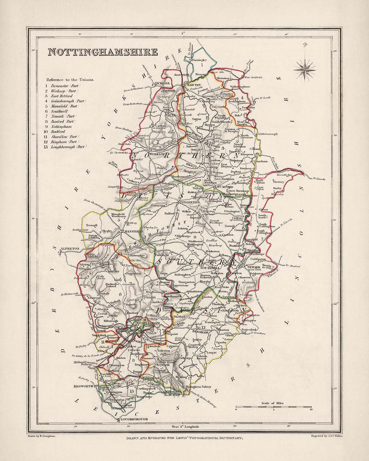


Mappa antica del Nottinghamshire di Samuel Lewis, 1844: Nottingham, Mansfield, Worksop, Newark, Retford
- All taxes and duties included
- Handmade & dispatched in 1-2 days
-
90 day money back guarantee
ⓘ
90 giorni per restituire e ricevere un rimborso
I prodotti possono essere restituiti entro 90 giorni per un rimborso completo, o cambio con un altro prodotto.
Per articoli personalizzati e su misura, potremmo offrirti un credito in negozio o una carta regalo non scadente, poiché non possiamo rivendere ordini personalizzati.
Se hai domande, contattaci. Per ulteriori informazioni, consulta la nostra politica di restituzione e cambio.

My maps are rare, museum-grade, restored old maps sourced from libraries, auction houses and private collections across the globe.
Framing & free personalisation available
1. Select your size
2. Frame & personalise your map
There is limited framing & personalisation capacity available. Order by 10am tomorrow for Christmas delivery.


Gift message & custom finish

If you want to add a gift message, or a finish (jigsaw, aluminium board, etc.) that is not available here, please request it in the "order note" when you check out.
Every order is custom made, so if you need the size adjusted slightly, or printed on an unusual material, just let us know. We've done thousands of custom orders over the years, so there's (almost) nothing we can't manage.
You can also contact us before you order, if you prefer!

- Handmade locally. No import duty or tax
- FREE Delivery by Christmas
- Love it or your money back (90 days)
- Questions? WhatsApp me any time
Own a piece of history
5,000+ 5 star reviews


La Mappa Antica del Nottinghamshire di Samuel Lewis, risalente al 1844, è un pezzo affascinante e storicamente significativo che ti consente di esplorare la Contea di Nottinghamshire nella sua epoca passata. Questa mappa meticolosamente realizzata mette in mostra le cinque principali città, paesi e altre caratteristiche intriganti della regione, offrendo uno sguardo nel passato.
Questa mappa offre una prospettiva unica sul Nottinghamshire, rivelando le sue principali città e paesi come erano nel 1844. È importante notare che alcune città moderne potrebbero non essere presenti su questa mappa, mentre altre potrebbero essere elencate con nomi precedenti, aggiungendo un elemento di eccitazione e scoperta alla tua esplorazione. Con la sua cartografia dettagliata e la sua squisita fattura, questa mappa non è solo un prezioso artefatto storico ma anche un pezzo d'arte straordinario che arricchirà qualsiasi spazio.
Questa mappa non solo evidenzia le principali città e paesi, ma mette anche in mostra gli insediamenti storici e le colonie che furono fondate prima del 1840 all'interno dei confini del Nottinghamshire. Ecco un elenco completo di 30 insediamenti notevoli, ordinati per dimensioni della popolazione moderna, ciascuno accompagnato da una breve descrizione della loro importanza e dell'anno in cui furono fondati:
- Nottingham (1067): La città capoluogo e una vivace città con una ricca storia, nota per il suo castello medievale e l'associazione con il leggendario Robin Hood.
- Mansfield (1086): Una città di mercato nota per il suo patrimonio industriale, in particolare nell'industria del carbone e dei tessuti.
- Worksop (1086): Un'antica città di mercato con una storia che risale all'epoca romana, caratterizzata dall'imponente Worksop Manor.
- Newark-on-Trent (920): Una storica città di mercato rinomata per il suo castello ben conservato e la sua importanza durante la Guerra Civile Inglese.
-
Retford (1086): Una affascinante città di mercato nota per la sua architettura georgiana e i mercati tradizionali.
-
Southwell (956): Una pittoresca città famosa per il suo straordinario Southwell Minster, una magnifica cattedrale medievale.
- Eastwood (1170): Luogo di nascita del rinomato autore D.H. Lawrence, le cui opere esplorano l'impatto sociale ed emotivo dell'industrializzazione.
- Hucknall (1086): Il luogo di riposo finale del famoso poeta Lord Byron, noto per i suoi scritti romantici e rivoluzionari.
- West Bridgford (1086): Una città suburbana situata alla periferia di Nottingham, che offre un mix di comfort moderni e bellezze naturali.
-
Beeston (1086): Una fiorente città con un ricco passato industriale, nota per il suo patrimonio nella produzione di merletti.
-
Arnold (1086): Una vivace città suburbana con un mercato affollato e una lunga storia che risale all'epoca romana.
- Carlton (1086): Un ex villaggio minerario che si è trasformato in un'area residenziale con un forte senso di comunità.
- Sutton-in-Ashfield (1086): Una città di mercato con un orgoglioso patrimonio minerario, un tempo sede di numerose miniere.
- Stapleford (1086): Una città con una lunga storia di agricoltura e produzione di merletti, che offre uno sguardo nel passato industriale del Nottinghamshire.
-
Worksop Manor (1086): Un magnifico palazzo circondato da bellissimi giardini, che mette in mostra il patrimonio architettonico della regione.
-
Bingham (1086): Una affascinante città di mercato nota per i suoi edifici storici, incluso l'imponente Bingham Hall.
- East Retford (1086): Un ex comune con una ricca storia, caratterizzato da notevole architettura georgiana e vittoriana.
- Kimberley (1086): Una ex città mineraria che ha svolto un ruolo significativo nella Rivoluzione Industriale.
- Ollerton (1086): Una città situata ai margini della Foresta di Sherwood, nota per la sua bellezza paesaggistica e la vicinanza al Major Oak.
-
Radcliffe-on-Trent (1086): Un pittoresco villaggio con un tranquillo ambiente fluviale, che offre una fuga pacifica dalla vita cittadina.
-
Kirkby-in-Ashfield (1086): Una città con una forte eredità mineraria, un tempo sede di numerose miniere e comunità minerarie.
- Rainworth (1086): Un villaggio situato vicino alla Foresta di Sherwood, che offre accesso alla bellezza naturale della zona circostante.
- East Leake (1086): Un villaggio con una ricca storia agricola, circondato da bellissimi paesaggi rurali e incantevoli campagne.
- Cotgrave (1086): Un ex villaggio minerario che si è trasformato in una comunità fiorente con moderni servizi.
-
Radford (1086): Un sobborgo di Nottingham conosciuto per la sua vivace scena culturale e la sua popolazione diversificata.
-
Keyworth (1086): Un villaggio situato ai margini della Vale of Belvoir, che offre viste pittoresche e una comunità affiatata.
- Ruddington (1086): Un villaggio con un carattere affascinante, noto per i suoi edifici storici e i tradizionali eventi del villaggio.
- Calverton (1086): Un ex villaggio minerario con un forte senso di comunità e un ambiente campestre pittoresco.
- Harworth (1086): Una ex città mineraria che ha subito una significativa rigenerazione, ora offre un mix di aree residenziali e industriali.
- East Markham (1086): Un villaggio ricco di storia, con una bella architettura e un tranquillo ambiente rurale.
Oltre a questi insediamenti notevoli, la Mappa Antica del Nottinghamshire mette in mostra le caratteristiche naturali e i confini della contea. Sebbene la mappa non menzioni specificamente le attrazioni turistiche moderne, ci sono diversi fiumi notevoli, tra cui il fiume Trent e il fiume Idle, che scorrono attraverso la regione, offrendo bellezze panoramiche e opportunità ricreative.
Tra il 1800 e il 1850, il Nottinghamshire ha assistito a eventi storici significativi. Questi includono l'ascesa dell'industria tessile, l'espansione dell'estrazione del carbone e l'impatto della Rivoluzione Industriale sull'economia e la società della regione. La contea ha avuto un ruolo nel movimento Luddista, che protestava contro la meccanizzazione della produzione tessile, e ha vissuto cambiamenti sociali e politici che hanno plasmato la sua storia.
Possedere la Mappa Antica del Nottinghamshire di Samuel Lewis, 1844, ti consente di immergerti nel passato, esplorare la ricca storia della regione e apprezzare i dettagli intricati di questa mappa splendidamente realizzata. È un tesoro per gli appassionati di storia, gli amanti della cartografia e chiunque cerchi un pezzo unico del patrimonio del Nottinghamshire.
Si prega di controllare attentamente le immagini per assicurarsi che una specifica città o luogo sia mostrato su questa mappa. Puoi anche metterti in contatto e chiedere di controllare la mappa per te.
Questa mappa appare fantastica in tutte le dimensioni: 12x16in (30.5x41cm), 16x20in (40.5x51cm), 18x24in (45.5x61cm), 24x30in (61x76cm), 32x40in (81.5x102cm) e 40x50in (102x127cm), ma appare ancora meglio quando stampata grande.
Posso creare bellissime stampe grandi di questa mappa fino a 50in (127cm). Si prega di contattarmi se stai cercando opzioni di incorniciatura più grandi, personalizzate o diverse.
Il modello nelle immagini dell'elenco tiene in mano la versione 16x20in (40.5x51cm) di questa mappa.
La quinta immagine dell'elenco mostra un esempio del mio servizio di personalizzazione della mappa.
Si prega di notare che la mappa non incorniciata 24x30in (61x76cm) ha bordi bianchi attorno alla mappa. Questi bordi possono aiutarti con l'incorniciatura, o se non ne hai bisogno, sono molto facili da tagliare con le forbici. Tutte le altre mappe, comprese quelle incorniciate, sembrano esattamente come le immagini dell'annuncio.
Se stai cercando qualcosa di leggermente diverso, dai un'occhiata alla mia principale collezione di mappe del Regno Unito e dell'Irlanda.
Per favore contattami per verificare se una certa posizione, punto di riferimento o caratteristica è mostrata su questa mappa.
Questo sarebbe un meraviglioso regalo per un compleanno, Natale, Festa del Papà, addio al lavoro, anniversario o inaugurazione della casa per qualcuno delle aree coperte da questa mappa.
Questa mappa è disponibile come stampa giclée su carta opaca archiviata senza acidi, oppure puoi acquistarla incorniciata. La cornice è una bella e semplice cornice nera che si adatta alla maggior parte degli stili. Ti prego di contattarmi se desideri un colore o un materiale diverso per la cornice. Le mie cornici sono vetriate con acrilico super chiaro di grado museale (perspex/acrylite), che è significativamente meno riflettente del vetro, più sicuro e arriverà sempre in perfette condizioni.
This map is also available as a float framed canvas, sometimes known as a shadow gap framed canvas or canvas floater. The map is printed on artist's cotton canvas and then stretched over a handmade box frame. We then "float" the canvas inside a wooden frame, which is available in a range of colours (black, dark brown, oak, antique gold and white). This is a wonderful way to present a map without glazing in front. See some examples of float framed canvas maps and explore the differences between my different finishes.
For something truly unique, this map is also available in "Unique 3D", our trademarked process that dramatically transforms the map so that it has a wonderful sense of depth. We combine the original map with detailed topography and elevation data, so that mountains and the terrain really "pop". For more info and examples of 3D maps, check my Unique 3D page.
For most orders, delivery time is about 3 working days. Personalised and customised products take longer, as I have to do the personalisation and send it to you for approval, which usually takes 1 or 2 days.
Please note that very large framed orders usually take longer to make and deliver.
If you need your order to arrive by a certain date, please contact me before you order so that we can find the best way of making sure you get your order in time.
I print and frame maps and artwork in 23 countries around the world. This means your order will be made locally, which cuts down on delivery time and ensures that it won't be damaged during delivery. You'll never pay customs or import duty, and we'll put less CO2 into the air.
All of my maps and art prints are well packaged and sent in a rugged tube if unframed, or surrounded by foam if framed.
I try to send out all orders within 1 or 2 days of receiving your order, though some products (like face masks, mugs and tote bags) can take longer to make.
If you select Express Delivery at checkout your order we will prioritise your order and send it out by 1-day courier (Fedex, DHL, UPS, Parcelforce).
Next Day delivery is also available in some countries (US, UK, Singapore, UAE) but please try to order early in the day so that we can get it sent out on time.
My standard frame is a gallery style black ash hardwood frame. It is simple and quite modern looking. My standard frame is around 20mm (0.8in) wide.
I use super-clear acrylic (perspex/acrylite) for the frame glass. It's lighter and safer than glass - and it looks better, as the reflectivity is lower.
Six standard frame colours are available for free (black, dark brown, dark grey, oak, white and antique gold). Custom framing and mounting/matting is available if you're looking for something else.
Most maps, art and illustrations are also available as a framed canvas. We use matte (not shiny) cotton canvas, stretch it over a sustainably sourced box wood frame, and then 'float' the piece within a wood frame. The end result is quite beautiful, and there's no glazing to get in the way.
All frames are provided "ready to hang", with either a string or brackets on the back. Very large frames will have heavy duty hanging plates and/or a mounting baton. If you have any questions, please get in touch.
See some examples of my framed maps and framed canvas maps.
Alternatively, I can also supply old maps and artwork on canvas, foam board, cotton rag and other materials.
If you want to frame your map or artwork yourself, please read my size guide first.
Alcune delle mie vecchie mappe sono ora disponibili come tele incorniciate. Per favore contattami se desideri ordinare una dimensione che non è disponibile nel mio negozio.
Le vecchie mappe su tela sono un'alternativa interessante alle mappe incorniciate in modo convenzionale. A seconda del tuo gusto personale e dell'arredamento della stanza, le mappe su tela possono "risaltare" un po' di più rispetto a una mappa incorniciata.
My maps are extremely high quality reproductions of original maps.
I source original, rare maps from libraries, auction houses and private collections around the world, restore them at my London workshop, and then use specialist giclée inks and printers to create beautiful maps that look even better than the original.
My maps are printed on acid-free archival matte (not glossy) paper that feels very high quality and almost like card. In technical terms the paper weight/thickness is 10mil/200gsm. It's perfect for framing.
I print with Epson ultrachrome giclée UV fade resistant pigment inks - some of the best inks you can find.
I can also make maps on canvas, cotton rag and other exotic materials.
Learn more about The Unique Maps Co.
Map personalisation
If you're looking for the perfect anniversary or housewarming gift, I can personalise your map to make it truly unique. For example, I can add a short message, or highlight an important location, or add your family's coat of arms.
The options are almost infinite. Please see my map personalisation page for some wonderful examples of what's possible.
To order a personalised map, select "personalise your map" before adding it to your basket.
Get in touch if you're looking for more complex customisations and personalisations.
Map ageing
I have been asked hundreds of times over the years by customers if they could buy a map that looks even older.
Well, now you can, by selecting Aged before you add a map to your basket.
All the product photos you see on this page show the map in its Original form. This is what the map looks like today.
If you select Aged, I will age your map by hand, using a special and unique process developed through years of studying old maps, talking to researchers to understand the chemistry of aging paper, and of course... lots of practice!
If you're unsure, stick to the Original colour of the map. If you want something a bit darker and older looking, go for Aged.
Se non sei soddisfatto del tuo ordine per qualsiasi motivo, contattami per un rimborso senza problemi. Si prega di consultare la nostra politica di reso e rimborso per ulteriori informazioni.
Sono molto sicuro che ti piacerà la tua mappa restaurata o la stampa d'arte. Lo faccio dal 1984. Sono un venditore Etsy a 5 stelle. Ho venduto decine di migliaia di mappe e stampe d'arte e ho oltre 5.000 recensioni reali a 5 stelle.
Utilizzo un processo unico per restaurare mappe e opere d'arte che richiede molto tempo e lavoro. Trovare le mappe e le illustrazioni originali può richiedere mesi. Utilizzo tecnologia all'avanguardia e incredibilmente costosa per scannerizzare e restaurarle. Di conseguenza, garantisco che le mie mappe e stampe d'arte siano superiori alle altre - ecco perché posso offrire un rimborso senza problemi.
Quasi tutte le mie mappe e stampe d'arte sembrano fantastiche a grandi dimensioni (200 cm, 6,5 piedi+) e posso anche incorniciarle e consegnarle a te, tramite un corriere speciale per oggetti di grandi dimensioni. Contattami per discutere delle tue esigenze specifiche.
Or try searching for something!


