

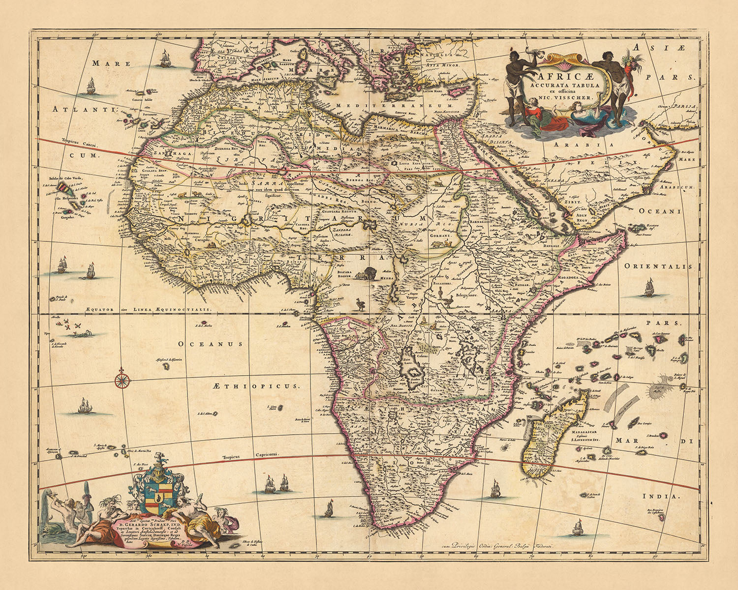
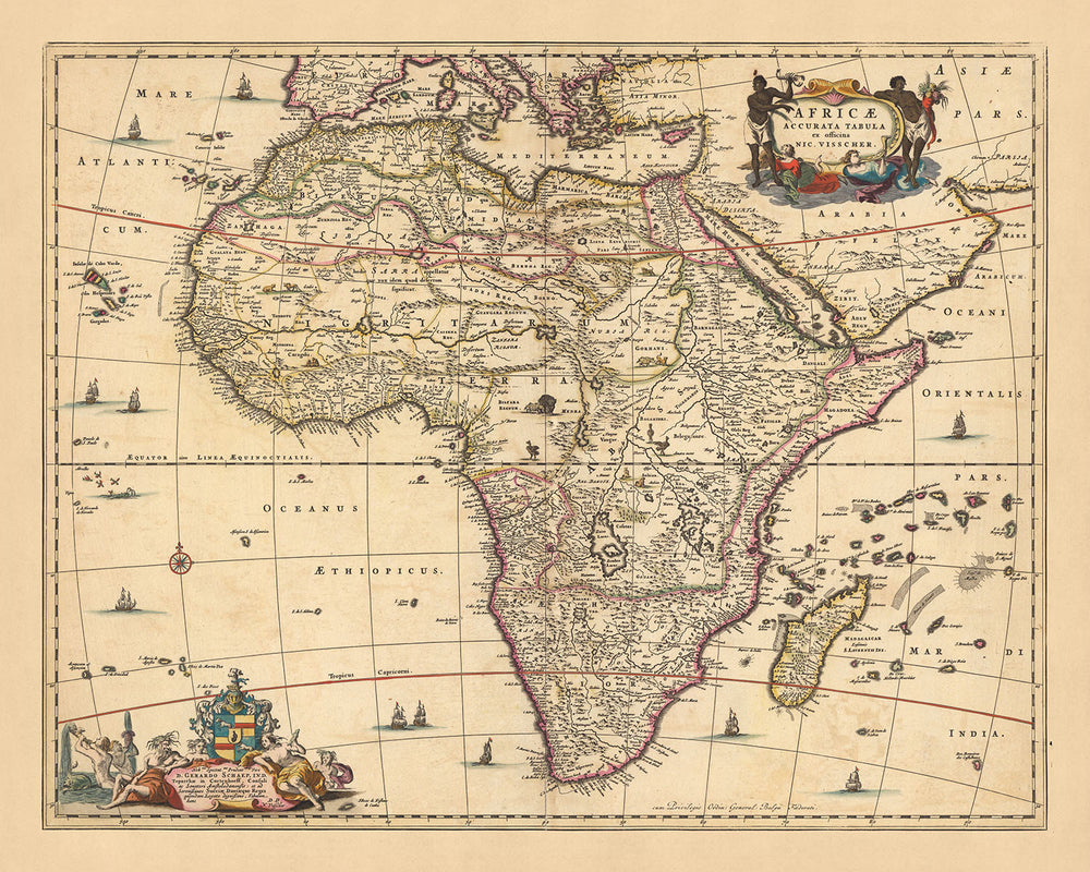


Antica mappa dell'Africa: 'Africae Accurata Tabula' di Visscher, 1690
Compra 2, Ricevi 1 Gratuito
Se aggiungi 2 articoli al tuo carrello, puoi aggiungere un terzo prodotto gratuitamente.
Questo vale per tutte le mappe e opere d'arte, comprese le opere personalizzate e su misura. Puoi ordinare 3 dello stesso articolo, o 3 articoli diversi.
Questo equivale a uno sconto del 33%, che sarà il maggiore sconto disponibile nel mio negozio quest'anno.
Ti prego di approfittare dell'offerta e di coprire le tue pareti con bellissime mappe e opere d'arte!
Contattami se hai domande.
- All taxes and duties included
- Handmade & dispatched in 1-2 days
-
FREE gift preview
ⓘ
Digital gift preview
After you complete your order, you can send a beautiful digital preview to the gift recipient. Just provide their email address and we'll do the rest. (Their email address will not be stored or used for any other purpose.)
This is perfect if you're concerned that your order might not arrive in time.
You can also buy a real non-expiring gift card, and email it directly to the recipient, so they can buy their own map or artwork.
-
90 day money back guarantee
ⓘ
90 giorni per restituire e ricevere un rimborso
I prodotti possono essere restituiti entro 90 giorni per un rimborso completo, o cambio con un altro prodotto.
Per articoli personalizzati e su misura, potremmo offrirti un credito in negozio o una carta regalo non scadente, poiché non possiamo rivendere ordini personalizzati.
Se hai domande, contattaci. Per ulteriori informazioni, consulta la nostra politica di restituzione e cambio.

My maps are rare, museum-grade, restored old maps sourced from libraries, auction houses and private collections across the globe.
Framing & free personalisation available
1. Select your size
Click here to order a custom size.
2. Frame & personalise your map
Make your map unique with framing, hand-drawn customisation, vintage ageing, pop art text, unique 3D styling and more.


Gift message & custom finish

If you want to add a gift message, or a finish (jigsaw, aluminium board, etc.) that is not available here, please request it in the "order note" when you check out.
Every order is custom made, so if you need the size adjusted slightly, or printed on an unusual material, just let us know. We've done thousands of custom orders over the years, so there's (almost) nothing we can't manage.
You can also contact us before you order, if you prefer!

- Handmade locally. No import duty or tax
- FREE worldwide delivery
- Love it or your money back (90 days)
- Questions? WhatsApp me any time
Own a piece of history
5,000+ 5 star reviews


Inizia un viaggio storico con l'Africae Accurata Tabula, una vecchia mappa dell'Africa meticolosamente realizzata da Nicolaes Visscher II nel 1690. Il titolo, tradotto in inglese, rivela lo scopo della mappa: fornire una 'Mappa Accurata dell'Africa'. Visscher, un discendente dell'illustre Età d'Oro olandese della cartografia, ha rappresentato in modo intricato i paesaggi geografici e politici dell'epoca. Questa mappa è più di una semplice rappresentazione topografica; è una testimonianza della maestria cartografica del XVII secolo e una finestra sul passato.
L'Africae Accurata Tabula comprende l'intero continente africano, insieme all'Europa meridionale, alla Penisola Arabica, a Madagascar e a diverse isole negli Oceani Atlantico e Indiano. Questa ampia copertura sottolinea l'ambizioso ambito della cartografia durante il tempo di Visscher. Ogni regione—Nord Africa, Africa Occidentale, Africa Orientale, Africa Centrale e Africa Meridionale—è rappresentata con straordinaria precisione, riflettendo l'impegno del cartografo per l'accuratezza e il dettaglio.
Questa mappa è un tesoro di informazioni storiche e geografiche. Illustra confini politici, città, paesi, corsi d'acqua, canali e punti di riferimento che erano significativi alla fine del XVII secolo. La mappa presenta anche una varietà diversificata di fauna selvatica e montagne, aumentando ulteriormente il suo fascino estetico. I contorni colorati a mano e i dettagli incisi aggiungono un tocco artistico all'accuratezza scientifica, mentre cartigli decorativi e una rosa dei venti contribuiscono al fascino storico della mappa.
L'Africae Accurata Tabula è più di una semplice mappa—è un artefatto storico, una testimonianza dell'arte e della conoscenza del suo creatore, e un'affascinante esplorazione di un'epoca passata. Questa mappa offre una prospettiva unica sul mondo come era compreso oltre tre secoli fa. Che tu sia un appassionato di storia, un entusiasta della cartografia o semplicemente qualcuno che apprezza l'intersezione tra arte e scienza, questa mappa è un'aggiunta affascinante a qualsiasi collezione.
Alcuni dei luoghi significativi mostrati su questa mappa:
Nord Africa: 1. Il Cairo, Egitto - Conosciuto come Al-Qāhirah, era la sede del Sultanato Mamluk e un importante centro di commercio e cultura. 2. Algeri, Algeria - Conosciuto come Al-Jazā’ir, era la capitale del Regno di Algeri, un importante centro dei Pirati Barbari. 3. Tunisi, Tunisia - La capitale del Sultanato Hafsidi, era un importante centro di commercio e apprendimento nel Mediterraneo. 4. Tripoli, Libia - Conosciuto come ṭarābulus, era un importante centro commerciale e amministrativo sotto il dominio ottomano. 5. Marrakech, Marocco - Conosciuto come Marrākiš, era una grande città imperiale del Marocco.
Africa Occidentale: 1. Timbuktu, Mali - Una capitale intellettuale e spirituale e un centro per la propagazione dell'Islam in tutta l'Africa nei secoli XV e XVI. 2. Dakar, Senegal - Conosciuto come Ndakaaru, era una città importante nel Regno di Cayor. 3. Kumasi, Ghana - La capitale dell'Impero Ashanti, nota per il suo commercio d'oro e avorio. 4. Kano, Nigeria - Un importante centro di studi islamici Hausa. 5. Ouagadougou, Burkina Faso - La capitale dei Regni Mossi.
Africa Orientale: 1. Mombasa, Kenya - Una importante città-stato swahili nota per il suo commercio di avorio e schiavi. 2. Mogadishu, Somalia - Conosciuta come Maqdishu, era la capitale del Sultanato Ajuran, un centro commerciale e culturale notevole. 3. Harar, Etiopia - Considerata la quarta città più sacra dell'Islam. 4. Zanzibar City, Tanzania - Conosciuta come Unguja, era una significativa città-stato commerciale sotto il Sultanato di Zanzibar. 5. Antananarivo, Madagascar - Conosciuta come Analamanga, era la capitale del Regno di Imerina.
Africa Centrale: 1. Kinshasa, RD Congo - Conosciuta come Mbanza-Kongo, era la capitale del Regno del Kongo. 2. Luanda, Angola - Fondata dai portoghesi, era un importante centro del commercio di schiavi atlantico. 3. Bangui, Repubblica Centrafricana - Un importante avamposto commerciale sul fiume Ubangi. 4. Brazzaville, Repubblica del Congo - Conosciuta come Mfoa, era una città significativa nel Regno del Kongo. 5. N'Djamena, Ciad - Conosciuta come N'Djamena, era una grande città nel Sultanato di Bagirmi.
Africa Meridionale: 1. Cape Town, Sudafrica - Conosciuta come Kaapstad, era una stazione di rifornimento per le navi olandesi che viaggiavano verso l'Africa orientale, l'India e l'Estremo Oriente. 2. Maputo, Mozambico - Conosciuta come Lourenço Marques, era un importante avamposto commerciale portoghese. 3. Maseru, Lesotho - Una città importante nel Regno del Lesotho. 4. Gaborone, Botswana - Conosciuta come Gaberones, era una grande città nel Protettorato del Bechuanaland. 5. Windhoek, Namibia - Conosciuta come ǀAiǁgams, era una grande città nei Regni Herero.
Fenomeni naturali e attrazioni notevoli: 1. Il fiume Nilo - Il fiume più lungo d'Africa, noto per il suo ruolo nella civiltà dell'antico Egitto. 2. Il deserto del Sahara - Il più grande deserto caldo del mondo, noto per i suoi paesaggi unici. 3. Le Cascate Vittoria - Situate sul fiume Zambesi, sono una delle cascate più grandi del mondo. 4. La Grande Rift Valley - Una caratteristica geologica notevole che attraversa diversi paesi dell'Africa orientale. 5. Il Delta dell'Okavango - Un grande delta interno in Botswana, noto per la sua ricca fauna selvatica.
Eventi storici notevoli tra il 1600 e il 1690: 1. La Battaglia di Mbwila (1665) - Un conflitto tra il Regno del Portogallo e il Regno del Kongo, che ha portato alla morte del re del Kongo. 2. Il periodo di Gondar in Etiopia (1632-1755) - Contrassegnato dal regno dell'Imperatore Fasilides e dalla costruzione della città fortificata di Fasil Ghebbi. 3. L'istituzione della Colonia olandese del Capo (1652) - La Compagnia delle Indie Orientali olandesi stabilì una colonia al Capo di Buona Speranza come punto di rifornimento per le navi.
Si prega di controllare attentamente le immagini per assicurarsi che una specifica città o luogo sia mostrato su questa mappa. Puoi anche contattarci e chiedere di controllare la mappa per te.
Questa mappa appare fantastica in tutte le dimensioni: 12x16in (30.5x41cm), 16x20in (40.5x51cm), 18x24in (45.5x61cm), 24x30in (61x76cm), 32x40in (81.5x102cm), 40x50in (102x127cm), 48x60in (122x153cm) e 56x70in (142x178cm), ma appare ancora meglio se stampata in grande.
Posso creare bellissime stampe di questa mappa fino a 90in (229cm). Si prega di contattarmi se stai cercando opzioni di stampa più grandi, personalizzate o diverse.
Il modello nelle immagini dell'elenco tiene la versione 16x20in (40.5x51cm) di questa mappa.
La quinta immagine dell'elenco mostra un esempio del mio servizio di personalizzazione della mappa.
Se stai cercando qualcosa di leggermente diverso, dai un'occhiata alla mia collezione delle migliori vecchie mappe d'Europa e delle città europee per vedere se qualcosa d'altro attira la tua attenzione.
Per favore contattami per verificare se una certa posizione, punto di riferimento o caratteristica è mostrata su questa mappa.
Questo sarebbe un meraviglioso regalo per un compleanno, Natale, Festa del Papà, festa di pensionamento, anniversario o inaugurazione della casa per qualcuno delle aree coperte da questa mappa.
Questa mappa è disponibile come stampa giclée su carta opaca archiviata senza acidi, oppure puoi acquistarla incorniciata. La cornice è una semplice cornice nera che si adatta alla maggior parte degli stili. Per favore mettiti in contatto se desideri un colore o materiale diverso per la cornice. Le mie cornici sono rivestite con un acrilico di grado museo super chiaro (perspex/acrylite), che è significativamente meno riflettente del vetro, più sicuro e arriverà sempre in perfette condizioni.
This map is also available as a float framed canvas, sometimes known as a shadow gap framed canvas or canvas floater. The map is printed on artist's cotton canvas and then stretched over a handmade box frame. We then "float" the canvas inside a wooden frame, which is available in a range of colours (black, dark brown, oak, antique gold and white). This is a wonderful way to present a map without glazing in front. See some examples of float framed canvas maps and explore the differences between my different finishes.
For something truly unique, this map is also available in "Unique 3D", our trademarked process that dramatically transforms the map so that it has a wonderful sense of depth. We combine the original map with detailed topography and elevation data, so that mountains and the terrain really "pop". For more info and examples of 3D maps, check my Unique 3D page.
For most orders, delivery time is about 3 working days. Personalised and customised products take longer, as I have to do the personalisation and send it to you for approval, which usually takes 1 or 2 days.
Please note that very large framed orders usually take longer to make and deliver.
If you need your order to arrive by a certain date, please contact me before you order so that we can find the best way of making sure you get your order in time.
I print and frame maps and artwork in 23 countries around the world. This means your order will be made locally, which cuts down on delivery time and ensures that it won't be damaged during delivery. You'll never pay customs or import duty, and we'll put less CO2 into the air.
All of my maps and art prints are well packaged and sent in a rugged tube if unframed, or surrounded by foam if framed.
I try to send out all orders within 1 or 2 days of receiving your order, though some products (like face masks, mugs and tote bags) can take longer to make.
If you select Express Delivery at checkout your order we will prioritise your order and send it out by 1-day courier (Fedex, DHL, UPS, Parcelforce).
Next Day delivery is also available in some countries (US, UK, Singapore, UAE) but please try to order early in the day so that we can get it sent out on time.
My standard frame is a gallery style black ash hardwood frame. It is simple and quite modern looking. My standard frame is around 20mm (0.8in) wide.
I use super-clear acrylic (perspex/acrylite) for the frame glass. It's lighter and safer than glass - and it looks better, as the reflectivity is lower.
Six standard frame colours are available for free (black, dark brown, dark grey, oak, white and antique gold). Custom framing and mounting/matting is available if you're looking for something else.
Most maps, art and illustrations are also available as a framed canvas. We use matte (not shiny) cotton canvas, stretch it over a sustainably sourced box wood frame, and then 'float' the piece within a wood frame. The end result is quite beautiful, and there's no glazing to get in the way.
All frames are provided "ready to hang", with either a string or brackets on the back. Very large frames will have heavy duty hanging plates and/or a mounting baton. If you have any questions, please get in touch.
See some examples of my framed maps and framed canvas maps.
Alternatively, I can also supply old maps and artwork on canvas, foam board, cotton rag and other materials.
If you want to frame your map or artwork yourself, please read my size guide first.
Alcune delle mie vecchie mappe sono ora disponibili come tele incorniciate. Per favore contattami se desideri ordinare una dimensione che non è disponibile nel mio negozio.
Le vecchie mappe su tela sono un'alternativa interessante alle mappe incorniciate in modo convenzionale. A seconda del tuo gusto personale e dell'arredamento della stanza, le mappe su tela possono "risaltare" un po' di più rispetto a una mappa incorniciata.
My maps are extremely high quality reproductions of original maps.
I source original, rare maps from libraries, auction houses and private collections around the world, restore them at my London workshop, and then use specialist giclée inks and printers to create beautiful maps that look even better than the original.
My maps are printed on acid-free archival matte (not glossy) paper that feels very high quality and almost like card. In technical terms the paper weight/thickness is 10mil/200gsm. It's perfect for framing.
I print with Epson ultrachrome giclée UV fade resistant pigment inks - some of the best inks you can find.
I can also make maps on canvas, cotton rag and other exotic materials.
Learn more about The Unique Maps Co.
Map personalisation
If you're looking for the perfect anniversary or housewarming gift, I can personalise your map to make it truly unique. For example, I can add a short message, or highlight an important location, or add your family's coat of arms.
The options are almost infinite. Please see my map personalisation page for some wonderful examples of what's possible.
To order a personalised map, select "personalise your map" before adding it to your basket.
Get in touch if you're looking for more complex customisations and personalisations.
Map ageing
I have been asked hundreds of times over the years by customers if they could buy a map that looks even older.
Well, now you can, by selecting Aged before you add a map to your basket.
All the product photos you see on this page show the map in its Original form. This is what the map looks like today.
If you select Aged, I will age your map by hand, using a special and unique process developed through years of studying old maps, talking to researchers to understand the chemistry of aging paper, and of course... lots of practice!
If you're unsure, stick to the Original colour of the map. If you want something a bit darker and older looking, go for Aged.
Se non sei soddisfatto del tuo ordine per qualsiasi motivo, contattami per un rimborso senza problemi. Si prega di consultare la nostra politica di reso e rimborso per ulteriori informazioni.
Sono molto sicuro che ti piacerà la tua mappa restaurata o la stampa d'arte. Lo faccio dal 1984. Sono un venditore Etsy a 5 stelle. Ho venduto decine di migliaia di mappe e stampe d'arte e ho oltre 5.000 recensioni reali a 5 stelle.
Utilizzo un processo unico per restaurare mappe e opere d'arte che richiede molto tempo e lavoro. Trovare le mappe e le illustrazioni originali può richiedere mesi. Utilizzo tecnologia all'avanguardia e incredibilmente costosa per scannerizzare e restaurarle. Di conseguenza, garantisco che le mie mappe e stampe d'arte siano superiori alle altre - ecco perché posso offrire un rimborso senza problemi.
Quasi tutte le mie mappe e stampe d'arte sembrano fantastiche a grandi dimensioni (200 cm, 6,5 piedi+) e posso anche incorniciarle e consegnarle a te, tramite un corriere speciale per oggetti di grandi dimensioni. Contattami per discutere delle tue esigenze specifiche.
Or try searching for something!


