


Vecchia mappa pittorica del Delhi Durbar di Wymer, 1911: Padiglione della coronazione, Parco, Kingsway, Reggimenti, Elefanti
- All taxes and duties included
- Handmade & dispatched in 1-2 days
-
90 day money back guarantee
ⓘ
90 giorni per restituire e ricevere un rimborso
I prodotti possono essere restituiti entro 90 giorni per un rimborso completo, o cambio con un altro prodotto.
Per articoli personalizzati e su misura, potremmo offrirti un credito in negozio o una carta regalo non scadente, poiché non possiamo rivendere ordini personalizzati.
Se hai domande, contattaci. Per ulteriori informazioni, consulta la nostra politica di restituzione e cambio.

My maps are rare, museum-grade, restored old maps sourced from libraries, auction houses and private collections across the globe.
Framing & free personalisation available
1. Select your size
2. Frame & personalise your map
There is limited framing & personalisation capacity available. Order by 10am tomorrow for Christmas delivery.


Gift message & custom finish

If you want to add a gift message, or a finish (jigsaw, aluminium board, etc.) that is not available here, please request it in the "order note" when you check out.
Every order is custom made, so if you need the size adjusted slightly, or printed on an unusual material, just let us know. We've done thousands of custom orders over the years, so there's (almost) nothing we can't manage.
You can also contact us before you order, if you prefer!

- Handmade locally. No import duty or tax
- FREE Delivery by Christmas
- Love it or your money back (90 days)
- Questions? WhatsApp me any time
Own a piece of history
5,000+ 5 star reviews


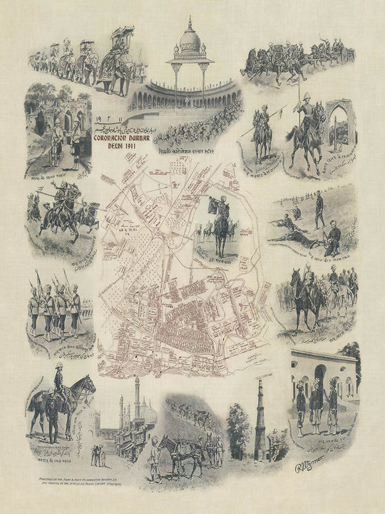
La mappa "Delhi Durbar, 1911", creata dal rinomato pittore militare e illustratore Reginald Augustus Wymer, è un pezzo affascinante che commemora un evento fondamentale nella storia dell'India britannica. Questa mappa, originariamente realizzata per segnare il grande Delhi Durbar del 1911, offre uno sguardo dettagliato ed evocativo nel cuore della Delhi coloniale durante l'apice dell'Impero britannico. Il Durbar, a cui parteciparono l'Imperatore Giorgio V e l'Imperatrice Regina Mary, fu una grande assemblea al Coronation Park, celebrando la successione del sovrano.
Questa mappa della città è notevole per la sua intricata rappresentazione di quartieri e punti di riferimento significativi che erano centrali per il Delhi Durbar. Il Padiglione della Coronazione, una caratteristica chiave del Durbar, si erge in modo prominente, simboleggiando la grandezza imperiale dell'evento. Attorno alla mappa ci sono illustrazioni dettagliate di vari reggimenti, tra cui i Cameron Highlanders della Regina e i Gurkha Rifles del 1° Re Giorgio, che mostrano la potenza militare e lo splendore cerimoniale dell'Impero britannico. Questi elementi visivi non solo migliorano l'appeal estetico della mappa, ma forniscono anche una comprensione più profonda del contesto storico e delle dinamiche culturali della Delhi dei primi del '900.
L'arte di Wymer si estende oltre la semplice cartografia; cattura l'essenza della vita coloniale indiana attraverso vividi scenari di vita di villaggio, processioni di elefanti e sentieri per muli. Queste illustrazioni offrono una finestra sulle attività quotidiane e le pratiche cerimoniali che definivano il periodo. La rappresentazione di vari scenari di battaglia e attività militari sottolinea ulteriormente l'importanza strategica di Delhi come roccaforte coloniale. Ogni elemento è meticolosamente reso, riflettendo la rinomata accuratezza di Wymer e la sua abilità di dare vita alle narrazioni storiche attraverso la sua arte.
La mappa mette anche in evidenza la complessa rete di strade e vie della città, con importanti arterie come Kingsway, Queen's Road e Victoria Road ben etichettate. Queste strade, intrise di storia, collegano varie parti della città e conducono a siti significativi come il Coronation Park e altri centri militari e amministrativi. La rappresentazione dettagliata di queste strade fornisce preziose intuizioni sulla pianificazione urbana e l'infrastruttura di Delhi durante il Raj britannico, rendendola una risorsa essenziale per storici e appassionati di storia coloniale.
Oltre al suo significato storico, la mappa "Delhi Durbar, 1911" è una testimonianza della maestria artistica di Wymer e del suo contributo al campo dell'illustrazione militare. Le sue opere, raccolte dalla stessa Regina Vittoria, sono celebrate per la loro precisione e accuratezza storica. Questa mappa, con il suo ricco contenuto visivo e storico, rappresenta un esempio straordinario dell'eredità di Wymer, offrendo una miscela unica di dettaglio cartografico ed espressione artistica. Non è solo una mappa, ma un documento storico che racchiude la grandezza e la complessità del Delhi Durbar, rendendola un possesso prezioso per collezionisti e appassionati di storia.
Strade e vie su questa mappa
- Alexandra Road
- Alipore Road
- Barrack Road
- Cavalry Road
- Edward Road
- Flagstaff Road
- Hospital Road
- Jail Road
- Avenue di Re Giorgio
- Kingsway
- Lothian Road
- Magazine Road
- Mall Road
- Military Road
- Strada Nicholson
- Strada North
- Strada Parade
- Strada della Regina
- Strada Rajpura
- Strada Ridge
- Strada Roshanara
- Strada Shalimar
- Strada Smith
- Strada Subzi Mandi
- Strada Victoria
Caratteristiche e Luoghi Notabili
- Illustrazioni:
- Processione di elefanti
- Vari reggimenti, inclusi i Cameron Highlanders della Regina e i 1° Gurkha Rifles del Re Giorgio
- Scena di villaggio
- Sentiero per muli
- Scene di battaglia
- Pavillon della Coronazione
- Cavalieri e soldati in varie attività
- Luoghi Notabili:
- Pavillon della Coronazione
- Grandi parchi:
- Parco della Coronazione
Contesto Storico e di Design
- Mappa affascinante di una porzione della città di Delhi, che commemora il Delhi Durbar.
- Originariamente stampata su lino, conferendole una texture interessante.
- La mappa mostra una piccola parte di Delhi, circondata da belle illustrazioni del Durbar.
- Il Delhi Durbar era un'assemblea di massa al Parco della Coronazione, Delhi, India, per segnare la successione di un Imperatore.
- Conosciuto anche come Imperial Durbar, si è tenuto tre volte: nel 1877, 1903 e 1911, all'apice dell'Impero Britannico.
- Il Durbar del 1911 è stato l'unico a cui ha partecipato il sovrano, Giorgio V e la Regina Maria come Imperatore e Imperatrice dell'India.
- Questa mappa era originariamente un fazzoletto stampato con una mappa dettagliata del parco, in inchiostro marrone, con la propria stazione ferroviaria e scene affascinanti della vita coloniale indiana.
- Creato da Reginald Augustus Wymer, un pittore e illustratore militare.
- Le opere di Wymer erano rinomate per la loro accuratezza e furono raccolte dalla Regina Vittoria.
- La mappa include scene dalla vita coloniale indiana, come i Cameron Highlanders della Regina, i 1° Gurkha Rifles del Re Giorgio e molti altri reggimenti.
- Illustrazioni di una scena di villaggio, una processione di elefanti, un sentiero per muli e scene di battaglia.
- Una piccola parte di Delhi, India, è rappresentata.
- La mappa è una mappa tematica e pittorica della città.
- Le illustrazioni circostanti rappresentano varie scene relative al Delhi Durbar e alla vita coloniale indiana.
- La mappa commemora il Delhi Durbar del 1911, un evento significativo che segna la successione di un Imperatore.
- Fornisce un'istantanea storica dell'India coloniale durante l'Impero Britannico.
Si prega di controllare attentamente le immagini per assicurarsi che una specifica città o luogo sia mostrato su questa mappa. Puoi anche contattarci e chiedere di controllare la mappa per te.
Questa mappa appare fantastica in ogni dimensione, ma consiglio sempre di optare per una dimensione più grande se hai spazio. In questo modo puoi facilmente distinguere tutti i dettagli.
Questa mappa sembra incredibile in dimensioni fino a 50 pollici (125 cm). Se stai cercando una mappa più grande, per favore contattaci.
Si prega di notare: le etichette su questa mappa sono difficili da leggere se ordini una mappa di 20 pollici (50 cm) o più piccola. La mappa è comunque molto attraente, ma se desideri leggere facilmente la mappa, ti preghiamo di acquistare una dimensione più grande.
Il modello nelle immagini dell'inserzione tiene la versione di questa mappa 16x20 pollici (40x50 cm).
La quinta immagine dell'inserzione mostra un esempio del mio servizio di personalizzazione della mappa.
Se stai cercando qualcosa di leggermente diverso, dai un'occhiata alla mia collezione delle migliori mappe antiche per vedere se qualcosa attira la tua attenzione.
Per favore contattami per verificare se una certa posizione, un punto di riferimento o una caratteristica è mostrata su questa mappa.
Questo sarebbe un meraviglioso regalo di compleanno, Natale, Festa del Papà, addio al lavoro, anniversario o inaugurazione della casa per qualcuno delle aree coperte da questa mappa.
Questa mappa è disponibile come stampa giclée su carta opaca archiviabile senza acidi, oppure puoi acquistarla incorniciata. La cornice è una bella e semplice cornice nera che si adatta alla maggior parte degli stili. Per favore, mettiti in contatto se desideri un colore o un materiale diverso per la cornice. Le mie cornici sono rivestite con acrilico museo super chiaro (perspex/acrylite), che è significativamente meno riflettente del vetro, più sicuro e arriverà sempre in perfette condizioni.
This map is also available as a float framed canvas, sometimes known as a shadow gap framed canvas or canvas floater. The map is printed on artist's cotton canvas and then stretched over a handmade box frame. We then "float" the canvas inside a wooden frame, which is available in a range of colours (black, dark brown, oak, antique gold and white). This is a wonderful way to present a map without glazing in front. See some examples of float framed canvas maps and explore the differences between my different finishes.
For something truly unique, this map is also available in "Unique 3D", our trademarked process that dramatically transforms the map so that it has a wonderful sense of depth. We combine the original map with detailed topography and elevation data, so that mountains and the terrain really "pop". For more info and examples of 3D maps, check my Unique 3D page.
For most orders, delivery time is about 3 working days. Personalised and customised products take longer, as I have to do the personalisation and send it to you for approval, which usually takes 1 or 2 days.
Please note that very large framed orders usually take longer to make and deliver.
If you need your order to arrive by a certain date, please contact me before you order so that we can find the best way of making sure you get your order in time.
I print and frame maps and artwork in 23 countries around the world. This means your order will be made locally, which cuts down on delivery time and ensures that it won't be damaged during delivery. You'll never pay customs or import duty, and we'll put less CO2 into the air.
All of my maps and art prints are well packaged and sent in a rugged tube if unframed, or surrounded by foam if framed.
I try to send out all orders within 1 or 2 days of receiving your order, though some products (like face masks, mugs and tote bags) can take longer to make.
If you select Express Delivery at checkout your order we will prioritise your order and send it out by 1-day courier (Fedex, DHL, UPS, Parcelforce).
Next Day delivery is also available in some countries (US, UK, Singapore, UAE) but please try to order early in the day so that we can get it sent out on time.
My standard frame is a gallery style black ash hardwood frame. It is simple and quite modern looking. My standard frame is around 20mm (0.8in) wide.
I use super-clear acrylic (perspex/acrylite) for the frame glass. It's lighter and safer than glass - and it looks better, as the reflectivity is lower.
Six standard frame colours are available for free (black, dark brown, dark grey, oak, white and antique gold). Custom framing and mounting/matting is available if you're looking for something else.
Most maps, art and illustrations are also available as a framed canvas. We use matte (not shiny) cotton canvas, stretch it over a sustainably sourced box wood frame, and then 'float' the piece within a wood frame. The end result is quite beautiful, and there's no glazing to get in the way.
All frames are provided "ready to hang", with either a string or brackets on the back. Very large frames will have heavy duty hanging plates and/or a mounting baton. If you have any questions, please get in touch.
See some examples of my framed maps and framed canvas maps.
Alternatively, I can also supply old maps and artwork on canvas, foam board, cotton rag and other materials.
If you want to frame your map or artwork yourself, please read my size guide first.
Alcune delle mie vecchie mappe sono ora disponibili come tele incorniciate. Per favore contattami se desideri ordinare una dimensione che non è disponibile nel mio negozio.
Le vecchie mappe su tela sono un'alternativa interessante alle mappe incorniciate in modo convenzionale. A seconda del tuo gusto personale e dell'arredamento della stanza, le mappe su tela possono "risaltare" un po' di più rispetto a una mappa incorniciata.
My maps are extremely high quality reproductions of original maps.
I source original, rare maps from libraries, auction houses and private collections around the world, restore them at my London workshop, and then use specialist giclée inks and printers to create beautiful maps that look even better than the original.
My maps are printed on acid-free archival matte (not glossy) paper that feels very high quality and almost like card. In technical terms the paper weight/thickness is 10mil/200gsm. It's perfect for framing.
I print with Epson ultrachrome giclée UV fade resistant pigment inks - some of the best inks you can find.
I can also make maps on canvas, cotton rag and other exotic materials.
Learn more about The Unique Maps Co.
Map personalisation
If you're looking for the perfect anniversary or housewarming gift, I can personalise your map to make it truly unique. For example, I can add a short message, or highlight an important location, or add your family's coat of arms.
The options are almost infinite. Please see my map personalisation page for some wonderful examples of what's possible.
To order a personalised map, select "personalise your map" before adding it to your basket.
Get in touch if you're looking for more complex customisations and personalisations.
Map ageing
I have been asked hundreds of times over the years by customers if they could buy a map that looks even older.
Well, now you can, by selecting Aged before you add a map to your basket.
All the product photos you see on this page show the map in its Original form. This is what the map looks like today.
If you select Aged, I will age your map by hand, using a special and unique process developed through years of studying old maps, talking to researchers to understand the chemistry of aging paper, and of course... lots of practice!
If you're unsure, stick to the Original colour of the map. If you want something a bit darker and older looking, go for Aged.
Se non sei soddisfatto del tuo ordine per qualsiasi motivo, contattami per un rimborso senza problemi. Si prega di consultare la nostra politica di reso e rimborso per ulteriori informazioni.
Sono molto sicuro che ti piacerà la tua mappa restaurata o la stampa d'arte. Lo faccio dal 1984. Sono un venditore Etsy a 5 stelle. Ho venduto decine di migliaia di mappe e stampe d'arte e ho oltre 5.000 recensioni reali a 5 stelle.
Utilizzo un processo unico per restaurare mappe e opere d'arte che richiede molto tempo e lavoro. Trovare le mappe e le illustrazioni originali può richiedere mesi. Utilizzo tecnologia all'avanguardia e incredibilmente costosa per scannerizzare e restaurarle. Di conseguenza, garantisco che le mie mappe e stampe d'arte siano superiori alle altre - ecco perché posso offrire un rimborso senza problemi.
Quasi tutte le mie mappe e stampe d'arte sembrano fantastiche a grandi dimensioni (200 cm, 6,5 piedi+) e posso anche incorniciarle e consegnarle a te, tramite un corriere speciale per oggetti di grandi dimensioni. Contattami per discutere delle tue esigenze specifiche.
Or try searching for something!


