

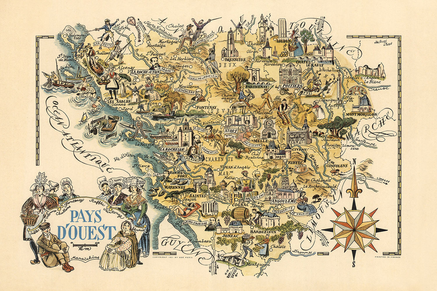


Mappa Pittorica Antica di Poitou-Charentes di Liozu, 1951: La Rochelle, Poitiers, Angoulême, Marais Poitevin
20% di sconto su 2 — 33% di sconto su 3
Aggiungi qualsiasi due articoli idonei al tuo carrello per ricevere 20% di sconto. Aggiungi un terzo e sarà gratuito (equivalente a 33% di sconto quando acquisti tre).
Nessun codice necessario — l'offerta si applica automaticamente al checkout.
Valido su tutte le mappe standard e le stampe d'arte fine. Puoi mescolare e abbinare qualsiasi design.
Se desideri spedire articoli a più indirizzi, ti preghiamo di contattarci prima di effettuare il tuo ordine.
Le commissioni personalizzate e su misura sono escluse.
Contattaci se hai domande
- All taxes and duties included
- Handmade & dispatched in 1-2 days
-
Complimentary gifting & design advice
ⓘ
Complimentary gifting & design advice
Available almost 24/7 on WhatsApp and email — we usually reply within minutes. We can help you:
- Choose a perfectly personalised gift
- Send a digital gift preview to the recipient
- Pick the ideal size for your wall
- Select the right finish and frame
Quick, friendly advice so you can order with confidence.
For last minute gifts, consider buying a digital gift card. We have over 5,000 maps and art prints to choose from.
-
90-day returns & 5-year guarantee
ⓘ
90 giorni per restituire e ricevere un rimborso
I prodotti possono essere restituiti entro 90 giorni per un rimborso completo, o cambio con un altro prodotto.
Per articoli personalizzati e su misura, potremmo offrirti un credito in negozio o una carta regalo non scadente, poiché non possiamo rivendere ordini personalizzati.
Se hai domande, contattaci. Per ulteriori informazioni, consulta la nostra politica di restituzione e cambio.

This is a museum-grade archival print from the original 1951 map — restored in our workshop and made to order on 220gsm archival matte paper or 400gsm artist's cotton canvas with pigment inks.
Beautifully framed and ready to hang, with complimentary personalisation available.
1. Choose a size
2. Frame & personalise your map
Make your map unique with framing, hand-drawn customisation, vintage ageing, pop art text, unique 3D styling and more.


Gift message & custom finish

If you want to add a gift message, or a finish (jigsaw, aluminium board, etc.) that is not available here, please request it in the "order note" when you check out.
Every order is custom made, so if you need the size adjusted slightly, or printed on an unusual material, just let us know. We've done thousands of custom orders over the years, so there's (almost) nothing we can't manage.
You can also contact us before you order, if you prefer!

- Handmade locally. No import duty or tax
- FREE worldwide delivery
- 90-day returns & 5-year product guarantee
- Questions? WhatsApp me any time
Own a piece of history
7,000+ 5 star reviews


Entra nel mondo affascinante della cartografia della metà del XX secolo con la mappa "Pays d'Ouest", meticulosamente realizzata dal stimato Jacques Liozu nel 1951. Questa mappa pittorica a colori cattura elegantemente l'essenza delle regioni occidentali della Francia, in particolare Poitou-Charentes e la parte meridionale del Pays de la Loire. L'arte magistrale di Liozu dà vita al ricco arazzo di questa regione storica, offrendo un banchetto visivo che è sia informativo che esteticamente piacevole. La rosa dei venti decorativa, un marchio di fabbrica del lavoro di Liozu, non solo funge da aiuto alla navigazione ma aggiunge anche un tocco di flair artistico, rendendo questa mappa un vero pezzo da collezione.
Jacques Liozu, rinomato per le sue mappe dettagliate e artisticamente ricche, ha infuso il "Pays d'Ouest" con una ricchezza di elementi storici e culturali. La mappa è un tesoro di monumenti storici, dal imponente Château de Saumur al leggendario Château de Chinon. Ogni monumento è illustrato in modo intricato, fornendo uno sguardo sulla grandezza architettonica e sul significato storico di questi luoghi. Il lavoro di Liozu trascende la mera cartografia, offrendo una narrativa che collega lo spettatore con la ricca storia e il patrimonio culturale della regione.
La mappa "Pays d'Ouest" non è solo una rappresentazione geografica; è un vivace tableau delle meraviglie naturali e artificiali della regione. La mappa mette in mostra parchi nazionali come il Parc Naturel Régional du Marais Poitevin, evidenziando l'impegno della regione a preservare la sua bellezza naturale. Fiumi, montagne e altri fenomeni naturali sono rappresentati con un rilievo pittorico, aggiungendo profondità e dimensione alla mappa. Questo approccio artistico consente agli spettatori di apprezzare i paesaggi diversi che definiscono le regioni occidentali della Francia.
La mappa di Liozu funge anche da documento storico, catturando eventi significativi che hanno plasmato la regione. La Battaglia di Poitiers nel 732 e l'Assedio di La Rochelle nel 1627-1628 sono tra i notevoli eventi storici illustrati sulla mappa. Queste rappresentazioni forniscono contesto e profondità, arricchendo la comprensione dello spettatore del passato turbolento della regione. Intrecciando eventi storici con caratteristiche geografiche, Liozu offre una narrativa completa e coinvolgente che attrae sia gli appassionati di storia che gli spettatori occasionali.
Le città e i paesi rappresentati sulla mappa "Pays d'Ouest" sono una testimonianza della vita urbana e rurale vibrante della regione. Dalla vivace città di Nantes al pittoresco paese di La Rochelle, ogni insediamento è illustrato con cura, riflettendo il suo carattere unico e significato. La mappa evidenzia anche paesi più piccoli come Fontenay-le-Comte e Challans, assicurando che nessun dettaglio venga trascurato. Questo approccio completo rende la mappa "Pays d'Ouest" non solo un'opera d'arte bellissima ma anche una risorsa inestimabile per chiunque sia interessato alla geografia e alla storia della Francia occidentale.
Città e paesi su questa mappa
- Pays de la Loire:
- La Roche-sur-Yon
- Cholet
- Les Sables-d'Olonne
- Fontenay-le-Comte
- Montaigu
-
Les Herbiers
-
Poitou-Charentes:
- Poitiers
- La Rochelle
- Niort
- Angoulême
- Châtellerault
- Rochefort
- Saintes
- Royan
- Cognac
- Thouars
- Parthenay
- Ruffec
- Montmorillon
- Melle
- Civray
- Confolens
- Barbezieux
- Jonzac
Caratteristiche e monumenti notevoli
- Luoghi storici:
- Castello di Saumur
- Castello di Chinon
- Castello di Montsoreau
- Castello di Brézé
- Castello di Thouars
- Castello di Angers
- Castello di Nantes
- Castello di Clisson
- Castello di Tiffauges
- Castello di La Rochefoucauld
- Castello di Javarzay
- Castello di La Roche Courbon
-
Castello di Crazannes
-
Parchi nazionali e principali:
- Parco Naturale Regionale del Marais Poitevin
-
Eventi storici:
- Battaglia di Poitiers (732)
- Assedio di La Rochelle (1627-1628)
Contesto storico e di design
- Nome della mappa: Pays d'Ouest
- Data di creazione: 1951
- Cartografo/Editore: Jacques Liozu
- Mappa pittorica a colori: La mappa è colorata e illustrata, fornendo una rappresentazione visiva delle regioni occidentali.
- Regioni rappresentate: Include alcune parti del Pays de la Loire, una regione in Francia, e Poitou-Charentes.
- Rosone decorativo: La mappa presenta un rosone ornato, aumentando il suo fascino decorativo.
- Rilievo mostrato in modo pittorico: La mappa utilizza illustrazioni per rappresentare il terreno e le caratteristiche del paesaggio.
- Temi e argomenti:
- Rappresentazione storica e culturale: La mappa include vari luoghi storici, icone culturali ed eventi notevoli.
- Elementi pittorici: Illustrazioni di persone, animali e attività forniscono approfondimenti sulla cultura e la storia della regione.
- Design e stile:
- Elementi artistici e tematici: La mappa è ricca di dettagli artistici, combinando funzionalità con narrazione visiva.
- Significato storico: La mappa offre uno sguardo sul paesaggio culturale e storico della regione a metà del XX secolo.
Si prega di controllare le immagini per assicurarsi che una specifica città o luogo sia mostrato su questa mappa. È possibile anche contattarci e chiedere di controllare la mappa per voi.
Questa mappa appare fantastica in ogni formato, ma consiglio sempre di optare per una dimensione più grande se si ha spazio. In questo modo si possono facilmente distinguere tutti i dettagli.
Questa mappa appare incredibile in dimensioni fino a 70 pollici (180 cm). Se stai cercando una mappa più grande, ti preghiamo di contattarci.
Il modello nelle immagini dell'elenco tiene in mano la versione 24x36 pollici (60x90 cm) di questa mappa.
La quinta immagine dell'elenco mostra un esempio del mio servizio di personalizzazione della mappa.
Se stai cercando qualcosa di leggermente diverso, dai un'occhiata alla mia collezione delle migliori vecchie mappe per vedere se qualcosa attira la tua attenzione.
Si prega di contattarmi per verificare se una certa posizione, punto di riferimento o caratteristica è mostrata su questa mappa.
Questo sarebbe un regalo meraviglioso per un compleanno, Natale, Festa del Papà, un congedo dal lavoro, un anniversario o una festa di inaugurazione per qualcuno delle aree coperte da questa mappa.
Questa mappa è disponibile come stampa giclée su carta opaca archiviata senza acidi, oppure puoi acquistarla incorniciata. La cornice è una bella e semplice cornice nera che si adatta alla maggior parte degli stili. Ti preghiamo di contattarci se desideri un colore o un materiale diverso per la cornice. Le mie cornici sono rivestite con acrilico di grado museale super chiaro (perspex/acrylite), che è significativamente meno riflettente del vetro, più sicuro e arriverà sempre in perfette condizioni.
This map is also available as a float framed canvas, sometimes known as a shadow gap framed canvas or canvas floater. The map is printed on artist's cotton canvas and then stretched over a handmade box frame. We then "float" the canvas inside a wooden frame, which is available in a range of colours (black, dark brown, oak, antique gold and white). This is a wonderful way to present a map without glazing in front. See some examples of float framed canvas maps and explore the differences between my different finishes.
For something truly unique, this map is also available in "Unique 3D", our trademarked process that dramatically transforms the map so that it has a wonderful sense of depth. We combine the original map with detailed topography and elevation data, so that mountains and the terrain really "pop". For more info and examples of 3D maps, check my Unique 3D page.
For most orders, delivery time is about 3 working days. Personalised and customised products take longer, as I have to do the personalisation and send it to you for approval, which usually takes 1 or 2 days.
Please note that very large framed orders usually take longer to make and deliver.
If you need your order to arrive by a certain date, please contact me before you order so that we can find the best way of making sure you get your order in time.
I print and frame maps and artwork in 23 countries around the world. This means your order will be made locally, which cuts down on delivery time and ensures that it won't be damaged during delivery. You'll never pay customs or import duty, and we'll put less CO2 into the air.
All of my maps and art prints are well packaged and sent in a rugged tube if unframed, or surrounded by foam if framed.
I try to send out all orders within 1 or 2 days of receiving your order, though some products (like face masks, mugs and tote bags) can take longer to make.
If you select Express Delivery at checkout your order we will prioritise your order and send it out by 1-day courier (Fedex, DHL, UPS, Parcelforce).
Next Day delivery is also available in some countries (US, UK, Singapore, UAE) but please try to order early in the day so that we can get it sent out on time.
My standard frame is a gallery style black ash hardwood frame. It is simple and quite modern looking. My standard frame is around 20mm (0.8in) wide.
I use super-clear acrylic (perspex/acrylite) for the frame glass. It's lighter and safer than glass - and it looks better, as the reflectivity is lower.
Six standard frame colours are available for free (black, dark brown, dark grey, oak, white and antique gold). Custom framing and mounting/matting is available if you're looking for something else.
Most maps, art and illustrations are also available as a framed canvas. We use matte (not shiny) cotton canvas, stretch it over a sustainably sourced box wood frame, and then 'float' the piece within a wood frame. The end result is quite beautiful, and there's no glazing to get in the way.
All frames are provided "ready to hang", with either a string or brackets on the back. Very large frames will have heavy duty hanging plates and/or a mounting baton. If you have any questions, please get in touch.
See some examples of my framed maps and framed canvas maps.
Alternatively, I can also supply old maps and artwork on canvas, foam board, cotton rag and other materials.
If you want to frame your map or artwork yourself, please read my size guide first.
Alcune delle mie vecchie mappe sono ora disponibili come tele incorniciate. Per favore contattami se desideri ordinare una dimensione che non è disponibile nel mio negozio.
Le vecchie mappe su tela sono un'alternativa interessante alle mappe incorniciate in modo convenzionale. A seconda del tuo gusto personale e dell'arredamento della stanza, le mappe su tela possono "risaltare" un po' di più rispetto a una mappa incorniciata.
My maps are extremely high quality reproductions of original maps.
I source original, rare maps from libraries, auction houses and private collections around the world, restore them at my London workshop, and then use specialist giclée inks and printers to create beautiful maps that look even better than the original.
My maps are printed on acid-free archival matte (not glossy) paper that feels very high quality and almost like card. In technical terms the paper weight/thickness is 10mil/200gsm. It's perfect for framing.
I print with Epson ultrachrome giclée UV fade resistant pigment inks - some of the best inks you can find.
I can also make maps on canvas, cotton rag and other exotic materials.
Learn more about The Unique Maps Co.
Map personalisation
If you're looking for the perfect anniversary or housewarming gift, I can personalise your map to make it truly unique. For example, I can add a short message, or highlight an important location, or add your family's coat of arms.
The options are almost infinite. Please see my map personalisation page for some wonderful examples of what's possible.
To order a personalised map, select "personalise your map" before adding it to your basket.
Get in touch if you're looking for more complex customisations and personalisations.
Map ageing
I have been asked hundreds of times over the years by customers if they could buy a map that looks even older.
Well, now you can, by selecting Aged before you add a map to your basket.
All the product photos you see on this page show the map in its Original form. This is what the map looks like today.
If you select Aged, I will age your map by hand, using a special and unique process developed through years of studying old maps, talking to researchers to understand the chemistry of aging paper, and of course... lots of practice!
If you're unsure, stick to the Original colour of the map. If you want something a bit darker and older looking, go for Aged.
Se non sei soddisfatto del tuo ordine per qualsiasi motivo, contattami per un rimborso senza problemi. Si prega di consultare la nostra politica di reso e rimborso per ulteriori informazioni.
Sono molto sicuro che ti piacerà la tua mappa restaurata o la stampa d'arte. Lo faccio dal 1984. Sono un venditore Etsy a 5 stelle. Ho venduto decine di migliaia di mappe e stampe d'arte e ho oltre 5.000 recensioni reali a 5 stelle.
Utilizzo un processo unico per restaurare mappe e opere d'arte che richiede molto tempo e lavoro. Trovare le mappe e le illustrazioni originali può richiedere mesi. Utilizzo tecnologia all'avanguardia e incredibilmente costosa per scannerizzare e restaurarle. Di conseguenza, garantisco che le mie mappe e stampe d'arte siano superiori alle altre - ecco perché posso offrire un rimborso senza problemi.
Quasi tutte le mie mappe e stampe d'arte sembrano fantastiche a grandi dimensioni (200 cm, 6,5 piedi+) e posso anche incorniciarle e consegnarle a te, tramite un corriere speciale per oggetti di grandi dimensioni. Contattami per discutere delle tue esigenze specifiche.
Or try searching for something!


