


Mappa Antica delle Fiabe Tedesche, 1960: Cappuccetto Rosso, Hänsel e Gretel, Fiabe dei Grimm, Deutsche Bundesbahn
Compra 2, Ricevi 1 Gratuito
Se aggiungi 2 articoli al tuo carrello, puoi aggiungere un terzo prodotto gratuitamente.
Questo vale per tutte le mappe e opere d'arte, comprese le opere personalizzate e su misura. Puoi ordinare 3 dello stesso articolo, o 3 articoli diversi.
Questo equivale a uno sconto del 33%, che sarà il maggiore sconto disponibile nel mio negozio quest'anno.
Ti prego di approfittare dell'offerta e di coprire le tue pareti con bellissime mappe e opere d'arte!
Contattami se hai domande.
- All taxes and duties included
- Handmade & dispatched in 1-2 days
-
FREE gift preview
ⓘ
Digital gift preview
After you complete your order, you can send a beautiful digital preview to the gift recipient. Just provide their email address and we'll do the rest. (Their email address will not be stored or used for any other purpose.)
This is perfect if you're concerned that your order might not arrive in time.
You can also buy a real non-expiring gift card, and email it directly to the recipient, so they can buy their own map or artwork.
-
90 day money back guarantee
ⓘ
90 giorni per restituire e ricevere un rimborso
I prodotti possono essere restituiti entro 90 giorni per un rimborso completo, o cambio con un altro prodotto.
Per articoli personalizzati e su misura, potremmo offrirti un credito in negozio o una carta regalo non scadente, poiché non possiamo rivendere ordini personalizzati.
Se hai domande, contattaci. Per ulteriori informazioni, consulta la nostra politica di restituzione e cambio.

My maps are rare, museum-grade, restored old maps sourced from libraries, auction houses and private collections across the globe.
Framing & free personalisation available
1. Select your size
Click here to order a custom size.
2. Frame & personalise your map
Make your map unique with framing, hand-drawn customisation, vintage ageing, pop art text, unique 3D styling and more.


Gift message & custom finish

If you want to add a gift message, or a finish (jigsaw, aluminium board, etc.) that is not available here, please request it in the "order note" when you check out.
Every order is custom made, so if you need the size adjusted slightly, or printed on an unusual material, just let us know. We've done thousands of custom orders over the years, so there's (almost) nothing we can't manage.
You can also contact us before you order, if you prefer!

- Handmade locally. No import duty or tax
- FREE worldwide delivery
- Love it or your money back (90 days)
- Questions? WhatsApp me any time
Own a piece of history
5,000+ 5 star reviews


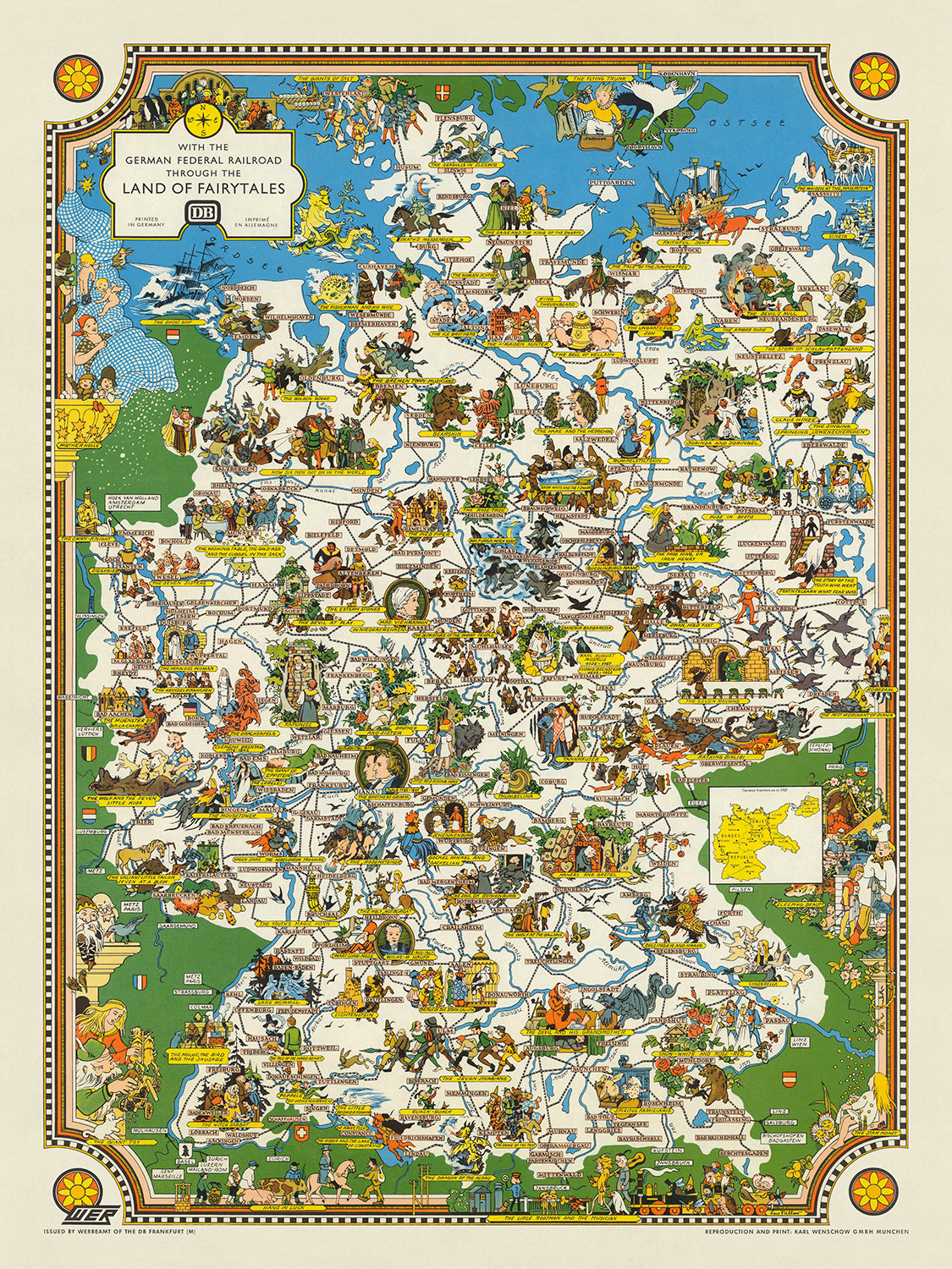
Entra nel mondo incantevole del folklore tedesco con questa mappa meticolosamente realizzata, "Con le Ferrovie Federali Tedesche attraverso il Paese delle Fiabe." Creata da Leo Faller e pubblicata dalla Deutsche Bundesbahn intorno al 1960, questa mappa illustrata offre un viaggio delizioso attraverso il ricco arazzo del patrimonio delle fiabe tedesche. La mappa illustra magnificamente i racconti senza tempo raccolti dai fratelli Grimm, le cui opere hanno affascinato generazioni. Dalle avventure di Cappuccetto Rosso alle astuzie di Puss in Boots, ogni storia prende vita in modo vivido, rendendo questa mappa un tesoro di storia culturale.
La mappa non è solo un piacere visivo ma anche una rappresentazione geografica dettagliata della Germania. Le città e i paesi sono etichettati con precisione, mentre le autostrade e i fiumi si snodano attraverso il paese, fornendo una vista completa del paesaggio. I comuni sono contrassegnati con lettere maiuscole in riquadri rosa, e le fiabe sono evidenziate con banner gialli, rendendo facile la navigazione attraverso questa terra fantastica. L'inclusione di una mappa in dettaglio intitolata "Frontere tedesche nel 1937" aggiunge uno strato di contesto storico, riflettendo il panorama politico dell'epoca.
Ciò che distingue questa mappa è il suo significato storico. Le etichette "Zona Sovietica" e "Repubblica Democratica" la datano fermamente all'era della Guerra Fredda, offrendo uno sguardo su una Germania divisa. Questa giustapposizione tra la fantasia delle fiabe e la cruda realtà della divisione politica rende la mappa un affascinante reperto del suo tempo. Serve da promemoria di come il patrimonio culturale possa resistere e prosperare anche in mezzo a turbolenze politiche. Le illustrazioni dettagliate della mappa e i riferimenti storici la rendono una risorsa inestimabile per chiunque sia interessato alla storia culturale e politica della Germania.
Lo stile artistico della mappa è un altro aspetto che la rende davvero unica. I colori vivaci e le illustrazioni intricate catturano l'essenza di ogni fiaba, trasportando lo spettatore in un mondo di magia e meraviglia. Dai castelli imponenti alle foreste dense, ogni elemento è meticolosamente dettagliato, riflettendo la ricca immaginazione dei fratelli Grimm e l'abilità del cartografo. I bordi decorativi e i motivi migliorano ulteriormente il suo fascino visivo, rendendola non solo una mappa ma un'opera d'arte.
Avere questa mappa è come tenere un pezzo di storia tra le mani. Offre una miscela unica di intuizioni culturali, geografiche e storiche, rendendola un'aggiunta perfetta a qualsiasi collezione. Che tu sia un appassionato di storia, un amante delle fiabe o semplicemente qualcuno che apprezza l'arte raffinata, questa mappa sicuramente catturerà la tua immaginazione. Essa rappresenta una testimonianza del potere duraturo delle storie e del complesso arazzo della storia, rendendola un'acquisizione davvero lussuosa e significativa.
Luoghi su questa mappa
- Berlino
- Amburgo
- Monaco
- Francoforte
- Colonia
- Stoccarda
- Düsseldorf
- Leipzig
- Dresda
- Bremen
- Hanover
- Nuremberg
- Essen
- Dortmund
- Bonn
- Mannheim
- Karlsruhe
- Wiesbaden
- Münster
- Augsburg
Caratteristiche e Monumenti Notabili
- Illustrazioni di fiabe come Cappuccetto Rosso, Puss in Boots, Hansel e Gretel, Cenerentola, Biancaneve e il Pifferaio Magico.
- Città e paesi etichettati in tutta la Germania.
- Autostrade e fiumi rappresentati in tutto il paese.
- Striscioni gialli che segnano le posizioni di varie fiabe.
- Una mappa in miniatura che mostra "i confini tedeschi nel 1937".
- Etichette che indicano "Zona Sovietica" e "Repubblica Democratica".
- Illustrazioni dettagliate di personaggi e scene delle fiabe.
- Bordi ed elementi decorativi attorno alla mappa.
- Monumenti storici e città significative.
- Caratteristiche geografiche dettagliate come montagne, foreste e fiumi.
- Il titolo e la legenda della mappa nell'angolo in alto a sinistra.
- Il logo della Deutsche Bundesbahn (Ferrovie Federali Tedesche).
- Rappresentazioni pittoriche di diverse regioni in Germania.
- Rosone decorativo della bussola.
- Illustrazioni di famosi castelli e monumenti tedeschi.
- Il bordo decorativo della mappa con motivi delle fiabe.
- Etichette che indicano regioni e città storiche.
- Illustrazioni di costumi tradizionali tedeschi e folklore.
- Rappresentazione dettagliata del paesaggio tedesco.
- Il design vibrante e colorato della mappa.
- Il contesto storico fornito dalle etichette e illustrazioni della mappa.
- Il significato educativo e culturale della mappa.
- Illustrazioni di famosi personaggi letterari tedeschi.
- Rappresentazione dettagliata di personaggi e scene delle fiabe.
- Riferimenti storici e culturali della mappa.
- Lo stile artistico e illustrativo della mappa.
- Il design dettagliato e informativo della mappa.
- Il focus della mappa sul patrimonio culturale tedesco.
Contesto storico e di design
- Creato da Leo Faller e pubblicato dalla Deutsche Bundesbahn intorno al 1960.
- Mettere in evidenza le fiabe dei rinomati editori, Jakob e Wilhelm Grimm, noti anche come i fratelli Grimm.
- I fratelli Grimm pubblicarono diverse edizioni delle loro raccolte di fiabe, iniziando nel 1812 con 86 storie, e nella settima edizione nel 1857, avevano raccolto 211 diverse fiabe.
- La mappa fornisce una prospettiva culturale e storica sul patrimonio delle fiabe tedesche.
- Riflette il contesto politico della Guerra Fredda, con etichette come "Zona Sovietica" e "Repubblica Democratica" che indicano la divisione della Germania durante quel periodo.
- La mappa è altamente dettagliata e pittorica, con illustrazioni che rappresentano varie fiabe.
- Città e paesi sono etichettati con lettere in blocco all'interno di riquadri rosa.
- Striscioni gialli segnano le posizioni associate a diverse fiabe.
- Una mappa in miniatura intitolata "i confini tedeschi nel 1937" aggiunge uno strato di contesto storico.
- Le illustrazioni dettagliate e i riferimenti storici della mappa la rendono una risorsa preziosa per chiunque sia interessato alla storia culturale e politica della Germania.
- I colori vivaci e le illustrazioni intricate catturano l'essenza di ogni fiaba.
- I bordi e i motivi decorativi migliorano ulteriormente il suo fascino visivo, rendendola non solo una mappa ma un'opera d'arte.
Si prega di controllare attentamente le immagini per assicurarsi che una specifica città o luogo sia mostrato su questa mappa. Puoi anche contattarci e chiedere di controllare la mappa per te.
Questa mappa appare fantastica in tutte le dimensioni, ma consiglio sempre di optare per una dimensione più grande se hai spazio. In questo modo puoi facilmente distinguere tutti i dettagli.
Questa mappa appare straordinaria in dimensioni fino a 100in (250cm). Se stai cercando una mappa più grande, per favore contattaci.
Si prega di notare: le etichette su questa mappa sono difficili da leggere se si ordina una mappa che è di 16 pollici (40 cm) o più piccola. La mappa è comunque molto attraente, ma se desideri leggere facilmente la mappa, ti preghiamo di acquistare una dimensione più grande.
Il modello nelle immagini dell'elenco tiene in mano la versione 18x24 pollici (45x60 cm) di questa mappa.
La quinta immagine dell'elenco mostra un esempio del mio servizio di personalizzazione delle mappe.
Se stai cercando qualcosa di leggermente diverso, dai un'occhiata alla mia collezione delle migliori mappe antiche per vedere se qualcosa attira la tua attenzione.
Per favore contattami per verificare se una certa posizione, punto di riferimento o caratteristica è mostrata su questa mappa.
Questa sarebbe una meravigliosa idea regalo per un compleanno, Natale, Festa del Papà, festa di addio al lavoro, anniversario o inaugurazione della casa per qualcuno delle aree coperte da questa mappa.
Questa mappa è disponibile come stampa giclée su carta opaca archiviata senza acidi, oppure puoi acquistarla incorniciata. La cornice è una semplice cornice nera che si adatta alla maggior parte degli estetismi. Ti preghiamo di contattarmi se desideri un colore o un materiale diverso per la cornice. Le mie cornici sono rivestite con un acrilico (perspex/acrylite) super chiaro di grado museale, che è significativamente meno riflettente del vetro, più sicuro e arriverà sempre in condizioni perfette.
This map is also available as a float framed canvas, sometimes known as a shadow gap framed canvas or canvas floater. The map is printed on artist's cotton canvas and then stretched over a handmade box frame. We then "float" the canvas inside a wooden frame, which is available in a range of colours (black, dark brown, oak, antique gold and white). This is a wonderful way to present a map without glazing in front. See some examples of float framed canvas maps and explore the differences between my different finishes.
For something truly unique, this map is also available in "Unique 3D", our trademarked process that dramatically transforms the map so that it has a wonderful sense of depth. We combine the original map with detailed topography and elevation data, so that mountains and the terrain really "pop". For more info and examples of 3D maps, check my Unique 3D page.
For most orders, delivery time is about 3 working days. Personalised and customised products take longer, as I have to do the personalisation and send it to you for approval, which usually takes 1 or 2 days.
Please note that very large framed orders usually take longer to make and deliver.
If you need your order to arrive by a certain date, please contact me before you order so that we can find the best way of making sure you get your order in time.
I print and frame maps and artwork in 23 countries around the world. This means your order will be made locally, which cuts down on delivery time and ensures that it won't be damaged during delivery. You'll never pay customs or import duty, and we'll put less CO2 into the air.
All of my maps and art prints are well packaged and sent in a rugged tube if unframed, or surrounded by foam if framed.
I try to send out all orders within 1 or 2 days of receiving your order, though some products (like face masks, mugs and tote bags) can take longer to make.
If you select Express Delivery at checkout your order we will prioritise your order and send it out by 1-day courier (Fedex, DHL, UPS, Parcelforce).
Next Day delivery is also available in some countries (US, UK, Singapore, UAE) but please try to order early in the day so that we can get it sent out on time.
My standard frame is a gallery style black ash hardwood frame. It is simple and quite modern looking. My standard frame is around 20mm (0.8in) wide.
I use super-clear acrylic (perspex/acrylite) for the frame glass. It's lighter and safer than glass - and it looks better, as the reflectivity is lower.
Six standard frame colours are available for free (black, dark brown, dark grey, oak, white and antique gold). Custom framing and mounting/matting is available if you're looking for something else.
Most maps, art and illustrations are also available as a framed canvas. We use matte (not shiny) cotton canvas, stretch it over a sustainably sourced box wood frame, and then 'float' the piece within a wood frame. The end result is quite beautiful, and there's no glazing to get in the way.
All frames are provided "ready to hang", with either a string or brackets on the back. Very large frames will have heavy duty hanging plates and/or a mounting baton. If you have any questions, please get in touch.
See some examples of my framed maps and framed canvas maps.
Alternatively, I can also supply old maps and artwork on canvas, foam board, cotton rag and other materials.
If you want to frame your map or artwork yourself, please read my size guide first.
Alcune delle mie vecchie mappe sono ora disponibili come tele incorniciate. Per favore contattami se desideri ordinare una dimensione che non è disponibile nel mio negozio.
Le vecchie mappe su tela sono un'alternativa interessante alle mappe incorniciate in modo convenzionale. A seconda del tuo gusto personale e dell'arredamento della stanza, le mappe su tela possono "risaltare" un po' di più rispetto a una mappa incorniciata.
My maps are extremely high quality reproductions of original maps.
I source original, rare maps from libraries, auction houses and private collections around the world, restore them at my London workshop, and then use specialist giclée inks and printers to create beautiful maps that look even better than the original.
My maps are printed on acid-free archival matte (not glossy) paper that feels very high quality and almost like card. In technical terms the paper weight/thickness is 10mil/200gsm. It's perfect for framing.
I print with Epson ultrachrome giclée UV fade resistant pigment inks - some of the best inks you can find.
I can also make maps on canvas, cotton rag and other exotic materials.
Learn more about The Unique Maps Co.
Map personalisation
If you're looking for the perfect anniversary or housewarming gift, I can personalise your map to make it truly unique. For example, I can add a short message, or highlight an important location, or add your family's coat of arms.
The options are almost infinite. Please see my map personalisation page for some wonderful examples of what's possible.
To order a personalised map, select "personalise your map" before adding it to your basket.
Get in touch if you're looking for more complex customisations and personalisations.
Map ageing
I have been asked hundreds of times over the years by customers if they could buy a map that looks even older.
Well, now you can, by selecting Aged before you add a map to your basket.
All the product photos you see on this page show the map in its Original form. This is what the map looks like today.
If you select Aged, I will age your map by hand, using a special and unique process developed through years of studying old maps, talking to researchers to understand the chemistry of aging paper, and of course... lots of practice!
If you're unsure, stick to the Original colour of the map. If you want something a bit darker and older looking, go for Aged.
Se non sei soddisfatto del tuo ordine per qualsiasi motivo, contattami per un rimborso senza problemi. Si prega di consultare la nostra politica di reso e rimborso per ulteriori informazioni.
Sono molto sicuro che ti piacerà la tua mappa restaurata o la stampa d'arte. Lo faccio dal 1984. Sono un venditore Etsy a 5 stelle. Ho venduto decine di migliaia di mappe e stampe d'arte e ho oltre 5.000 recensioni reali a 5 stelle.
Utilizzo un processo unico per restaurare mappe e opere d'arte che richiede molto tempo e lavoro. Trovare le mappe e le illustrazioni originali può richiedere mesi. Utilizzo tecnologia all'avanguardia e incredibilmente costosa per scannerizzare e restaurarle. Di conseguenza, garantisco che le mie mappe e stampe d'arte siano superiori alle altre - ecco perché posso offrire un rimborso senza problemi.
Quasi tutte le mie mappe e stampe d'arte sembrano fantastiche a grandi dimensioni (200 cm, 6,5 piedi+) e posso anche incorniciarle e consegnarle a te, tramite un corriere speciale per oggetti di grandi dimensioni. Contattami per discutere delle tue esigenze specifiche.
Or try searching for something!


