


Mappa antica delle stazioni di salvataggio delle Isole Britanniche, 1935: Carta storica della RNLI
Compra 2, Ricevi 1 Gratuito
Se aggiungi 2 articoli al tuo carrello, puoi aggiungere un terzo prodotto gratuitamente.
Questo vale per tutte le mappe e opere d'arte, comprese le opere personalizzate e su misura. Puoi ordinare 3 dello stesso articolo, o 3 articoli diversi.
Questo equivale a uno sconto del 33%, che sarà il maggiore sconto disponibile nel mio negozio quest'anno.
Ti prego di approfittare dell'offerta e di coprire le tue pareti con bellissime mappe e opere d'arte!
Contattami se hai domande.
- All taxes and duties included
- Handmade & dispatched in 1-2 days
-
Complimentary gifting & design advice
ⓘ
Complimentary gifting & design advice
Available almost 24/7 on WhatsApp and email — we usually reply within minutes. We can help you:
- Choose a perfectly personalised gift
- Send a digital gift preview to the recipient
- Pick the ideal size for your wall
- Select the right finish and frame
Quick, friendly advice so you can order with confidence.
For last minute gifts, consider buying a digital gift card. We have over 5,000 maps and art prints to choose from.
-
90-day returns & 5-year guarantee
ⓘ
90 giorni per restituire e ricevere un rimborso
I prodotti possono essere restituiti entro 90 giorni per un rimborso completo, o cambio con un altro prodotto.
Per articoli personalizzati e su misura, potremmo offrirti un credito in negozio o una carta regalo non scadente, poiché non possiamo rivendere ordini personalizzati.
Se hai domande, contattaci. Per ulteriori informazioni, consulta la nostra politica di restituzione e cambio.

This is a museum-grade archival print from the original 1935 map — restored in our workshop and made to order on 220gsm archival matte paper or 400gsm artist's cotton canvas with pigment inks.
Professional framing & free personalisation available
1. Select your size
Click here to order a custom size.
2. Frame & personalise your map
Make your map unique with framing, hand-drawn customisation, vintage ageing, pop art text, unique 3D styling and more.


Gift message & custom finish

If you want to add a gift message, or a finish (jigsaw, aluminium board, etc.) that is not available here, please request it in the "order note" when you check out.
Every order is custom made, so if you need the size adjusted slightly, or printed on an unusual material, just let us know. We've done thousands of custom orders over the years, so there's (almost) nothing we can't manage.
You can also contact us before you order, if you prefer!

- Handmade locally. No import duty or tax
- FREE worldwide delivery
- 90-day returns & 5-year product guarantee
- Questions? WhatsApp me any time
Own a piece of history
7,000+ 5 star reviews


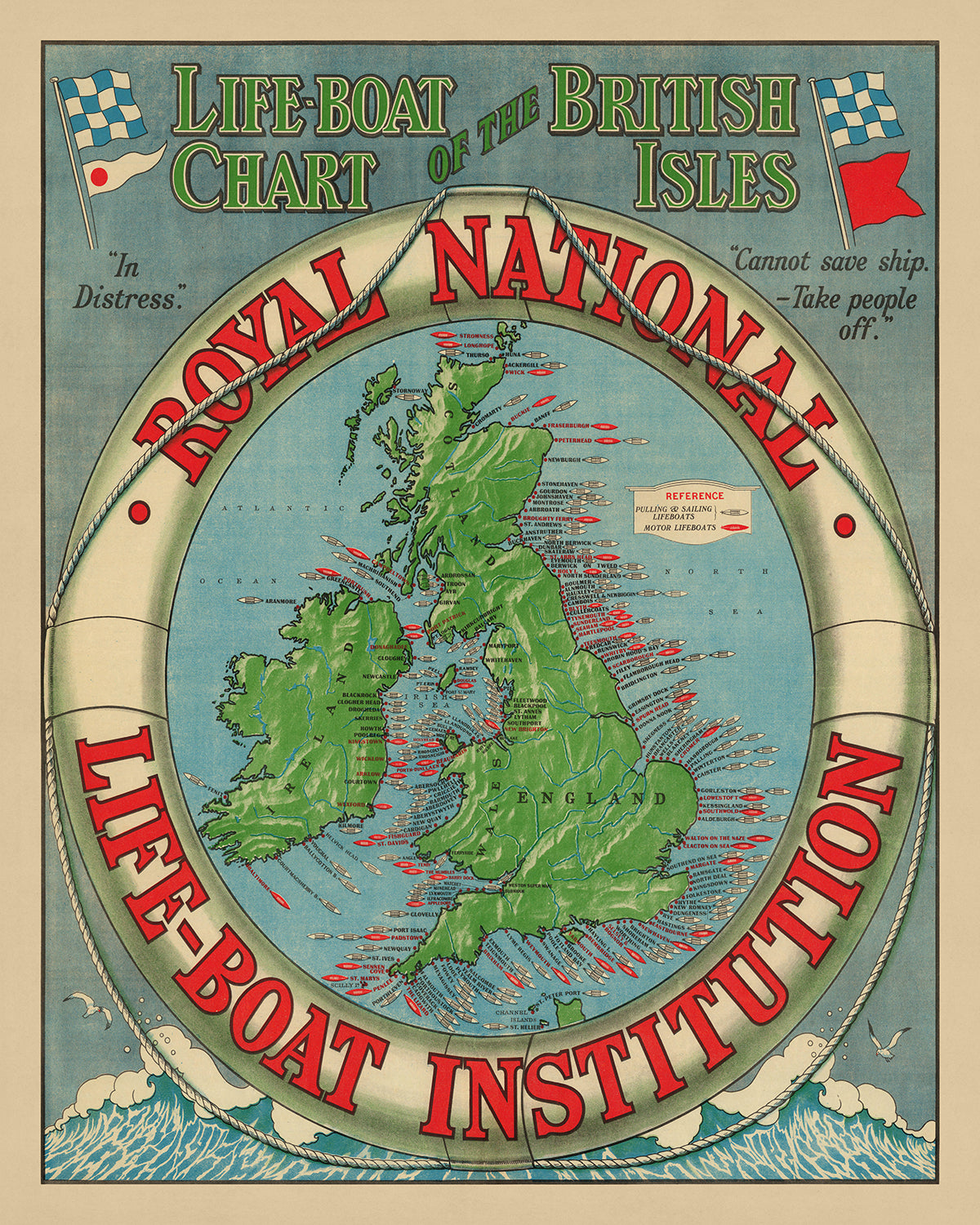
Imbarcati in un viaggio marittimo attraverso il tempo con la "Mappa delle scialuppe delle Isole Britanniche," una mappa tematica e pittorica che serve da testimonianza all'eredità duratura della Royal National Lifeboat Institution (RNLI). Creata nel 1935, questa mappa non è semplicemente uno strumento di navigazione, ma un artefatto storico che illumina il ruolo vitale delle stazioni di salvataggio nel proteggere i marinai e le comunità costiere del Regno Unito, dell'Irlanda, delle Isole del Canale e dell'Isola di Man. La RNLI, fondata nel 1824, è stata un faro di speranza, salvando oltre 140.000 vite con la sua flotta di scialuppe. Questa mappa, con la sua dettagliata rappresentazione delle stazioni di salvataggio, è un tributo al coraggio e alla dedizione di coloro che hanno affrontato le acque insidiose per salvare gli altri.
Il design della mappa è sia semplice che evocativo, con uno sfondo blu che rispecchia l'immensa distesa del mare, mentre il testo rosso e nero evidenzia le posizioni delle stazioni di salvataggio con chiarezza e precisione. Ogni stazione è contrassegnata da un'icona di piccola barca, una rappresentazione simbolica di speranza e salvataggio di fronte al pericolo. Il bordo decorativo, adornato con una corda e un salvagente, incornicia la mappa, aggiungendo un tocco di eleganza e sottolineando il focus tematico della mappa sulla sicurezza marittima e le operazioni di salvataggio.
È importante notare che la "Mappa delle scialuppe delle Isole Britanniche" è più di una rappresentazione geografica; è un documento storico che cattura un momento nel tempo in cui le operazioni di salvataggio della RNLI erano cruciali per la navigazione marittima e la sicurezza. La tabella di riferimento e le note, inclusi messaggi toccanti come "In difficoltà" e "Non posso salvare la nave - portare via le persone," offrono un'idea delle sfide affrontate dai marinai e degli sforzi eroici degli equipaggi delle scialuppe per superarle. Questa mappa offre una prospettiva unica sugli aspetti tecnologici e operativi delle stazioni di salvataggio a metà del XX secolo.
Il significato storico della mappa è ulteriormente arricchito dalla sua copertura di una vasta gamma di località, dai porti affollati di Dover e Plymouth alla bellezza serena delle Isole Scilly e The Lizard. Serve da guida alla geografia costiera delle Isole Britanniche, evidenziando le principali città, paesi e caratteristiche geografiche, così come il posizionamento strategico delle stazioni di salvataggio lungo la costa. Questa ampia copertura sottolinea l'approccio completo della RNLI alla sicurezza marittima, assicurando che nessun angolo delle Isole Britanniche fosse lasciato senza protezione.
In conclusione, la "Mappa delle scialuppe delle Isole Britanniche" non è solo una mappa; è un artefatto storico che offre una finestra sul passato, mostrando lo spirito duraturo della RNLI e la sua eredità salvataggio. Invita gli spettatori a riflettere sull'importanza della sicurezza marittima, i progressi nella tecnologia di salvataggio e gli atti disinteressati di coraggio che hanno caratterizzato la missione della RNLI sin dalla sua nascita. Questa mappa è un must per collezionisti, storici e chiunque sia affascinato dal ricco patrimonio marittimo delle Isole Britanniche.
Luoghi su questa mappa
- Irlanda
- Inghilterra
- Scozia
- Galles
- Isola di Man
- Isole del Canale
- Mar del Nord
- Oceano Atlantico
- Mar d'Irlanda
- Mar Celtico
- Canale di San Giorgio
- Canale del Nord
- Moray Firth
- Firth of Forth
- Firth of Clyde
- Solway Firth
- Cardigan Bay
- Canale di Bristol
- The Wash
- Estuario dell'Humber
- Estuario del Tamigi
- Canale Inglese
- Stretto di Dover
- Dover
- Folkestone
- Hastings
- Eastbourne
- Brighton
- Worthing
- Bognor Regis
- Selsey Bill
- Portsmouth
- Southampton
- Bournemouth
- Poole
- Swanage
- Weymouth
- Exmouth
- Teignmouth
- Brixham
- Dartmouth
- Plymouth
- Looe
- Fowey
- Mevagissey
- Falmouth
- Port Isaac
- Padstow
- Newquay
- St. Ives
- Sennen Cove
- St. Mary's
- Isole Scilly
- Penlee
- Porthleven
- Porthoustock
- Coverack
- Cadgwith
- The Lizard
- Baltimore
Caratteristiche e monumenti notevoli
- La mappa è un grafico delle Isole Britanniche, che mostra la posizione delle stazioni di salvataggio lungo la costa.
- La mappa è circondata da un bordo decorativo che presenta una corda e un salvagente.
- Il titolo della mappa è "Carta dei Salvataggi delle Isole Britanniche" ed è posizionato in cima alla mappa.
- La mappa è orientata con il nord in alto.
- La mappa mostra la costa delle Isole Britanniche in dettaglio, con città principali, paesi e caratteristiche geografiche etichettate.
- La mappa mostra anche la posizione delle stazioni di salvataggio lungo la costa, con ogni stazione rappresentata da una piccola icona di barca.
- La mappa include una tabella di riferimento nell'angolo in basso a destra, che fornisce informazioni sui diversi tipi di scialuppa di salvataggio e le loro posizioni.
- La mappa include anche una nota che recita: "In difficoltà - Non posso salvare la nave - Portare via le persone."
Contesto storico e di design
- La mappa è stata creata nel 1935.
- È una mappa tematica, focalizzata sulla posizione delle stazioni di salvataggio.
- La mappa fornisce una preziosa istantanea della posizione delle stazioni di salvataggio lungo le coste delle Isole Britanniche nel 1935.
- La Royal National Lifeboat Institution (RNLI) è la più grande organizzazione benefica che salva vite in mare lungo le coste del Regno Unito, Irlanda, Isole del Canale e Isola di Man, così come su alcune vie navigabili interne.
- La RNLI è stata fondata nel 1824 ed è una delle più antiche organizzazioni di salvataggio al mondo.
- La RNLI gestisce una flotta di oltre 200 scialuppe di salvataggio e ha salvato oltre 140.000 vite dalla sua fondazione.
- Il design della mappa è relativamente semplice, con uno sfondo blu e testo rosso e nero.
Si prega di controllare le immagini per assicurarsi che una specifica città o luogo sia mostrato su questa mappa. Puoi anche contattarci e chiedere di controllare la mappa per te.
Questa mappa appare fantastica in ogni dimensione, ma consiglio sempre di optare per una dimensione più grande se hai spazio. In questo modo puoi facilmente distinguere tutti i dettagli.
Questa mappa appare incredibile in dimensioni fino a 100in (250cm). Se stai cercando una mappa più grande, per favore contattaci.
Il modello nelle immagini dell'elenco tiene in mano la versione 16x20in (40x50cm) di questa mappa.
La quinta immagine dell'elenco mostra un esempio del mio servizio di personalizzazione della mappa.
Se stai cercando qualcosa di leggermente diverso, dai un'occhiata alla mia collezione delle migliori mappe antiche per vedere se qualcosa attira la tua attenzione.
Si prega di contattarmi per verificare se una certa posizione, monumento o caratteristica è mostrata su questa mappa.
Questo sarebbe un meraviglioso regalo per un compleanno, Natale, Festa del Papà, partenza dal lavoro, anniversario o inaugurazione per qualcuno delle aree coperte da questa mappa.
Questa mappa è disponibile come stampa giclée su carta opaca archiviabile senza acidi, oppure puoi acquistarla incorniciata. La cornice è una semplice cornice nera che si adatta alla maggior parte degli stili estetici. Ti preghiamo di contattarci se desideri un colore o un materiale diverso per la cornice. Le mie cornici sono dotate di vetro acrilico super chiaro di grado museale (perspex/acrylite), che è significativamente meno riflettente del vetro, più sicuro e arriverà sempre in perfette condizioni.
This map is also available as a float framed canvas, sometimes known as a shadow gap framed canvas or canvas floater. The map is printed on artist's cotton canvas and then stretched over a handmade box frame. We then "float" the canvas inside a wooden frame, which is available in a range of colours (black, dark brown, oak, antique gold and white). This is a wonderful way to present a map without glazing in front. See some examples of float framed canvas maps and explore the differences between my different finishes.
For something truly unique, this map is also available in "Unique 3D", our trademarked process that dramatically transforms the map so that it has a wonderful sense of depth. We combine the original map with detailed topography and elevation data, so that mountains and the terrain really "pop". For more info and examples of 3D maps, check my Unique 3D page.
For most orders, delivery time is about 3 working days. Personalised and customised products take longer, as I have to do the personalisation and send it to you for approval, which usually takes 1 or 2 days.
Please note that very large framed orders usually take longer to make and deliver.
If you need your order to arrive by a certain date, please contact me before you order so that we can find the best way of making sure you get your order in time.
I print and frame maps and artwork in 23 countries around the world. This means your order will be made locally, which cuts down on delivery time and ensures that it won't be damaged during delivery. You'll never pay customs or import duty, and we'll put less CO2 into the air.
All of my maps and art prints are well packaged and sent in a rugged tube if unframed, or surrounded by foam if framed.
I try to send out all orders within 1 or 2 days of receiving your order, though some products (like face masks, mugs and tote bags) can take longer to make.
If you select Express Delivery at checkout your order we will prioritise your order and send it out by 1-day courier (Fedex, DHL, UPS, Parcelforce).
Next Day delivery is also available in some countries (US, UK, Singapore, UAE) but please try to order early in the day so that we can get it sent out on time.
My standard frame is a gallery style black ash hardwood frame. It is simple and quite modern looking. My standard frame is around 20mm (0.8in) wide.
I use super-clear acrylic (perspex/acrylite) for the frame glass. It's lighter and safer than glass - and it looks better, as the reflectivity is lower.
Six standard frame colours are available for free (black, dark brown, dark grey, oak, white and antique gold). Custom framing and mounting/matting is available if you're looking for something else.
Most maps, art and illustrations are also available as a framed canvas. We use matte (not shiny) cotton canvas, stretch it over a sustainably sourced box wood frame, and then 'float' the piece within a wood frame. The end result is quite beautiful, and there's no glazing to get in the way.
All frames are provided "ready to hang", with either a string or brackets on the back. Very large frames will have heavy duty hanging plates and/or a mounting baton. If you have any questions, please get in touch.
See some examples of my framed maps and framed canvas maps.
Alternatively, I can also supply old maps and artwork on canvas, foam board, cotton rag and other materials.
If you want to frame your map or artwork yourself, please read my size guide first.
Alcune delle mie vecchie mappe sono ora disponibili come tele incorniciate. Per favore contattami se desideri ordinare una dimensione che non è disponibile nel mio negozio.
Le vecchie mappe su tela sono un'alternativa interessante alle mappe incorniciate in modo convenzionale. A seconda del tuo gusto personale e dell'arredamento della stanza, le mappe su tela possono "risaltare" un po' di più rispetto a una mappa incorniciata.
My maps are extremely high quality reproductions of original maps.
I source original, rare maps from libraries, auction houses and private collections around the world, restore them at my London workshop, and then use specialist giclée inks and printers to create beautiful maps that look even better than the original.
My maps are printed on acid-free archival matte (not glossy) paper that feels very high quality and almost like card. In technical terms the paper weight/thickness is 10mil/200gsm. It's perfect for framing.
I print with Epson ultrachrome giclée UV fade resistant pigment inks - some of the best inks you can find.
I can also make maps on canvas, cotton rag and other exotic materials.
Learn more about The Unique Maps Co.
Map personalisation
If you're looking for the perfect anniversary or housewarming gift, I can personalise your map to make it truly unique. For example, I can add a short message, or highlight an important location, or add your family's coat of arms.
The options are almost infinite. Please see my map personalisation page for some wonderful examples of what's possible.
To order a personalised map, select "personalise your map" before adding it to your basket.
Get in touch if you're looking for more complex customisations and personalisations.
Map ageing
I have been asked hundreds of times over the years by customers if they could buy a map that looks even older.
Well, now you can, by selecting Aged before you add a map to your basket.
All the product photos you see on this page show the map in its Original form. This is what the map looks like today.
If you select Aged, I will age your map by hand, using a special and unique process developed through years of studying old maps, talking to researchers to understand the chemistry of aging paper, and of course... lots of practice!
If you're unsure, stick to the Original colour of the map. If you want something a bit darker and older looking, go for Aged.
Se non sei soddisfatto del tuo ordine per qualsiasi motivo, contattami per un rimborso senza problemi. Si prega di consultare la nostra politica di reso e rimborso per ulteriori informazioni.
Sono molto sicuro che ti piacerà la tua mappa restaurata o la stampa d'arte. Lo faccio dal 1984. Sono un venditore Etsy a 5 stelle. Ho venduto decine di migliaia di mappe e stampe d'arte e ho oltre 5.000 recensioni reali a 5 stelle.
Utilizzo un processo unico per restaurare mappe e opere d'arte che richiede molto tempo e lavoro. Trovare le mappe e le illustrazioni originali può richiedere mesi. Utilizzo tecnologia all'avanguardia e incredibilmente costosa per scannerizzare e restaurarle. Di conseguenza, garantisco che le mie mappe e stampe d'arte siano superiori alle altre - ecco perché posso offrire un rimborso senza problemi.
Quasi tutte le mie mappe e stampe d'arte sembrano fantastiche a grandi dimensioni (200 cm, 6,5 piedi+) e posso anche incorniciarle e consegnarle a te, tramite un corriere speciale per oggetti di grandi dimensioni. Contattami per discutere delle tue esigenze specifiche.
Or try searching for something!


