

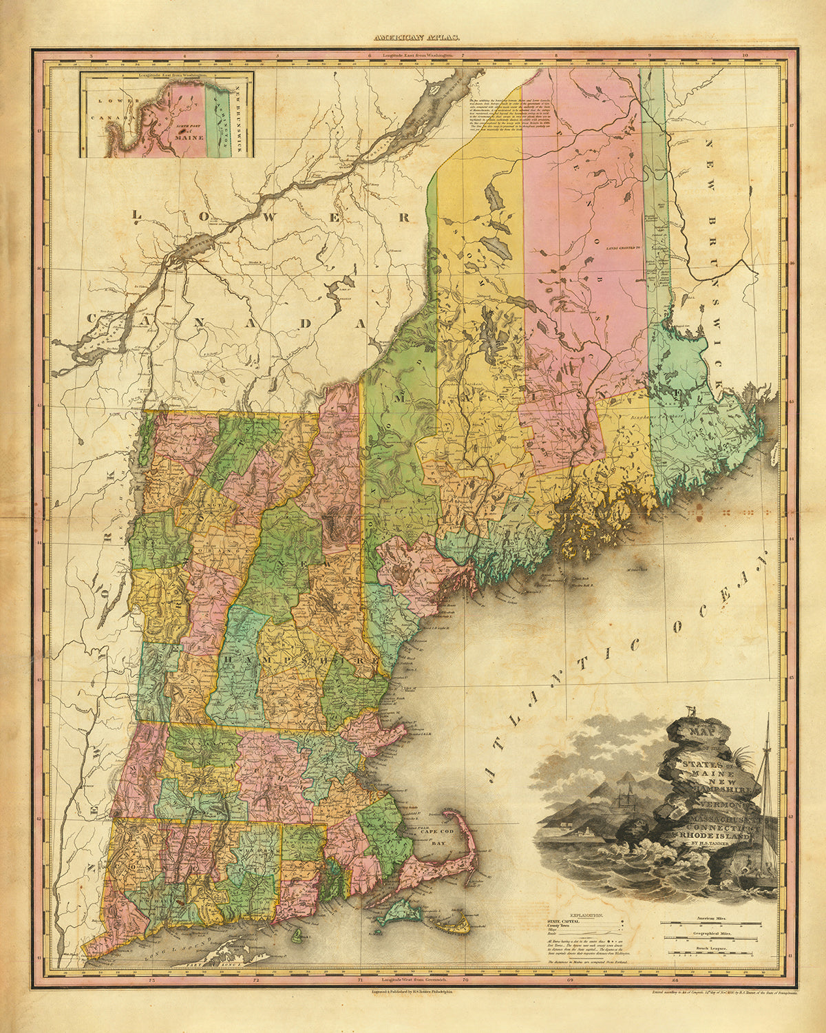


Antica mappa del New England di H. S. Tanner, 1820: Boston, Providence, Hartford, Portland, Worcester
Compra 2, Ricevi 1 Gratuito
Se aggiungi 2 articoli al tuo carrello, puoi aggiungere un terzo prodotto gratuitamente.
Questo vale per tutte le mappe e opere d'arte, comprese le opere personalizzate e su misura. Puoi ordinare 3 dello stesso articolo, o 3 articoli diversi.
Questo equivale a uno sconto del 33%, che sarà il maggiore sconto disponibile nel mio negozio quest'anno.
Ti prego di approfittare dell'offerta e di coprire le tue pareti con bellissime mappe e opere d'arte!
Contattami se hai domande.
- All taxes and duties included
- Handmade & dispatched in 1-2 days
-
Complimentary gifting & design advice
ⓘ
Complimentary gifting & design advice
Available almost 24/7 on WhatsApp and email — we usually reply within minutes. We can help you:
- Choose a perfectly personalised gift
- Send a digital gift preview to the recipient
- Pick the ideal size for your wall
- Select the right finish and frame
Quick, friendly advice so you can order with confidence.
For last minute gifts, consider buying a digital gift card. We have over 5,000 maps and art prints to choose from.
-
90-day returns & 5-year guarantee
ⓘ
90 giorni per restituire e ricevere un rimborso
I prodotti possono essere restituiti entro 90 giorni per un rimborso completo, o cambio con un altro prodotto.
Per articoli personalizzati e su misura, potremmo offrirti un credito in negozio o una carta regalo non scadente, poiché non possiamo rivendere ordini personalizzati.
Se hai domande, contattaci. Per ulteriori informazioni, consulta la nostra politica di restituzione e cambio.

This is a museum-grade archival print from the original 1820 map — restored in our workshop and made to order on 220gsm archival matte paper or 400gsm artist's cotton canvas with pigment inks.
Professional framing & free personalisation available
1. Choose a size
2. Frame & personalise your map
Make your map unique with framing, hand-drawn customisation, vintage ageing, pop art text, unique 3D styling and more.


Gift message & custom finish

If you want to add a gift message, or a finish (jigsaw, aluminium board, etc.) that is not available here, please request it in the "order note" when you check out.
Every order is custom made, so if you need the size adjusted slightly, or printed on an unusual material, just let us know. We've done thousands of custom orders over the years, so there's (almost) nothing we can't manage.
You can also contact us before you order, if you prefer!

- Handmade locally. No import duty or tax
- FREE worldwide delivery
- 90-day returns & 5-year product guarantee
- Questions? WhatsApp me any time
Own a piece of history
7,000+ 5 star reviews


Fai un passo indietro nel tempo con questa squisita riproduzione della "Vecchia Mappa del New England" del rinomato cartografo H. S. Tanner. Pubblicata nel 1820, questa mappa meticolosamente dettagliata cattura i confini storici del Maine, del New Hampshire, del Vermont, del Massachusetts, del Connecticut e del Rhode Island. Immergiti nella ricca storia della regione mentre esplori gli insediamenti, le contee e le meraviglie naturali che hanno definito il New England durante quest'epoca cruciale. Che tu sia un appassionato storico, un entusiasta della cartografia o semplicemente un amante dell'arte delle mappe vintage, questo pezzo è un must-have per la tua collezione.
Caratteristiche Principali:
- Confini Storici Accurati: Approfondisci il passato e traccia i confini esatti del Maine, del New Hampshire, del Vermont, del Massachusetts, del Connecticut e del Rhode Island come esistevano nel 1820.
- Insediamenti Notabili: Scopri le città, i comuni e le colonie più popolose e storicamente significative fondate prima del 1820 nella regione.
- Monumenti e Meraviglie Naturali: Scopri i monumenti affascinanti, i fiumi, i canyon, i territori indiani e i fenomeni naturali che continuano ad attrarre turisti nel New England oggi.
- Eventi Storici: Ottieni informazioni sui principali eventi storici che hanno plasmato la regione tra il 1810 e il 1830, fornendo contesto al periodo dinamico catturato da questa mappa.
Insediamenti, Città e Contee Fondate Prima del 1820 nel New England:
Massachusetts:
- Boston (1630) - La capitale del Massachusetts, nota per il suo ruolo cruciale nella Guerra di Indipendenza Americana.
- Worcester (1674) - Un importante centro manifatturiero e culturale nella regione, noto per la sua importanza storica e la vivace scena artistica.
- Springfield (1636) - Il luogo di nascita del basket e un importante centro industriale e culturale nel Massachusetts.
- Lowell (1826) - Rinominata come la "Culla della Rivoluzione Industriale Americana" grazie ai suoi mulini tessili.
- Cambridge (1631) - Sede dell'Università di Harvard, una delle istituzioni educative più prestigiose al mondo.
Connecticut:
- Hartford (1635) - La capitale del Connecticut e una delle città più antiche degli Stati Uniti.
- New Haven (1638) - Fondata dai puritani, è diventata un centro di istruzione superiore ed è sede dell'Università di Yale.
- Bridgeport (1821) - Nota per la sua storia industriale, in particolare nella manifattura e nel commercio.
- Stamford (1640) - Conosciuta per il suo centro vivace e la scena artistica dinamica.
- Waterbury (1686) - Riconosciuta per la sua industria del ottone e il parco tematico storico Holy Land USA.
Rhode Island:
- Providence (1636) - La capitale del Rhode Island e un centro vivace per le arti, la cultura e l'istruzione.
- Warwick (1642) - Una delle città più antiche del Rhode Island, con bellissime aree costiere e siti storici.
- Cranston (1754) - Nota per la sua ricca storia, incluso l'historico Sprague Mansion e numerosi parchi.
- Pawtucket (1671) - Nota per la sua precoce industrializzazione e il luogo di nascita della Rivoluzione Industriale Americana.
- East Providence (1812) - Casa di parchi waterfront scenografici e una fiorente scena artistica e culinaria.
New Hampshire:
- Manchester (1751) - Una città vivace nota per il suo patrimonio industriale e il centro dinamico.
- Nashua (1746) - Situata sulle rive del fiume Merrimack, ha svolto un ruolo significativo nell'industria tessile.
- Concord (1727) - La capitale del New Hampshire, famosa per il suo ruolo nella guerra di indipendenza americana.
- Derry (1827) - Conosciuta come la "Città dello Spindle" a causa della sua precoce produzione tessile.
- Dover (1623) - Una delle più antiche colonie del New Hampshire, offre una ricca storia e panorami pittoreschi.
Maine:
- Portland (1632) - La città più grande del Maine, rinomata per la sua costa scenografica, il quartiere storico di Old Port e la vivace scena artistica.
- Lewiston (1795) - Una ex città di mulini, ha svolto un ruolo significativo nello sviluppo industriale del Maine.
- Bangor (1791) - Conosciuta come la "Città Regina dell'Est," ha servito come un importante porto di legname durante il XIX secolo.
- Auburn (1786) - Situata sul fiume Androscoggin, è diventata un importante centro di produzione.
- Brunswick (1628) - Sede del Bowdoin College e conosciuta per la sua ricca storia marittima.
Confini, Fiumi e Fenomeni Naturali Notabili:
- Fiume Connecticut: Maestoso corso d'acqua che scorre attraverso diversi stati del New England, offrendo panorami mozzafiato e opportunità ricreative.
- Monti Bianchi: Una catena montuosa mozzafiato nel New Hampshire, conosciuta per i suoi sentieri escursionistici, stazioni sciistiche e bellezze naturali.
- Monti Verdi: Una catena montuosa prominente nel Vermont, che offre panorami straordinari, sentieri escursionistici e aree sciistiche.
- Cape Cod: Una popolare meta turistica nel Massachusetts, conosciuta per le sue bellissime spiagge, i suoi affascinanti paesi e il suo patrimonio marittimo.
- Parco Nazionale di Acadia: Situato nel Maine, vanta paesaggi scenografici, picchi di granito e una costa frastagliata.
Eventi Storici nel New England (1810-1830):
- Guerra del 1812: Il New England ha avuto un coinvolgimento significativo in questo conflitto tra gli Stati Uniti e la Gran Bretagna.
- Convenzione di Hartford (1814): Un incontro dei Federalisti del New England durante la Guerra del 1812, che discuteva i reclami e la potenziale secessione.
- Il Decreto di Embargo (1807) e il Decreto di Non Interazione (1809): Gli stati del New England hanno affrontato difficoltà economiche a causa delle restrizioni commerciali durante questi atti.
- Rivoluzione Industriale: Il New England ha assistito alla rapida industrializzazione e crescita della produzione durante questo periodo.
Immergiti nel tessuto storico del New England con questa squisita riproduzione della "Vecchia Mappa del New England" di H. S. Tanner. Esplora gli insediamenti dettagliati, le contee, i punti di riferimento e le meraviglie naturali che hanno plasmato la regione nel 1820. Questa mappa serve sia come un affascinante pezzo di storia che come una straordinaria esposizione di arte cartografica, rendendola un'aggiunta preziosa a qualsiasi collezione o un regalo pensato per gli appassionati di storia, gli amanti delle mappe e chiunque sia affascinato dal ricco patrimonio del New England.
Si prega di controllare attentamente le immagini per assicurarsi che una specifica città o luogo sia mostrato su questa mappa. Puoi anche contattarci e chiedere di controllare la mappa per te.
Questa mappa appare fantastica in tutte le dimensioni: 12x16in (30.5x41cm), 16x20in (40.5x51cm), 18x24in (45.5x61cm), 24x30in (61x76cm), 32x40in (81.5x102cm), 40x50in (102x127cm), 48x60in (122x153cm) e 56x70in (142x178cm), ma appare ancora meglio quando stampata in grande.
Posso creare bellissime stampe di grandi dimensioni di questa mappa fino a 100in (254cm). Si prega di contattarci se stai cercando opzioni di incorniciatura più grandi, personalizzate o diverse.
Il modello nelle immagini dell'inserzione tiene la versione di questa mappa da 16x20 pollici (40,5x51 cm).
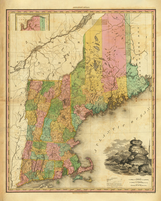
La quinta immagine dell'inserzione mostra un esempio del mio servizio di personalizzazione della mappa.
Si prega di notare che la mappa non incorniciata da 24x30 pollici (61x76 cm) ha bordi bianchi attorno alla mappa. Questi bordi possono aiutarti con l'incorniciatura, o se non ne hai bisogno, sono molto facili da tagliare con le forbici. Tutte le altre mappe, comprese quelle incorniciate, sembrano esattamente come le immagini dell'inserzione.
Se stai cercando qualcosa di leggermente diverso, dai un'occhiata alla mia collezione di mappe degli Stati Uniti e del Nord America.
Per favore contattami per verificare se una certa posizione, punto di riferimento o caratteristica è mostrata su questa mappa.
Questo sarebbe un regalo meraviglioso per un compleanno, Natale, Festa del Papà, un addio al lavoro, un anniversario o una festa di inaugurazione per qualcuno delle aree coperte da questa mappa.
Questa mappa è disponibile come stampa giclée su carta opaca archiviata senza acidi, oppure puoi acquistarla incorniciata. La cornice è una semplice cornice nera che si adatta alla maggior parte degli stili. Per favore, contattami se desideri un colore o un materiale della cornice diverso. Le mie cornici sono rivestite con acrilico di grado museale super chiaro (perspex/acrylite), che è significativamente meno riflettente del vetro, più sicuro e arriverà sempre in perfette condizioni.
This map is also available as a float framed canvas, sometimes known as a shadow gap framed canvas or canvas floater. The map is printed on artist's cotton canvas and then stretched over a handmade box frame. We then "float" the canvas inside a wooden frame, which is available in a range of colours (black, dark brown, oak, antique gold and white). This is a wonderful way to present a map without glazing in front. See some examples of float framed canvas maps and explore the differences between my different finishes.
For something truly unique, this map is also available in "Unique 3D", our trademarked process that dramatically transforms the map so that it has a wonderful sense of depth. We combine the original map with detailed topography and elevation data, so that mountains and the terrain really "pop". For more info and examples of 3D maps, check my Unique 3D page.
For most orders, delivery time is about 3 working days. Personalised and customised products take longer, as I have to do the personalisation and send it to you for approval, which usually takes 1 or 2 days.
Please note that very large framed orders usually take longer to make and deliver.
If you need your order to arrive by a certain date, please contact me before you order so that we can find the best way of making sure you get your order in time.
I print and frame maps and artwork in 23 countries around the world. This means your order will be made locally, which cuts down on delivery time and ensures that it won't be damaged during delivery. You'll never pay customs or import duty, and we'll put less CO2 into the air.
All of my maps and art prints are well packaged and sent in a rugged tube if unframed, or surrounded by foam if framed.
I try to send out all orders within 1 or 2 days of receiving your order, though some products (like face masks, mugs and tote bags) can take longer to make.
If you select Express Delivery at checkout your order we will prioritise your order and send it out by 1-day courier (Fedex, DHL, UPS, Parcelforce).
Next Day delivery is also available in some countries (US, UK, Singapore, UAE) but please try to order early in the day so that we can get it sent out on time.
My standard frame is a gallery style black ash hardwood frame. It is simple and quite modern looking. My standard frame is around 20mm (0.8in) wide.
I use super-clear acrylic (perspex/acrylite) for the frame glass. It's lighter and safer than glass - and it looks better, as the reflectivity is lower.
Six standard frame colours are available for free (black, dark brown, dark grey, oak, white and antique gold). Custom framing and mounting/matting is available if you're looking for something else.
Most maps, art and illustrations are also available as a framed canvas. We use matte (not shiny) cotton canvas, stretch it over a sustainably sourced box wood frame, and then 'float' the piece within a wood frame. The end result is quite beautiful, and there's no glazing to get in the way.
All frames are provided "ready to hang", with either a string or brackets on the back. Very large frames will have heavy duty hanging plates and/or a mounting baton. If you have any questions, please get in touch.
See some examples of my framed maps and framed canvas maps.
Alternatively, I can also supply old maps and artwork on canvas, foam board, cotton rag and other materials.
If you want to frame your map or artwork yourself, please read my size guide first.
Alcune delle mie vecchie mappe sono ora disponibili come tele incorniciate. Per favore contattami se desideri ordinare una dimensione che non è disponibile nel mio negozio.
Le vecchie mappe su tela sono un'alternativa interessante alle mappe incorniciate in modo convenzionale. A seconda del tuo gusto personale e dell'arredamento della stanza, le mappe su tela possono "risaltare" un po' di più rispetto a una mappa incorniciata.
My maps are extremely high quality reproductions of original maps.
I source original, rare maps from libraries, auction houses and private collections around the world, restore them at my London workshop, and then use specialist giclée inks and printers to create beautiful maps that look even better than the original.
My maps are printed on acid-free archival matte (not glossy) paper that feels very high quality and almost like card. In technical terms the paper weight/thickness is 10mil/200gsm. It's perfect for framing.
I print with Epson ultrachrome giclée UV fade resistant pigment inks - some of the best inks you can find.
I can also make maps on canvas, cotton rag and other exotic materials.
Learn more about The Unique Maps Co.
Map personalisation
If you're looking for the perfect anniversary or housewarming gift, I can personalise your map to make it truly unique. For example, I can add a short message, or highlight an important location, or add your family's coat of arms.
The options are almost infinite. Please see my map personalisation page for some wonderful examples of what's possible.
To order a personalised map, select "personalise your map" before adding it to your basket.
Get in touch if you're looking for more complex customisations and personalisations.
Map ageing
I have been asked hundreds of times over the years by customers if they could buy a map that looks even older.
Well, now you can, by selecting Aged before you add a map to your basket.
All the product photos you see on this page show the map in its Original form. This is what the map looks like today.
If you select Aged, I will age your map by hand, using a special and unique process developed through years of studying old maps, talking to researchers to understand the chemistry of aging paper, and of course... lots of practice!
If you're unsure, stick to the Original colour of the map. If you want something a bit darker and older looking, go for Aged.
Se non sei soddisfatto del tuo ordine per qualsiasi motivo, contattami per un rimborso senza problemi. Si prega di consultare la nostra politica di reso e rimborso per ulteriori informazioni.
Sono molto sicuro che ti piacerà la tua mappa restaurata o la stampa d'arte. Lo faccio dal 1984. Sono un venditore Etsy a 5 stelle. Ho venduto decine di migliaia di mappe e stampe d'arte e ho oltre 5.000 recensioni reali a 5 stelle.
Utilizzo un processo unico per restaurare mappe e opere d'arte che richiede molto tempo e lavoro. Trovare le mappe e le illustrazioni originali può richiedere mesi. Utilizzo tecnologia all'avanguardia e incredibilmente costosa per scannerizzare e restaurarle. Di conseguenza, garantisco che le mie mappe e stampe d'arte siano superiori alle altre - ecco perché posso offrire un rimborso senza problemi.
Quasi tutte le mie mappe e stampe d'arte sembrano fantastiche a grandi dimensioni (200 cm, 6,5 piedi+) e posso anche incorniciarle e consegnarle a te, tramite un corriere speciale per oggetti di grandi dimensioni. Contattami per discutere delle tue esigenze specifiche.
Or try searching for something!


