


Mappa antica del Brasile di Visscher, 1690: Rio De Janeiro, São Paulo, Salvador, São Luís, Natal
20% di sconto su 2 — 33% di sconto su 3
Aggiungi qualsiasi due articoli idonei al tuo carrello per ricevere 20% di sconto. Aggiungi un terzo e sarà gratuito (equivalente a 33% di sconto quando acquisti tre).
Nessun codice necessario — l'offerta si applica automaticamente al checkout.
Valido su tutte le mappe standard e le stampe d'arte fine. Puoi mescolare e abbinare qualsiasi design.
Se desideri spedire articoli a più indirizzi, ti preghiamo di contattarci prima di effettuare il tuo ordine.
Le commissioni personalizzate e su misura sono escluse.
Contattaci se hai domande
- All taxes and duties included
- Handmade & dispatched in 1-2 days
-
Complimentary gifting & design advice
ⓘ
Complimentary gifting & design advice
Available almost 24/7 on WhatsApp and email — we usually reply within minutes. We can help you:
- Choose a perfectly personalised gift
- Send a digital gift preview to the recipient
- Pick the ideal size for your wall
- Select the right finish and frame
Quick, friendly advice so you can order with confidence.
For last minute gifts, consider buying a digital gift card. We have over 5,000 maps and art prints to choose from.
-
90-day returns & 5-year guarantee
ⓘ
90 giorni per restituire e ricevere un rimborso
I prodotti possono essere restituiti entro 90 giorni per un rimborso completo, o cambio con un altro prodotto.
Per articoli personalizzati e su misura, potremmo offrirti un credito in negozio o una carta regalo non scadente, poiché non possiamo rivendere ordini personalizzati.
Se hai domande, contattaci. Per ulteriori informazioni, consulta la nostra politica di restituzione e cambio.

This is a museum-grade archival print from the original 1690 map — restored in our workshop and made to order on 220gsm archival matte paper or 400gsm artist's cotton canvas with pigment inks.
Beautifully framed and ready to hang, with complimentary personalisation available.
Choose your size
Choose your frame


Gift message & custom finish

If you want to add a gift message, or a finish (jigsaw, aluminium board, etc.) that is not available here, please request it in the "order note" when you check out.
Every order is custom made, so if you need the size adjusted slightly, or printed on an unusual material, just let us know. We've done thousands of custom orders over the years, so there's (almost) nothing we can't manage.
You can also contact us before you order, if you prefer!

- Handmade locally. No import duty or tax
- FREE worldwide delivery
- 90-day returns & 5-year product guarantee
- Questions? WhatsApp me any time
Own a piece of history
7,000+ 5 star reviews


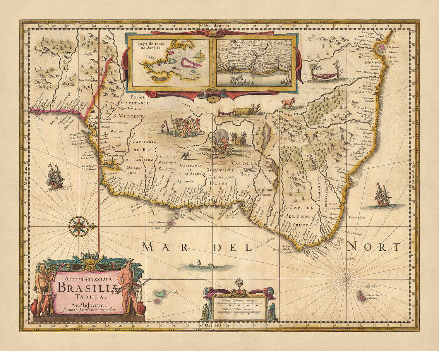
Immergiti nella ricca storia e nella geografia mozzafiato del Brasile con l'esclusiva 'Accuratissima Brasiliae tabula', tradotta come 'La Mappa Più Accurata del Brasile', una mappa meticolosamente realizzata nel 1690 dal rinomato cartografo Nicolaes Visscher II. Questo splendido capolavoro cartografico cattura l'essenza del Brasile alla fine del XVII secolo, offrendo uno sguardo nel passato con la sua rappresentazione delle divisioni politiche e delle regioni che compongono l'area moderna del Brasile. Visscher, discendente del celebre cartografo Claes Janszoon Visscher, porta la tradizione familiare di precisione e arte in questo pezzo unico.
La mappa presenta città significative come Rio De Janeiro, São Paulo, Salvador, São Luís e Natal, ognuna contrassegnata con meticolosa attenzione ai dettagli. Oltre ai paesaggi urbani, la mappa evidenzia anche vari elementi naturali, come corsi d'acqua, canali e montagne, che contribuiscono al variegato terreno brasiliano. I contorni colorati a mano e i dettagli incisi aggiungono un ulteriore livello di attrattiva visiva, rendendo questa mappa non solo un documento storico, ma anche un'opera d'arte.
Un aspetto interessante di questa mappa è l'inclusione di cartigli decorativi, una rosa dei venti e una vignetta di navi nell'oceano e insediamenti nativi nell'entroterra. Questi dettagli offrono un senso delle sensibilità estetiche e delle pratiche di navigazione dell'epoca. Il rilievo mostrato in modo pittorico migliora ulteriormente l'attrattiva visiva della mappa, fornendo una prospettiva tridimensionale che dà vita al paesaggio.
La 'Accuratissima Brasiliae tabula' è più di una semplice mappa: è una testimonianza dell'artigianato dell'età dell'oro olandese, una finestra sul passato del Brasile e un pezzo d'arte affascinante. Che tu sia un appassionato di storia, un amante delle mappe o semplicemente qualcuno che apprezza l'arte fine, questa mappa è un'aggiunta preziosa a qualsiasi collezione. I suoi dettagli intricati e il significato storico la rendono un pezzo di conversazione affascinante, sicuro di intrigare e ispirare.
Alcune delle località significative mostrate su questa mappa:
Città nella Capitale di Rio de Janeiro 1. Rio de Janeiro - Conosciuta come São Sebastião do Rio de Janeiro, è stata fondata nel 1565. È nota per il suo porto naturale, la Baia di Guanabara. 2. São Paulo - Fondata nel 1554 come São Paulo dos Campos de Piratininga, è famosa per la sua storica missione gesuita.
Città nella Capitale di Bahia 1. Salvador - Fondata nel 1549, è stata la prima capitale del Brasile e un importante porto per il commercio degli schiavi. 2. Ilhéus - Conosciuta come Vila de São Jorge dos Ilhéus, è stata fondata nel 1534 ed è famosa per le sue piantagioni di cacao. 3. Porto Seguro - Fondata nel 1534, è il luogo dove Pedro Álvares Cabral sbarcò per la prima volta in Brasile.
Città nella Capitale di Pernambuco 1. Recife - Fondata nel 1537, era il principale porto della capitale ed è nota per le sue piantagioni di canna da zucchero. 2. Olinda - Fondata nel 1535, era la capitale originale della capitale.
Città nella Capitale di São Vicente 1. Santos - Fondata nel 1546, era un importante porto per l'esportazione di caffè e zucchero.
Città nello Stato di Maranhão 1. São Luís - Fondata nel 1612, è stata il primo tentativo dei francesi di stabilirsi in Brasile. 2. Belém - Fondata nel 1616, è stata la porta d'ingresso per l'esplorazione portoghese dell'Amazzonia.
Città nella Capitaneria di Espírito Santo 1. Vitória - Fondata nel 1551, era una posizione strategica per la difesa contro i corsari francesi.
Città nella Capitaneria di Paraíba 1. João Pessoa - Fondata nel 1585, era un luogo chiave per l'industria della canna da zucchero.
Città nella Capitaneria di Rio Grande 1. Natal - Fondata nel 1599, era una posizione strategica per i portoghesi contro le invasioni francesi e olandesi.
Le restanti 17 città erano insediamenti più piccoli, ma comunque di importanza storica.
Fenomeni Naturali Notevoli - Fiume Amazonas - Uno dei fiumi più lunghi del mondo, è una via d'acqua principale per il trasporto e il commercio. - Pantanal - La più grande zona umida tropicale del mondo, è la casa di una vasta gamma di fauna selvatica. - Cascate dell'Iguaçu - Situate al confine tra Argentina e Brasile, sono una delle cascate più grandi del mondo. - Parco Nazionale Serra da Capivara - Conosciuto per i suoi dipinti rupestri preistorici. - Fernando de Noronha - Un arcipelago noto per la sua ricca biodiversità marina.
Eventi Storici - L'occupazione olandese del Brasile nordorientale (1630-1654) - Questo è stato un periodo significativo di conflitto e scambio culturale. - La Battaglia di Guararapes (1648-1649) - Ha segnato l'inizio della fine dell'occupazione olandese in Brasile. - La scoperta dell'oro nella regione di Minas Gerais (1693) - Questo ha portato alla più grande corsa all'oro in America Latina.
Si prega di controllare attentamente le immagini per assicurarsi che una specifica città o luogo sia mostrato su questa mappa. Puoi anche contattarci e chiedere di controllare la mappa per te.
Questa mappa appare fantastica in tutte le dimensioni: 12x16in (30.5x41cm), 16x20in (40.5x51cm), 18x24in (45.5x61cm), 24x30in (61x76cm), 32x40in (81.5x102cm), 40x50in (102x127cm), 48x60in (122x153cm) e 56x70in (142x178cm), ma appare ancora meglio se stampata in grande.
Posso creare stampe belle e grandi di questa mappa fino a 90in (229cm). Si prega di contattarmi se stai cercando opzioni di incorniciatura più grandi, personalizzate o diverse.
Il modello nelle immagini dell'inserzione tiene la versione 16x20in (40.5x51cm) di questa mappa.
La quinta immagine dell'inserzione mostra un esempio del mio servizio di personalizzazione della mappa.
Se stai cercando qualcosa di leggermente diverso, dai un'occhiata alla mia collezione delle migliori vecchie mappe d'Europa e delle città europee per vedere se qualcosa attira la tua attenzione.
Si prega di contattarmi per verificare se una certa posizione, punto di riferimento o caratteristica è mostrata su questa mappa.
Questo sarebbe un meraviglioso regalo per un compleanno, Natale, Festa del Papà, partenza dal lavoro, anniversario o inaugurazione della casa per qualcuno delle aree coperte da questa mappa.
Questa mappa è disponibile come stampa giclée su carta opaca archivistica senza acidi, oppure puoi acquistarla incorniciata. La cornice è una semplice cornice nera che si adatta alla maggior parte delle estetiche. Si prega di contattarmi se desideri un colore o materiale di cornice diverso. Le mie cornici sono dotate di un vetro acrilico super chiaro di grado museale (perspex/acrylite), che è significativamente meno riflettente del vetro, più sicuro e arriverà sempre in condizioni perfette.
This map is also available as a float framed canvas, sometimes known as a shadow gap framed canvas or canvas floater. The map is printed on artist's cotton canvas and then stretched over a handmade box frame. We then "float" the canvas inside a wooden frame, which is available in a range of colours (black, dark brown, oak, antique gold and white). This is a wonderful way to present a map without glazing in front. See some examples of float framed canvas maps and explore the differences between my different finishes.
For something truly unique, this map is also available in "Unique 3D", our trademarked process that dramatically transforms the map so that it has a wonderful sense of depth. We combine the original map with detailed topography and elevation data, so that mountains and the terrain really "pop". For more info and examples of 3D maps, check my Unique 3D page.
For most orders, delivery time is about 3 working days. Personalised and customised products take longer, as I have to do the personalisation and send it to you for approval, which usually takes 1 or 2 days.
Please note that very large framed orders usually take longer to make and deliver.
If you need your order to arrive by a certain date, please contact me before you order so that we can find the best way of making sure you get your order in time.
I print and frame maps and artwork in 23 countries around the world. This means your order will be made locally, which cuts down on delivery time and ensures that it won't be damaged during delivery. You'll never pay customs or import duty, and we'll put less CO2 into the air.
All of my maps and art prints are well packaged and sent in a rugged tube if unframed, or surrounded by foam if framed.
I try to send out all orders within 1 or 2 days of receiving your order, though some products (like face masks, mugs and tote bags) can take longer to make.
If you select Express Delivery at checkout your order we will prioritise your order and send it out by 1-day courier (Fedex, DHL, UPS, Parcelforce).
Next Day delivery is also available in some countries (US, UK, Singapore, UAE) but please try to order early in the day so that we can get it sent out on time.
My standard frame is a gallery style black ash hardwood frame. It is simple and quite modern looking. My standard frame is around 20mm (0.8in) wide.
I use super-clear acrylic (perspex/acrylite) for the frame glass. It's lighter and safer than glass - and it looks better, as the reflectivity is lower.
Six standard frame colours are available for free (black, dark brown, dark grey, oak, white and antique gold). Custom framing and mounting/matting is available if you're looking for something else.
Most maps, art and illustrations are also available as a framed canvas. We use matte (not shiny) cotton canvas, stretch it over a sustainably sourced box wood frame, and then 'float' the piece within a wood frame. The end result is quite beautiful, and there's no glazing to get in the way.
All frames are provided "ready to hang", with either a string or brackets on the back. Very large frames will have heavy duty hanging plates and/or a mounting baton. If you have any questions, please get in touch.
See some examples of my framed maps and framed canvas maps.
Alternatively, I can also supply old maps and artwork on canvas, foam board, cotton rag and other materials.
If you want to frame your map or artwork yourself, please read my size guide first.
My maps are extremely high quality reproductions of original maps.
I source original, rare maps from libraries, auction houses and private collections around the world, restore them at my London workshop, and then use specialist giclée inks and printers to create beautiful maps that look even better than the original.
My maps are printed on acid-free archival matte (not glossy) paper that feels very high quality and almost like card. In technical terms the paper weight/thickness is 10mil/200gsm. It's perfect for framing.
I print with Epson ultrachrome giclée UV fade resistant pigment inks - some of the best inks you can find.
I can also make maps on canvas, cotton rag and other exotic materials.
Learn more about The Unique Maps Co.
Map personalisation
If you're looking for the perfect anniversary or housewarming gift, I can personalise your map to make it truly unique. For example, I can add a short message, or highlight an important location, or add your family's coat of arms.
The options are almost infinite. Please see my map personalisation page for some wonderful examples of what's possible.
To order a personalised map, select "personalise your map" before adding it to your basket.
Get in touch if you're looking for more complex customisations and personalisations.
Map ageing
I have been asked hundreds of times over the years by customers if they could buy a map that looks even older.
Well, now you can, by selecting Aged before you add a map to your basket.
All the product photos you see on this page show the map in its Original form. This is what the map looks like today.
If you select Aged, I will age your map by hand, using a special and unique process developed through years of studying old maps, talking to researchers to understand the chemistry of aging paper, and of course... lots of practice!
If you're unsure, stick to the Original colour of the map. If you want something a bit darker and older looking, go for Aged.
Se non sei soddisfatto del tuo ordine per qualsiasi motivo, contattami per un rimborso senza problemi. Si prega di consultare la nostra politica di reso e rimborso per ulteriori informazioni.
Sono molto sicuro che ti piacerà la tua mappa restaurata o la stampa d'arte. Lo faccio dal 1984. Sono un venditore Etsy a 5 stelle. Ho venduto decine di migliaia di mappe e stampe d'arte e ho oltre 5.000 recensioni reali a 5 stelle.
Utilizzo un processo unico per restaurare mappe e opere d'arte che richiede molto tempo e lavoro. Trovare le mappe e le illustrazioni originali può richiedere mesi. Utilizzo tecnologia all'avanguardia e incredibilmente costosa per scannerizzare e restaurarle. Di conseguenza, garantisco che le mie mappe e stampe d'arte siano superiori alle altre - ecco perché posso offrire un rimborso senza problemi.
Quasi tutte le mie mappe e stampe d'arte sembrano fantastiche a grandi dimensioni (200 cm, 6,5 piedi+) e posso anche incorniciarle e consegnarle a te, tramite un corriere speciale per oggetti di grandi dimensioni. Contattami per discutere delle tue esigenze specifiche.
Or try searching for something!


