

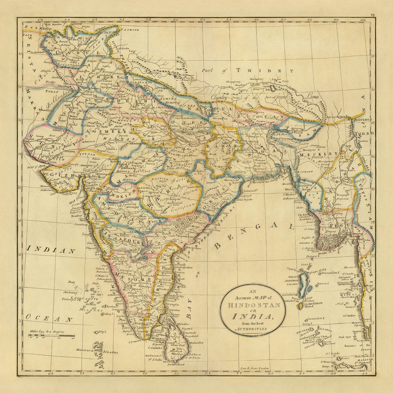


Mappa antica dell'India, Pakistan e Bangladesh di Carey, 1814: Hindoostan, Ceylon, Birmania, Isole Andamane, Golfo del Bengala
20% di sconto su 2 — 33% di sconto su 3
Aggiungi qualsiasi due articoli idonei al tuo carrello per ricevere 20% di sconto. Aggiungi un terzo e sarà gratuito (equivalente a 33% di sconto quando acquisti tre).
Nessun codice necessario — l'offerta si applica automaticamente al checkout.
Valido su tutte le mappe standard e le stampe d'arte fine. Puoi mescolare e abbinare qualsiasi design.
Se desideri spedire articoli a più indirizzi, ti preghiamo di contattarci prima di effettuare il tuo ordine.
Le commissioni personalizzate e su misura sono escluse.
Contattaci se hai domande
- All taxes and duties included
- Handmade & dispatched in 1-2 days
-
Complimentary gifting & design advice
ⓘ
Complimentary gifting & design advice
Available almost 24/7 on WhatsApp and email — we usually reply within minutes. We can help you:
- Choose a perfectly personalised gift
- Send a digital gift preview to the recipient
- Pick the ideal size for your wall
- Select the right finish and frame
Quick, friendly advice so you can order with confidence.
For last minute gifts, consider buying a digital gift card. We have over 5,000 maps and art prints to choose from.
-
90-day returns & 5-year guarantee
ⓘ
90 giorni per restituire e ricevere un rimborso
I prodotti possono essere restituiti entro 90 giorni per un rimborso completo, o cambio con un altro prodotto.
Per articoli personalizzati e su misura, potremmo offrirti un credito in negozio o una carta regalo non scadente, poiché non possiamo rivendere ordini personalizzati.
Se hai domande, contattaci. Per ulteriori informazioni, consulta la nostra politica di restituzione e cambio.

This is a museum-grade archival print from the original 1814 map — restored in our workshop and made to order on 220gsm archival matte paper or 400gsm artist's cotton canvas with pigment inks.
Professional framing & free personalisation available.
1. Choose a size
2. Frame & personalise your map
Make your map unique with framing, hand-drawn customisation, vintage ageing, pop art text, unique 3D styling and more.


Gift message & custom finish

If you want to add a gift message, or a finish (jigsaw, aluminium board, etc.) that is not available here, please request it in the "order note" when you check out.
Every order is custom made, so if you need the size adjusted slightly, or printed on an unusual material, just let us know. We've done thousands of custom orders over the years, so there's (almost) nothing we can't manage.
You can also contact us before you order, if you prefer!

- Handmade locally. No import duty or tax
- FREE worldwide delivery
- 90-day returns & 5-year product guarantee
- Questions? WhatsApp me any time
Own a piece of history
7,000+ 5 star reviews


"Una Mappa Accurata dell'Hindostan e dell'India, dalle migliori autorità" è un pezzo straordinario della storia cartografica, meticolosamente realizzato da Mathew Carey nel 1814. Carey, un rinomato editore con sede a Filadelfia, è stato una delle figure pionieristiche nella creazione di mappe americane, e questa mappa è una testimonianza della sua eccezionale abilità e dedizione. L'attenzione della mappa è sui paesi dell'India, del Pakistan e del Bangladesh, ma si estende per includere la costa occidentale della Penisola Malese, a nord fino al Tibet e a Kabul. Questo ampio ambito geografico, combinato con le rappresentazioni politiche e fisiche dettagliate della mappa, la rendono una rappresentazione affascinante della regione all'inizio del XIX secolo.
Il soggetto principale della mappa è l'India, ma fornisce anche una rappresentazione dettagliata delle regioni circostanti, inclusi l'Hindoostan, Ceylon, Birmania, le Isole Andamane e il Golfo del Bengala. Queste aree sono rappresentate con notevole precisione, riflettendo l'impegno di Carey per l'accuratezza e il dettaglio. Lo stile della mappa è sia politico che fisico, offrendo una visione completa dei confini politici e dei paesaggi fisici della regione. Il risultato è una rappresentazione riccamente stratificata che fornisce una grande quantità di informazioni sulla geografia e il panorama politico della regione.
La mappa di Carey è particolarmente notevole per la sua rappresentazione dell'India, che è stata una delle prime del suo genere a essere stampata in America. La mappa fornisce una vista dettagliata delle città, dei paesi e delle regioni del paese, così come dei suoi fenomeni naturali e dei suoi punti di riferimento. Offre anche uno sguardo nel contesto storico dell'epoca, fornendo una prospettiva unica sui cambiamenti politici e geografici della regione all'inizio del XIX secolo.
In conclusione, "Una Mappa Accurata dell'Hindostan e dell'India, dalle migliori autorità" è un pezzo notevole della storia cartografica. La sua rappresentazione dettagliata dell'India e delle regioni circostanti, combinata con la sua importanza storica come una delle prime mappe dell'India stampate in America, la rendono un'aggiunta preziosa a qualsiasi collezione. L'attenzione meticolosa ai dettagli della mappa, dalla sua precisa rappresentazione di città e paesi alla sua intricato resa di fenomeni naturali e punti di riferimento, riflette l'impegno di Carey per l'accuratezza e la sua abilità come cartografo. Questa mappa non è solo una rappresentazione geografica, ma una finestra sul passato, offrendo una prospettiva unica su una regione affascinante durante un momento cruciale della storia.
Data l'attenzione della mappa all'India, al Pakistan e al Bangladesh, così come alle regioni circostanti, i seguenti punti di interesse sono coperti:
India:
- Città principali come Delhi, Mumbai e Kolkata
- Punti di riferimento storici come il Taj Mahal ad Agra
- Il fiume Gange, una caratteristica naturale significativa
- Il deserto del Thar, un'altra caratteristica naturale notevole
Pakistan:
- Città principali come Karachi, Lahore e Islamabad
- Il fiume Indo, una caratteristica naturale significativa
- Il Passo Khyber, una storica via commerciale
Bangladesh:
- Città principali come Dhaka e Chittagong
- Le Sundarbans, la più grande foresta di mangrovie del mondo
- Il delta del Gange-Brahmaputra, una caratteristica naturale significativa
Hindoostan:
- Città principali come Varanasi e Jaipur
- La catena montuosa dell'Himalaya, una caratteristica naturale significativa
- Punti di riferimento storici come il Forte Rosso di Delhi
Ceylon (l'attuale Sri Lanka):
- Città principali come Colombo e Kandy
- Le Highlands Centrali, una caratteristica naturale significativa
- Monumenti storici come il Tempio del Dente a Kandy
Birmania (Myanmar moderno):
- Città principali come Yangon e Mandalay
- Il fiume Irrawaddy, una caratteristica naturale significativa
- Monumenti storici come la Pagoda Shwedagon a Yangon
Isole Andamane:
- Le tribù Great Andamanese, abitanti indigeni delle isole
- La biodiversità unica delle isole
Baia del Bengala:
- Il ruolo significativo che svolge nel clima della regione
- Il Delta del Sundarbans, il delta più grande del mondo formato dai fiumi Gange, Brahmaputra e Meghna.
Si prega di controllare attentamente le immagini per assicurarsi che una specifica città o luogo sia mostrato su questa mappa. Puoi anche contattarci e chiedere di controllare la mappa per te.
Questa mappa sembra fantastica in ogni dimensione, ma consiglio sempre di optare per una dimensione più grande se hai spazio. In questo modo puoi facilmente distinguere tutti i dettagli.
Questa mappa sembra straordinaria in dimensioni fino a 70in (180cm). Se stai cercando una mappa più grande, per favore contattaci.
Il modello nelle immagini dell'inserzione tiene la versione 18x18in (45x55cm) di questa mappa.
La quinta immagine dell'inserzione mostra un esempio del mio servizio di personalizzazione della mappa.
Se stai cercando qualcosa di leggermente diverso, dai un'occhiata alla mia collezione delle migliori mappe antiche per vedere se qualcosa attira la tua attenzione.
Si prega di contattarmi per verificare se una certa posizione, monumento o caratteristica è mostrata su questa mappa.
Questo sarebbe un meraviglioso regalo per un compleanno, Natale, Festa del Papà, lasciato dal lavoro, anniversario o per una festa di inaugurazione per qualcuno delle aree coperte da questa mappa.
Questa mappa è disponibile come stampa giclée su carta opaca archivistica priva di acidi, oppure puoi acquistarla incorniciata. La cornice è una semplice cornice nera che si adatta alla maggior parte degli stili. Per favore, contattami se desideri un colore o un materiale di cornice diverso. Le mie cornici sono dotate di un acrilico museo super chiaro (perspex/acrylite), che è significativamente meno riflettente del vetro, più sicuro e arriverà sempre in perfette condizioni.
This map is also available as a float framed canvas, sometimes known as a shadow gap framed canvas or canvas floater. The map is printed on artist's cotton canvas and then stretched over a handmade box frame. We then "float" the canvas inside a wooden frame, which is available in a range of colours (black, dark brown, oak, antique gold and white). This is a wonderful way to present a map without glazing in front. See some examples of float framed canvas maps and explore the differences between my different finishes.
For something truly unique, this map is also available in "Unique 3D", our trademarked process that dramatically transforms the map so that it has a wonderful sense of depth. We combine the original map with detailed topography and elevation data, so that mountains and the terrain really "pop". For more info and examples of 3D maps, check my Unique 3D page.
For most orders, delivery time is about 3 working days. Personalised and customised products take longer, as I have to do the personalisation and send it to you for approval, which usually takes 1 or 2 days.
Please note that very large framed orders usually take longer to make and deliver.
If you need your order to arrive by a certain date, please contact me before you order so that we can find the best way of making sure you get your order in time.
I print and frame maps and artwork in 23 countries around the world. This means your order will be made locally, which cuts down on delivery time and ensures that it won't be damaged during delivery. You'll never pay customs or import duty, and we'll put less CO2 into the air.
All of my maps and art prints are well packaged and sent in a rugged tube if unframed, or surrounded by foam if framed.
I try to send out all orders within 1 or 2 days of receiving your order, though some products (like face masks, mugs and tote bags) can take longer to make.
If you select Express Delivery at checkout your order we will prioritise your order and send it out by 1-day courier (Fedex, DHL, UPS, Parcelforce).
Next Day delivery is also available in some countries (US, UK, Singapore, UAE) but please try to order early in the day so that we can get it sent out on time.
My standard frame is a gallery style black ash hardwood frame. It is simple and quite modern looking. My standard frame is around 20mm (0.8in) wide.
I use super-clear acrylic (perspex/acrylite) for the frame glass. It's lighter and safer than glass - and it looks better, as the reflectivity is lower.
Six standard frame colours are available for free (black, dark brown, dark grey, oak, white and antique gold). Custom framing and mounting/matting is available if you're looking for something else.
Most maps, art and illustrations are also available as a framed canvas. We use matte (not shiny) cotton canvas, stretch it over a sustainably sourced box wood frame, and then 'float' the piece within a wood frame. The end result is quite beautiful, and there's no glazing to get in the way.
All frames are provided "ready to hang", with either a string or brackets on the back. Very large frames will have heavy duty hanging plates and/or a mounting baton. If you have any questions, please get in touch.
See some examples of my framed maps and framed canvas maps.
Alternatively, I can also supply old maps and artwork on canvas, foam board, cotton rag and other materials.
If you want to frame your map or artwork yourself, please read my size guide first.
Alcune delle mie vecchie mappe sono ora disponibili come tele incorniciate. Per favore contattami se desideri ordinare una dimensione che non è disponibile nel mio negozio.
Le vecchie mappe su tela sono un'alternativa interessante alle mappe incorniciate in modo convenzionale. A seconda del tuo gusto personale e dell'arredamento della stanza, le mappe su tela possono "risaltare" un po' di più rispetto a una mappa incorniciata.
My maps are extremely high quality reproductions of original maps.
I source original, rare maps from libraries, auction houses and private collections around the world, restore them at my London workshop, and then use specialist giclée inks and printers to create beautiful maps that look even better than the original.
My maps are printed on acid-free archival matte (not glossy) paper that feels very high quality and almost like card. In technical terms the paper weight/thickness is 10mil/200gsm. It's perfect for framing.
I print with Epson ultrachrome giclée UV fade resistant pigment inks - some of the best inks you can find.
I can also make maps on canvas, cotton rag and other exotic materials.
Learn more about The Unique Maps Co.
Map personalisation
If you're looking for the perfect anniversary or housewarming gift, I can personalise your map to make it truly unique. For example, I can add a short message, or highlight an important location, or add your family's coat of arms.
The options are almost infinite. Please see my map personalisation page for some wonderful examples of what's possible.
To order a personalised map, select "personalise your map" before adding it to your basket.
Get in touch if you're looking for more complex customisations and personalisations.
Map ageing
I have been asked hundreds of times over the years by customers if they could buy a map that looks even older.
Well, now you can, by selecting Aged before you add a map to your basket.
All the product photos you see on this page show the map in its Original form. This is what the map looks like today.
If you select Aged, I will age your map by hand, using a special and unique process developed through years of studying old maps, talking to researchers to understand the chemistry of aging paper, and of course... lots of practice!
If you're unsure, stick to the Original colour of the map. If you want something a bit darker and older looking, go for Aged.
Se non sei soddisfatto del tuo ordine per qualsiasi motivo, contattami per un rimborso senza problemi. Si prega di consultare la nostra politica di reso e rimborso per ulteriori informazioni.
Sono molto sicuro che ti piacerà la tua mappa restaurata o la stampa d'arte. Lo faccio dal 1984. Sono un venditore Etsy a 5 stelle. Ho venduto decine di migliaia di mappe e stampe d'arte e ho oltre 5.000 recensioni reali a 5 stelle.
Utilizzo un processo unico per restaurare mappe e opere d'arte che richiede molto tempo e lavoro. Trovare le mappe e le illustrazioni originali può richiedere mesi. Utilizzo tecnologia all'avanguardia e incredibilmente costosa per scannerizzare e restaurarle. Di conseguenza, garantisco che le mie mappe e stampe d'arte siano superiori alle altre - ecco perché posso offrire un rimborso senza problemi.
Quasi tutte le mie mappe e stampe d'arte sembrano fantastiche a grandi dimensioni (200 cm, 6,5 piedi+) e posso anche incorniciarle e consegnarle a te, tramite un corriere speciale per oggetti di grandi dimensioni. Contattami per discutere delle tue esigenze specifiche.
Or try searching for something!


