


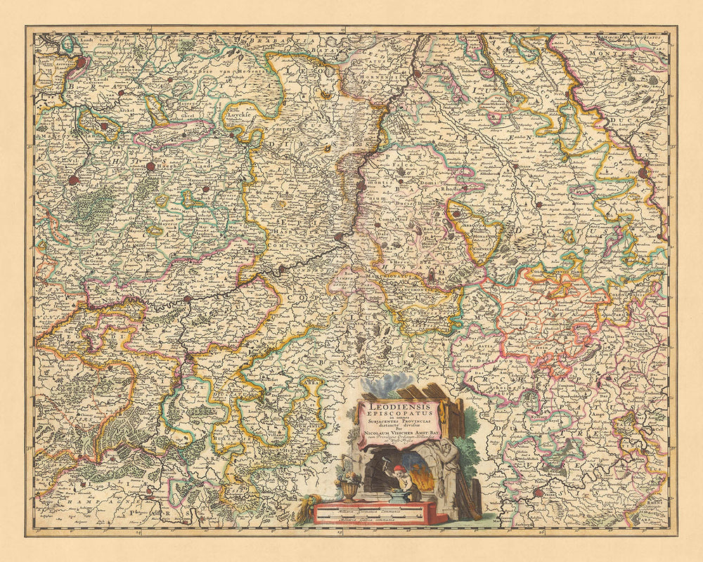


Mappa antica del Vescovato di Liegi, Belgio di Visscher, 1690: Bruxelles, Anversa, Colonia, Bonn, Düsseldorf
- All taxes and duties included
- Handmade & dispatched in 1-2 days
-
90 day money back guarantee
ⓘ
90 giorni per restituire e ottenere un rimborso
I prodotti possono essere restituiti entro 90 giorni per un rimborso completo, o scambio con un altro prodotto.
Per articoli personalizzati o su misura, potremmo offrirti un credito in negozio o una carta regalo non scadente, poiché non possiamo rivendere ordini personalizzati.
Se hai domande, contattaci. Per ulteriori informazioni, consulta la nostra politica di restituzione e scambio.

My maps are rare, museum-grade, restored old maps sourced from libraries, auction houses and private collections across the globe.
Framing & free personalisation available
1. Select your size
2. Frame & personalise your map
Make your map unique with framing, hand-drawn customisation, vintage ageing, pop art text, unique 3D styling and moreGift message & custom finish

If you want to add a gift message, or a finish (jigsaw, aluminium board, etc.) that is not available here, please request it in the "order note" when you check out.
Every order is custom made, so if you need the size adjusted slightly, or printed on an unusual material, just let us know. We've done thousands of custom orders over the years, so there's (almost) nothing we can't manage.
You can also contact us before you order, if you prefer!

- Handmade locally. No import duty or tax
- FREE Delivery. Arrives in 2-3 days
- Love it or your money back
- Questions? WhatsApp me any time
Own a piece of history
5,000+ 5 star reviews


Immergiti nella ricca storia del Vescovato di Liegi con questa mappa meticolosamente dettagliata realizzata da Nicolaes Visscher II nel 1690. La mappa, intitolata ufficialmente 'Leodiensis Episcopatus in omnes subjacentes provincias distincte divisus', si traduce in 'Il Vescovato di Liegi, distintamente diviso in tutte le province sottostanti'. Questo offre uno sguardo affascinante sulle divisioni politiche e geografiche dell'epoca, focalizzandosi specificamente sul Vescovato di Liegi, un significativo territorio ecclesiastico nell'area moderna del Belgio.
Nicolaes Visscher II, il creatore della mappa, proveniva da una stirpe di stimati cartografi dell'età d'oro olandese. Suo nonno, Claes Janszoon Visscher, era rinomato per le sue straordinarie abilità cartografiche, un'eredità che Nicolaes ha mantenuto con successo. Questa mappa è una testimonianza della precisione e dell'arte che la famiglia Visscher ha portato nel campo della cartografia.
Questa mappa non è solo una rappresentazione geografica ma anche un documento storico che cattura l'essenza della fine del XVII secolo. Presenta cinque città significative: Bruxelles, Anversa, Colonia, Bonn e Düsseldorf. Ogni città è rappresentata con le proprie caratteristiche uniche, offrendo un'interessante esplorazione dei paesaggi urbani della regione durante questo periodo.
La mappa evidenzia anche diversi punti di riferimento e caratteristiche geografiche che erano importanti durante questo periodo. Le divisioni politiche e i confini sono chiaramente segnati, fornendo una comprensione completa della struttura amministrativa della regione. Questa mappa offre una prospettiva inestimabile sul Vescovato di Liegi, rendendola un pezzo ideale per coloro che sono interessati alla storia, alla cartografia o al fascino unico delle vecchie mappe.
Alcune delle posizioni significative mostrate su questa mappa:
Vescovato di Liegi
- Bruxelles: Conosciuta come la capitale del Belgio oggi, Bruxelles era una città vivace anche nel 1690. Era storicamente nota come Bruxella o Bruocsella.
- Anversa: Nota per il suo distretto dei diamanti e il suo porto, Anversa era un importante centro di commercio e cultura. Era storicamente nota come Antwerpen.
- Liegi: La città da cui il Vescovato prende il nome, Liegi era un significativo centro ecclesiastico e politico. Era storicamente nota come Leodium.
- Namur: La capitale della Vallonia, Namur era una posizione strategica all'incontro dei fiumi Mosa e Sambre. Era storicamente nota come Namen.
- Tournai: Una delle città più antiche del Belgio, Tournai era nota per il suo patrimonio culturale e architettonico. Era storicamente nota come Tornacum.
- Mons: Conosciuta per la sua ricca storia e architettura, Mons era un importante centro di commercio e cultura. Era storicamente nota come Montes.
- Louvain: Conosciuta per la sua università storica, Louvain era un centro di apprendimento e studio. Era storicamente nota come Lovanium.
- Charleroi: Fondata nel 1666, Charleroi era una fortificazione sul fiume Sambre. Era storicamente nota come Charnoy.
- Hasselt: Conosciuta per le sue distillerie di jenever, Hasselt era un importante centro dell'industria degli alcolici. Era storicamente nota come Hassaluth.
- Verviers: Conosciuta per la sua industria della lana e del tessile, Verviers era un importante centro commerciale. Era storicamente nota come Vervia.
Ducato di Brabante
- 's-Hertogenbosch: Conosciuta per il suo centro città medievale ben conservato, 's-Hertogenbosch era un importante centro culturale. Era storicamente conosciuta come Silva Ducis.
- Breda: Conosciuta per il suo castello storico, Breda era un centro di nobiltà e potere. Era storicamente conosciuta come Brede.
- Tilburg: Conosciuta per la sua industria della lana, Tilburg era un importante centro commerciale. Era storicamente conosciuta come Tilborch.
- Eindhoven: Conosciuta per le sue industrie metalliche e tessili, Eindhoven era un importante centro commerciale. Era storicamente conosciuta come Endehoven.
- Roosendaal: Conosciuta per la sua posizione strategica sulla rotta commerciale tra Anversa e Rotterdam, Roosendaal era un importante centro commerciale. Era storicamente conosciuta come Rosendale.
Contea delle Fiandre
- Gent: Conosciuta per la sua industria della lana e il suo ricco patrimonio culturale, Gent era un importante centro di commercio e cultura. Era storicamente conosciuta come Gandavum.
- Bruges: Conosciuta per i suoi canali e il suo centro città storico, Bruges era un centro di commercio e cultura. Era storicamente conosciuta come Brugge.
- Kortrijk: Conosciuta per la sua industria del lino, Kortrijk era un importante centro commerciale. Era storicamente conosciuta come Cortoriacum.
- Ostenda: Conosciuta per il suo porto, Ostenda era un importante centro di commercio marittimo. Era storicamente conosciuta come Ostende.
- Roeselare: Conosciuta per le sue industrie di lino e merletto, Roeselare era un importante centro commerciale. Era storicamente conosciuta come Roslar.
Fenomeni naturali notevoli:
- Il fiume Mosa: Un importante fiume europeo che scorre attraverso Francia, Belgio e Paesi Bassi.
- Il fiume Sambre: Un fiume nel nord della Francia e in Wallonia, Belgio, è un affluente di sinistra del Mosa.
- Le Ardenne: Una regione di ampie foreste, terreni accidentati, colline e creste.
- Il Parco Nazionale Hoge Kempen: Un parco nazionale situato nella provincia belga di Limburg.
- Le Alte Torbiere: Un'area di torbiere nella provincia di Liège.
Eventi storici notevoli:
- La Guerra dei Trent'Anni (1568–1648): Una rivolta delle Diciassette Province contro l'egemonia politica e religiosa di Filippo II di Spagna.
- La Guerra Franco-Olandese (1672–1678): La Francia, alleata con l'Inghilterra, invase i Paesi Bassi nel tentativo di espandere il suo territorio.
- Il Trattato di Nijmegen (1678): Il trattato pose fine a varie guerre interconnesse tra Francia, Repubblica Olandese, Spagna, Brandeburgo, Svezia, Danimarca, il Principato-Vescovato di Münster e il Sacro Romano Impero.
Si prega di controllare attentamente le immagini per assicurarsi che una specifica città o luogo sia mostrato su questa mappa. Puoi anche contattarci e chiedere di controllare la mappa per te.
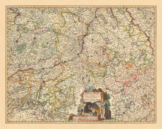
Questa mappa appare ottima in tutte le dimensioni: 12x16in (30.5x41cm), 16x20in (40.5x51cm), 18x24in (45.5x61cm), 24x30in (61x76cm), 32x40in (81.5x102cm), 40x50in (102x127cm), 48x60in (122x153cm) e 56x70in (142x178cm), ma appare ancora meglio se stampata in grande.
Posso creare bellissime stampe grandi di questa mappa fino a 90in (229cm). Si prega di contattarci se stai cercando opzioni di stampa più grandi, personalizzate o diverse.
Il modello nelle immagini dell'annuncio tiene la versione di questa mappa da 16x20in (40.5x51cm).
La quinta immagine dell'annuncio mostra un esempio del mio servizio di personalizzazione della mappa.
Se stai cercando qualcosa di leggermente diverso, dai un'occhiata alla mia collezione delle migliori mappe antiche d'Europa e delle città europee per vedere se qualcosa attira la tua attenzione.
Per favore contattami per verificare se una certa posizione, un punto di riferimento o una caratteristica è mostrata su questa mappa.
Questo sarebbe un regalo meraviglioso per un compleanno, Natale, Festa del Papà, congedo dal lavoro, anniversario o inaugurazione della casa per qualcuno delle aree coperte da questa mappa.
Questa mappa è disponibile come stampa giclée su carta opaca archiviabile senza acidi, oppure puoi acquistarla incorniciata. La cornice è una semplice cornice nera che si adatta alla maggior parte degli stili. Per favore contattami se desideri un colore o un materiale diverso per la cornice. Le mie cornici sono vetriate con un acrilico super chiaro di qualità museale (perspex/acrylite), che è significativamente meno riflettente del vetro, più sicuro e arriverà sempre in condizioni perfette.
This map is also available as a float framed canvas, sometimes known as a shadow gap framed canvas or canvas floater. The map is printed on artist's cotton canvas and then stretched over a handmade box frame. We then "float" the canvas inside a wooden frame, which is available in a range of colours (black, dark brown, oak, antique gold and white). This is a wonderful way to present a map without glazing in front. See some examples of float framed canvas maps and explore the differences between my different finishes.
For something truly unique, this map is also available in "Unique 3D", our trademarked process that dramatically transforms the map so that it has a wonderful sense of depth. We combine the original map with detailed topography and elevation data, so that mountains and the terrain really "pop". For more info and examples of 3D maps, check my Unique 3D page.
For most orders, delivery time is about 3 working days. Personalised and customised products take longer, as I have to do the personalisation and send it to you for approval, which usually takes 1 or 2 days.
Please note that very large framed orders usually take longer to make and deliver.
If you need your order to arrive by a certain date, please contact me before you order so that we can find the best way of making sure you get your order in time.
I print and frame maps and artwork in 23 countries around the world. This means your order will be made locally, which cuts down on delivery time and ensures that it won't be damaged during delivery. You'll never pay customs or import duty, and we'll put less CO2 into the air.
All of my maps and art prints are well packaged and sent in a rugged tube if unframed, or surrounded by foam if framed.
I try to send out all orders within 1 or 2 days of receiving your order, though some products (like face masks, mugs and tote bags) can take longer to make.
If you select Express Delivery at checkout your order we will prioritise your order and send it out by 1-day courier (Fedex, DHL, UPS, Parcelforce).
Next Day delivery is also available in some countries (US, UK, Singapore, UAE) but please try to order early in the day so that we can get it sent out on time.
My standard frame is a gallery style black ash hardwood frame. It is simple and quite modern looking. My standard frame is around 20mm (0.8in) wide.
I use super-clear acrylic (perspex/acrylite) for the frame glass. It's lighter and safer than glass - and it looks better, as the reflectivity is lower.
Six standard frame colours are available for free (black, dark brown, dark grey, oak, white and antique gold). Custom framing and mounting/matting is available if you're looking for something else.
Most maps, art and illustrations are also available as a framed canvas. We use matte (not shiny) cotton canvas, stretch it over a sustainably sourced box wood frame, and then 'float' the piece within a wood frame. The end result is quite beautiful, and there's no glazing to get in the way.
All frames are provided "ready to hang", with either a string or brackets on the back. Very large frames will have heavy duty hanging plates and/or a mounting baton. If you have any questions, please get in touch.
See some examples of my framed maps and framed canvas maps.
Alternatively, I can also supply old maps and artwork on canvas, foam board, cotton rag and other materials.
If you want to frame your map or artwork yourself, please read my size guide first.
Alcune delle mie vecchie mappe sono ora disponibili come tele incorniciate. Per favore contattami se desideri ordinare una dimensione che non è disponibile nel mio negozio.
Le vecchie mappe su tela sono un'alternativa interessante alle mappe incorniciate in modo convenzionale. A seconda del tuo gusto personale e dell'arredamento della stanza, le mappe su tela possono "risaltare" un po' di più rispetto a una mappa incorniciata.
My maps are extremely high quality reproductions of original maps.
I source original, rare maps from libraries, auction houses and private collections around the world, restore them at my London workshop, and then use specialist giclée inks and printers to create beautiful maps that look even better than the original.
My maps are printed on acid-free archival matte (not glossy) paper that feels very high quality and almost like card. In technical terms the paper weight/thickness is 10mil/200gsm. It's perfect for framing.
I print with Epson ultrachrome giclée UV fade resistant pigment inks - some of the best inks you can find.
I can also make maps on canvas, cotton rag and other exotic materials.
Learn more about The Unique Maps Co.
Map personalisation
If you're looking for the perfect anniversary or housewarming gift, I can personalise your map to make it truly unique. For example, I can add a short message, or highlight an important location, or add your family's coat of arms.
The options are almost infinite. Please see my map personalisation page for some wonderful examples of what's possible.
To order a personalised map, select "personalise your map" before adding it to your basket.
Get in touch if you're looking for more complex customisations and personalisations.
Map ageing
I have been asked hundreds of times over the years by customers if they could buy a map that looks even older.
Well, now you can, by selecting Aged before you add a map to your basket.
All the product photos you see on this page show the map in its Original form. This is what the map looks like today.
If you select Aged, I will age your map by hand, using a special and unique process developed through years of studying old maps, talking to researchers to understand the chemistry of aging paper, and of course... lots of practice!
If you're unsure, stick to the Original colour of the map. If you want something a bit darker and older looking, go for Aged.
Se non sei soddisfatto del tuo ordine per qualsiasi motivo, contattami per un rimborso senza problemi. Si prega di consultare la nostra politica di reso e rimborso per ulteriori informazioni.
Sono molto sicuro che ti piacerà la tua mappa restaurata o la stampa d'arte. Lo faccio dal 1984. Sono un venditore Etsy a 5 stelle. Ho venduto decine di migliaia di mappe e stampe d'arte e ho oltre 5.000 recensioni reali a 5 stelle.
Utilizzo un processo unico per restaurare mappe e opere d'arte che richiede molto tempo e lavoro. Trovare le mappe e le illustrazioni originali può richiedere mesi. Utilizzo tecnologia all'avanguardia e incredibilmente costosa per scannerizzare e restaurarle. Di conseguenza, garantisco che le mie mappe e stampe d'arte siano superiori alle altre - ecco perché posso offrire un rimborso senza problemi.
Quasi tutte le mie mappe e stampe d'arte sembrano fantastiche a grandi dimensioni (200 cm, 6,5 piedi+) e posso anche incorniciarle e consegnarle a te, tramite un corriere speciale per oggetti di grandi dimensioni. Contattami per discutere delle tue esigenze specifiche.
Or try searching for something!


