


Mappa antica della Columbia Britannica dei Fratelli Poole, 1911: Vancouver, Victoria, Ferrovie, Rotte di Navi a Vapore, Isola di Vancouver
- All taxes and duties included
- Handmade & dispatched in 1-2 days
-
FREE gift preview
ⓘ
Digital gift preview
New for 2025: After you complete your order, you can send a beautiful digital preview to the gift recipient. Just provide their email address and we'll do the rest. (Their email address will not be stored or used for any other purpose.)
This is perfect for Christmas gifting, particularly if you're concerned that your order might not arrive in time for Christmas.
-
90 day money back guarantee
ⓘ
90 giorni per restituire e ricevere un rimborso
I prodotti possono essere restituiti entro 90 giorni per un rimborso completo, o cambio con un altro prodotto.
Per articoli personalizzati e su misura, potremmo offrirti un credito in negozio o una carta regalo non scadente, poiché non possiamo rivendere ordini personalizzati.
Se hai domande, contattaci. Per ulteriori informazioni, consulta la nostra politica di restituzione e cambio.

My maps are rare, museum-grade, restored old maps sourced from libraries, auction houses and private collections across the globe.
Framing & free personalisation available
1. Select your size
2. Frame & personalise your map
There is limited framing & personalisation capacity available. Order by 10am tomorrow for Christmas delivery.


Gift message & custom finish

If you want to add a gift message, or a finish (jigsaw, aluminium board, etc.) that is not available here, please request it in the "order note" when you check out.
Every order is custom made, so if you need the size adjusted slightly, or printed on an unusual material, just let us know. We've done thousands of custom orders over the years, so there's (almost) nothing we can't manage.
You can also contact us before you order, if you prefer!

- Handmade locally. No import duty or tax
- FREE Delivery by Christmas
- Love it or your money back (90 days)
- Questions? WhatsApp me any time
Own a piece of history
5,000+ 5 star reviews


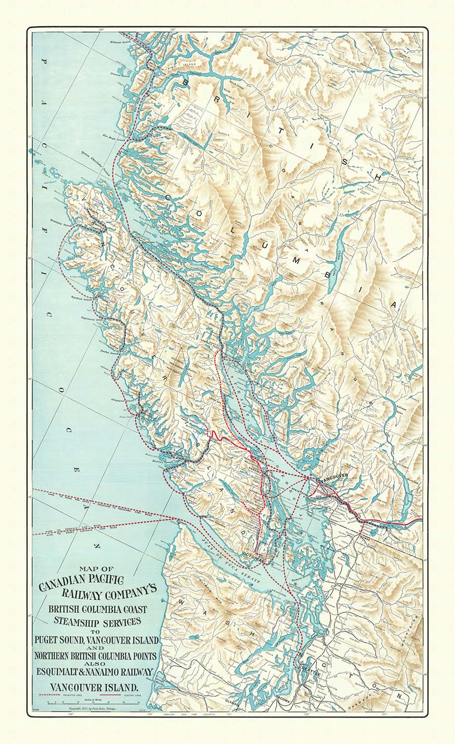
La "Mappa dei Servizi di Navigazione della Canadian Pacific Railway Company per la Costa della Columbia Britannica, Puget Sound, Vancouver Island e Punti del Nord della Columbia Britannica, nonché la Ferrovia Esquimalt & Nanaimo su Vancouver Island" è un affascinante reperto del 1911, realizzato dai rinomati Poole Brothers di Chicago. Questa mappa offre una finestra sul primo XX secolo, mostrando la complessa rete di percorsi ferroviari e di navigazione che erano fondamentali per plasmare il panorama economico del Pacific Northwest. I Poole Brothers, celebrati per la loro precisione e arte, hanno creato una mappa che non è solo funzionale ma anche un'opera d'arte, riflettendo la grandezza delle innovazioni nei trasporti dell'epoca.
La mappa combina elegantemente elementi politici e fisici, offrendo una vista dettagliata del terreno e delle rotte di trasporto. La delineazione accurata delle ferrovie, inclusa la Canadian Pacific Railway e la Esquimalt & Nanaimo Railway, illustra la crescente connettività dell'epoca. Le rotte acquatiche sono meticolosamente tracciate, evidenziando i servizi di navigazione che collegavano comunità remote a grandi centri urbani. Questa integrazione di rotte terrestri e marittime sottolinea l'importanza delle reti di trasporto nel favorire lo sviluppo regionale e la crescita economica.
Geograficamente, la mappa abbraccia i paesaggi mozzafiato della Columbia Britannica e dello stato di Washington occidentale. Cattura la bellezza aspra di Vancouver Island e le intricate vie d'acqua del Puget Sound. Le caratteristiche topografiche della mappa, come le linee costiere e le regioni montuose, sono rese con precisione, offrendo uno sguardo nella bellezza naturale che caratterizza questa parte del mondo. Queste caratteristiche non solo servivano come punti di riferimento per la navigazione, ma anche come simboli della natura selvaggia che veniva gradualmente esplorata e connessa.
Storicamente, questa mappa è una testimonianza del potere trasformativo delle infrastrutture di trasporto nei primi anni 1900. Riflette l'importanza strategica delle rotte ferroviarie e di navigazione nel facilitare il commercio e la mobilità, che erano cruciali per la crescita di città come Vancouver, Victoria e Seattle. La mappa cattura un momento nel tempo in cui il Pacific Northwest era sul punto della modernità, guidato dalle ambizioni della Canadian Pacific Railway Company e dalla sua visione di connettere le comunità attraverso vaste distanze.
La maestria dei Poole Brothers è evidente nel design della mappa, che bilancia funzionalità e appeal estetico. La loro attenzione ai dettagli e l'impegno per la qualità rendono questa mappa non solo un prezioso documento storico, ma anche un pezzo da collezione. Essa rimane un promemoria di un'epoca in cui le mappe non erano solo strumenti di navigazione, ma anche espressioni dell'impegno umano per tracciare e comprendere il mondo.
Città e paesi su questa mappa
- Vancouver
- Victoria
- Nanaimo
- Prince Rupert
- Seattle
- Tacoma
- Bellingham
Caratteristiche e punti di riferimento notevoli
- Ferrovie:
- Canadian Pacific Railway
- Esquimalt & Nanaimo Railway
- Rotte acquatiche:
- Servizi di navigazione per Puget Sound e la Columbia Britannica settentrionale
- Caratteristiche geografiche:
- Vancouver Island
- Puget Sound
- Punti di riferimento naturali:
- Regioni costiere e montuose della Columbia Britannica
Contesto storico e di design
- Data di creazione: 1911
- Cartografo/Editore: Poole Brothers, Chicago
- Contesto di design/stile: Combina elementi politici e fisici, mostrando il terreno e le vie di trasporto
- Significato storico: Riflette lo sviluppo delle infrastrutture di trasporto all'inizio del XX secolo, cruciale per il commercio e la mobilità nella regione
Si prega di controllare attentamente le immagini per assicurarsi che una specifica città o luogo sia mostrato su questa mappa. Puoi anche contattarci e chiederci di controllare la mappa per te.
Questa mappa appare fantastica in ogni dimensione, ma raccomando sempre di optare per una dimensione più grande se hai spazio. In questo modo puoi facilmente distinguere tutti i dettagli.
Questa mappa appare incredibile in dimensioni fino a 100in (250cm). Se stai cercando una mappa più grande, per favore contattaci.
Si prega di notare: le etichette su questa mappa sono difficili da leggere se ordini una mappa che è 16in (40cm) o più piccola. La mappa è ancora molto attraente, ma se desideri leggere la mappa facilmente, ti preghiamo di acquistare una dimensione più grande.
Il modello nelle immagini dell'annuncio sta tenendo la versione 36x24in (90x60cm) di questa mappa.
La quinta immagine dell'annuncio mostra un esempio del mio servizio di personalizzazione della mappa.
Se stai cercando qualcosa di leggermente diverso, dai un'occhiata alla mia collezione delle migliori vecchie mappe per vedere se qualcosa attira la tua attenzione.
Per favore contattami per controllare se una certa posizione, punto di riferimento o caratteristica è mostrata su questa mappa.
Questa sarebbe una meravigliosa idea regalo per un compleanno, Natale, Festa del Papà, un addio al lavoro, un anniversario o una festa di inaugurazione per qualcuno delle aree coperte da questa mappa.
Questa mappa è disponibile come stampa giclée su carta opaca archivistica senza acidi, oppure puoi acquistarla incorniciata. La cornice è una semplice cornice nera che si adatta alla maggior parte degli stili estetici. Per favore contattaci se desideri un colore o un materiale di cornice diverso. Le mie cornici sono rivestite con acrilico super chiaro di qualità museale (perspex/acrylite), che è significativamente meno riflettente del vetro, più sicuro e arriverà sempre in perfette condizioni.
This map is also available as a float framed canvas, sometimes known as a shadow gap framed canvas or canvas floater. The map is printed on artist's cotton canvas and then stretched over a handmade box frame. We then "float" the canvas inside a wooden frame, which is available in a range of colours (black, dark brown, oak, antique gold and white). This is a wonderful way to present a map without glazing in front. See some examples of float framed canvas maps and explore the differences between my different finishes.
For something truly unique, this map is also available in "Unique 3D", our trademarked process that dramatically transforms the map so that it has a wonderful sense of depth. We combine the original map with detailed topography and elevation data, so that mountains and the terrain really "pop". For more info and examples of 3D maps, check my Unique 3D page.
For most orders, delivery time is about 3 working days. Personalised and customised products take longer, as I have to do the personalisation and send it to you for approval, which usually takes 1 or 2 days.
Please note that very large framed orders usually take longer to make and deliver.
If you need your order to arrive by a certain date, please contact me before you order so that we can find the best way of making sure you get your order in time.
I print and frame maps and artwork in 23 countries around the world. This means your order will be made locally, which cuts down on delivery time and ensures that it won't be damaged during delivery. You'll never pay customs or import duty, and we'll put less CO2 into the air.
All of my maps and art prints are well packaged and sent in a rugged tube if unframed, or surrounded by foam if framed.
I try to send out all orders within 1 or 2 days of receiving your order, though some products (like face masks, mugs and tote bags) can take longer to make.
If you select Express Delivery at checkout your order we will prioritise your order and send it out by 1-day courier (Fedex, DHL, UPS, Parcelforce).
Next Day delivery is also available in some countries (US, UK, Singapore, UAE) but please try to order early in the day so that we can get it sent out on time.
My standard frame is a gallery style black ash hardwood frame. It is simple and quite modern looking. My standard frame is around 20mm (0.8in) wide.
I use super-clear acrylic (perspex/acrylite) for the frame glass. It's lighter and safer than glass - and it looks better, as the reflectivity is lower.
Six standard frame colours are available for free (black, dark brown, dark grey, oak, white and antique gold). Custom framing and mounting/matting is available if you're looking for something else.
Most maps, art and illustrations are also available as a framed canvas. We use matte (not shiny) cotton canvas, stretch it over a sustainably sourced box wood frame, and then 'float' the piece within a wood frame. The end result is quite beautiful, and there's no glazing to get in the way.
All frames are provided "ready to hang", with either a string or brackets on the back. Very large frames will have heavy duty hanging plates and/or a mounting baton. If you have any questions, please get in touch.
See some examples of my framed maps and framed canvas maps.
Alternatively, I can also supply old maps and artwork on canvas, foam board, cotton rag and other materials.
If you want to frame your map or artwork yourself, please read my size guide first.
Alcune delle mie vecchie mappe sono ora disponibili come tele incorniciate. Per favore contattami se desideri ordinare una dimensione che non è disponibile nel mio negozio.
Le vecchie mappe su tela sono un'alternativa interessante alle mappe incorniciate in modo convenzionale. A seconda del tuo gusto personale e dell'arredamento della stanza, le mappe su tela possono "risaltare" un po' di più rispetto a una mappa incorniciata.
My maps are extremely high quality reproductions of original maps.
I source original, rare maps from libraries, auction houses and private collections around the world, restore them at my London workshop, and then use specialist giclée inks and printers to create beautiful maps that look even better than the original.
My maps are printed on acid-free archival matte (not glossy) paper that feels very high quality and almost like card. In technical terms the paper weight/thickness is 10mil/200gsm. It's perfect for framing.
I print with Epson ultrachrome giclée UV fade resistant pigment inks - some of the best inks you can find.
I can also make maps on canvas, cotton rag and other exotic materials.
Learn more about The Unique Maps Co.
Map personalisation
If you're looking for the perfect anniversary or housewarming gift, I can personalise your map to make it truly unique. For example, I can add a short message, or highlight an important location, or add your family's coat of arms.
The options are almost infinite. Please see my map personalisation page for some wonderful examples of what's possible.
To order a personalised map, select "personalise your map" before adding it to your basket.
Get in touch if you're looking for more complex customisations and personalisations.
Map ageing
I have been asked hundreds of times over the years by customers if they could buy a map that looks even older.
Well, now you can, by selecting Aged before you add a map to your basket.
All the product photos you see on this page show the map in its Original form. This is what the map looks like today.
If you select Aged, I will age your map by hand, using a special and unique process developed through years of studying old maps, talking to researchers to understand the chemistry of aging paper, and of course... lots of practice!
If you're unsure, stick to the Original colour of the map. If you want something a bit darker and older looking, go for Aged.
Se non sei soddisfatto del tuo ordine per qualsiasi motivo, contattami per un rimborso senza problemi. Si prega di consultare la nostra politica di reso e rimborso per ulteriori informazioni.
Sono molto sicuro che ti piacerà la tua mappa restaurata o la stampa d'arte. Lo faccio dal 1984. Sono un venditore Etsy a 5 stelle. Ho venduto decine di migliaia di mappe e stampe d'arte e ho oltre 5.000 recensioni reali a 5 stelle.
Utilizzo un processo unico per restaurare mappe e opere d'arte che richiede molto tempo e lavoro. Trovare le mappe e le illustrazioni originali può richiedere mesi. Utilizzo tecnologia all'avanguardia e incredibilmente costosa per scannerizzare e restaurarle. Di conseguenza, garantisco che le mie mappe e stampe d'arte siano superiori alle altre - ecco perché posso offrire un rimborso senza problemi.
Quasi tutte le mie mappe e stampe d'arte sembrano fantastiche a grandi dimensioni (200 cm, 6,5 piedi+) e posso anche incorniciarle e consegnarle a te, tramite un corriere speciale per oggetti di grandi dimensioni. Contattami per discutere delle tue esigenze specifiche.
Or try searching for something!


