


Mappa OS antica di Liverpool e Manchester di Bartholomew, 1901: Mersey, Pennine Hills, Peak District, Chester, Ferrovie
- All taxes and duties included
- Handmade & dispatched in 1-2 days
-
FREE gift preview
ⓘ
Digital gift preview
New for 2025: After you complete your order, you can send a beautiful digital preview to the gift recipient. Just provide their email address and we'll do the rest. (Their email address will not be stored or used for any other purpose.)
This is perfect for Christmas gifting, particularly if you're concerned that your order might not arrive in time for Christmas.
-
90 day money back guarantee
ⓘ
90 giorni per restituire e ricevere un rimborso
I prodotti possono essere restituiti entro 90 giorni per un rimborso completo, o cambio con un altro prodotto.
Per articoli personalizzati e su misura, potremmo offrirti un credito in negozio o una carta regalo non scadente, poiché non possiamo rivendere ordini personalizzati.
Se hai domande, contattaci. Per ulteriori informazioni, consulta la nostra politica di restituzione e cambio.

My maps are rare, museum-grade, restored old maps sourced from libraries, auction houses and private collections across the globe.
Framing & free personalisation available
1. Select your size
2. Frame & personalise your map
There is limited framing & personalisation capacity available. Order by 10am tomorrow for Christmas delivery.


Gift message & custom finish

If you want to add a gift message, or a finish (jigsaw, aluminium board, etc.) that is not available here, please request it in the "order note" when you check out.
Every order is custom made, so if you need the size adjusted slightly, or printed on an unusual material, just let us know. We've done thousands of custom orders over the years, so there's (almost) nothing we can't manage.
You can also contact us before you order, if you prefer!

- Handmade locally. No import duty or tax
- FREE Delivery by Christmas
- Love it or your money back (90 days)
- Questions? WhatsApp me any time
Own a piece of history
5,000+ 5 star reviews


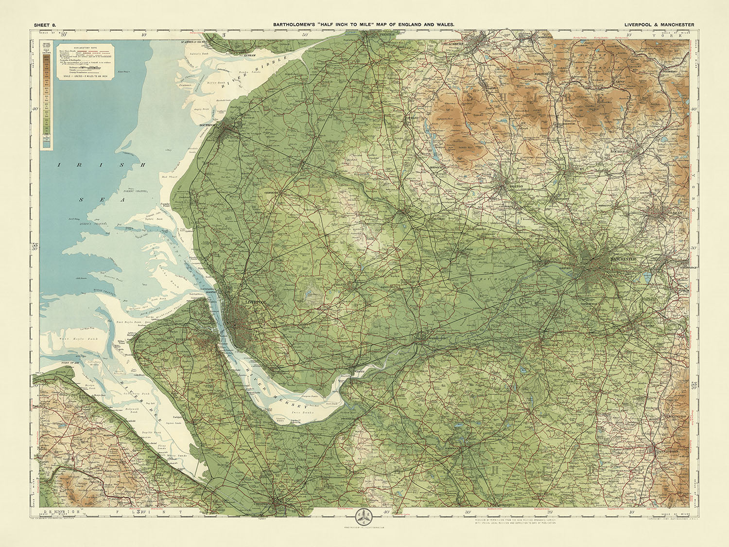
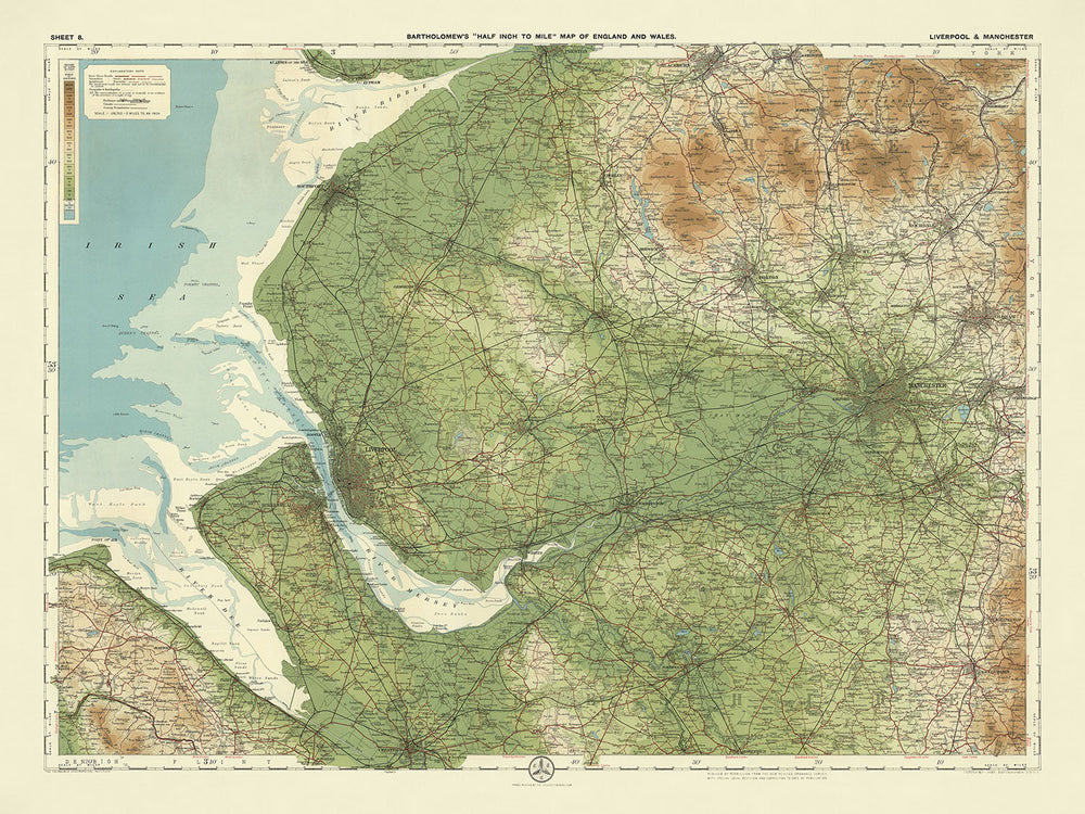
Fai un passo nel passato con l'esclusivo "Foglio 8 - Liverpool & Manchester," una creazione magistrale del rinomato cartografo JG Bartholomew nel 1901. Questa mappa, parte della serie di punta di Bartholomew, offre uno sguardo affascinante nel paesaggio dell'Inghilterra dei primi del XX secolo, dettagliando meticolosamente le regioni attorno a Liverpool e Manchester. Conosciuto per la sua precisione e finezza estetica, il lavoro di Bartholomew è una testimonianza dell'età d'oro della cartografia, dove ogni mappa non era solo uno strumento di navigazione ma anche un'opera d'arte.
Il design della mappa è sia funzionale che bello, impiegando una scala di mezzo pollice per miglio (1:126.720) che era particolarmente popolare tra ciclisti e turisti dell'epoca. Ciò che distingue questa mappa è il suo uso innovativo della gradazione di colore per rappresentare il rilievo del paesaggio, una tecnica che fornisce una rappresentazione sottile ma chiara delle diverse altezze del terreno. Questo metodo, basato su una mappa dell'Ordnance Survey ridotta, mostra l'impegno di Bartholomew per l'accuratezza e l'appeal visivo, rendendola un possesso prezioso per ogni appassionato di mappe.
Esplorando la mappa, si possono tracciare la rete intricata di fiumi, incluso l'iconico fiume Mersey, il fiume Weaver e il fiume Dee, ognuno dei quali si snoda attraverso la lussureggiante campagna. Il Manchester Ship Canal e il Bridgewater Canal sono anche in evidenza, evidenziando il patrimonio industriale della regione. L'estesa rete ferroviaria, disegnata meticolosamente, sottolinea la rapida industrializzazione e connettività dei primi anni 1900, offrendo un'istantanea di un periodo trasformativo nella storia britannica.
La copertura della mappa si estende attraverso vari contea, tra cui Lancashire, Cheshire, Derbyshire e Greater Manchester, ognuno punteggiato da città e paesi che sono cresciuti ed evoluti nel corso dell'ultimo secolo. Dai porti affollati di Liverpool al cuore industriale di Manchester, e ai paesaggi sereni delle Pennine Hills e del Peak District, questa mappa cattura una regione diversificata e dinamica. Parchi notevoli come Sefton Park e Stanley Park a Liverpool, e Birkenhead Park, aggiungono un tocco di verde all'espansione urbana, riflettendo l'equilibrio tra natura e sviluppo.
Storicamente significativa, questa mappa non solo funge da guida geografica ma anche da artefatto culturale, offrendo spunti sul paesaggio socio-economico dell'Inghilterra dei primi del XX secolo. La rappresentazione dettagliata delle aree industriali, dei porti e delle rotte di trasporto fornisce una finestra nel passato, illustrando il ruolo cruciale della regione nella Rivoluzione Industriale. Possedere questa mappa è come tenere in mano un pezzo di storia, una connessione tangibile con il mondo com'era oltre un secolo fa, realizzata da uno dei cartografi più stimati del suo tempo.
Città e paesi su questa mappa
Lancashire
- Liverpool
- Manchester
- St Helens
- Southport
- Wigan
- Bolton
- Bury
- Burnley
- Blackburn
- Preston
- Oldham
- Rochdale
- Salford
- Stockport
- Warrington
- Widnes
- Chorley
- Leigh
- Heywood
- Accrington
- Rawtenstall
- Darwen
- Ormskirk
- Skelmersdale
- Lytham St Annes
- Fleetwood
- Colne
- Nelson
- Clitheroe
Cheshire
- Chester
- Crewe
- Macclesfield
- Northwich
- Winsford
- Congleton
- Nantwich
- Runcorn
- Ellesmere Port
- Wilmslow
Derbyshire
- Glossop
- Buxton
- New Mills
- Whaley Bridge
Greater Manchester
- Ashton-under-Lyne
- Altrincham
- Sale
- Hyde
- Denton
- Stretford
- Urmston
- Eccles
- Swinton
- Radcliffe
- Middleton
- Chadderton
Caratteristiche e luoghi notevoli
- Fiumi:
- Fiume Mersey
- Fiume Weaver
- Fiume Dee
- Fiume Bollin
- Canali:
- Canale di Manchester
- Canale di Bridgewater
- Ferrovie:
- Una rete ferroviaria estesa che collega varie città e paesi.
- Parchi:
- Parco di Sefton
- Parco di Stanley
- Parco di Birkenhead
- Colline e altitudini:
- Colline Pennine
- Peak District (parzialmente visibile)
- Corpi idrici:
- Mar d'Irlanda
- Estuario del Mersey
- Vari piccoli laghi e bacini
- Strade:
- Strade principali che collegano Liverpool e Manchester
- Caratteristiche industriali:
- Porti a Liverpool
- Aree industriali intorno a Manchester
Contesto storico e di design
- Nome della mappa: Foglio 8 - Liverpool & Manchester
- Scala e design:
- Una mappa chiara, attraente e colorata in scala mezzo pollice per miglio (1:126,720).
- Popolare tra ciclisti e turisti, è diventata la serie di punta di Bartholomew.
- Distintiva per l'uso di diversi strati di colore per rappresentare il rilievo del paesaggio, con una gradazione sottile e innovativa di bande di colore per mostrare il terreno a diverse altezze.
- Basata su una mappa dell'Ordnance Survey ridotta dello stesso periodo.
- Data di creazione: 1901
- Creatore/Editore: JG Bartholomew
- Contesto interessante: JG Bartholomew, un rinomato cartografo scozzese, è stato strumentale nel far progredire l'arte della cartografia alla fine del XIX e all'inizio del XX secolo. Le sue mappe erano conosciute per la loro precisione e attrattiva estetica.
- Temi e argomenti mostrati sulla mappa:
- Caratteristiche politiche e fisiche dettagliate.
- Enfasi sul rilievo del paesaggio e sulla topografia.
- Copertura delle infrastrutture, comprese strade e ferrovie.
- Paesi e regioni mostrati sulla mappa:
- La mappa copre parti dell'Inghilterra, specificamente le regioni intorno a Liverpool e Manchester.
- Contesto di design o stile:
- La mappa è progettata in un formato paesaggistico e copre un'area di 36 miglia da nord a sud e 52 miglia da ovest a est.
- L'uso della gradazione di colore per rappresentare diverse altitudini era innovativo per il suo tempo.
- Significato storico:
- Riflette le tecniche cartografiche del primo XX secolo e l'importanza di una mappatura dettagliata per ciclisti e turisti.
- Fornisce un'idea dell'infrastruttura e del paesaggio delle regioni di Liverpool e Manchester durante i primi anni 1900.
Si prega di controllare attentamente le immagini per assicurarsi che una specifica città o luogo sia mostrato su questa mappa. Puoi anche contattarci e chiedere di controllare la mappa per te.
Questa mappa appare fantastica in ogni dimensione, ma consiglio sempre di optare per una dimensione più grande se hai spazio. In questo modo puoi facilmente distinguere tutti i dettagli.
Questa mappa sembra incredibile in dimensioni fino a 70in (180cm). Se stai cercando una mappa più grande, per favore contattaci.
Si prega di notare: le etichette su questa mappa sono difficili da leggere se ordini una mappa che è 20in (50cm) o più piccola. La mappa è comunque molto attraente, ma se desideri leggere facilmente la mappa, ti preghiamo di acquistare una dimensione più grande.
Il modello nelle immagini dell'inserzione sta tenendo la versione 18x24in (45x60cm) di questa mappa.
La quinta immagine dell'inserzione mostra un esempio del mio servizio di personalizzazione della mappa.
Se stai cercando qualcosa di leggermente diverso, dai un'occhiata alla mia collezione delle migliori mappe antiche per vedere se qualcosa attira la tua attenzione.
Si prega di contattarmi per verificare se una certa posizione, un punto di riferimento o una caratteristica è mostrata su questa mappa.
Questa sarebbe una meravigliosa idea regalo per un compleanno, Natale, Festa del Papà, pensionamento, anniversario o inaugurazione della casa per qualcuno delle aree coperte da questa mappa.
Questa mappa è disponibile come stampa giclée su carta opaca archiviata senza acidi, oppure puoi acquistarla incorniciata. La cornice è una semplice cornice nera che si adatta alla maggior parte degli stili. Ti preghiamo di contattarci se desideri un colore o un materiale di cornice diverso. Le mie cornici sono dotate di un acrilico (perspex/acrylite) di grado museale super chiaro, che è significativamente meno riflettente del vetro, più sicuro e arriverà sempre in perfette condizioni.
This map is also available as a float framed canvas, sometimes known as a shadow gap framed canvas or canvas floater. The map is printed on artist's cotton canvas and then stretched over a handmade box frame. We then "float" the canvas inside a wooden frame, which is available in a range of colours (black, dark brown, oak, antique gold and white). This is a wonderful way to present a map without glazing in front. See some examples of float framed canvas maps and explore the differences between my different finishes.
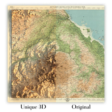
For something truly unique, this map is also available in "Unique 3D", our trademarked process that dramatically transforms the map so that it has a wonderful sense of depth. We combine the original map with detailed topography and elevation data, so that mountains and the terrain really "pop". For more info and examples of 3D maps, check my Unique 3D page.
For most orders, delivery time is about 3 working days. Personalised and customised products take longer, as I have to do the personalisation and send it to you for approval, which usually takes 1 or 2 days.
Please note that very large framed orders usually take longer to make and deliver.
If you need your order to arrive by a certain date, please contact me before you order so that we can find the best way of making sure you get your order in time.
I print and frame maps and artwork in 23 countries around the world. This means your order will be made locally, which cuts down on delivery time and ensures that it won't be damaged during delivery. You'll never pay customs or import duty, and we'll put less CO2 into the air.
All of my maps and art prints are well packaged and sent in a rugged tube if unframed, or surrounded by foam if framed.
I try to send out all orders within 1 or 2 days of receiving your order, though some products (like face masks, mugs and tote bags) can take longer to make.
If you select Express Delivery at checkout your order we will prioritise your order and send it out by 1-day courier (Fedex, DHL, UPS, Parcelforce).
Next Day delivery is also available in some countries (US, UK, Singapore, UAE) but please try to order early in the day so that we can get it sent out on time.
My standard frame is a gallery style black ash hardwood frame. It is simple and quite modern looking. My standard frame is around 20mm (0.8in) wide.
I use super-clear acrylic (perspex/acrylite) for the frame glass. It's lighter and safer than glass - and it looks better, as the reflectivity is lower.
Six standard frame colours are available for free (black, dark brown, dark grey, oak, white and antique gold). Custom framing and mounting/matting is available if you're looking for something else.
Most maps, art and illustrations are also available as a framed canvas. We use matte (not shiny) cotton canvas, stretch it over a sustainably sourced box wood frame, and then 'float' the piece within a wood frame. The end result is quite beautiful, and there's no glazing to get in the way.
All frames are provided "ready to hang", with either a string or brackets on the back. Very large frames will have heavy duty hanging plates and/or a mounting baton. If you have any questions, please get in touch.
See some examples of my framed maps and framed canvas maps.
Alternatively, I can also supply old maps and artwork on canvas, foam board, cotton rag and other materials.
If you want to frame your map or artwork yourself, please read my size guide first.
Alcune delle mie vecchie mappe sono ora disponibili come tele incorniciate. Per favore contattami se desideri ordinare una dimensione che non è disponibile nel mio negozio.
Le vecchie mappe su tela sono un'alternativa interessante alle mappe incorniciate in modo convenzionale. A seconda del tuo gusto personale e dell'arredamento della stanza, le mappe su tela possono "risaltare" un po' di più rispetto a una mappa incorniciata.
My maps are extremely high quality reproductions of original maps.
I source original, rare maps from libraries, auction houses and private collections around the world, restore them at my London workshop, and then use specialist giclée inks and printers to create beautiful maps that look even better than the original.
My maps are printed on acid-free archival matte (not glossy) paper that feels very high quality and almost like card. In technical terms the paper weight/thickness is 10mil/200gsm. It's perfect for framing.
I print with Epson ultrachrome giclée UV fade resistant pigment inks - some of the best inks you can find.
I can also make maps on canvas, cotton rag and other exotic materials.
Learn more about The Unique Maps Co.
Map personalisation
If you're looking for the perfect anniversary or housewarming gift, I can personalise your map to make it truly unique. For example, I can add a short message, or highlight an important location, or add your family's coat of arms.
The options are almost infinite. Please see my map personalisation page for some wonderful examples of what's possible.
To order a personalised map, select "personalise your map" before adding it to your basket.
Get in touch if you're looking for more complex customisations and personalisations.
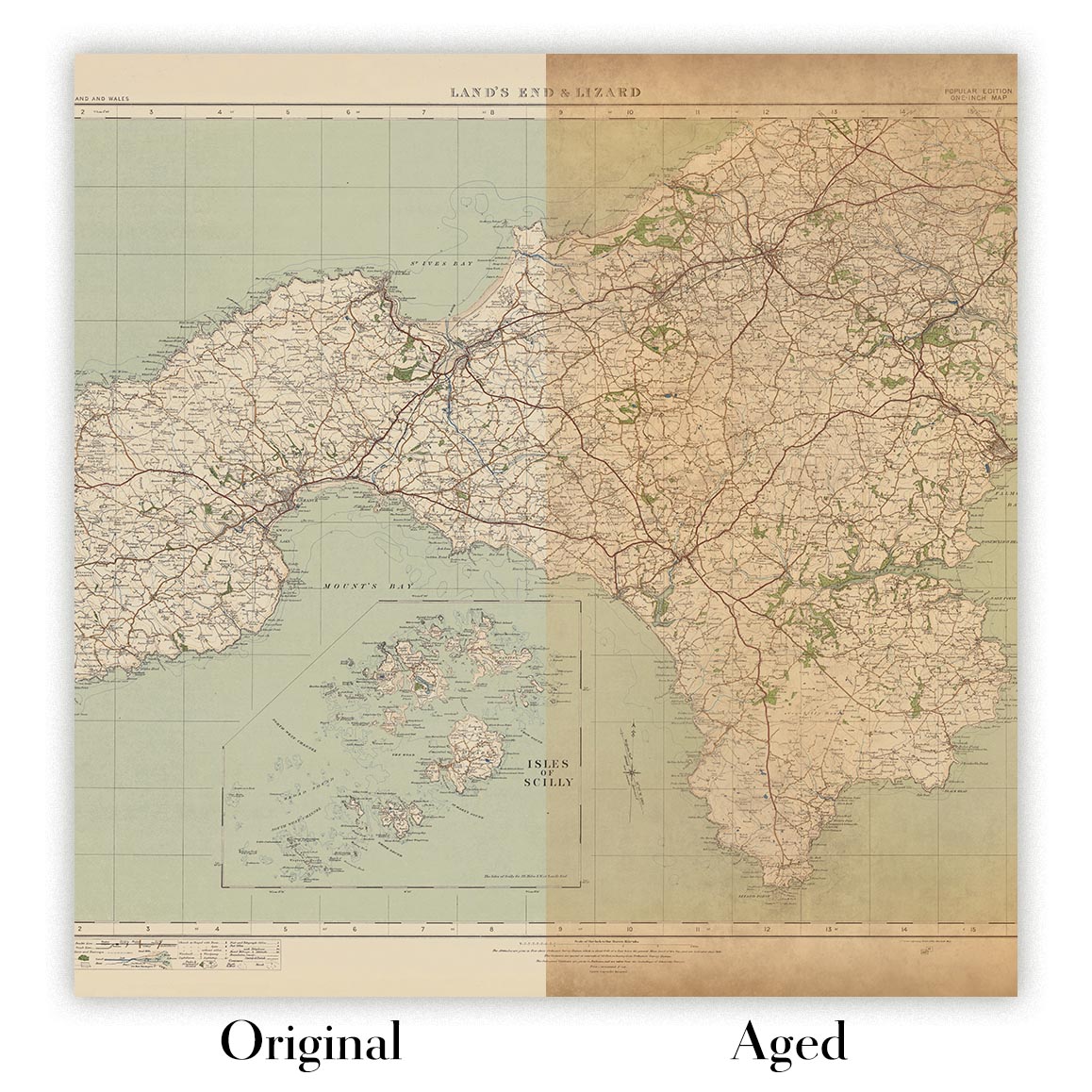
Map ageing
I have been asked hundreds of times over the years by customers if they could buy a map that looks even older.
Well, now you can, by selecting Aged before you add a map to your basket.
All the product photos you see on this page show the map in its Original form. This is what the map looks like today.
If you select Aged, I will age your map by hand, using a special and unique process developed through years of studying old maps, talking to researchers to understand the chemistry of aging paper, and of course... lots of practice!
If you're unsure, stick to the Original colour of the map. If you want something a bit darker and older looking, go for Aged.
Se non sei soddisfatto del tuo ordine per qualsiasi motivo, contattami per un rimborso senza problemi. Si prega di consultare la nostra politica di reso e rimborso per ulteriori informazioni.
Sono molto sicuro che ti piacerà la tua mappa restaurata o la stampa d'arte. Lo faccio dal 1984. Sono un venditore Etsy a 5 stelle. Ho venduto decine di migliaia di mappe e stampe d'arte e ho oltre 5.000 recensioni reali a 5 stelle.
Utilizzo un processo unico per restaurare mappe e opere d'arte che richiede molto tempo e lavoro. Trovare le mappe e le illustrazioni originali può richiedere mesi. Utilizzo tecnologia all'avanguardia e incredibilmente costosa per scannerizzare e restaurarle. Di conseguenza, garantisco che le mie mappe e stampe d'arte siano superiori alle altre - ecco perché posso offrire un rimborso senza problemi.
Quasi tutte le mie mappe e stampe d'arte sembrano fantastiche a grandi dimensioni (200 cm, 6,5 piedi+) e posso anche incorniciarle e consegnarle a te, tramite un corriere speciale per oggetti di grandi dimensioni. Contattami per discutere delle tue esigenze specifiche.
Or try searching for something!


