


Vecchia mappa pittorica del Giappone vs. Colonie delle Indie Orientali Olandesi durante la Seconda Guerra Mondiale, 1940
- All taxes and duties included
- Handmade & dispatched in 1-2 days
-
90 day money back guarantee
ⓘ
90 giorni per restituire e ricevere un rimborso
I prodotti possono essere restituiti entro 90 giorni per un rimborso completo, o cambio con un altro prodotto.
Per articoli personalizzati e su misura, potremmo offrirti un credito in negozio o una carta regalo non scadente, poiché non possiamo rivendere ordini personalizzati.
Se hai domande, contattaci. Per ulteriori informazioni, consulta la nostra politica di restituzione e cambio.

My maps are rare, museum-grade, restored old maps sourced from libraries, auction houses and private collections across the globe.
Framing & free personalisation available
1. Select your size
2. Frame & personalise your map
There is limited framing & personalisation capacity available. Order by 10am tomorrow for Christmas delivery.


Gift message & custom finish

If you want to add a gift message, or a finish (jigsaw, aluminium board, etc.) that is not available here, please request it in the "order note" when you check out.
Every order is custom made, so if you need the size adjusted slightly, or printed on an unusual material, just let us know. We've done thousands of custom orders over the years, so there's (almost) nothing we can't manage.
You can also contact us before you order, if you prefer!

- Handmade locally. No import duty or tax
- FREE Delivery by Christmas
- Love it or your money back (90 days)
- Questions? WhatsApp me any time
Own a piece of history
5,000+ 5 star reviews


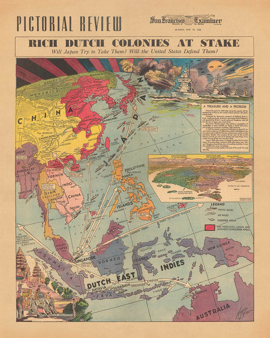
Inizia un viaggio storico con la mappa "Le Ricche Colonie Olandesi a Rischio", un vivido ritratto delle tensioni geopolitiche e degli interessi coloniali all'inizio del XX secolo. Creata da Howard Burke per il San Francisco Examiner il 20 ottobre 1940, questa mappa è un capolavoro di cartografia pittorica, catturando un momento in cui il mondo era sull'orlo di un conflitto diffuso. Come il giornale più antico pubblicato continuamente a San Francisco, l'Examiner forniva ai suoi lettori un'analisi perspicace attraverso una narrazione visiva così coinvolgente. Questa mappa, in particolare, funge da finestra sulle complessità dell'epoca, illustrando l'importanza strategica delle Indie Orientali Olandesi e la minaccia imminente dell'espansione giapponese.
Il design e lo stile di questa mappa sono tanto informativi quanto visivamente accattivanti. Adottando un approccio tematico, l'opera di Burke è una mappa pittorica a colori che non solo evidenzia i territori ma li arricchisce anche con illustrazioni vignettistiche, come elefanti e templi, che evocano l'essenza culturale e geografica delle regioni rappresentate. Un'inserzione con vista a volo d'uccello di Singapore sottolinea la sua importanza strategica, mentre le aree sotto il controllo giapponese sono contrassegnate in rosso, offrendo una comprensione chiara e immediata del panorama geopolitico. Questa mappa va oltre la mera geografia, fornendo una narrazione attraverso il suo design.
Il contenuto tematico della mappa è ricco e sfaccettato, affrontando questioni critiche come l'invasione giapponese dell'Indocina Francese, la difesa delle colonie olandesi da parte dell'America e le risorse ricche delle Indie Orientali Olandesi. Questi argomenti non sono solo note storiche; sono i fili che tessono il tessuto delle tensioni globali di questo periodo. La mappa illustra abilmente i potenziali conflitti tra Giappone e Stati Uniti, accennando alle implicazioni più ampie per le dinamiche di potere globali. Attraverso la sua dettagliata rappresentazione di simboli militari e nazionali, inclusi soldati di varie nazioni e navi da guerra, la mappa offre una visione sintetica delle relazioni internazionali dell'epoca.
La creazione di Howard Burke non è solo una mappa ma un documento storico che cattura l'essenza di un momento cruciale nella storia mondiale. Le sue illustrazioni dettagliate e annotazioni forniscono intuizioni sugli interessi militari, economici e culturali del tempo. Dalla rappresentazione delle risorse naturali come le piantagioni di gomma e le miniere alla rappresentazione strategica delle risorse militari, la mappa funge da guida completa per comprendere l'interazione complessa delle forze nella regione Asia-Pacifico. È una testimonianza dell'abilità del cartografo nel trasmettere intricate narrazioni geopolitiche attraverso l'arte della cartografia.
Per gli appassionati di storia, cartografia o dell'arte di raccontare storie attraverso le mappe, "Le Ricche Colonie Olandesi a Rischio" è più di un semplice oggetto da collezione. È un pezzo di storia, una narrazione catturata in colori e linee, che offre spunti sulle sfide e le strategie delle nazioni coinvolte nel turbine dell'ambizione e del conflitto globale. Questa mappa non è solo una rappresentazione visiva; è un portale verso il passato, invitando gli spettatori a esplorare le profondità dell'intrigo storico e l'arte della creazione di mappe.
Paesi e regioni su questa mappa
- Australia
- Borneo
- Birmania
- Cambogia
- Cina
- Indie Orientali Olandesi
- Indocina Francese
- India
- Giappone
- Giava
- Malaya
- Manchuria
- Mongolia
- Nuova Guinea
- Borneo Settentrionale
- Oceano Pacifico
- Filippine
- Russia
- Sarawak
- Siam
- Singapore
- Mar Cinese Meridionale
- Sumatra
- Vietnam
Contesto storico e di design
- Nome: Colonie olandesi ricche in gioco
- Data: 20 ottobre 1940
- Cartografo/Editore: Howard Burke, San Francisco Examiner
- Contesto: Il San Francisco Examiner è un quotidiano pubblicato a San Francisco, California. È stato fondato nel 1865 ed è il giornale pubblicato ininterrottamente più antico della città.
- Argomenti/Temi: Colonie olandesi ricche in gioco, invasione giapponese dell'Indocina francese, ruolo dell'America nella difesa delle colonie olandesi, importanza strategica di Singapore, risorse delle Indie Orientali Olandesi, potenziale conflitto tra Giappone e Stati Uniti
- Design/Stile: Mappa pittorica, Colore, Illustrazione vignetta, Mappa in dettaglio, Vista a volo d'uccello, Rilievo mostrato pittoricamente
- Significato storico/Contesto: La mappa è stata creata in un momento in cui il Giappone stava espandendo il suo impero nel Pacifico, mostrando l'importanza strategica delle Indie Orientali Olandesi e il potenziale conflitto tra Giappone e Stati Uniti.
Si prega di controllare attentamente le immagini per assicurarsi che una specifica città o luogo sia mostrato su questa mappa. Puoi anche metterti in contatto e chiedere di controllare la mappa per te.
Questa mappa appare fantastica in ogni dimensione, ma consiglio sempre di optare per una dimensione più grande se hai spazio. In questo modo puoi facilmente distinguere tutti i dettagli.
Questa mappa appare incredibile in dimensioni fino a 70in (180cm). Se stai cercando una mappa più grande, per favore contattaci.
Il modello nelle immagini dell'elenco tiene la versione 16x20in (40x50cm) di questa mappa.
La quinta immagine dell'elenco mostra un esempio del mio servizio di personalizzazione della mappa.
Se stai cercando qualcosa di leggermente diverso, dai un'occhiata alla mia collezione dei migliori mappe antiche per vedere se qualcosa attira la tua attenzione.
Per favore contattami per controllare se una certa posizione, un punto di riferimento o una caratteristica è mostrata su questa mappa.
Questa sarebbe una meravigliosa idea regalo per un compleanno, Natale, Festa del Papà, partenza dal lavoro, anniversario o festa di inaugurazione per qualcuno delle aree coperte da questa mappa.
Questa mappa è disponibile come stampa giclée su carta opaca archiviata senza acidi, oppure puoi acquistarla incorniciata. La cornice è una bella cornice nera semplice che si adatta alla maggior parte degli stili. Si prega di contattare se desideri un colore o un materiale diverso per la cornice. Le mie cornici sono dotate di un vetro acrilico (perspex/acrylite) super chiaro di grado museale, che è significativamente meno riflettente del vetro, più sicuro e arriverà sempre in perfette condizioni.
This map is also available as a float framed canvas, sometimes known as a shadow gap framed canvas or canvas floater. The map is printed on artist's cotton canvas and then stretched over a handmade box frame. We then "float" the canvas inside a wooden frame, which is available in a range of colours (black, dark brown, oak, antique gold and white). This is a wonderful way to present a map without glazing in front. See some examples of float framed canvas maps and explore the differences between my different finishes.
For something truly unique, this map is also available in "Unique 3D", our trademarked process that dramatically transforms the map so that it has a wonderful sense of depth. We combine the original map with detailed topography and elevation data, so that mountains and the terrain really "pop". For more info and examples of 3D maps, check my Unique 3D page.
For most orders, delivery time is about 3 working days. Personalised and customised products take longer, as I have to do the personalisation and send it to you for approval, which usually takes 1 or 2 days.
Please note that very large framed orders usually take longer to make and deliver.
If you need your order to arrive by a certain date, please contact me before you order so that we can find the best way of making sure you get your order in time.
I print and frame maps and artwork in 23 countries around the world. This means your order will be made locally, which cuts down on delivery time and ensures that it won't be damaged during delivery. You'll never pay customs or import duty, and we'll put less CO2 into the air.
All of my maps and art prints are well packaged and sent in a rugged tube if unframed, or surrounded by foam if framed.
I try to send out all orders within 1 or 2 days of receiving your order, though some products (like face masks, mugs and tote bags) can take longer to make.
If you select Express Delivery at checkout your order we will prioritise your order and send it out by 1-day courier (Fedex, DHL, UPS, Parcelforce).
Next Day delivery is also available in some countries (US, UK, Singapore, UAE) but please try to order early in the day so that we can get it sent out on time.
My standard frame is a gallery style black ash hardwood frame. It is simple and quite modern looking. My standard frame is around 20mm (0.8in) wide.
I use super-clear acrylic (perspex/acrylite) for the frame glass. It's lighter and safer than glass - and it looks better, as the reflectivity is lower.
Six standard frame colours are available for free (black, dark brown, dark grey, oak, white and antique gold). Custom framing and mounting/matting is available if you're looking for something else.
Most maps, art and illustrations are also available as a framed canvas. We use matte (not shiny) cotton canvas, stretch it over a sustainably sourced box wood frame, and then 'float' the piece within a wood frame. The end result is quite beautiful, and there's no glazing to get in the way.
All frames are provided "ready to hang", with either a string or brackets on the back. Very large frames will have heavy duty hanging plates and/or a mounting baton. If you have any questions, please get in touch.
See some examples of my framed maps and framed canvas maps.
Alternatively, I can also supply old maps and artwork on canvas, foam board, cotton rag and other materials.
If you want to frame your map or artwork yourself, please read my size guide first.
Alcune delle mie vecchie mappe sono ora disponibili come tele incorniciate. Per favore contattami se desideri ordinare una dimensione che non è disponibile nel mio negozio.
Le vecchie mappe su tela sono un'alternativa interessante alle mappe incorniciate in modo convenzionale. A seconda del tuo gusto personale e dell'arredamento della stanza, le mappe su tela possono "risaltare" un po' di più rispetto a una mappa incorniciata.
My maps are extremely high quality reproductions of original maps.
I source original, rare maps from libraries, auction houses and private collections around the world, restore them at my London workshop, and then use specialist giclée inks and printers to create beautiful maps that look even better than the original.
My maps are printed on acid-free archival matte (not glossy) paper that feels very high quality and almost like card. In technical terms the paper weight/thickness is 10mil/200gsm. It's perfect for framing.
I print with Epson ultrachrome giclée UV fade resistant pigment inks - some of the best inks you can find.
I can also make maps on canvas, cotton rag and other exotic materials.
Learn more about The Unique Maps Co.
Map personalisation
If you're looking for the perfect anniversary or housewarming gift, I can personalise your map to make it truly unique. For example, I can add a short message, or highlight an important location, or add your family's coat of arms.
The options are almost infinite. Please see my map personalisation page for some wonderful examples of what's possible.
To order a personalised map, select "personalise your map" before adding it to your basket.
Get in touch if you're looking for more complex customisations and personalisations.
Map ageing
I have been asked hundreds of times over the years by customers if they could buy a map that looks even older.
Well, now you can, by selecting Aged before you add a map to your basket.
All the product photos you see on this page show the map in its Original form. This is what the map looks like today.
If you select Aged, I will age your map by hand, using a special and unique process developed through years of studying old maps, talking to researchers to understand the chemistry of aging paper, and of course... lots of practice!
If you're unsure, stick to the Original colour of the map. If you want something a bit darker and older looking, go for Aged.
Se non sei soddisfatto del tuo ordine per qualsiasi motivo, contattami per un rimborso senza problemi. Si prega di consultare la nostra politica di reso e rimborso per ulteriori informazioni.
Sono molto sicuro che ti piacerà la tua mappa restaurata o la stampa d'arte. Lo faccio dal 1984. Sono un venditore Etsy a 5 stelle. Ho venduto decine di migliaia di mappe e stampe d'arte e ho oltre 5.000 recensioni reali a 5 stelle.
Utilizzo un processo unico per restaurare mappe e opere d'arte che richiede molto tempo e lavoro. Trovare le mappe e le illustrazioni originali può richiedere mesi. Utilizzo tecnologia all'avanguardia e incredibilmente costosa per scannerizzare e restaurarle. Di conseguenza, garantisco che le mie mappe e stampe d'arte siano superiori alle altre - ecco perché posso offrire un rimborso senza problemi.
Quasi tutte le mie mappe e stampe d'arte sembrano fantastiche a grandi dimensioni (200 cm, 6,5 piedi+) e posso anche incorniciarle e consegnarle a te, tramite un corriere speciale per oggetti di grandi dimensioni. Contattami per discutere delle tue esigenze specifiche.
Or try searching for something!


