


Mappa antica di Denver di Thayer, 1883: Fiume Platte, Cherry Creek, City Park, Edificio dell'Esposizione, Windsor Hotel
Compra 2, Ricevi 1 Gratuito
Se aggiungi 2 articoli al tuo carrello, puoi aggiungere un terzo prodotto gratuitamente.
Questo vale per tutte le mappe e opere d'arte, comprese le opere personalizzate e su misura. Puoi ordinare 3 dello stesso articolo, o 3 articoli diversi.
Questo equivale a uno sconto del 33%, che sarà il maggiore sconto disponibile nel mio negozio quest'anno.
Ti prego di approfittare dell'offerta e di coprire le tue pareti con bellissime mappe e opere d'arte!
Contattami se hai domande.
- All taxes and duties included
- Handmade & dispatched in 1-2 days
-
FREE gift preview
ⓘ
Digital gift preview
After you complete your order, you can send a beautiful digital preview to the gift recipient. Just provide their email address and we'll do the rest. (Their email address will not be stored or used for any other purpose.)
This is perfect if you're concerned that your order might not arrive in time.
You can also buy a real non-expiring gift card, and email it directly to the recipient, so they can buy their own map or artwork.
-
90 day money back guarantee
ⓘ
90 giorni per restituire e ricevere un rimborso
I prodotti possono essere restituiti entro 90 giorni per un rimborso completo, o cambio con un altro prodotto.
Per articoli personalizzati e su misura, potremmo offrirti un credito in negozio o una carta regalo non scadente, poiché non possiamo rivendere ordini personalizzati.
Se hai domande, contattaci. Per ulteriori informazioni, consulta la nostra politica di restituzione e cambio.

My maps are rare, museum-grade, restored old maps sourced from libraries, auction houses and private collections across the globe.
Framing & free personalisation available
1. Select your size
Click here to order a custom size.
2. Frame & personalise your map
Make your map unique with framing, hand-drawn customisation, vintage ageing, pop art text, unique 3D styling and more.


Gift message & custom finish

If you want to add a gift message, or a finish (jigsaw, aluminium board, etc.) that is not available here, please request it in the "order note" when you check out.
Every order is custom made, so if you need the size adjusted slightly, or printed on an unusual material, just let us know. We've done thousands of custom orders over the years, so there's (almost) nothing we can't manage.
You can also contact us before you order, if you prefer!

- Handmade locally. No import duty or tax
- FREE worldwide delivery
- Love it or your money back (90 days)
- Questions? WhatsApp me any time
Own a piece of history
5,000+ 5 star reviews


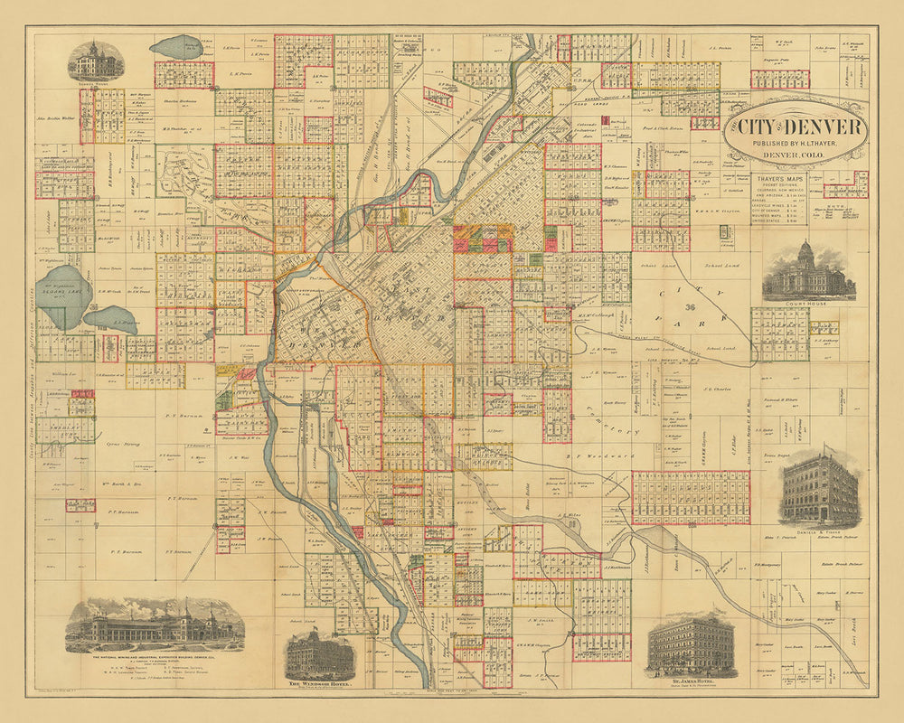
La mappa della "Città di Denver", pubblicata da H.L. Thayer nel 1883, è uno sguardo affascinante nello sviluppo urbano di Denver durante la fine del XIX secolo. Questa rara mappa antica è centrata sul fiume Platte, dettagliando meticolosamente le strade della città, i proprietari terrieri e le suddivisioni. L'inclusione di importanti punti di riferimento come i terreni della Denver and New Orleans RR Company e il Canale Irrigante della Platte Water Company evidenzia i progressi infrastrutturali dell'epoca. Questa mappa non solo funge da strumento di navigazione, ma anche da documento storico, catturando l'essenza della crescita e trasformazione di Denver.
Una delle caratteristiche più sorprendenti di questa mappa è la sua dettagliata rappresentazione di East Denver, che mostra la posizione di numerosi edifici e i terreni della Denver and New Orleans Railroad Company proprio oltre Cherry Creek a West Denver. La mappa offre uno sguardo affascinante sulla pianificazione urbana e sulla distribuzione delle terre, fornendo spunti sull'espansione della città e sul ruolo fondamentale della ferrovia nel suo sviluppo. La documentazione accurata dei nomi dei proprietari terrieri e delle suddivisioni aggiunge un tocco personale, collegando lo spettatore agli individui che hanno plasmato il paesaggio iniziale di Denver.
La mappa è ulteriormente abbellita con sei vignette illustrate, ciascuna rappresentante un punto di riferimento significativo dell'epoca. Queste includono l'Edificio dell'Esposizione Nazionale Mineraria e Industriale, che aprì il 1° agosto 1882, il Windsor Hotel, lo St. James Hotel, l'Edificio Daniels & Fisher, il Palazzo di Giustizia e la Scuola. Queste illustrazioni non solo migliorano l'appeal estetico della mappa, ma forniscono anche una narrazione visiva del patrimonio architettonico di Denver. Ogni vignetta funge da finestra sul passato, offrendo uno sguardo sulle strutture prominenti della città e sui loro ruoli nella comunità.
City Park, etichettato come Lotto 36, è un'altra caratteristica notevole su questa mappa. La rappresentazione del Canale Irrigante della Platte Water Company che scorre attraverso il parco evidenzia l'importanza della gestione dell'acqua e degli spazi verdi nella pianificazione della città. Questo primo accento sulla creazione di un ambiente urbano equilibrato con ampie aree ricreative riflette la lungimiranza dei pianificatori di Denver e il loro impegno per migliorare la qualità della vita dei suoi residenti. La presenza di grandi parchi e caratteristiche naturali sottolinea la dedizione della città alla preservazione della sua bellezza naturale in mezzo alla rapida urbanizzazione.
La maestria e l'attenzione ai dettagli di H.L. Thayer sono evidenti in tutta questa mappa. La sua capacità di catturare l'intricata disposizione di Denver, insieme ai suoi punti di riferimento significativi e alle infrastrutture, rende questa mappa un prezioso artefatto storico. La mappa della "Città di Denver" non è solo uno strumento di navigazione, ma un ricco arazzo della storia della città, offrendo una prospettiva unica sulla sua crescita e sviluppo. Per i collezionisti e gli appassionati di storia, questa mappa è un tesoro di informazioni e una testimonianza del passato vibrante di Denver.
Strade e vie su questa mappa
- Strada Arapahoe
- Strada Blake
- Broadway
- Strada Champa
- Strada Cherokee
- Luogo Cheyenne
- Viale Colfax
- Strada Curtis
- Strada Delgany
- Strada Diciottesima
- Ottava Avenue
- Strada Undicesima
- Strada Quindicesima
- Strada Quattordicesima
- Strada Fox
- Viale Grant
- Strada Larimer
- Strada Lawrence
- Viale Lincoln
- Strada Mariposa
- Strada Market
- Strada Platte
- Sesta Avenue
- Strada Stout
- Luogo Tremont
- Via Dodicesima
- Via Walnut
- Via Welton
- Via Wewatta
- Via Wynkoop
Caratteristiche e Monumenti Notabili
- Illustrazioni:
- Edificio della National Mining and Industrial Exposition
- Hotel Windsor
- Hotel St. James
- Edificio Daniels & Fisher
- Tribunale
-
Scuola
-
Monumenti:
- Fiume Platte
-
Ruscello Cherry
-
Quartieri:
- East Denver
-
West Denver
-
Grandi Parchi:
-
City Park (Lotto 36)
-
Altre Caratteristiche Notabili:
- Terreni della Denver and New Orleans RR Company
- Canale di irrigazione della Platte Water Company
Contesto Storico e di Design
- Nome della mappa: La Città di Denver
- Editore: H.L. Thayer
- Data di creazione: 1883
- Tipo: Mappa stradale della città
- Mappa rara di Denver: Mappa altamente dettagliata della città di Denver.
- Centro della mappa: Centrata sul fiume Platte.
- Proprietà terriera: Include i nomi di decine di proprietari terrieri, suddivisioni e altri dettagli.
- East Denver: Mostra la posizione di numerosi edifici e i terreni della Denver and New Orleans RR Company appena oltre il ruscello Cherry a West Denver.
- Platte Water Company: Il canale di irrigazione della Platte Water Company è mostrato che scorre attraverso il City Park (Lotto 36) nella parte orientale della città.
- Vignette illustrate: Abbellita con 6 vignette illustrate:
- Edificio della National Mining and Industrial Exposition (aperto il 1 agosto 1882)
- Hotel Windsor
- Hotel St. James
- Edificio Daniels & Fisher
- Tribunale
- Scuola
- Significato storico: Fornisce un'istantanea dello sviluppo urbano e delle infrastrutture di Denver alla fine del XIX secolo.
Si prega di controllare attentamente le immagini per assicurarsi che una specifica città o luogo sia mostrato su questa mappa. Puoi anche contattarci e chiedere di controllare la mappa per te.
Questa mappa appare fantastica in ogni dimensione, ma consiglio sempre di optare per una dimensione più grande se hai spazio. In questo modo puoi facilmente distinguere tutti i dettagli.
Questa mappa appare incredibile in dimensioni fino a 100in (250cm). Se stai cercando una mappa più grande, per favore contattaci.
Si prega di notare: le etichette su questa mappa sono difficili da leggere se ordini una mappa che è 36in (90cm) o più piccola. La mappa è comunque molto attraente, ma se desideri leggere facilmente la mappa, ti preghiamo di acquistare una dimensione più grande.
Il modello nelle immagini dell'elenco tiene in mano la versione 16x20in (40x50cm) di questa mappa.
La quinta immagine dell'elenco mostra un esempio del mio servizio di personalizzazione della mappa.
Se stai cercando qualcosa di leggermente diverso, dai un'occhiata alla mia collezione delle migliori mappe antiche per vedere se qualcosa attira la tua attenzione.
Per favore contattami per controllare se una certa posizione, monumento o caratteristica è mostrata su questa mappa.
Questo sarebbe un meraviglioso regalo per un compleanno, Natale, Festa del Papà, partenza dal lavoro, anniversario o inaugurazione della casa per qualcuno delle aree coperte da questa mappa.
Questa mappa è disponibile come stampa giclée su carta opaca archiviabile senza acidi, oppure puoi acquistarla incorniciata. La cornice è una bella e semplice cornice nera che si adatta alla maggior parte degli stili. Ti preghiamo di contattarci se desideri un colore o un materiale diverso per la cornice. Le mie cornici sono dotate di un vetro acrilico super chiaro di qualità museale (perspex/acrylite), che è significativamente meno riflettente del vetro, più sicuro e arriverà sempre in perfette condizioni.
This map is also available as a float framed canvas, sometimes known as a shadow gap framed canvas or canvas floater. The map is printed on artist's cotton canvas and then stretched over a handmade box frame. We then "float" the canvas inside a wooden frame, which is available in a range of colours (black, dark brown, oak, antique gold and white). This is a wonderful way to present a map without glazing in front. See some examples of float framed canvas maps and explore the differences between my different finishes.
For something truly unique, this map is also available in "Unique 3D", our trademarked process that dramatically transforms the map so that it has a wonderful sense of depth. We combine the original map with detailed topography and elevation data, so that mountains and the terrain really "pop". For more info and examples of 3D maps, check my Unique 3D page.
For most orders, delivery time is about 3 working days. Personalised and customised products take longer, as I have to do the personalisation and send it to you for approval, which usually takes 1 or 2 days.
Please note that very large framed orders usually take longer to make and deliver.
If you need your order to arrive by a certain date, please contact me before you order so that we can find the best way of making sure you get your order in time.
I print and frame maps and artwork in 23 countries around the world. This means your order will be made locally, which cuts down on delivery time and ensures that it won't be damaged during delivery. You'll never pay customs or import duty, and we'll put less CO2 into the air.
All of my maps and art prints are well packaged and sent in a rugged tube if unframed, or surrounded by foam if framed.
I try to send out all orders within 1 or 2 days of receiving your order, though some products (like face masks, mugs and tote bags) can take longer to make.
If you select Express Delivery at checkout your order we will prioritise your order and send it out by 1-day courier (Fedex, DHL, UPS, Parcelforce).
Next Day delivery is also available in some countries (US, UK, Singapore, UAE) but please try to order early in the day so that we can get it sent out on time.
My standard frame is a gallery style black ash hardwood frame. It is simple and quite modern looking. My standard frame is around 20mm (0.8in) wide.
I use super-clear acrylic (perspex/acrylite) for the frame glass. It's lighter and safer than glass - and it looks better, as the reflectivity is lower.
Six standard frame colours are available for free (black, dark brown, dark grey, oak, white and antique gold). Custom framing and mounting/matting is available if you're looking for something else.
Most maps, art and illustrations are also available as a framed canvas. We use matte (not shiny) cotton canvas, stretch it over a sustainably sourced box wood frame, and then 'float' the piece within a wood frame. The end result is quite beautiful, and there's no glazing to get in the way.
All frames are provided "ready to hang", with either a string or brackets on the back. Very large frames will have heavy duty hanging plates and/or a mounting baton. If you have any questions, please get in touch.
See some examples of my framed maps and framed canvas maps.
Alternatively, I can also supply old maps and artwork on canvas, foam board, cotton rag and other materials.
If you want to frame your map or artwork yourself, please read my size guide first.
Alcune delle mie vecchie mappe sono ora disponibili come tele incorniciate. Per favore contattami se desideri ordinare una dimensione che non è disponibile nel mio negozio.
Le vecchie mappe su tela sono un'alternativa interessante alle mappe incorniciate in modo convenzionale. A seconda del tuo gusto personale e dell'arredamento della stanza, le mappe su tela possono "risaltare" un po' di più rispetto a una mappa incorniciata.
My maps are extremely high quality reproductions of original maps.
I source original, rare maps from libraries, auction houses and private collections around the world, restore them at my London workshop, and then use specialist giclée inks and printers to create beautiful maps that look even better than the original.
My maps are printed on acid-free archival matte (not glossy) paper that feels very high quality and almost like card. In technical terms the paper weight/thickness is 10mil/200gsm. It's perfect for framing.
I print with Epson ultrachrome giclée UV fade resistant pigment inks - some of the best inks you can find.
I can also make maps on canvas, cotton rag and other exotic materials.
Learn more about The Unique Maps Co.
Map personalisation
If you're looking for the perfect anniversary or housewarming gift, I can personalise your map to make it truly unique. For example, I can add a short message, or highlight an important location, or add your family's coat of arms.
The options are almost infinite. Please see my map personalisation page for some wonderful examples of what's possible.
To order a personalised map, select "personalise your map" before adding it to your basket.
Get in touch if you're looking for more complex customisations and personalisations.
Map ageing
I have been asked hundreds of times over the years by customers if they could buy a map that looks even older.
Well, now you can, by selecting Aged before you add a map to your basket.
All the product photos you see on this page show the map in its Original form. This is what the map looks like today.
If you select Aged, I will age your map by hand, using a special and unique process developed through years of studying old maps, talking to researchers to understand the chemistry of aging paper, and of course... lots of practice!
If you're unsure, stick to the Original colour of the map. If you want something a bit darker and older looking, go for Aged.
Se non sei soddisfatto del tuo ordine per qualsiasi motivo, contattami per un rimborso senza problemi. Si prega di consultare la nostra politica di reso e rimborso per ulteriori informazioni.
Sono molto sicuro che ti piacerà la tua mappa restaurata o la stampa d'arte. Lo faccio dal 1984. Sono un venditore Etsy a 5 stelle. Ho venduto decine di migliaia di mappe e stampe d'arte e ho oltre 5.000 recensioni reali a 5 stelle.
Utilizzo un processo unico per restaurare mappe e opere d'arte che richiede molto tempo e lavoro. Trovare le mappe e le illustrazioni originali può richiedere mesi. Utilizzo tecnologia all'avanguardia e incredibilmente costosa per scannerizzare e restaurarle. Di conseguenza, garantisco che le mie mappe e stampe d'arte siano superiori alle altre - ecco perché posso offrire un rimborso senza problemi.
Quasi tutte le mie mappe e stampe d'arte sembrano fantastiche a grandi dimensioni (200 cm, 6,5 piedi+) e posso anche incorniciarle e consegnarle a te, tramite un corriere speciale per oggetti di grandi dimensioni. Contattami per discutere delle tue esigenze specifiche.
Or try searching for something!


