


Prima mappa del New England di John Smith, 1616: Boston, Plymouth, Cape Ann, design barocco ornato
- All taxes and duties included
- Handmade & dispatched in 1-2 days
-
90 day money back guarantee
ⓘ
90 giorni per restituire e ricevere un rimborso
I prodotti possono essere restituiti entro 90 giorni per un rimborso completo, o cambio con un altro prodotto.
Per articoli personalizzati e su misura, potremmo offrirti un credito in negozio o una carta regalo non scadente, poiché non possiamo rivendere ordini personalizzati.
Se hai domande, contattaci. Per ulteriori informazioni, consulta la nostra politica di restituzione e cambio.

My maps are rare, museum-grade, restored old maps sourced from libraries, auction houses and private collections across the globe.
Framing & free personalisation available
1. Select your size
2. Frame & personalise your map
There is limited framing & personalisation capacity available. Order by 10am tomorrow for Christmas delivery.


Gift message & custom finish

If you want to add a gift message, or a finish (jigsaw, aluminium board, etc.) that is not available here, please request it in the "order note" when you check out.
Every order is custom made, so if you need the size adjusted slightly, or printed on an unusual material, just let us know. We've done thousands of custom orders over the years, so there's (almost) nothing we can't manage.
You can also contact us before you order, if you prefer!

- Handmade locally. No import duty or tax
- FREE Delivery by Christmas
- Love it or your money back (90 days)
- Questions? WhatsApp me any time
Own a piece of history
5,000+ 5 star reviews


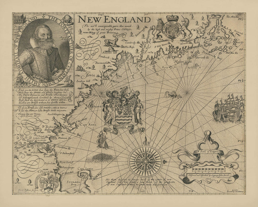
Entra nell'alba della cartografia americana con "New England Le parti più remarquabili così denominate dal potente Principe Carlo, ora Re della grande Britannia. Osservato e descritto dal Capitano John Smith." Creato nel 1616, questa mappa è ampiamente considerata la fondazione della cartografia del New England e la prima a dedicarsi interamente a questa storica regione. È qui, attraverso la mano attenta e l'occhio acuto del Capitano John Smith, che il nome stesso "New England" è stato conferito, alterando per sempre il paesaggio geografico e culturale del continente. Il titolo originale della mappa, un testamento al patrocinio e all'ambizione reale, segnala la sua posizione unica all'incrocio tra esplorazione, politica e arte.
Il Capitano John Smith, famoso per le sue precedenti imprese in Virginia, fu incaricato da mercanti londinesi di esplorare la misteriosa costa settentrionale oltre le colonie stabilite. Insoddisfatto dell'inaffidabilità delle carte esistenti, Smith intraprese il proprio rilievo, mappando meticolosamente la costa, i fiumi e i promontori. La sua dedizione alla precisione è evidente in ogni dettaglio, dalla delineazione attenta della frastagliata costa del New England alla posizione prominente dei principali fiumi come il Charles. Il lavoro risultante non solo fornì una guida pratica per futuri esploratori e coloni, ma servì anche come un invito persuasivo all'investimento e alla colonizzazione inglese.
L'arte della mappa è tanto notevole quanto la sua precisione cartografica. Incisa da Simon de Passe, un maestro artista olandese che lavorava a Londra, la mappa è adornata con una serie di elementi decorativi che riflettono la grandezza dell'era barocca. Un ritratto impressionante di John Smith ancorà la composizione, mentre l'ornata "scala delle leghe" e la complessa rosa dei venti mostrano l'uso innovativo dello stile auricolare da parte di de Passe, un primo marchio del design barocco. Gli Stemmi del Consiglio per il New England, con il loro motto latino "GENS INCOGNITA MIHI SERVIET," aggiungono un tocco di autorità e ambizione all'espansione costiera.
Questa mappa cattura un momento cruciale nella storia, quando la corona inglese—attraverso l'influenza del Principe Carlo, poi Re Carlo I—impose nuovi nomi e identità sul paesaggio americano. Alcuni di questi nomi, tra cui Cape Anne, Charles River e Plymouth, perdurano fino ad oggi, segnando l'eredità duratura del lavoro di Smith. La posizione attenta di Boston e la prima apparizione di Charlestown riflettono il suo ruolo nel plasmare la geografia urbana della regione, mentre la sua evocativa rappresentazione di baie, isole e fiumi suggerisce la bellezza selvaggia che attendeva i primi coloni.
Oltre ai suoi successi tecnici e artistici, la mappa di Smith rimane un simbolo di ambizione, curiosità e spirito di scoperta. È un legame tangibile con i primi giorni dell'America inglese—un'epoca in cui i confini del mondo erano ancora in fase di tracciamento, e ogni curva di fiume o promontorio costiero conteneva la promessa di nuovi inizi. Per collezionisti, storici e amanti dell'esplorazione, questa mappa non è solo un artefatto; è un invito a tornare alle stesse origini del New England.
Città e paesi su questa mappa
- Boston
- Charlestown
- Plymouth
Caratteristiche e luoghi notevoli
- Gli Stemmi del Consiglio per il New England con il motto latino "GENS INCOGNITA MIHI SERVIET" al largo della costa di Cape Anna
- Una grande rosa dei venti ornata
- Un cartiglio decorativo con il titolo e la dedica della mappa
- Ritratto del Capitano John Smith con la data "Ao 1616"
- La "scala delle leghe" con elaborata decorazione auricolare barocca
- Fiumi principali, incluso il fiume Charles
- Cape Anne (ora Cape Ann)
- La costa del New England, inclusi golfi, promontori e isole
- Una nota sotto la rosa dei venti: "Colui che desidera sapere di più sullo stato del New England legga un nuovo libro della prospettiva del New England e lì troverà soddisfazione"
Contesto storico e di design
- Creato nel 1616 dal Capitano John Smith, famoso esploratore e cartografo
- Inciso da Simon de Passe, un rinomato incisore olandese che lavorava a Londra
- La prima mappa dedicata esclusivamente alla regione del New England e considerata la base della cartografia del New England
- Introdusse il nome "New England" e incluse nomi di luoghi forniti da Charles, Principe di Galles (in seguito Carlo I)
- Corretto errori di mappatura precedenti e stabilito un nuovo standard di accuratezza nella regione
- Presenta elementi decorativi barocchi, inclusi i primi esempi dello stile auricolare
- Pubblicata con il libro di Smith A Description of New England nel giugno 1616
- Giocò un ruolo chiave nella promozione della colonizzazione inglese e degli investimenti nel New England
Si prega di controllare attentamente le immagini per assicurarsi che una specifica città o luogo sia mostrato su questa mappa. Puoi anche contattarci e chiedere di controllare la mappa per te.
Questa mappa appare fantastica in ogni dimensione, ma consiglio sempre di optare per una dimensione più grande se hai spazio. In questo modo puoi facilmente distinguere tutti i dettagli.
Questa mappa appare incredibile in dimensioni fino a 50in (125cm). Se stai cercando una mappa più grande, per favore contattaci.
Il modello nelle immagini dell'elenco tiene la versione di questa mappa 16x20in (40x50cm).
La quinta immagine dell'elenco mostra un esempio del mio servizio di personalizzazione della mappa.
Se stai cercando qualcosa di leggermente diverso, dai un'occhiata alla mia collezione delle migliori vecchie mappe per vedere se qualcosa attira la tua attenzione.
Per favore contattami per controllare se una certa posizione, un punto di riferimento o una caratteristica è mostrata su questa mappa.
Questo sarebbe un meraviglioso regalo per un compleanno, Natale, Festa del Papà, partenza dal lavoro, anniversario o inaugurazione della casa per qualcuno delle aree coperte da questa mappa.
Questa mappa è disponibile come stampa giclée su carta opaca archiviabile senza acidi, oppure puoi acquistarla incorniciata. La cornice è una semplice cornice nera che si adatta alla maggior parte degli stili. Si prega di contattare se si desidera un colore o un materiale di cornice diverso. Le mie cornici sono vetriate con acrilico museum-grade super chiaro (perspex/acrylite), che è significativamente meno riflettente del vetro, più sicuro e arriverà sempre in perfette condizioni.
This map is also available as a float framed canvas, sometimes known as a shadow gap framed canvas or canvas floater. The map is printed on artist's cotton canvas and then stretched over a handmade box frame. We then "float" the canvas inside a wooden frame, which is available in a range of colours (black, dark brown, oak, antique gold and white). This is a wonderful way to present a map without glazing in front. See some examples of float framed canvas maps and explore the differences between my different finishes.
For something truly unique, this map is also available in "Unique 3D", our trademarked process that dramatically transforms the map so that it has a wonderful sense of depth. We combine the original map with detailed topography and elevation data, so that mountains and the terrain really "pop". For more info and examples of 3D maps, check my Unique 3D page.
For most orders, delivery time is about 3 working days. Personalised and customised products take longer, as I have to do the personalisation and send it to you for approval, which usually takes 1 or 2 days.
Please note that very large framed orders usually take longer to make and deliver.
If you need your order to arrive by a certain date, please contact me before you order so that we can find the best way of making sure you get your order in time.
I print and frame maps and artwork in 23 countries around the world. This means your order will be made locally, which cuts down on delivery time and ensures that it won't be damaged during delivery. You'll never pay customs or import duty, and we'll put less CO2 into the air.
All of my maps and art prints are well packaged and sent in a rugged tube if unframed, or surrounded by foam if framed.
I try to send out all orders within 1 or 2 days of receiving your order, though some products (like face masks, mugs and tote bags) can take longer to make.
If you select Express Delivery at checkout your order we will prioritise your order and send it out by 1-day courier (Fedex, DHL, UPS, Parcelforce).
Next Day delivery is also available in some countries (US, UK, Singapore, UAE) but please try to order early in the day so that we can get it sent out on time.
My standard frame is a gallery style black ash hardwood frame. It is simple and quite modern looking. My standard frame is around 20mm (0.8in) wide.
I use super-clear acrylic (perspex/acrylite) for the frame glass. It's lighter and safer than glass - and it looks better, as the reflectivity is lower.
Six standard frame colours are available for free (black, dark brown, dark grey, oak, white and antique gold). Custom framing and mounting/matting is available if you're looking for something else.
Most maps, art and illustrations are also available as a framed canvas. We use matte (not shiny) cotton canvas, stretch it over a sustainably sourced box wood frame, and then 'float' the piece within a wood frame. The end result is quite beautiful, and there's no glazing to get in the way.
All frames are provided "ready to hang", with either a string or brackets on the back. Very large frames will have heavy duty hanging plates and/or a mounting baton. If you have any questions, please get in touch.
See some examples of my framed maps and framed canvas maps.
Alternatively, I can also supply old maps and artwork on canvas, foam board, cotton rag and other materials.
If you want to frame your map or artwork yourself, please read my size guide first.
Alcune delle mie vecchie mappe sono ora disponibili come tele incorniciate. Per favore contattami se desideri ordinare una dimensione che non è disponibile nel mio negozio.
Le vecchie mappe su tela sono un'alternativa interessante alle mappe incorniciate in modo convenzionale. A seconda del tuo gusto personale e dell'arredamento della stanza, le mappe su tela possono "risaltare" un po' di più rispetto a una mappa incorniciata.
My maps are extremely high quality reproductions of original maps.
I source original, rare maps from libraries, auction houses and private collections around the world, restore them at my London workshop, and then use specialist giclée inks and printers to create beautiful maps that look even better than the original.
My maps are printed on acid-free archival matte (not glossy) paper that feels very high quality and almost like card. In technical terms the paper weight/thickness is 10mil/200gsm. It's perfect for framing.
I print with Epson ultrachrome giclée UV fade resistant pigment inks - some of the best inks you can find.
I can also make maps on canvas, cotton rag and other exotic materials.
Learn more about The Unique Maps Co.
Map personalisation
If you're looking for the perfect anniversary or housewarming gift, I can personalise your map to make it truly unique. For example, I can add a short message, or highlight an important location, or add your family's coat of arms.
The options are almost infinite. Please see my map personalisation page for some wonderful examples of what's possible.
To order a personalised map, select "personalise your map" before adding it to your basket.
Get in touch if you're looking for more complex customisations and personalisations.
Map ageing
I have been asked hundreds of times over the years by customers if they could buy a map that looks even older.
Well, now you can, by selecting Aged before you add a map to your basket.
All the product photos you see on this page show the map in its Original form. This is what the map looks like today.
If you select Aged, I will age your map by hand, using a special and unique process developed through years of studying old maps, talking to researchers to understand the chemistry of aging paper, and of course... lots of practice!
If you're unsure, stick to the Original colour of the map. If you want something a bit darker and older looking, go for Aged.
Se non sei soddisfatto del tuo ordine per qualsiasi motivo, contattami per un rimborso senza problemi. Si prega di consultare la nostra politica di reso e rimborso per ulteriori informazioni.
Sono molto sicuro che ti piacerà la tua mappa restaurata o la stampa d'arte. Lo faccio dal 1984. Sono un venditore Etsy a 5 stelle. Ho venduto decine di migliaia di mappe e stampe d'arte e ho oltre 5.000 recensioni reali a 5 stelle.
Utilizzo un processo unico per restaurare mappe e opere d'arte che richiede molto tempo e lavoro. Trovare le mappe e le illustrazioni originali può richiedere mesi. Utilizzo tecnologia all'avanguardia e incredibilmente costosa per scannerizzare e restaurarle. Di conseguenza, garantisco che le mie mappe e stampe d'arte siano superiori alle altre - ecco perché posso offrire un rimborso senza problemi.
Quasi tutte le mie mappe e stampe d'arte sembrano fantastiche a grandi dimensioni (200 cm, 6,5 piedi+) e posso anche incorniciarle e consegnarle a te, tramite un corriere speciale per oggetti di grandi dimensioni. Contattami per discutere delle tue esigenze specifiche.
Or try searching for something!


