


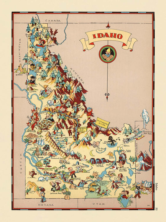


Mappa pittorica dell'Idaho di Ruth Taylor White, 1935: Boise, Fiume Snake, Miniere, Silvicoltura, Agricoltura, Confini delle contee
Compra 2, Ricevi 1 Gratuito
Se aggiungi 2 articoli al tuo carrello, puoi aggiungere un terzo prodotto gratuitamente.
Questo vale per tutte le mappe e opere d'arte, comprese le opere personalizzate e su misura. Puoi ordinare 3 dello stesso articolo, o 3 articoli diversi.
Questo equivale a uno sconto del 33%, che sarà il maggiore sconto disponibile nel mio negozio quest'anno.
Ti prego di approfittare dell'offerta e di coprire le tue pareti con bellissime mappe e opere d'arte!
Contattami se hai domande.
- All taxes and duties included
- Handmade & dispatched in 1-2 days
-
Complimentary gifting & design advice
ⓘ
Complimentary gifting & design advice
Available almost 24/7 on WhatsApp and email — we usually reply within minutes. We can help you:
- Choose a perfectly personalised gift
- Send a digital gift preview to the recipient
- Pick the ideal size for your wall
- Select the right finish and frame
Quick, friendly advice so you can order with confidence.
For last minute gifts, consider buying a digital gift card. We have over 5,000 maps and art prints to choose from.
-
90-day returns & 5-year guarantee
ⓘ
90 giorni per restituire e ricevere un rimborso
I prodotti possono essere restituiti entro 90 giorni per un rimborso completo, o cambio con un altro prodotto.
Per articoli personalizzati e su misura, potremmo offrirti un credito in negozio o una carta regalo non scadente, poiché non possiamo rivendere ordini personalizzati.
Se hai domande, contattaci. Per ulteriori informazioni, consulta la nostra politica di restituzione e cambio.

This is a museum-grade archival print from the original 1935 map — restored in our workshop and made to order on 220gsm archival matte paper or 400gsm artist's cotton canvas with pigment inks.
Professional framing & free personalisation available
1. Select your size
Click here to order a custom size.
2. Frame & personalise your map
Make your map unique with framing, hand-drawn customisation, vintage ageing, pop art text, unique 3D styling and more.


Gift message & custom finish

If you want to add a gift message, or a finish (jigsaw, aluminium board, etc.) that is not available here, please request it in the "order note" when you check out.
Every order is custom made, so if you need the size adjusted slightly, or printed on an unusual material, just let us know. We've done thousands of custom orders over the years, so there's (almost) nothing we can't manage.
You can also contact us before you order, if you prefer!

- Handmade locally. No import duty or tax
- FREE worldwide delivery
- 90-day returns & 5-year product guarantee
- Questions? WhatsApp me any time
Own a piece of history
7,000+ 5 star reviews


Entra nel vibrante mondo della cartografia americana degli anni '30 con "Idaho", una mappa pictoriale fantasiosa realizzata dalla celebre illustratrice Ruth Taylor White nel 1935. Con il suo titolo originale semplicemente come "Idaho", questa mappa è una narrativa visiva affascinante che riflette sia il carattere unico che le percezioni culturali dello Stato Gem durante l'inizio del ventesimo secolo. La mappa fa parte di una serie distintiva di atlanti pictoriali che hanno deliziato e informato il pubblico con la loro arte giocosa e il orgoglio regionale, invitando gli spettatori a vivere il paesaggio e l'identità dell'Idaho attraverso una lente di esagerazione colorata e fascino storico.
Lo stile distintivo di Ruth Taylor White è immediatamente evidente nella palette vivace e nelle illustrazioni animate e simili a fumetti di questa mappa. Il suo approccio fonde la precisione della cartografia tradizionale con il flair narrativo di un'artista, risultando in un pezzo che è tanto informativo quanto incantevole. I confini e i nomi delle contee sono resi con chiarezza, mentre il confine dello stato è delineato in modo audace, incorniciando un arazzo delle caratteristiche distintive dell'Idaho. Ogni angolo della mappa è vivo di riferimenti visivi alle industrie locali, alle tradizioni e alle meraviglie naturali, rendendola una vera celebrazione del luogo.
La ricchezza tematica della mappa si rivela attraverso le sue deliziose rappresentazioni della vita economica e culturale dell'Idaho. Vignette pictoriali mostrano il famoso raccolto agricolo dello stato - patate, grano e bestiame - insieme a scene dinamiche di estrazione mineraria e silvicoltura, industrie che hanno plasmato lo sviluppo dell'Idaho e continuano a definire il suo patrimonio. Figure vivaci di minatori, boscaioli e agricoltori si mescolano con immagini di attività ricreative come lo sci e la pesca, riflettendo sia la ruggedness che l'appeal ricreativo della regione. Figure e motivi culturali dei nativi americani sono integrati con attenzione, offrendo un cenno alle radici storiche più profonde dello stato.
La bellezza naturale è un tema centrale, con le illustrazioni della mappa di montagne, fiumi e fauna selvatica che catturano la grandezza e la diversità del paesaggio dell'Idaho. Il leggendario fiume Snake si snoda attraverso lo stato, il cui corso è segnato da immagini giocose di pesci e uccelli acquatici. Catene montuose esagerate, foreste lussureggianti e cervi erranti evocano lo spirito indomito della terra, mentre l'assenza di parchi nazionali specificamente etichettati o luoghi storici consente all'arazzo panoramico e culturale più ampio di prendere il centro della scena. Questo approccio artistico rende la mappa sia un tesoro decorativo che un affascinante documento storico.
La mappa è ulteriormente arricchita dalla sua etichettatura dettagliata delle città e dei paesi dell'Idaho, dalla capitale Boise a comunità più piccole come Grangeville, Salmon e Wallace. Ogni insediamento è posizionato con cura, offrendo uno sguardo sulla geografia umana dello stato così come si presentava negli anni '30. Che tu sia attratto dai vivaci paesaggi urbani o dalle tranquille distese rurali, questa mappa fornisce una finestra unica nel passato dell'Idaho, rendendola un'aggiunta eccezionale a qualsiasi collezione di mappe storiche o Americana. "Idaho" di Ruth Taylor White è più di una mappa - è un omaggio vivace e artistico a uno straordinario stato americano.
Città e paesi su questa mappa
- Boise
- Idaho Falls
- Pocatello
- Twin Falls
- Caldwell
- Lewiston
- Moscow
- Nampa
- Blackfoot
- Burley
- Coeur d’Alene
- Payette
- Weiser
- Mountain Home
- Rupert
- Gooding
- Salmon
- Grangeville
- Sandpoint
- Wallace
Caratteristiche e monumenti notevoli
- I confini e i nomi delle contee sono chiaramente riportati in tutto l'Idaho.
- I principali fiumi come il fiume Snake sono illustrati e etichettati.
- Rappresentazioni pittoriche dell'agricoltura, tra cui patate, grano e bestiame.
- Illustrazioni dell'attività mineraria, come minatori e attrezzature minerarie.
- Rappresentazioni della silvicoltura e del disboscamento, tra cui boscaioli e legname.
- Attività ricreative, come sci e pesca, sono illustrate.
- Illustrazioni di figure dei nativi americani e riferimenti culturali.
- Fauna iconica, come cervi e pesci, è mostrata.
- Montagne e paesaggi scenici sono rappresentati con un'evidente esagerazione artistica.
- Il confine statale dell'Idaho è chiaramente delineato.
- La mappa include disegni fantasiosi in stile cartone animato che evidenziano il carattere unico dell'Idaho.
Contesto storico e di design
- Nome della mappa: Idaho (come titolato sulla mappa).
- Cartografa: Ruth Taylor White, un'illustratrice nota per le sue mappe pittoriche fantasiose e colorate, spesso in collaborazione con suo marito, Frank J. Taylor, negli anni '30.
- Data di creazione: 1935.
- Tipo di mappa: Mappa tematica e pittorica delle contee o degli stati.
- Stile artistico: Presenta illustrazioni vivaci, in stile cartone animato, con rappresentazioni esagerate e giocose della cultura locale, dell'economia e del paesaggio.
- Temi: La mappa evidenzia scene e caratteristiche stereotipate associate all'Idaho negli anni '30, come agricoltura, mineraria, silvicoltura e ricreazione.
- Contesto culturale: Le illustrazioni riflettono gli elementi culturali e il contesto storico dell'Idaho all'inizio del XX secolo, fornendo un'idea di come lo stato fosse percepito all'epoca.
- Regioniche mostrate: L'intero stato dell'Idaho, con confini e nomi delle contee chiaramente contrassegnati.
- Significato storico: Serve come narrazione visiva e artefatto culturale, catturando l'identità, l'economia e il fascino dell'Idaho negli anni '30 attraverso l'arte e la cartografia.
Si prega di controllare attentamente le immagini per assicurarsi che una specifica città o luogo sia mostrato su questa mappa. È possibile anche contattarci e chiedere di controllare la mappa per voi.
Questa mappa appare fantastica in ogni dimensione, ma consiglio sempre di optare per una dimensione più grande se si ha spazio. In questo modo, è possibile distinguere facilmente tutti i dettagli.
Questa mappa appare incredibile in dimensioni fino a 50 pollici (125 cm). Se stai cercando una mappa più grande, ti preghiamo di contattarci.
Il modello nelle immagini dell'elenco tiene la versione 18x24 pollici (45x60 cm) di questa mappa.
La quinta immagine dell'elenco mostra un esempio del mio servizio di personalizzazione della mappa.
Se stai cercando qualcosa di leggermente diverso, dai un'occhiata alla mia collezione delle migliori mappe antiche per vedere se qualcosa attira la tua attenzione.
Si prega di contattarmi per verificare se una certa posizione, monumento o caratteristica è mostrata su questa mappa.
Questo sarebbe un regalo meraviglioso per un compleanno, Natale, Festa del Papà, partenza dal lavoro, anniversario o inaugurazione per qualcuno delle aree coperte da questa mappa.
Questa mappa è disponibile come stampa giclée su carta opaca archiviabile senza acidi, oppure puoi acquistarla incorniciata. La cornice è una semplice cornice nera che si adatta alla maggior parte degli stili. Ti preghiamo di contattarci se desideri un colore o un materiale della cornice diverso. Le mie cornici sono dotate di un vetro acrilico super chiaro di qualità museale (perspex/acrylite), che è significativamente meno riflettente del vetro, più sicuro e arriverà sempre in perfette condizioni.
This map is also available as a float framed canvas, sometimes known as a shadow gap framed canvas or canvas floater. The map is printed on artist's cotton canvas and then stretched over a handmade box frame. We then "float" the canvas inside a wooden frame, which is available in a range of colours (black, dark brown, oak, antique gold and white). This is a wonderful way to present a map without glazing in front. See some examples of float framed canvas maps and explore the differences between my different finishes.
For something truly unique, this map is also available in "Unique 3D", our trademarked process that dramatically transforms the map so that it has a wonderful sense of depth. We combine the original map with detailed topography and elevation data, so that mountains and the terrain really "pop". For more info and examples of 3D maps, check my Unique 3D page.
For most orders, delivery time is about 3 working days. Personalised and customised products take longer, as I have to do the personalisation and send it to you for approval, which usually takes 1 or 2 days.
Please note that very large framed orders usually take longer to make and deliver.
If you need your order to arrive by a certain date, please contact me before you order so that we can find the best way of making sure you get your order in time.
I print and frame maps and artwork in 23 countries around the world. This means your order will be made locally, which cuts down on delivery time and ensures that it won't be damaged during delivery. You'll never pay customs or import duty, and we'll put less CO2 into the air.
All of my maps and art prints are well packaged and sent in a rugged tube if unframed, or surrounded by foam if framed.
I try to send out all orders within 1 or 2 days of receiving your order, though some products (like face masks, mugs and tote bags) can take longer to make.
If you select Express Delivery at checkout your order we will prioritise your order and send it out by 1-day courier (Fedex, DHL, UPS, Parcelforce).
Next Day delivery is also available in some countries (US, UK, Singapore, UAE) but please try to order early in the day so that we can get it sent out on time.
My standard frame is a gallery style black ash hardwood frame. It is simple and quite modern looking. My standard frame is around 20mm (0.8in) wide.
I use super-clear acrylic (perspex/acrylite) for the frame glass. It's lighter and safer than glass - and it looks better, as the reflectivity is lower.
Six standard frame colours are available for free (black, dark brown, dark grey, oak, white and antique gold). Custom framing and mounting/matting is available if you're looking for something else.
Most maps, art and illustrations are also available as a framed canvas. We use matte (not shiny) cotton canvas, stretch it over a sustainably sourced box wood frame, and then 'float' the piece within a wood frame. The end result is quite beautiful, and there's no glazing to get in the way.
All frames are provided "ready to hang", with either a string or brackets on the back. Very large frames will have heavy duty hanging plates and/or a mounting baton. If you have any questions, please get in touch.
See some examples of my framed maps and framed canvas maps.
Alternatively, I can also supply old maps and artwork on canvas, foam board, cotton rag and other materials.
If you want to frame your map or artwork yourself, please read my size guide first.
Alcune delle mie vecchie mappe sono ora disponibili come tele incorniciate. Per favore contattami se desideri ordinare una dimensione che non è disponibile nel mio negozio.
Le vecchie mappe su tela sono un'alternativa interessante alle mappe incorniciate in modo convenzionale. A seconda del tuo gusto personale e dell'arredamento della stanza, le mappe su tela possono "risaltare" un po' di più rispetto a una mappa incorniciata.
My maps are extremely high quality reproductions of original maps.
I source original, rare maps from libraries, auction houses and private collections around the world, restore them at my London workshop, and then use specialist giclée inks and printers to create beautiful maps that look even better than the original.
My maps are printed on acid-free archival matte (not glossy) paper that feels very high quality and almost like card. In technical terms the paper weight/thickness is 10mil/200gsm. It's perfect for framing.
I print with Epson ultrachrome giclée UV fade resistant pigment inks - some of the best inks you can find.
I can also make maps on canvas, cotton rag and other exotic materials.
Learn more about The Unique Maps Co.
Map personalisation
If you're looking for the perfect anniversary or housewarming gift, I can personalise your map to make it truly unique. For example, I can add a short message, or highlight an important location, or add your family's coat of arms.
The options are almost infinite. Please see my map personalisation page for some wonderful examples of what's possible.
To order a personalised map, select "personalise your map" before adding it to your basket.
Get in touch if you're looking for more complex customisations and personalisations.
Map ageing
I have been asked hundreds of times over the years by customers if they could buy a map that looks even older.
Well, now you can, by selecting Aged before you add a map to your basket.
All the product photos you see on this page show the map in its Original form. This is what the map looks like today.
If you select Aged, I will age your map by hand, using a special and unique process developed through years of studying old maps, talking to researchers to understand the chemistry of aging paper, and of course... lots of practice!
If you're unsure, stick to the Original colour of the map. If you want something a bit darker and older looking, go for Aged.
Se non sei soddisfatto del tuo ordine per qualsiasi motivo, contattami per un rimborso senza problemi. Si prega di consultare la nostra politica di reso e rimborso per ulteriori informazioni.
Sono molto sicuro che ti piacerà la tua mappa restaurata o la stampa d'arte. Lo faccio dal 1984. Sono un venditore Etsy a 5 stelle. Ho venduto decine di migliaia di mappe e stampe d'arte e ho oltre 5.000 recensioni reali a 5 stelle.
Utilizzo un processo unico per restaurare mappe e opere d'arte che richiede molto tempo e lavoro. Trovare le mappe e le illustrazioni originali può richiedere mesi. Utilizzo tecnologia all'avanguardia e incredibilmente costosa per scannerizzare e restaurarle. Di conseguenza, garantisco che le mie mappe e stampe d'arte siano superiori alle altre - ecco perché posso offrire un rimborso senza problemi.
Quasi tutte le mie mappe e stampe d'arte sembrano fantastiche a grandi dimensioni (200 cm, 6,5 piedi+) e posso anche incorniciarle e consegnarle a te, tramite un corriere speciale per oggetti di grandi dimensioni. Contattami per discutere delle tue esigenze specifiche.
Or try searching for something!


