


Antica mappa rara di Croazia e Slovenia di Münster, 1552: fiume Drava, costa adriatica, Zara, confini ottomani, montagne
Compra 2, Ricevi 1 Gratuito
Se aggiungi 2 articoli al tuo carrello, puoi aggiungere un terzo prodotto gratuitamente.
Questo vale per tutte le mappe e opere d'arte, comprese le opere personalizzate e su misura. Puoi ordinare 3 dello stesso articolo, o 3 articoli diversi.
Questo equivale a uno sconto del 33%, che sarà il maggiore sconto disponibile nel mio negozio quest'anno.
Ti prego di approfittare dell'offerta e di coprire le tue pareti con bellissime mappe e opere d'arte!
Contattami se hai domande.
- All taxes and duties included
- Handmade & dispatched in 1-2 days
-
Complimentary gifting & design advice
ⓘ
Complimentary gifting & design advice
Available almost 24/7 on WhatsApp and email — we usually reply within minutes. We can help you:
- Choose a perfectly personalised gift
- Send a digital gift preview to the recipient
- Pick the ideal size for your wall
- Select the right finish and frame
Quick, friendly advice so you can order with confidence.
For last minute gifts, consider buying a digital gift card. We have over 5,000 maps and art prints to choose from.
-
90-day returns & 5-year guarantee
ⓘ
90 giorni per restituire e ricevere un rimborso
I prodotti possono essere restituiti entro 90 giorni per un rimborso completo, o cambio con un altro prodotto.
Per articoli personalizzati e su misura, potremmo offrirti un credito in negozio o una carta regalo non scadente, poiché non possiamo rivendere ordini personalizzati.
Se hai domande, contattaci. Per ulteriori informazioni, consulta la nostra politica di restituzione e cambio.

This is a museum-grade archival print from the original 1552 map — restored in our workshop and made to order on 220gsm archival matte paper or 400gsm artist's cotton canvas with pigment inks.
Professional framing & free personalisation available.
1. Choose a size
2. Frame & personalise your map
Make your map unique with framing, hand-drawn customisation, vintage ageing, pop art text, unique 3D styling and more.


Gift message & custom finish

If you want to add a gift message, or a finish (jigsaw, aluminium board, etc.) that is not available here, please request it in the "order note" when you check out.
Every order is custom made, so if you need the size adjusted slightly, or printed on an unusual material, just let us know. We've done thousands of custom orders over the years, so there's (almost) nothing we can't manage.
You can also contact us before you order, if you prefer!

- Handmade locally. No import duty or tax
- FREE worldwide delivery
- 90-day returns & 5-year product guarantee
- Questions? WhatsApp me any time
Own a piece of history
7,000+ 5 star reviews


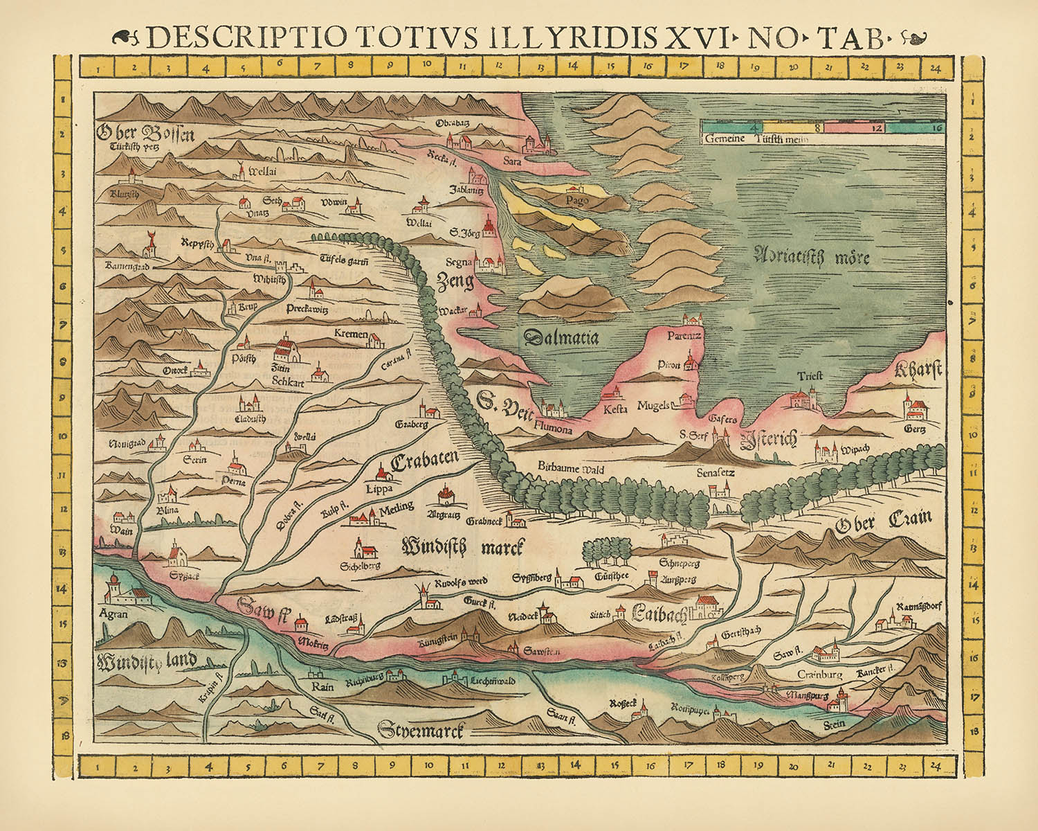
Entra nel mondo intricato della cartografia del XVI secolo con il notevole “Descriptio Totius Illyridis” di Sebastian Münster, una mappa che cattura elegantemente le terre oggi conosciute come Croazia e Slovenia. Creata nel 1552, quest'opera è una testimonianza dell'abilità e della visione straordinarie di Münster, offrendo una prospettiva orientata a sud che attira immediatamente lo spettatore nel cuore dei Balcani. Il titolo latino della mappa riflette le tradizioni accademiche del suo tempo e la sua dettagliata rappresentazione del fiume Drava e della costa adriatica invita sia all'ammirazione che all'esplorazione.
Sebastian Münster, uno dei geografi più influenti del Rinascimento, era rinomato per la sua opera magna, la “Cosmographia.” Le sue mappe erano più di semplici strumenti di navigazione: erano finestre sui mutevoli paesaggi politici e culturali dell'Europa. In questa mappa, Münster dà vita alla regione storicamente conosciuta come Illiria, un crocevia di imperi e culture. Il suo approccio meticoloso è evidente nel modo in cui delinea le caratteristiche fisiche e gli insediamenti umani, offrendo uno sguardo raro sulla geopolitica dei Balcani del XVI secolo.
Una caratteristica sorprendente di questa mappa è la sua rappresentazione simbolica dell'influenza ottomana. Le città nell'angolo in alto a sinistra sono sormontate da simboli a mezzaluna, un'indicazione sottile ma potente dell'espansione dell'Impero Ottomano nell'Europa sudorientale. Questo dettaglio non segna solo il controllo territoriale, ma funge anche da promemoria visivo della storia turbolenta dell'epoca. L'accurata annotazione di Münster di questi confini trasforma la mappa in un documento storico, cronachando il flusso e riflusso degli imperi lungo il confine tra l'Europa cristiana e il mondo ottomano.
La geografia naturale della regione è resa con il tocco di un artista. Il fiume Drava, etichettato come “Saw,” attraversa la parte inferiore della mappa, ancorando il paesaggio e guidando l'occhio verso la storica costa adriatica. Catene montuose stilizzate si ergono in un drammatico rilievo, riflettendo il terreno aspro che ha a lungo definito il carattere dei Balcani. Queste caratteristiche topografiche non sono semplicemente decorative; sono fondamentali per comprendere il significato strategico e culturale delle città e dei paesi della regione.
Tra gli insediamenti rappresentati, Zadar (etichettata “Sara”) spicca, la sua posizione costiera suggerendo secoli di commercio marittimo e scambi culturali. Sebbene la scrittura antica e i simboli stilizzati della mappa rendano difficile identificare ogni insediamento con precisione moderna, la presenza di tali città parla dell'eredità duratura di questi luoghi. La mappa di Münster, con la sua fusione di arte e studio, offre a collezionisti e storici un affascinante viaggio attraverso i paesaggi e le storie della Croazia e della Slovenia durante una delle epoche più dinamiche d'Europa.
Città e paesi su questa mappa
- Croazia:
- Zadar (Sara)
- Le città sotto controllo ottomano sono contrassegnate da simboli a mezzaluna, ma l'identificazione specifica delle città moderne non è possibile con sicurezza dall'immagine fornita.
Caratteristiche e punti di riferimento notevoli
- Fiume Drava (Saw) chiaramente etichettato e rappresentato in modo prominente
- Costiera del Mare Adriatico chiaramente visibile
- Catene montuose stilizzate rappresentate in tutta la mappa
- Simboli a mezzaluna che contrassegnano le città sotto controllo ottomano, indicando confini storici e aree di influenza ottomana
- Elementi decorativi e simboli a mezzaluna che indicano le città in mano ottomana
Contesto storico e di design
- Creato nel 1552 da Sebastian Münster, un prominente cartografo e cosmografo tedesco
- Titolo originale: Descriptio Totius Illyridis XVI No Tab (Croazia e Slovenia)
- La mappa è orientata con il sud in cima, una pratica comune nella cartografia antica prima della standardizzazione delle mappe orientate a nord
- Rappresenta principalmente le regioni della Croazia e della Slovenia, storicamente conosciute come Illiria
- Prodotta durante un periodo di espansione ottomana in Europa, come indicato dai simboli a mezzaluna che segnano le città sotto controllo ottomano
- Enfatizza la geografia fisica, i fiumi, le montagne e gli insediamenti, riflettendo lo stile cartografico del XVI secolo
- Tipica delle mappe di Münster, presenta illustrazioni dettagliate delle caratteristiche topografiche, montagne stilizzate, fiumi e rappresentazioni simboliche degli insediamenti
- Fornisce preziose informazioni sulla situazione geopolitica nei Balcani durante il XVI secolo, in particolare sull'estensione dell'influenza ottomana nella regione
Si prega di controllare attentamente le immagini per assicurarsi che una specifica città o luogo sia mostrato su questa mappa. Puoi anche contattarci e chiedere di controllare la mappa per te.
Questa mappa appare fantastica in ogni dimensione, ma consiglio sempre di optare per una dimensione più grande se hai spazio. In questo modo puoi facilmente distinguere tutti i dettagli.
Questa mappa appare incredibile in dimensioni fino a 70in (180cm). Se stai cercando una mappa più grande, ti prego di contattarci.
Il modello nelle immagini dell'inserzione tiene la versione 16x20in (40x50cm) di questa mappa.
La quinta immagine dell'inserzione mostra un esempio del mio servizio di personalizzazione della mappa.
Se stai cercando qualcosa di leggermente diverso, dai un'occhiata alla mia collezione delle migliori mappe antiche per vedere se qualcosa attira la tua attenzione.
Per favore contattami per verificare se una certa posizione, punto di riferimento o caratteristica è mostrata su questa mappa.
Questa sarebbe una meravigliosa idea regalo per un compleanno, Natale, Festa del Papà, partenza dal lavoro, anniversario o inaugurazione della casa per qualcuno delle aree coperte da questa mappa.
Questa mappa è disponibile come stampa giclée su carta opaca archiviata senza acidi, oppure puoi acquistarla incorniciata. La cornice è una semplice cornice nera che si adatta alla maggior parte degli stili. Ti prego di contattarmi se desideri un colore o materiale di cornice diverso. Le mie cornici sono dotate di un acrilico (perspex/acrylite) di grado museale super chiaro, che è significativamente meno riflettente del vetro, più sicuro e arriverà sempre in perfette condizioni.
This map is also available as a float framed canvas, sometimes known as a shadow gap framed canvas or canvas floater. The map is printed on artist's cotton canvas and then stretched over a handmade box frame. We then "float" the canvas inside a wooden frame, which is available in a range of colours (black, dark brown, oak, antique gold and white). This is a wonderful way to present a map without glazing in front. See some examples of float framed canvas maps and explore the differences between my different finishes.
For something truly unique, this map is also available in "Unique 3D", our trademarked process that dramatically transforms the map so that it has a wonderful sense of depth. We combine the original map with detailed topography and elevation data, so that mountains and the terrain really "pop". For more info and examples of 3D maps, check my Unique 3D page.
For most orders, delivery time is about 3 working days. Personalised and customised products take longer, as I have to do the personalisation and send it to you for approval, which usually takes 1 or 2 days.
Please note that very large framed orders usually take longer to make and deliver.
If you need your order to arrive by a certain date, please contact me before you order so that we can find the best way of making sure you get your order in time.
I print and frame maps and artwork in 23 countries around the world. This means your order will be made locally, which cuts down on delivery time and ensures that it won't be damaged during delivery. You'll never pay customs or import duty, and we'll put less CO2 into the air.
All of my maps and art prints are well packaged and sent in a rugged tube if unframed, or surrounded by foam if framed.
I try to send out all orders within 1 or 2 days of receiving your order, though some products (like face masks, mugs and tote bags) can take longer to make.
If you select Express Delivery at checkout your order we will prioritise your order and send it out by 1-day courier (Fedex, DHL, UPS, Parcelforce).
Next Day delivery is also available in some countries (US, UK, Singapore, UAE) but please try to order early in the day so that we can get it sent out on time.
My standard frame is a gallery style black ash hardwood frame. It is simple and quite modern looking. My standard frame is around 20mm (0.8in) wide.
I use super-clear acrylic (perspex/acrylite) for the frame glass. It's lighter and safer than glass - and it looks better, as the reflectivity is lower.
Six standard frame colours are available for free (black, dark brown, dark grey, oak, white and antique gold). Custom framing and mounting/matting is available if you're looking for something else.
Most maps, art and illustrations are also available as a framed canvas. We use matte (not shiny) cotton canvas, stretch it over a sustainably sourced box wood frame, and then 'float' the piece within a wood frame. The end result is quite beautiful, and there's no glazing to get in the way.
All frames are provided "ready to hang", with either a string or brackets on the back. Very large frames will have heavy duty hanging plates and/or a mounting baton. If you have any questions, please get in touch.
See some examples of my framed maps and framed canvas maps.
Alternatively, I can also supply old maps and artwork on canvas, foam board, cotton rag and other materials.
If you want to frame your map or artwork yourself, please read my size guide first.
Alcune delle mie vecchie mappe sono ora disponibili come tele incorniciate. Per favore contattami se desideri ordinare una dimensione che non è disponibile nel mio negozio.
Le vecchie mappe su tela sono un'alternativa interessante alle mappe incorniciate in modo convenzionale. A seconda del tuo gusto personale e dell'arredamento della stanza, le mappe su tela possono "risaltare" un po' di più rispetto a una mappa incorniciata.
My maps are extremely high quality reproductions of original maps.
I source original, rare maps from libraries, auction houses and private collections around the world, restore them at my London workshop, and then use specialist giclée inks and printers to create beautiful maps that look even better than the original.
My maps are printed on acid-free archival matte (not glossy) paper that feels very high quality and almost like card. In technical terms the paper weight/thickness is 10mil/200gsm. It's perfect for framing.
I print with Epson ultrachrome giclée UV fade resistant pigment inks - some of the best inks you can find.
I can also make maps on canvas, cotton rag and other exotic materials.
Learn more about The Unique Maps Co.
Map personalisation
If you're looking for the perfect anniversary or housewarming gift, I can personalise your map to make it truly unique. For example, I can add a short message, or highlight an important location, or add your family's coat of arms.
The options are almost infinite. Please see my map personalisation page for some wonderful examples of what's possible.
To order a personalised map, select "personalise your map" before adding it to your basket.
Get in touch if you're looking for more complex customisations and personalisations.
Map ageing
I have been asked hundreds of times over the years by customers if they could buy a map that looks even older.
Well, now you can, by selecting Aged before you add a map to your basket.
All the product photos you see on this page show the map in its Original form. This is what the map looks like today.
If you select Aged, I will age your map by hand, using a special and unique process developed through years of studying old maps, talking to researchers to understand the chemistry of aging paper, and of course... lots of practice!
If you're unsure, stick to the Original colour of the map. If you want something a bit darker and older looking, go for Aged.
Se non sei soddisfatto del tuo ordine per qualsiasi motivo, contattami per un rimborso senza problemi. Si prega di consultare la nostra politica di reso e rimborso per ulteriori informazioni.
Sono molto sicuro che ti piacerà la tua mappa restaurata o la stampa d'arte. Lo faccio dal 1984. Sono un venditore Etsy a 5 stelle. Ho venduto decine di migliaia di mappe e stampe d'arte e ho oltre 5.000 recensioni reali a 5 stelle.
Utilizzo un processo unico per restaurare mappe e opere d'arte che richiede molto tempo e lavoro. Trovare le mappe e le illustrazioni originali può richiedere mesi. Utilizzo tecnologia all'avanguardia e incredibilmente costosa per scannerizzare e restaurarle. Di conseguenza, garantisco che le mie mappe e stampe d'arte siano superiori alle altre - ecco perché posso offrire un rimborso senza problemi.
Quasi tutte le mie mappe e stampe d'arte sembrano fantastiche a grandi dimensioni (200 cm, 6,5 piedi+) e posso anche incorniciarle e consegnarle a te, tramite un corriere speciale per oggetti di grandi dimensioni. Contattami per discutere delle tue esigenze specifiche.
Or try searching for something!


