


Mappa del Mondo Antico di Al-Idrisi, 1154: Tabula Rogeriana, Arabia Centro del Mondo
20% di sconto su 2 — 33% di sconto su 3
Aggiungi qualsiasi due articoli idonei al tuo carrello per ricevere 20% di sconto. Aggiungi un terzo e sarà gratuito (equivalente a 33% di sconto quando acquisti tre).
Nessun codice necessario — l'offerta si applica automaticamente al checkout.
Valido su tutte le mappe standard e le stampe d'arte fine. Puoi mescolare e abbinare qualsiasi design.
Se desideri spedire articoli a più indirizzi, ti preghiamo di contattarci prima di effettuare il tuo ordine.
Le commissioni personalizzate e su misura sono escluse.
Contattaci se hai domande
- All taxes and duties included
- Handmade & dispatched in 1-2 days
-
Complimentary gifting & design advice
ⓘ
Complimentary gifting & design advice
Available almost 24/7 on WhatsApp and email — we usually reply within minutes. We can help you:
- Choose a perfectly personalised gift
- Send a digital gift preview to the recipient
- Pick the ideal size for your wall
- Select the right finish and frame
Quick, friendly advice so you can order with confidence.
For last minute gifts, consider buying a digital gift card. We have over 5,000 maps and art prints to choose from.
-
90-day returns & 5-year guarantee
ⓘ
90 giorni per restituire e ricevere un rimborso
I prodotti possono essere restituiti entro 90 giorni per un rimborso completo, o cambio con un altro prodotto.
Per articoli personalizzati e su misura, potremmo offrirti un credito in negozio o una carta regalo non scadente, poiché non possiamo rivendere ordini personalizzati.
Se hai domande, contattaci. Per ulteriori informazioni, consulta la nostra politica di restituzione e cambio.

This is a museum-grade archival print from the original 1154 map — restored in our workshop and made to order on 220gsm archival matte paper or 400gsm artist's cotton canvas with pigment inks.
Beautifully framed and ready to hang, with complimentary personalisation available.
Choose your size
Choose your frame


Gift message & custom finish

If you want to add a gift message, or a finish (jigsaw, aluminium board, etc.) that is not available here, please request it in the "order note" when you check out.
Every order is custom made, so if you need the size adjusted slightly, or printed on an unusual material, just let us know. We've done thousands of custom orders over the years, so there's (almost) nothing we can't manage.
You can also contact us before you order, if you prefer!

- Handmade locally. No import duty or tax
- FREE worldwide delivery
- 90-day returns & 5-year product guarantee
- Questions? WhatsApp me any time
Own a piece of history
7,000+ 5 star reviews


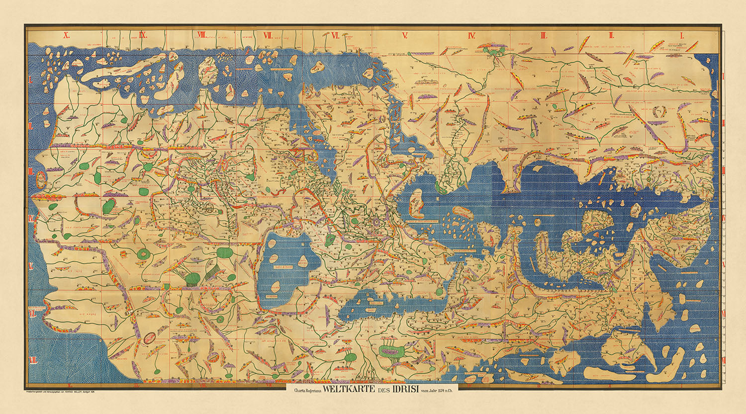
Inizia un viaggio attraverso il tempo con l'illustre Charta Rogeriana, una mappa del mondo meticolosamente realizzata dal rinomato geografo arabo, Muhammad Al-Idrisi, nell'anno 1154. Questo capolavoro, noto anche come Tabula Rogeriana, fu commissionato dal re normanno Roger II di Sicilia, racchiudendo un mondo ben oltre i confini del Mediterraneo. L'opera innovativa di Al-Idrisi, basata su ampie interviste con viaggiatori esperti e sulla sintesi di conoscenze affidabili, rappresenta un confluito di geografia, clima ed esplorazione, artisticamente rappresentato attraverso i continenti dall'Europa all'Asia, e dall'Africa all'Oceano Indiano. Questa mappa tematica, con la sua unica orientazione sud-in-alto, si estende dalle coste della Spagna all'espansione della Corea, tracciando terre sia conosciute che misteriose per la mente medievale.
Muhammad Al-Idrisi, una figura di illuminazione alla corte cosmopolita di Sicilia, intraprese questo compito monumentale, non solo come cartografo ma come cronista della diversità del mondo. Per oltre quindici anni, Al-Idrisi ha fuso la saggezza dei viaggiatori con le sue stesse intuizioni accademiche per produrre un'opera che trascendeva i confini del suo tempo. La Charta Rogeriana non è solo una mappa; è una narrativa di climi, regioni e dei popoli che le abitano, dalle vivaci città d'Europa alle remote frontiere dell'Asia e ai paesaggi variabili dell'Africa. Il suo approccio innovativo, che divideva il mondo in sette zone climatiche, riecheggia le tradizioni classiche introducendo al contempo una precisione e un dettaglio che sarebbero rimasti senza pari per secoli.
Il design e la proiezione cartografica della Charta Rogeriana sono una testimonianza della mente visionaria di Al-Idrisi. Orientando la mappa con il sud in alto, ha sfidato le percezioni convenzionali dello spazio e della direzione, ponendo la penisola arabica al centro del mondo. Questa orientazione non era solo un'affermazione geografica ma anche simbolica, evidenziando l'importanza del mondo islamico nell'era medievale. La rappresentazione dettagliata della mappa di montagne, fiumi, città e strade, insieme alle distanze tra i luoghi chiave, offre una finestra sulla geografia del mondo medievale e sulla sua interconnessione, rivelando le rotte che commercianti, viaggiatori ed esploratori attraversarono attraverso i continenti.
Il significato storico della Charta Rogeriana non può essere sopravvalutato. Per tre secoli, è stata la mappa del mondo più accurata e completa, una testimonianza del patrimonio intellettuale dell'età dell'oro islamica e dei suoi contributi alla conoscenza globale. L'opera di Al-Idrisi non era solo un registro geografico ma anche un ponte culturale, riunendo la diversità delle conoscenze dei popoli del mondo in un'epoca di fiorente commercio e dialogo tra le civiltà. La mappa, con i suoi dettagli intricati e la vasta copertura, dalle Isole Britanniche alle steppe della Russia e alle coste dell'Africa, incarna lo spirito di esplorazione e curiosità che ha definito l'epoca.
Oggi, la Charta Rogeriana è celebrato non solo per il suo valore storico, ma come simbolo di scambio interculturale e della continua ricerca di comprensione del nostro mondo. La mappa, così come reimmaginata da Konrad Miller all'inizio del XX secolo, preserva l'essenza della creazione originale di Al-Idrisi, offrendo al pubblico moderno uno sguardo sulla complessità e la ricchezza del mondo medievale. Questa mappa è più di uno strumento di navigazione; è un ponte attraverso il tempo, che ci invita ad esplorare l'interconnessione della storia umana, la diversità dei nostri paesaggi e il viaggio condiviso di scoperta che continua a ispirare generazioni.
Paesi e regioni su questa mappa
- Africa
- Asia
- Europa
- Bilad al-Andalus
- Bilad al-Frank
- Bilad al-Hind
- Bilad al-Maghrib
- Bilad al-Sham
- Bilad al-Sudan
- Bilad al-Yaman
- Cina
- Egitto
- Inghilterra
- Etiopia
- Francia
- Germania
- Grecia
- India
- Iraq
- Irlanda
- Italia
- Giappone
- Korea
- Libia
- Marocco
- Norvegia
- Palestina
- Persia
- Polonia
- Portogallo
- Russia
- Scandinavia
- Scozia
- Sicilia
- Spagna
- Svezia
- Siria
- Turchia
- Ucraina
- Galles
Contesto storico e di design
- Titolo: Charta Rogeriana Weltkarte des Idrisi vom Jahr 1154 n.Ch.
- Data: 1154
- Cartografo: Muhammad Al-Idrisi
- Editore: Konrad Miller
- Argomenti: Mappa del mondo, Mappa tematica
- Temi: Geografia, clima, viaggi, esplorazione
- Design: Orientata con il sud in alto, estendendosi dalla Spagna alla Corea. Un grande continente si estende dall'Africa orientale, chiudendo l'Oceano Indiano tranne che per il lato orientale. Montagne, laghi, fiumi e città sono rappresentati, così come strade e distanze.
- Significato storico: La mappa è orientata con il Nord in basso. È rimasta la mappa del mondo più accurata per i successivi tre secoli.
Si prega di controllare attentamente le immagini per assicurarsi che una specifica città o luogo sia mostrato su questa mappa. È possibile anche contattarci e chiedere di controllare la mappa per voi.
Questa mappa appare fantastica in ogni dimensione, ma consiglio sempre di optare per una dimensione più grande se hai spazio. In questo modo puoi facilmente distinguere tutti i dettagli.
Questa mappa appare incredibile in dimensioni fino a 100in (250cm). Se stai cercando una mappa più grande, per favore contattaci.
Si prega di notare: le etichette su questa mappa sono difficili da leggere se si ordina una mappa che è 40in (100cm) o più piccola. La mappa è comunque molto attraente, ma se desideri leggere la mappa facilmente, ti preghiamo di acquistare una dimensione più grande.
Questa mappa è più larga della maggior parte delle mappe, il che la renderebbe un pezzo d'arredo perfetto sopra un camino, un divano o una scrivania.
La quinta immagine dell'elenco mostra un esempio del mio servizio di personalizzazione della mappa.
Se stai cercando qualcosa di leggermente diverso, dai un'occhiata alla mia collezione delle migliori mappe antiche per vedere se qualcosa cattura la tua attenzione.
Per favore contattami per verificare se una certa posizione, punto di riferimento o caratteristica è mostrata su questa mappa.
Questo sarebbe un meraviglioso regalo per un compleanno, Natale, Festa del Papà, un congedo dal lavoro, un anniversario o una festa di inaugurazione per qualcuno delle aree coperte da questa mappa.
Questa mappa è disponibile come stampa giclée su carta opaca archiviabile senza acidi, oppure puoi acquistarla incorniciata. La cornice è una semplice cornice nera che si adatta alla maggior parte degli stili. Ti preghiamo di contattarci se desideri un colore o un materiale diverso per la cornice. Le mie cornici sono dotate di vetro acrilico di grado museale super chiaro (perspex/acrylite), che è significativamente meno riflettente del vetro, più sicuro e arriverà sempre in perfette condizioni.
This map is also available as a float framed canvas, sometimes known as a shadow gap framed canvas or canvas floater. The map is printed on artist's cotton canvas and then stretched over a handmade box frame. We then "float" the canvas inside a wooden frame, which is available in a range of colours (black, dark brown, oak, antique gold and white). This is a wonderful way to present a map without glazing in front. See some examples of float framed canvas maps and explore the differences between my different finishes.
For something truly unique, this map is also available in "Unique 3D", our trademarked process that dramatically transforms the map so that it has a wonderful sense of depth. We combine the original map with detailed topography and elevation data, so that mountains and the terrain really "pop". For more info and examples of 3D maps, check my Unique 3D page.
For most orders, delivery time is about 3 working days. Personalised and customised products take longer, as I have to do the personalisation and send it to you for approval, which usually takes 1 or 2 days.
Please note that very large framed orders usually take longer to make and deliver.
If you need your order to arrive by a certain date, please contact me before you order so that we can find the best way of making sure you get your order in time.
I print and frame maps and artwork in 23 countries around the world. This means your order will be made locally, which cuts down on delivery time and ensures that it won't be damaged during delivery. You'll never pay customs or import duty, and we'll put less CO2 into the air.
All of my maps and art prints are well packaged and sent in a rugged tube if unframed, or surrounded by foam if framed.
I try to send out all orders within 1 or 2 days of receiving your order, though some products (like face masks, mugs and tote bags) can take longer to make.
If you select Express Delivery at checkout your order we will prioritise your order and send it out by 1-day courier (Fedex, DHL, UPS, Parcelforce).
Next Day delivery is also available in some countries (US, UK, Singapore, UAE) but please try to order early in the day so that we can get it sent out on time.
My standard frame is a gallery style black ash hardwood frame. It is simple and quite modern looking. My standard frame is around 20mm (0.8in) wide.
I use super-clear acrylic (perspex/acrylite) for the frame glass. It's lighter and safer than glass - and it looks better, as the reflectivity is lower.
Six standard frame colours are available for free (black, dark brown, dark grey, oak, white and antique gold). Custom framing and mounting/matting is available if you're looking for something else.
Most maps, art and illustrations are also available as a framed canvas. We use matte (not shiny) cotton canvas, stretch it over a sustainably sourced box wood frame, and then 'float' the piece within a wood frame. The end result is quite beautiful, and there's no glazing to get in the way.
All frames are provided "ready to hang", with either a string or brackets on the back. Very large frames will have heavy duty hanging plates and/or a mounting baton. If you have any questions, please get in touch.
See some examples of my framed maps and framed canvas maps.
Alternatively, I can also supply old maps and artwork on canvas, foam board, cotton rag and other materials.
If you want to frame your map or artwork yourself, please read my size guide first.
My maps are extremely high quality reproductions of original maps.
I source original, rare maps from libraries, auction houses and private collections around the world, restore them at my London workshop, and then use specialist giclée inks and printers to create beautiful maps that look even better than the original.
My maps are printed on acid-free archival matte (not glossy) paper that feels very high quality and almost like card. In technical terms the paper weight/thickness is 10mil/200gsm. It's perfect for framing.
I print with Epson ultrachrome giclée UV fade resistant pigment inks - some of the best inks you can find.
I can also make maps on canvas, cotton rag and other exotic materials.
Learn more about The Unique Maps Co.
Map personalisation
If you're looking for the perfect anniversary or housewarming gift, I can personalise your map to make it truly unique. For example, I can add a short message, or highlight an important location, or add your family's coat of arms.
The options are almost infinite. Please see my map personalisation page for some wonderful examples of what's possible.
To order a personalised map, select "personalise your map" before adding it to your basket.
Get in touch if you're looking for more complex customisations and personalisations.
Map ageing
I have been asked hundreds of times over the years by customers if they could buy a map that looks even older.
Well, now you can, by selecting Aged before you add a map to your basket.
All the product photos you see on this page show the map in its Original form. This is what the map looks like today.
If you select Aged, I will age your map by hand, using a special and unique process developed through years of studying old maps, talking to researchers to understand the chemistry of aging paper, and of course... lots of practice!
If you're unsure, stick to the Original colour of the map. If you want something a bit darker and older looking, go for Aged.
Se non sei soddisfatto del tuo ordine per qualsiasi motivo, contattami per un rimborso senza problemi. Si prega di consultare la nostra politica di reso e rimborso per ulteriori informazioni.
Sono molto sicuro che ti piacerà la tua mappa restaurata o la stampa d'arte. Lo faccio dal 1984. Sono un venditore Etsy a 5 stelle. Ho venduto decine di migliaia di mappe e stampe d'arte e ho oltre 5.000 recensioni reali a 5 stelle.
Utilizzo un processo unico per restaurare mappe e opere d'arte che richiede molto tempo e lavoro. Trovare le mappe e le illustrazioni originali può richiedere mesi. Utilizzo tecnologia all'avanguardia e incredibilmente costosa per scannerizzare e restaurarle. Di conseguenza, garantisco che le mie mappe e stampe d'arte siano superiori alle altre - ecco perché posso offrire un rimborso senza problemi.
Quasi tutte le mie mappe e stampe d'arte sembrano fantastiche a grandi dimensioni (200 cm, 6,5 piedi+) e posso anche incorniciarle e consegnarle a te, tramite un corriere speciale per oggetti di grandi dimensioni. Contattami per discutere delle tue esigenze specifiche.
Or try searching for something!


