

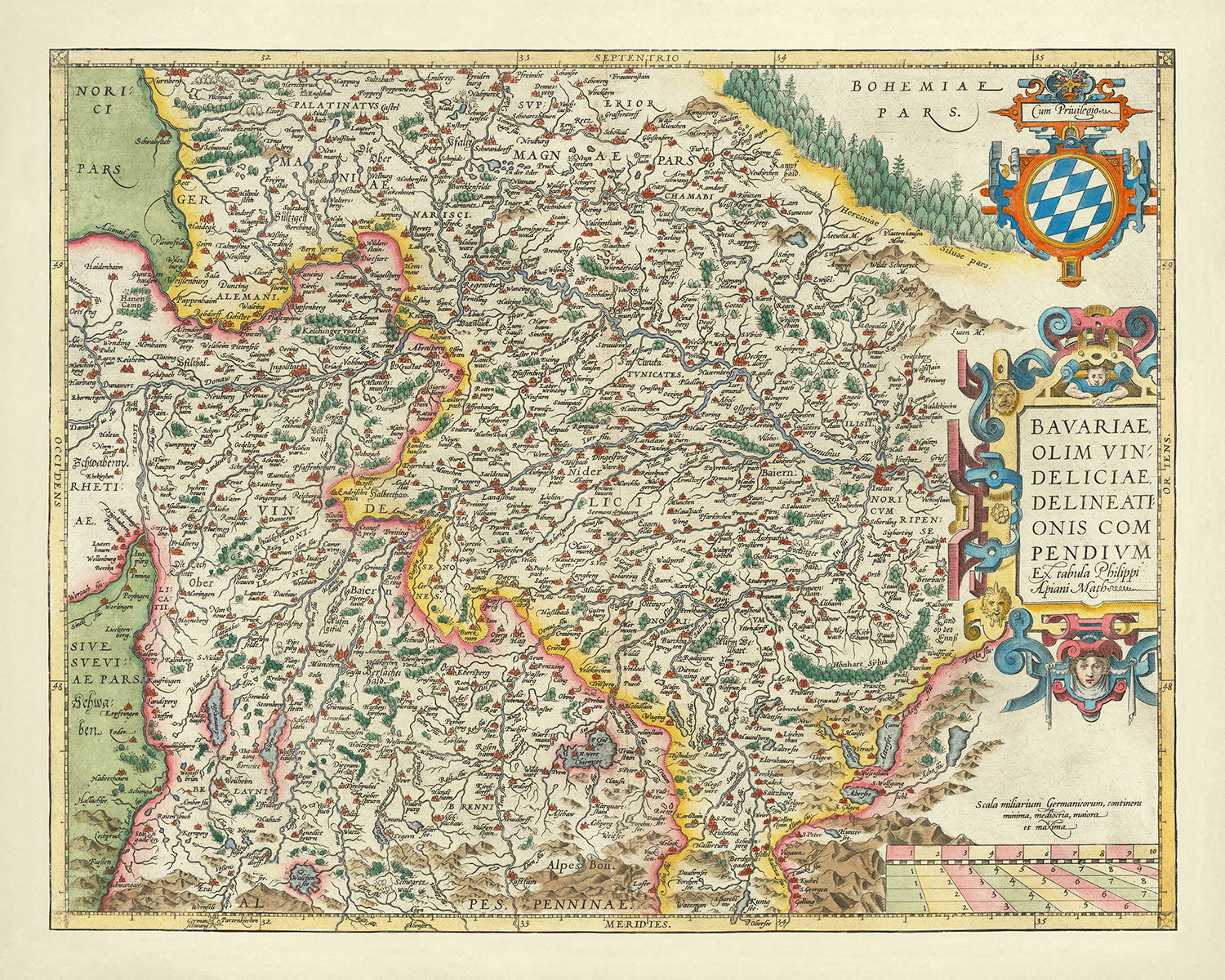


Vecchia mappa della Baviera di Ortelius, 1579: Monaco, Norimberga, fiume Danubio, Alpi tedesche
20% di sconto su 2 — 33% di sconto su 3
Aggiungi qualsiasi due articoli idonei al tuo carrello per ricevere 20% di sconto. Aggiungi un terzo e sarà gratuito (equivalente a 33% di sconto quando acquisti tre).
Nessun codice necessario — l'offerta si applica automaticamente al checkout.
Valido su tutte le mappe standard e le stampe d'arte fine. Puoi mescolare e abbinare qualsiasi design.
Se desideri spedire articoli a più indirizzi, ti preghiamo di contattarci prima di effettuare il tuo ordine.
Le commissioni personalizzate e su misura sono escluse.
Contattaci se hai domande

Choose your size
Choose your finish


(Maggiori informazioni)
Gift message & custom finish

If you want to add a gift message, or a finish (jigsaw, aluminium board, etc.) that is not available here, please request it in the "order note" when you check out.
Every order is custom made, so if you need the size adjusted slightly, or printed on an unusual material, just let us know. We've done thousands of custom orders over the years, so there's (almost) nothing we can't manage.
You can also contact us before you order, if you prefer!

- Made locally for fast, safe delivery
- No import duty or hidden fees
- Need advice? Message us on WhatsApp
Own a piece of history
7,000+ 5 star reviews


"Bavariae, Olim Vindeliciae Delineationis Compendium Ex tabula Philippi Apiani Math" è un'opera magistrale del rinomato cartografo Abraham Ortelius, realizzata nel 1579. Questa mappa squisita offre una rappresentazione dettagliata della Baviera, mostrando l'intricata rete di fiumi della regione, inclusi i prominenti fiumi Danubio e Donau. Estendendosi dalle maestose Alpi Tedesche alle regioni settentrionali di Norimberga e Friburgo, questa mappa cattura l'essenza della Baviera del XVI secolo con straordinaria precisione e arte. I dettagli meticolosi delle caratteristiche fisiche e politiche rendono questa mappa non solo una guida geografica ma anche un artefatto storico.
Abraham Ortelius, celebrato per il suo lavoro pionieristico "Theatrum Orbis Terrarum," il primo atlante moderno del mondo, porta la sua esperienza senza pari in questa mappa. La sua dedizione all'accuratezza e alla bellezza estetica è evidente in ogni aspetto del design della mappa. I cartigli decorativi e i disegni di bordo ornati riflettono le sensibilità artistiche del periodo rinascimentale, mentre le illustrazioni dettagliate di fiumi, montagne e foreste forniscono una visione completa della topografia della regione. L'opera di Ortelius è una testimonianza dei progressi nella cartografia durante la fine del XVI secolo, colmando il divario tra arte e scienza.
Il focus della mappa sulla Baviera è completato dall'inclusione di città principali come Monaco, Ratisbona, Augusta, Ingolstadt e Friburgo. Queste città, rappresentate con meticoloso dettaglio, evidenziano il paesaggio urbano della regione e la sua importanza nel contesto storico e culturale dell'epoca. La mappa delinea anche i confini politici della Baviera e delle regioni circostanti, offrendo spunti sul panorama geopolitico dell'epoca. L'intricata rete di fiumi e affluenti aumenta ulteriormente l'utilità della mappa come strumento di navigazione, mostrando anche la bellezza naturale della regione.
Oltre alle sue caratteristiche politiche e urbane, la mappa evidenzia anche la geografia fisica della Baviera. Le Alpi Tedesche, con le loro cime scoscese e le loro vaste catene montuose, sono esposte in modo prominente, fornendo un contrasto sorprendente con le lussureggianti foreste e le colline ondulate della regione. La rappresentazione di queste caratteristiche naturali non è solo accurata ma anche artisticamente realizzata, catturando l'essenza del paesaggio variegato della Baviera. L'inclusione di queste caratteristiche fisiche aggiunge profondità e dimensione alla mappa, rendendola una risorsa preziosa per storici, geografi e appassionati d'arte.
Il significato storico di questa mappa si estende oltre la sua accuratezza geografica e bellezza artistica. Come parte del "Theatrum Orbis Terrarum" di Ortelius, questa mappa rappresenta una pietra miliare nella storia della cartografia. Riflette il crescente interesse per l'esplorazione e il desiderio di creare rappresentazioni complete e accurate del mondo. La rappresentazione dettagliata della Baviera e delle sue regioni circostanti offre uno sguardo nel passato, fornendo preziose informazioni sul panorama politico, culturale e naturale dell'epoca. Questa mappa non è solo uno strumento di navigazione ma una finestra sulla storia e sul patrimonio della Baviera.
Città e paesi su questa mappa
- Monaco
- Norimberga
- Augusta
- Ratisbona
- Ingolstadt
- Friburgo
Caratteristiche e luoghi notevoli
- Il fiume Danubio
- Il fiume Donau
- Le Alpi Tedesche
- Aree boschive
- Catene montuose
- Il cartiglio decorativo con il titolo della mappa
- Il design di bordo ornato
- Fiumi e affluenti
- Illustrazioni dettagliate delle caratteristiche fisiche
- Confini politici storici
Contesto storico e di design
- Questa mappa decorativa di Abraham Ortelius mostra la Baviera, centrata sui fiumi Danubio e Donau, e i loro affluenti.
- La mappa si estende dalle Alpi tedesche a Norimberga e Friburgo a nord.
- Le principali città includono Monaco, Ratisbona, Augusta, Ingolstadt, ecc.
- La mappa è stata realizzata nel 1579.
- Abraham Ortelius è noto per aver creato "Theatrum Orbis Terrarum," il primo atlante moderno del mondo.
- La mappa delinea i confini politici della Baviera e delle regioni circostanti.
- Include caratteristiche fisiche come fiumi, montagne e foreste.
- La mappa riflette la comprensione geografica e il paesaggio politico della fine del XVI secolo.
- La mappa è altamente decorativa, con elaborate cartucce e disegni di bordo ornati.
- Presenta illustrazioni dettagliate delle caratteristiche fisiche e politiche.
- La mappa è significativa come parte del "Theatrum Orbis Terrarum" di Ortelius, che ha segnato un importante progresso nella cartografia e nella creazione di atlanti moderni.
Si prega di controllare attentamente le immagini per assicurarsi che una specifica città o luogo sia mostrato su questa mappa. Puoi anche contattarci e chiedere di controllare la mappa per te.
Questa mappa appare fantastica in ogni dimensione, ma consiglio sempre di optare per una dimensione più grande se hai spazio. In questo modo puoi facilmente distinguere tutti i dettagli.
Questa mappa appare incredibile in dimensioni fino a 90 pollici (230 cm). Se stai cercando una mappa più grande, per favore contattaci.
Il modello nelle immagini dell'elenco tiene la versione 16x20 pollici (40x50 cm) di questa mappa.
La quinta immagine dell'elenco mostra un esempio del mio servizio di personalizzazione della mappa.
Se stai cercando qualcosa di leggermente diverso, dai un'occhiata alla mia collezione delle migliori mappe antiche per vedere se qualcosa attira la tua attenzione.
Per favore contattami per verificare se un certo luogo, monumento o caratteristica è mostrato su questa mappa.
Questo sarebbe un meraviglioso regalo per un compleanno, Natale, Festa del Papà, pensionamento, anniversario o inaugurazione per qualcuno delle aree coperte da questa mappa.
Questa mappa è disponibile come stampa giclée su carta opaca archiviata senza acidi, oppure puoi acquistarla incorniciata. La cornice è una semplice cornice nera che si adatta alla maggior parte degli stili. Per favore contattami se desideri un colore o un materiale della cornice diverso. Le mie cornici sono dotate di un acrilico super chiaro di grado museale (perspex/acrylite), che è significativamente meno riflettente del vetro, più sicuro e arriverà sempre in perfette condizioni.
This map is also available as a float framed canvas, sometimes known as a shadow gap framed canvas or canvas floater. The map is printed on artist's cotton canvas and then stretched over a handmade box frame. We then "float" the canvas inside a wooden frame, which is available in a range of colours (black, dark brown, oak, antique gold and white). This is a wonderful way to present a map without glazing in front. See some examples of float framed canvas maps and explore the differences between my different finishes.
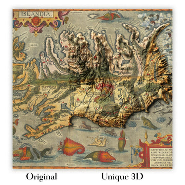
For something truly unique, this map is also available in "Unique 3D", our trademarked process that dramatically transforms the map so that it has a wonderful sense of depth. We combine the original map with detailed topography and elevation data, so that mountains and the terrain really "pop". For more info and examples of 3D maps, check my Unique 3D page.
Many of our maps and art prints are chosen as thoughtful gifts for homes, offices, studies and meaningful places.
Choose a framed option for the easiest ready-to-hang gift, or choose an unframed print if the recipient may prefer to select their own frame.
We make orders locally in 23 countries around the world, so gifts can often be produced close to the recipient. This helps them arrive faster, travel more safely, and avoid customs or import duty surprises.
- We can deliver directly to the recipient
- Framed pieces arrive ready to hang
- Unframed prints are carefully packed in a strong protective tube
- Almost every order is made locally, for faster, safer gifting
- 90-day returns give the recipient time to decide
If you are not sure what to choose, please contact us. We can help you pick the right map, size, finish or delivery option.
Most orders are made locally and delivered in around 2–3 working days, depending on the product, size and destination.
We print and frame maps and artwork in 23 countries around the world, so your order is usually made close to you or your recipient. That means faster delivery, less time in transit, and no customs or import duty surprises.
Personalised and customised pieces usually take an extra 1–2 working days, because we prepare your design and send it to you for approval before printing.
Very large framed orders can take a little longer, as they need extra care in production and delivery.
Every order is carefully packaged: unframed prints are sent in a strong protective tube, while framed pieces are securely packed with protective materials around the frame.
If you need your order by a particular date, please contact us before ordering. We’ll check the best production route and delivery option for your location.
Express delivery is available at checkout for most countries. Next-day delivery is available in the UK, US, Singapore and the UAE.
Your order is covered by our 90-day returns policy and 10-year guarantee.
Our standard frame is a gallery-style black ash hardwood frame, with a simple, modern look. It is approximately 20mm (0.8in) wide. You can also view some lovely customer photos of framed maps and art.
We use super-clear acrylic glazing, also known as Perspex or Acrylite, instead of traditional glass. It is lighter, safer, and has lower reflectivity, giving the artwork a clearer, cleaner appearance.
Six standard frame colours are available at no extra cost: black, dark brown, dark grey, oak, white, and antique gold. Custom framing and mounting/matting is also available for customers looking for something more specific.
Most maps, art prints, and illustrations are also available as a framed canvas. We use matte cotton canvas, stretch it over a sustainably sourced wooden box frame, and then float the piece within a wooden outer frame. The finished result is beautifully presented, with no glazing between you and the artwork.
All frames are supplied ready to hang, with either string or brackets fitted to the back. Very large frames will include heavy-duty hanging plates and/or a mounting baton. If you have any questions, please get in touch.
We can also supply old maps and artwork on canvas, foam board, cotton rag, and other materials.
If you would prefer to frame your map or artwork yourself, please read our size guide before ordering.
My maps are extremely high quality reproductions of original maps.
I source original, rare maps from libraries, auction houses and private collections around the world, restore them at my London workshop, and then use specialist giclée inks and printers to create beautiful maps that look even better than the original.
My maps are printed on acid-free archival matte (not glossy) paper that feels very high quality and almost like card. In technical terms the paper weight/thickness is 10mil/200gsm. It's perfect for framing.
I print with Epson ultrachrome giclée UV fade resistant pigment inks - some of the best inks you can find.
I can also make maps on canvas, cotton rag and other exotic materials.
Learn more about The Unique Maps Co.
Map personalisation
If you're looking for the perfect anniversary or housewarming gift, I can personalise your map to make it truly unique. For example, I can add a short message, or highlight an important location, or add your family's coat of arms.
The options are almost infinite. Please see my map personalisation page for some wonderful examples of what's possible.
To order a personalised map, select "personalise your map" before adding it to your basket.
Get in touch if you're looking for more complex customisations and personalisations.
Map ageing
I have been asked hundreds of times over the years by customers if they could buy a map that looks even older.
Well, now you can, by selecting Aged before you add a map to your basket.
All the product photos you see on this page show the map in its Original form. This is what the map looks like today.
If you select Aged, I will age your map by hand, using a special and unique process developed through years of studying old maps, talking to researchers to understand the chemistry of aging paper, and of course... lots of practice!
If you're unsure, stick to the Original colour of the map. If you want something a bit darker and older looking, go for Aged.
Se non sei soddisfatto del tuo ordine per qualsiasi motivo, contattami per un rimborso senza problemi. Si prega di consultare la nostra politica di reso e rimborso per ulteriori informazioni.
Sono molto sicuro che ti piacerà la tua mappa restaurata o la stampa d'arte. Lo faccio dal 1984. Sono un venditore Etsy a 5 stelle. Ho venduto decine di migliaia di mappe e stampe d'arte e ho oltre 5.000 recensioni reali a 5 stelle.
Utilizzo un processo unico per restaurare mappe e opere d'arte che richiede molto tempo e lavoro. Trovare le mappe e le illustrazioni originali può richiedere mesi. Utilizzo tecnologia all'avanguardia e incredibilmente costosa per scannerizzare e restaurarle. Di conseguenza, garantisco che le mie mappe e stampe d'arte siano superiori alle altre - ecco perché posso offrire un rimborso senza problemi.
Quasi tutte le mie mappe e stampe d'arte sembrano fantastiche a grandi dimensioni (200 cm, 6,5 piedi+) e posso anche incorniciarle e consegnarle a te, tramite un corriere speciale per oggetti di grandi dimensioni. Contattami per discutere delle tue esigenze specifiche.
Or try searching for something!


